|
|
 |
|

|
|
|
Forest classification for Motuo County: A method based on spatio-temporal-spectral characteristics |
WU Yuxin1,2( ), WANG Juanle2,4(), HAN Baomin1, YAN Xinrong2,3 ), WANG Juanle2,4(), HAN Baomin1, YAN Xinrong2,3 |
1. School of Architecture Engineering, Shandong University of Technology, Zibo 255000, China
2. State Key Laboratory of Resources and Environment Information System, Institute of Geographic Sciences and Natural Resources Research, Chinese Academy of Sciences, Beijing 100101, China
3. University of Chinese Academy of Sciences, Beijing 100049, China
4. Jiangsu Center for Collaborative Innovation in Geographical Information Resource Development and Application, Nanjing 210023, China |
|
|
|
|
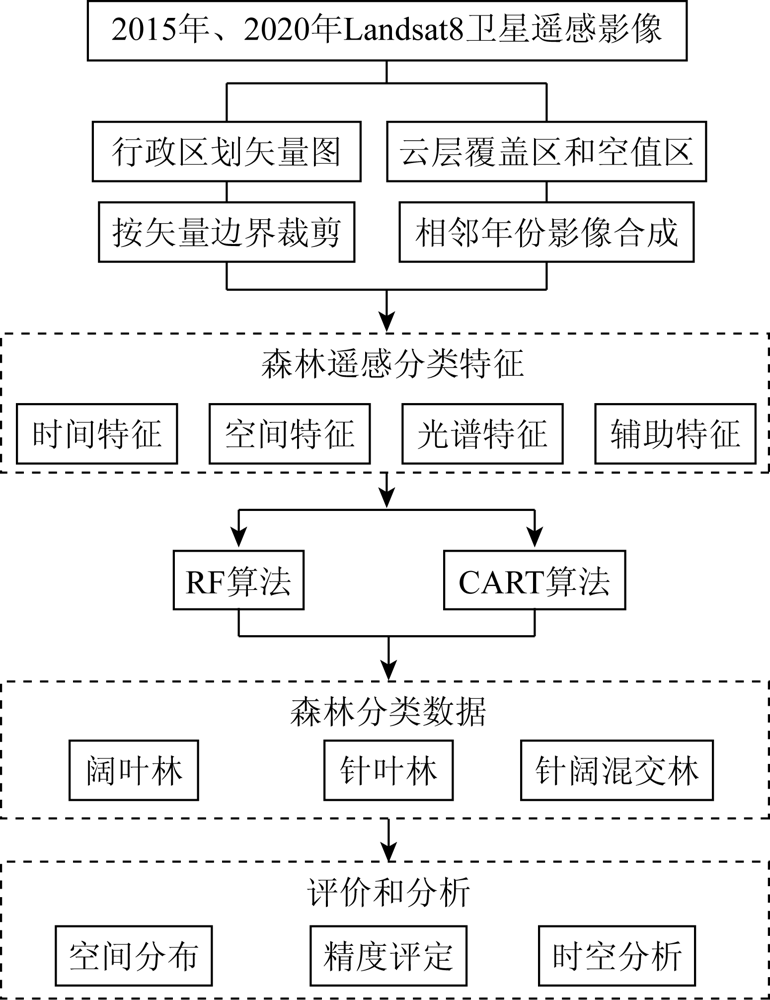
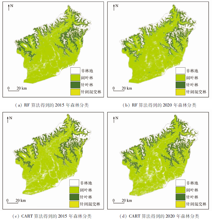
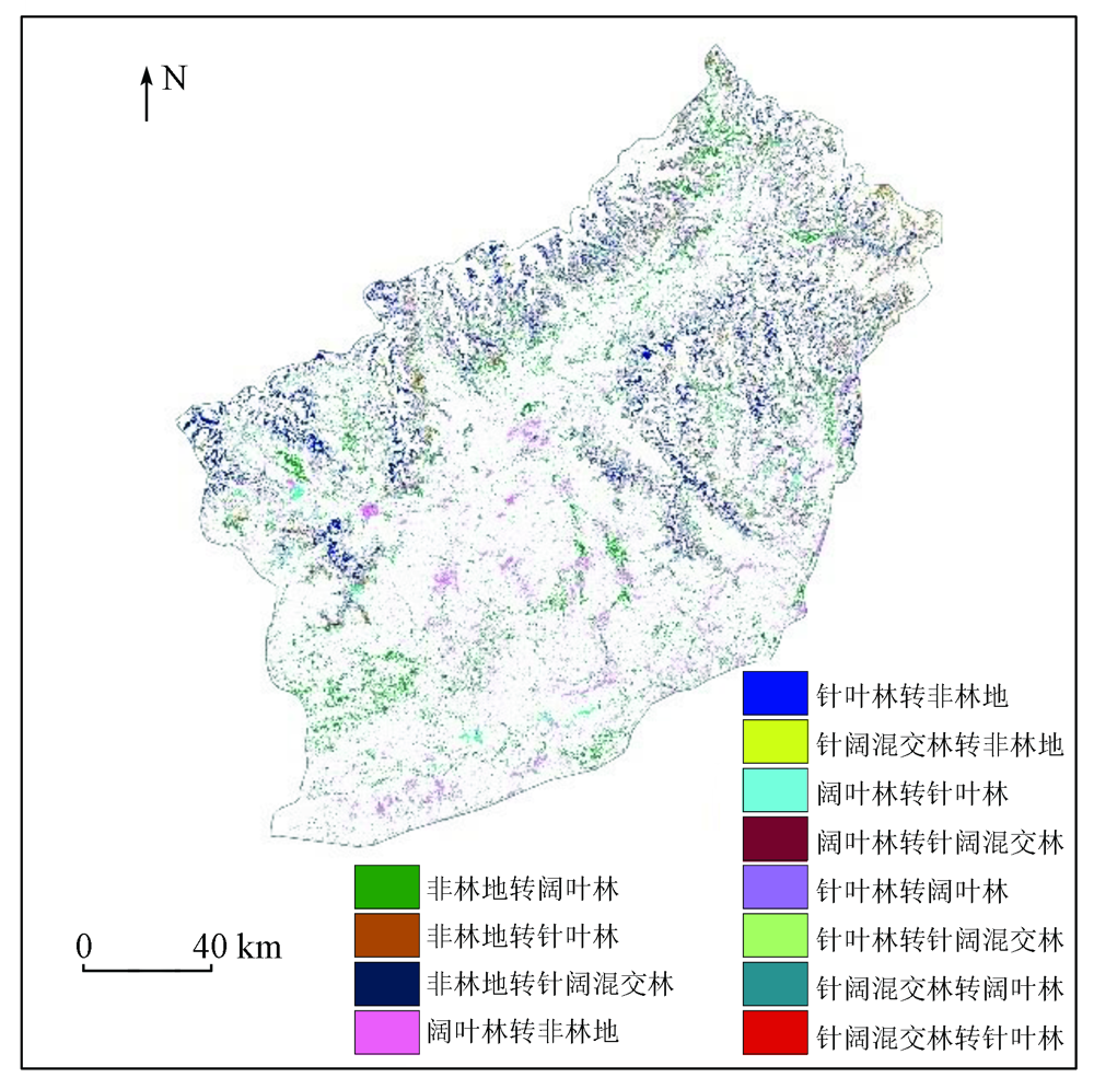
Abstract The forest area of Tibet ranks among the top in China, and the forest resources in Tibet play an important role in water conservation and ecological service. Therefore, it is of great significance to assess the assets of forest natural resources in this region. However, existing products and statistical data related to forest cover fail to meet the demands for the assessment of forest natural resource assets in this region, and it is necessary to explore a fine-scale forest classification method suitable for this region. Based on the cloud computing platform Google Earth Engine (GEE), this study constructed the temporal, spatial, spectral, and auxiliary feature sets of the forest coverage in Motuo County using the Landsat8 remote sensing images of 2015 and 2020, as well as field survey data, and the basic geographic data. Then, it conducted forest classification using the random forest (RF) and classification and regression tree (CART) algorithms. As indicated by the accuracy evaluation of the assessment results obtained using the two algorithms, the forest classification results of 2015 and 2020 obtained using the RF algorithm had relatively high accuracy, with overall classification accuracy of 0.88 and 0.87, respectively and Kappa coefficients of both greater than 0.8. The analyses of the areal and spatio-temporal characteristics of forest classification results show that: ① Motuo County had a total forest area of 34 000 km2 in 2015, with a forest cover rate of up to 84.63%, which was 2% less than that in 2020; ② The forest resources in Motuo County are dominated by broadleaved forests, which are mainly distributed in Yarlung Zangbo Grand Canyon and low-altitude areas and accounted for 72.27% and 75.37% of the total forest area in 2015 and 2020, respectively. Coniferous forests accounted for 25.96% and 23.19% of the total forest area in 2015 and 2020, respectively and are concentrated in high-altitude areas, such as the Namcha Barwa and Gyala Peri peaks. This study determined the spatio-temporal distribution of the forests in Motuo County in 2015 and 2020 by developing a spatio-temporal-spectral classification method. It can provide a reference method for calculating specific forest cover indices SDGs and fill the gap of forest data of small zones. The obtained monitoring data will provide data support for the natural asset assessment and ecological function evaluation in Motuo County.
|
| Keywords
forest classification
spatio-temporal-spectral characteristics
random forest
classification and regression tree
Motuo County
|
|
|
|
Issue Date: 20 March 2023
|
|
|
| [1] |
Ridder R M. Global forest resources assessment 2010:Options and recommendations for a global remote sensing survey of forests[J]. FAO for Resources Assessment Programme Work Paper, 2007,141.
|
| [2] |
张建龙. 中国森林资源报告[M]. 北京: 中国林业出版社, 2019.
|
| [2] |
Zhang J L. Forest resources report of China[M]. Beijing: China Forestry Publishing House, 2019.
|
| [3] |
Hansen M C, Potapov P V, Moore R, et al. High-resolution global maps of 21st-century forest cover change[J]. Science, 2013, 342(6160):850-853.
doi: 10.1126/science.1244693
pmid: 24233722
|
| [4] |
Shimada M, Itoh T, Motooka T, et al. New global forest/non-forest maps from ALOS PALSAR data (2007—2010)[J]. Remote Sensing of Environment, 2014, 155:13-31.
doi: 10.1016/j.rse.2014.04.014
url: https://linkinghub.elsevier.com/retrieve/pii/S0034425714001527
|
| [5] |
陈军, 廖安平, 陈晋, 等. 全球30m地表覆盖遥感数据产品-Globe Land30[J]. 地理信息世界, 2017, 24(1):1-8.
|
| [5] |
Chen J, Liao A P, Chen J, et al. 30-Meter global land cover data product-globeLand30/GEOMATICS WORLD[J]. Geographical Information World, 2017, 24(1):1-8.
|
| [6] |
Aurélie Bellavia, 徐希燕. 全球300米分辨率欧空局陆地覆盖数据(1992—2015)[Z]. 北京: 国家青藏高原科学数据中心, 2018.
|
| [6] |
Aurélie B, Xu X Y. Global ESA CCI land cover classification map (1992—2015)[Z]. Beijing: National Tibetan Plateau Data Center, 2018.
|
| [7] |
Yu L, Wang J, Gong P. Improving 30 m global land-cover map FROM-GLC with time series MODIS and auxiliary data sets:A segmentation-based approach[J]. International Journal of Remote Sensing, 2013, 34(16):5851-5867.
doi: 10.1080/01431161.2013.798055
url: https://www.tandfonline.com/doi/full/10.1080/01431161.2013.798055
|
| [8] |
Li C C, Wang J, Hu L Y, et al. A circa 2010 thirty meter resolution forest map for China[J]. Remote Sensing, 2014, 6(6):5325-5343.
doi: 10.3390/rs6065325
url: http://www.mdpi.com/2072-4292/6/6/5325
|
| [9] |
林芝地区统计局、 国家统计局林芝调查队编印. 林芝地区统计年鉴 2015[M]. 林芝: 林芝地区统计局, 2016.
|
| [9] |
Nyingchi Regional Bureau of Statistics,Nyingchi Survey Team, National Bureau of Statistics. Nyingchi Regional Statistical Yearbook 2015[M]. Nyingch: Nyingchi Regional Bureau of Statistics, 2016.
|
| [10] |
郝斌飞, 韩旭军, 马明国, 等. Google Earth Engine在地球科学与环境科学中的应用研究进展[J]. 遥感技术与应用, 2018, 33(4):600-611.
|
| [10] |
Hao B F, Han X J, Ma M G, et al. Research progress on the application of Google Earth Engine in geoscience and environmental sciences[J]. Remote Sensing Technology and Application, 2018. 33(4):600-611.
|
| [11] |
徐晗泽宇, 刘冲, 王军邦, 等. Google Earth Engine平台支持下的赣南柑橘果园遥感提取研究[J]. 地球信息科学学报, 2018, 20(3):396-404.
doi: 10.12082/dqxxkx.2018.170553
|
| [11] |
Xu Han Z Y, Liu C, Wang J B, et al. Study on extraction of citrus orchard in Gannan region based on Google Earth Engine platform[J]. Journal of Geo-information Science, 2018, 20(3):396-404.
|
| [12] |
Wang J, Xiao X M, Qin Y W, et al. Mapping the dynamics of eastern redcedar encroachment into grasslands during 1984—2010 through PALSAR and time series Landsat images[J]. Remote Sensing of Environment, 2017, 190:233-246.
doi: 10.1016/j.rse.2016.12.025
url: https://linkinghub.elsevier.com/retrieve/pii/S0034425716305041
|
| [13] |
Barboza C E, Turpo C E Y, de Almeida C M, et al. Monitoring wildfires in the northeastern peruvian amazon using Landsat8 and Sentinel-2 imagery in the GEE platform[J]. ISPRS International Journal of Geo-Information, 2020, 9(10):564.
doi: 10.3390/ijgi9100564
url: https://www.mdpi.com/2220-9964/9/10/564
|
| [14] |
Pekel J F, Cottam A, Gorelick N, et al. High-resolution mapping of global surface water and its long-term changes[J]. Nature, 2016, 540(7633):418-422.
doi: 10.1038/nature20584
|
| [15] |
Xiao W, Xu S, He T. Mapping paddy rice with sentinel-1/2 and phenology-,object-based algorithm-A implementation in Hangjiahu plain in China using GEE platform[J]. Remote Sensing, 2021, 13(5):990.
doi: 10.3390/rs13050990
url: https://www.mdpi.com/2072-4292/13/5/990
|
| [16] |
Cao X M, Gao X H, Shen Z Y, et al. Expansion of urban impervious surfaces in Xining City based on GEE and Landsat time series data[J]. IEEE Access, 2020, 8:147097-147111.
doi: 10.1109/Access.6287639
url: https://ieeexplore.ieee.org/xpl/RecentIssue.jsp?punumber=6287639
|
| [17] |
李若楠, 欧光龙, 代沁伶, 等. 基于GEE和Landsat时间序列数据的香格里拉森林类型分类研究[J]. 西南林业大学学报(自然科学), 2020, 40(5):115-125.
|
| [17] |
Li R N, Ou G L, Dai Q L, et al. Forest types classification of Shangri-La based on Google Earth Engine and landsat time-series data[J]. Journal of Southwest Forestry University (Natural Science), 2020, 40(5):115-125.
|
| [18] |
娄佩卿, 付波霖, 林星辰, 等. 基于GEE的1998—2018年京津冀土地利用变化对生态系统服务价值的影响[J]. 环境科学, 2019, 40(12):5473-5483.
|
| [18] |
Lou P Q, Fu B L, Lin X C, et al. Influence of land use change on ecosystem service value based on GEE in the Beijing-Tianjin-Hebei region from 1998 to 2018[J]. Environmental Science, 2019, 40(12):5473-5483.
|
| [19] |
Belgiu M, Drăguţ L. Random forest in remote sensing:A review of applications and future directions[J]. ISPRS Journal of Photogrammetry and Remote Sensing, 2016, 114:24-31.
doi: 10.1016/j.isprsjprs.2016.01.011
url: https://linkinghub.elsevier.com/retrieve/pii/S0924271616000265
|
| [20] |
Mountrakis G J, Ogole I C. Support vector machines in remote sensing:A review[J]. ISPRS Journal of Photogrammetry and Remote Sensing, 2011, 66:247-259.
doi: 10.1016/j.isprsjprs.2010.11.001
url: https://linkinghub.elsevier.com/retrieve/pii/S0924271610001140
|
| [21] |
Pal M, Mather P M. An assessment of the effectiveness of decision tree methods for land cover classification[J]. Remote Sensing of Environment, 2003, 86(4):554-565.
doi: 10.1016/S0034-4257(03)00132-9
url: https://linkinghub.elsevier.com/retrieve/pii/S0034425703001329
|
| [22] |
Pal M. Random forest classifier for remote sensing classification[J]. International Journal of Remote Sensing. 2005, 26(1):217-222.
doi: 10.1080/01431160412331269698
url: https://www.tandfonline.com/doi/full/10.1080/01431160412331269698
|
| [23] |
Ghimire B, Rogan J, Galiano V R, et al. An evaluation of bagging,boosting,and random forests for land-cover classification in cape cod,massachusetts,USA[J]. GIScience & Remote Sensing, 2012, 49(5):623-643.
|
| [24] |
Pal M, Mather P M. Support vector machines for classification in remote sensing[J]. International Journal of Remote Sensing, 2005, 26(5):1007-1011.
doi: 10.1080/01431160512331314083
url: https://www.tandfonline.com/doi/full/10.1080/01431160512331314083
|
| [25] |
Rogan J, Miller J, Stow D, et al. Land-cover change monitoring with classification trees using Landsat TM and ancillary data[J]. Photogrammetric Engineering & Remote Sensing, 2003, 69(7):793-804.
|
| [26] |
Hansen M, Dubayah R, DeFries R. Classification trees:An alternative to traditional land cover classifiers[J]. International Journal of Remote Sensing, 1996, 17(5):1075-1081.
doi: 10.1080/01431169608949069
url: https://www.tandfonline.com/doi/full/10.1080/01431169608949069
|
| [27] |
Vega Isuhuaylas L A, Hirata Y, Ventura Santos L C, et al. Natural forest mapping in the Andes (Peru):A comparison of the performance of machine-learning algorithms[J]. Remote Sensing, 2018, 10(5):782.
doi: 10.3390/rs10050782
url: http://www.mdpi.com/2072-4292/10/5/782
|
| [28] |
Liu Y N, Gong W S, Hu X Y, et al. Forest type identification with random forest using Sentinel-1A,Sentinel-2A,multi-temporal Landsat-8 and DEM data[J]. Remote Sensing, 2018, 10(6):946.
doi: 10.3390/rs10060946
url: http://www.mdpi.com/2072-4292/10/6/946
|
| [29] |
Wang D Z, Wan B, Qiu P H, et al. Evaluating the performance of Sentinel-2,Landsat8 and Pléiades-1 in mapping mangrove extent and species[J]. Remote Sensing, 2018, 10(9):1468.
doi: 10.3390/rs10091468
url: http://www.mdpi.com/2072-4292/10/9/1468
|
| [30] |
柳应华. 西藏墨脱县产业发展研究[J]. 中国藏学, 2013(3):30-34.
|
| [30] |
Liu Y H. Study on industrial development of Motuo County,Xizang Province[J]. Chinese Tibetology, 2013(3):30-34.
|
| [31] |
朱文泉, 林文鹏. 遥感数字图像处理:原理与方法[M]. 北京: 高等教育出版社, 2015.
|
| [31] |
Zhu W Q, Lin W P. Remote sensing digital image processing[M]. Beijing: Higher Education Press, 2015.
|
| [32] |
Guo X J, Zhang C C, Luo W R, et al. Urban impervious surface extraction based on multi-features and random forest[J]. IEEE Access, 2020, 8:226609-226623.
doi: 10.1109/Access.6287639
url: https://ieeexplore.ieee.org/xpl/RecentIssue.jsp?punumber=6287639
|
| [33] |
刘龙飞, 陈云浩, 李京. 遥感影像纹理分析方法综述与展望[J]. 遥感技术与应用, 2003(6):441-447.
|
| [33] |
Liu L F, Chen Y H, Li J. Remote Sensing image texture analysis:A review and prospect[J]. Remote Sensing Technology and Application, 2003(6):441-447.
|
| [34] |
董师师, 黄哲学. 随机森林理论浅析[J], 集成技术, 2013, 2(1):1-7.
|
| [34] |
Dong S S, Huang Z X. A brief theoretical overview of random forests[J]. Journal of Integration Technology, 2013. 2(1):1-7.
|
| [35] |
陈云, 戴锦芳, 李俊杰. 基于影像多种特征的CART决策树分类方法及其应用[J]. 地理与地理信息科学, 2008(2):33-36.
|
| [35] |
Chen Y, Dai J Fg, Li J J. CART-based decision tree classifier using multi-feature of image and its application[J]. Geography and Geo-Information Science, 2008(2):33-36.
|
| [36] |
张敬垚. 基于随机森林算法的关键蛋白识别方法研究[D]. 长春: 吉林农业大学, 2019.
|
| [36] |
Zhang J Y. Research on essential protein recognition based on random forest algorithm[D]. Changchun: Jilin Agricultural University, 2019.
|
| [37] |
魏梦莹. 林芝地区森林植被分布及动态变化监测研究[D]. 西安: 长安大学, 2018.
|
| [37] |
Wei M Y. Study on forest vegetation distribution and forest resources change monitoring in Linzhi area[D]. Xi’an: Chang’an University, 2018.
|
| [38] |
安森鹏, 高振岭, 王磊. 气候变化对大兴安岭北部森林生态系统的影响[J]. 农业与技术, 2013, 33(1):55.
|
| [38] |
An S P, Gao Z L, Wang L. Effects of climate change on forest ecosystem in northern Daxing’an mountains[J]. Agriculture and Technology, 2013, 33(1):55.
|
| [39] |
魏晨辉. 黑龙江流域景观与气候驱动的植物多样性和碳汇变化研究[D]. 长春: 中国科学院大学(中国科学院东北地理与农业生态研究所), 2021.
|
| [39] |
Wei C H. Landscape and climate-driven changes in plant diversity and carbon sink in the Heilongjiang River Basin[D]. Changchun: University of Chinese Academy of Sciences (Northeast Institute of Geography and Agroecology,Chinese Academy of Sciences),2021.
|
| [40] |
于世勇, 史绍林. 全球变化对森林的影响[J]. 温带林业研究, 2021, 4(2):8-12.
|
| [40] |
Yu S Y, Shi S L. Research on essential protein recognition based on random forest algorithm[J]. Journal of Temperate Forestry Research, 2021, 4(2):8-12.
|
|
Viewed |
|
|
|
Full text
|
|
|
|
|
Abstract
|
|
|
|
|
Cited |
|
|
|
|
| |
Shared |
|
|
|
|
| |
Discussed |
|
|
|
|
 2023,
Vol. 35
2023,
Vol. 35