Please wait a minute...
 
Remote Sensing for Natural Resources    2023, Vol. 35 Issue (1) : 251-257     DOI: 10.6046/zrzyyg.2022006
|
A geographic data fusion and update method based on geometric and attribute matching
SHI Shanqiu()
Provincial Geomatics Center of Jiangsu, Nanjing 210013, China
Download: PDF(1229 KB)   HTML
Export: BibTeX | EndNote | Reference Manager | ProCite | RefWorks    
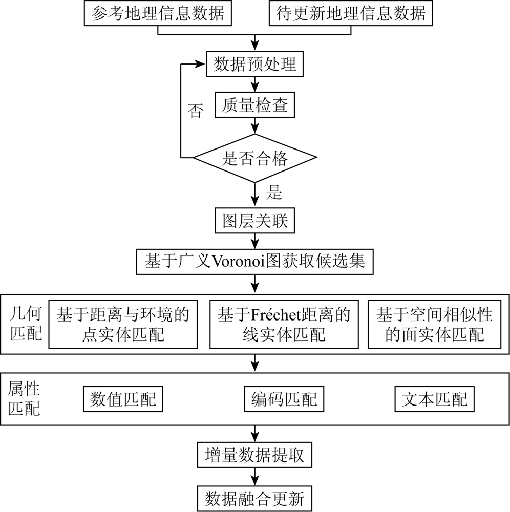
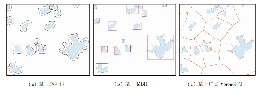
Abstract  

The inconsistency of multi-source geographic data in scale, geometric position, and attribute cause difficult data fusion and update. This study proposed a fusion and update method for geographic data based on geometric and attribute matching. First, the candidate set was acquired using the generalized Voronoi diagram, thus effectively improving the acquisition efficiency and reducing the impact of unrelated targets on the candidate set. Then, the matching analysis of point, line, and plane data was made using key techniques such as geometric and attribute matching. Finally, based on the matching results, the incremental data were extracted from the reference geographic information data, followed by fusion and update of target data. The experimental results show that the method proposed in this study can efficiently identify and extract incremental data and serves as a reference for the innovative exploration into the update mode of monitoring data.

Keywords geometric matching      attribute matching      fusion and update      incremental data     
ZTFLH:  P208  
Issue Date: 20 March 2023
Service
E-mail this article
E-mail Alert
RSS
Articles by authors
Shanqiu SHI
Cite this article:   
Shanqiu SHI. A geographic data fusion and update method based on geometric and attribute matching[J]. Remote Sensing for Natural Resources, 2023, 35(1): 251-257.
URL:  
https://www.gtzyyg.com/EN/10.6046/zrzyyg.2022006     OR     https://www.gtzyyg.com/EN/Y2023/V35/I1/251
Fig.1  Technology roadmap of geographic information data fusion and update
Fig.2  Comparison of candidate set acquisition methods
要素名称 融合更新内容 分类名称 基础测绘
数据要素
数量/个
国情监测
数据要素
数量/个
几何更新
要素数
量/个
属性更新
要素数
量/个
几何属性
更新要素
数量/个
水系 重要水系 水系的改道、新开挖的河流、新建大中型水库等 等级河流 5 068 5 048 3 380 56 3 324
水库 1 718 1 581 465 44 421
重要水系附属设施 大中型水闸和船闸、泵站、干堤等
水闸 45 836 15 500 1 346 8 881 457
船闸 417 12 2 3 4
泵站 85 683 67 983 634 12 716 1 034
干堤 6 134 5 675 3 679 854 2 918
居民
地及
设施
重要设施或标志性建筑 大中型自来水厂和污水处理厂、大型医院、学校等 自来水厂 916 1 435 887 69 801
污水处理厂 727 888 384 51 335
医院 15 941 5 717 1 745 2 829 399
学校 9 794 14 135 5 773 1 094 1 509
交通 飞机场 机场及附属设施 机场 30 12 0 0 1
铁路 高铁、动车相关铁路
铁路 2 668 453 373 71 302
高速公路及国省道 更新高速、国道、省道
等级公路 57 784 61 368 39 393 25 421 13 972
重要交通附属设施 大型交通枢纽,火车站,县级及以上的长途汽车站,高速、国省道相关的大型桥梁、隧道,大中型渡口、大中型码头等
火车站 181 135 30 5 24
汽车站 722 719 222 46 172
桥梁 199 020 6 505 17 466 17 427 314
隧道 736 188 125 17 119
渡口 57 70 53 9 34
码头 6 080 2 595 479 363 326
要素名称 融合更新内容 分类名称 基础测绘
数据要素
数量/个
国情监测
数据要素
数量/个
几何更新
要素数
量/个
属性更新
要素数
量/个
几何属性
更新要素
数量/个
境界
与行
政区
县级及以上行政境界 主要是行政区划的调整 省界 64 46 35 0 35
市界 36 36 3 0 3
区县界 177 175 27 0 27
国省级自然经济文化区域 经国家或省级政府颁布的自然保护区、国家森林公园、AAAA级及以上风景旅游区、世界自然或文化遗产、高新技术开发区、经济开发区、农业开发区、保税区等 自然文化保护区 115 157 139 1 138
国有农林、牧场 57 107 83 16 80
开发区、保税区 150 197 70 9 61
地名 乡镇级及以上行政地名 主要是行政区划调整或名称变更后的名称、驻地的更新 乡镇级以上 1 433 930 104 63 62
Tab.1  Results of geographic information data fusion and update
匹配算法 数据 匹配精度 搜索区域
创建时间/s
匹配效率/s
名称 数量/个 R P F
基于缓冲区和空间相似性的匹配 国情监测数据 1 483 0.503 5 0.732 3 0.596 7 5.7 12.6
基础测绘数据 1 698
基于MBR和空间相似性的匹配 国情监测数据 1 483 0.493 5 0.794 4 0.608 8 6.9 15.0
基础测绘数据 1 698
基于Voronoi图和空间相似性的匹配 国情监测数据 1 483 0.612 6 0.813 3 0.698 8 183.0 8.2
基础测绘数据 1 698
Tab.2  Evaluation of candidate set acquisition
匹配算法 数据 匹配精度 匹配效率/s
名称 数量/个 R P F
基于距离相似度的点实体匹配 国情监测数据 21 770 0.535 4 0.730 0 0.617 7 13.8
基础测绘数据 20 770
基于距离与环境的点实体匹配 国情监测数据 21 770 0.518 4 0.776 0 0.621 6 22.7
基础测绘数据 20 770
Tab.3  Quality evaluation of point entity matching
匹配算法 数据 匹配精度 匹配效率/s
名称 原始弧段数/个 构建线段模型 R P F
基于Fréchet距离的线实体匹配 国情监测数据 225 060 0.501 9 0.580 8 0.538 5 209.3
基础测绘数据 64 663
基于Fréchet距离和线段模型的线实体匹配 国情监测数据 225 060 59 165 0.760 2 0.863 3 0.808 5 613.1
基础测绘数据 64 663 56 170
Tab.4  Quality evaluation of line entity matching
匹配算法 数据 匹配精度 匹配效率/s
名称 数量/个 R P F
基于空间相似性的面实体匹配 国情监测数据 1 483 0.612 6 0.813 3 0.698 8 8.2
基础测绘数据 1 698
基于属性和空间相似性的面实体匹配 国情监测数据 1 483 0.603 9 0.903 7 0.724 0 14.1
基础测绘数据 1 698
Tab.5  Quality evaluation of polygon entity matching
[1] 公海燕. 地理信息软件的技术进阶与应用创新[J]. 中国测绘, 2020(10):61-63.
[1] Gong H Y. Technology advancement and application innovation of geographic information software[J]. China Surveying and Mapping, 2020(10):61-63.
[2] 胡菡, 张亮, 石婷婷. 多源地理要素变化识别研究[J]. 地理空间信息, 2020, 18(6):53-55,7.
[2] Hu H, Zhang L, Shi T T. Research on the change of multi-source geographical elements[J]. Geospatial Information, 2020, 18(6):53-55,7.
[3] 李倩. 我国将构建自然资源统一调查监测体系[J]. 国土资源, 2018(8):14-15.
[3] Li Q. China will build a unified survey and monitoring system for natural resources[J]. Land and Resources, 2018(8):14-15.
[4] 王峰, 安晓亚, 朱璇. 地理空间数据增量更新版本化管理方法研究[J]. 地理空间信息, 2021, 19(2):26-29,6.
[4] Wang F, An X Y, Zhu X. Research on versioning management method for incremental update of geospatial data[J]. Geospatial Information, 2021, 19(2):26-29,6.
[5] 杨灿, 汪齐松. 多源地理矢量空间数据融合研究[J]. 测绘通报, 2019(12):112-115.
[5] Yang C, Wang Q S. Research on multi-source geospatial spatial data fusion[J]. Bulletin of Surveying and Mapping, 2019(12):112-115.
[6] 孙群. 空间数据相似性研究的若干基本问题[J]. 测绘科学技术学报, 2013, 30(5):439-442.
[6] Sun Q. Research on some fundamental issues of spatial data similarity[J]. Journal of Geomatics Science and Technology, 2013, 30(5):439-442.
[7] 安晓亚, 孙群, 肖强, 等. 一种形状多级描述方法及在多尺度空间数据几何相似性度量中的应用[J]. 测绘学报, 2011, 40(4):495-501,508.
[7] An X Y, Sun Q, Xiao Q, et al. A shape multilevel description method and application in measuring geometry similarity of multi-scale spatial data[J]. Acta Geodaetica et Cartographica Sinica, 2011, 40(4):495-501,508.
[8] 程钢, 卢小平. 顾及通名语义的汉语地名相似度匹配算法[J]. 测绘学报, 2014, 43(4):404-410,418.
[8] Cheng G, Lu X P. Matching algorithm for chinese place names by similarity in consideration of semantics of general names for places[J]. Acta Geodaetica et Cartographica Sinica, 2014, 43(4):404-410,418.
[9] 刘海龙, 钱海忠, 黄智深, 等. 采用Stroke层次结构模型的道路网匹配方法[J]. 测绘科学技术学报, 2013, 30(6):647-651,657.
[9] Liu H L, Qian H Z, Huang Z S, et al. Road network matching method with stroke-hierarchical model[J]. Journal of Geomatics Science and Technology, 2013, 30(6):647-651,657.
[10] 孙群. 多源矢量空间数据融合处理技术研究进展[J]. 测绘学报, 2017, 46(10):1627-1636.
[10] Sun Q. Research on the progress of multi-sources geospatial vector data fusion[J]. Acta Geodaetica et Cartographica Sinica, 2017, 46(10):1627-1636.
[11] 万洋洋. 基于Voronoi图的多尺度面状居民地匹配方法研究[D]. 南昌: 江西师范大学, 2016:23-26.
[11] Wan Y Y. The matching method based on Voronoi diagram for multi-scale polygonal residential areas[D]. Nanchang: Jiangxi Normal University, 2016:23-26.
[12] 张桥平, 李德仁, 龚健雅. 地图合并技术[J]. 测绘通报, 2001(7):6-8.
[12] Zhang Q P, Li D R, Gong J Y. Map conflation[J]. Bulletin of Surveying and Mapping, 2001(7):6-8.
[13] 程绵绵, 孙群, 季晓林, 等. 改进平均Fréchet距离法及在化简评价中的应用[J]. 测绘科学, 2020, 45(3):170-177.
[13] Cheng M M, Sun Q, Ji X L, et al. An improved average Fréchet distance method and application in simplification evaluation[J]. Science of Surveying and Mapping, 2020, 45(3):170-177.
[14] 邹静, 陈永刚, 龚金琪, 等. 一种利用多维目标分割比的矢量图形匹配算法[J]. 武汉大学学报(信息科学版), 2020, 45(10):1626-1632.
[14] Zou J, Chen Y G, Gong J Q, et al. An efficient matching algorithm based on vector graphics using multi-dimensional object segmentation ratio[J]. Geomatics and Information Science of Wuhan University, 2020, 45(10):1626-1632.
[15] 吴建华. 矢量空间数据实体匹配方法与应用研究[D]. 武汉: 武汉大学, 2008.
[15] Wu J H. Research on methods of entity matching and its application in vector spatial data[D]. Wuhan: Wuhan University, 2008.
[16] 郝燕玲, 唐文静, 赵玉新. 等. 基于空间相似性的面实体匹配算法研究[J]. 测绘学报, 2008, 37(4):501-506.
[16] Hao Y L, Tang W J, Zhao Y X. et al. Areal feature matching algorithm based on spatial similarity[J]. Acta Geodaetica et Cartographica Sinica, 2008, 37(4):501-506.
[17] 刘善磊, 潘九宝, 李梦梦. 等. 多源地理信息数据匹配质量评价研究[J]. 地理空间信息, 2022, 20(1):118-121,9.
[17] Liu S L, Pan J B, Li M M. et al. Research on quality evaluation of multi-source geographic information data matching[J]. Geospatial Information, 2022, 20(1):118-121,9.
[1] JIN Chengming, YANG Xingwang, JING Haitao. A RS-based study on changes in fractional vegetation cover in North Shaanxi and their driving factors[J]. Remote Sensing for Natural Resources, 2021, 33(4): 258-264.
[2] WANG Shuang, ZHANG Lei, ZHANG Junyong, WANG Yile. Characteristics of GIS applications in national fitness[J]. Remote Sensing for Natural Resources, 2021, 33(4): 265-271.
[3] WANG Ya, ZENG Zhi. An automatic repairing technology of 3D model for blind area in oblique photography based on close range image[J]. Remote Sensing for Land & Resources, 2021, 33(1): 72-77.
[4] Bo YU, Junjun ZHANG, Chungeng LI, Jubai AN. Automated extraction of roads from mobile laser scanning point clouds by image semantic segmentation[J]. Remote Sensing for Land & Resources, 2020, 32(1): 66-74.
[5] Wen JIANG, Qiming QIN. Research on emergency evacuation vulnerability of the traffic network model based on GIS[J]. Remote Sensing for Land & Resources, 2019, 31(1): 277-282.
[6] Donghui ZHANG, Yingjun ZHAO, Kai QIN. Design and construction of the typical ground target spectral information system[J]. Remote Sensing for Land & Resources, 2018, 30(4): 206-211.
[7] CHENG Tao. Exploring management and service mode for remote sensing data in big data era[J]. REMOTE SENSING FOR LAND & RESOURCES, 2016, 28(4): 202-206.
[8] ZHOU Hanghang, ZOU Zhengrong, ZHANG Yunsheng, ZHENG Te. Facade extraction from oblique point cloud considering geometrical and color information[J]. REMOTE SENSING FOR LAND & RESOURCES, 2016, 28(4): 43-48.
[9] LIU Jun, ZHAN Ran, SUN Wei. Evaluation of cultivated land suitability for Binhai New Area of Tianjin based on GIS[J]. REMOTE SENSING FOR LAND & RESOURCES, 2016, 28(3): 160-165.
[10] CHEN Yingyue, GAN Shu, TIAN Yudong, ZHOU Xibing. GIS spatial modeling in mountainous land evaluation[J]. REMOTE SENSING FOR LAND & RESOURCES, 2015, 27(2): 196-200.
[11] LIU Zhao, GAO Peichao, MIN Shiping, ZHAO Long, LUO Zhide. A 3D visualization method for high-curvature linear entity[J]. REMOTE SENSING FOR LAND & RESOURCES, 2014, 26(3): 43-47.
[12] TANG Tong, FAN Yida, YANG Siquan, WANG Lei, WANG Ping. Design and realization of the application demonstration system of emergency monitoring and evaluation of major natural disasters[J]. REMOTE SENSING FOR LAND & RESOURCES, 2014, 26(3): 175-181.
[13] ZHANG Xingguo, LIU Xuejun. Single image geo-spatial mapping[J]. REMOTE SENSING FOR LAND & RESOURCES, 2014, 26(1): 8-12.
[14] ZHANG Mingyang, MA Weifeng, TANG Xiangdan, LI Xianwei. Automatic mapping of the results of 3D remote sensing interpretation of geological disasters[J]. REMOTE SENSING FOR LAND & RESOURCES, 2013, 25(2): 164-167.
[15] QIN Xuexiu, ZHANG Baogang. Application of road location technology in the planning road data management system of Beijing[J]. REMOTE SENSING FOR LAND & RESOURCES, 2013, 25(2): 180-184.
Viewed
Full text


Abstract

Cited

  Shared   
  Discussed   
京ICP备05055290号-2
Copyright © 2017 Remote Sensing for Natural Resources
Support by Beijing Magtech