|
|
 |
|
|
|
|
Research on emergency evacuation vulnerability of the traffic network model based on GIS |
Wen JIANG1,2,3, Qiming QIN1,2,3( ) ) |
1.Institute of Remote Sensing and Geographic Information System, School of Earth and Space Sciences, Peking University, Beijing 100871, China
2.Beijing Key Lab of Spatial Information Integration and 3S Application, Peking University, Beijing 100871, China
3.Mapping and Geo-information for Geographic Information Basic Software and Applications, Engineering Research Center of National Administration of Surveying, Beijing 100871, China |
|
|
|
|
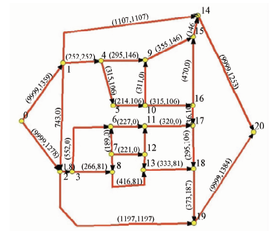
Abstract In order to analyze the influence of traffic network on urban emergency evacuation, the authors studied the vulnerabilities of traffic network and the model of emergency evacuation by GIS spatial analysis. Searching for vulnerable points in road network was conducted by minimal cost maximal flow (MCMF) algorithm. Then the algorithm was evaluated using the road network data in Beijing. Compared with existing software, the proposed method based on GIS platform extracts the road network vulnerabilities more accurately, and it also increases the utilization of the road network in the emergency evacuation and speed up the evacuation.
|
| Keywords
GIS
traffic network model
emergency evacuation
vulnerability
MCMF
|
|
|
|
Corresponding Authors:
Qiming QIN
E-mail: qmqin@pku.edu.cn
|
|
Issue Date: 14 March 2019
|
|
|
| [1] |
Hans J M, Sell T C . Evacuation Risks-An Evaluation[R]. Washington,D.C.US Environmental Protection Agency, 1974.
|
| [2] |
Voorhees A M . Evacuation Times Assessment for the Diablo Canyon Nuclear Power Plant[R]. Pacific Gas and Electric Company, 1980.
|
| [3] |
Sheffi Y . Evacuation studies for nuclear power plant sites:A new challenge for transportation engineers[J]. Institute of Transportation Ergineers, 1981,35(6):2528-2535.
|
| [4] |
Hobeika A G, Kim C . Comparison of traffic assignments in evacuation modeling[J]. IEEE Transactions on Engineering Management, 1998,45(2):192-198.
doi: 10.1109/17.669768
url: http://ieeexplore.ieee.org/document/669768/
|
| [5] |
袁媛, 汪定伟 , 灾害扩散实时影响下的应急疏散路径选择模型[J]. 系统仿真学报, 2008,20(6):1563-1566.
url: http://www.cqvip.com/Main/Detail.aspx?id=26859935
|
| [5] |
Yuan Y, Wang D W . Route selection model in emergency evacuation under real time effect of disaster extension[J]. Journal of System Simulation, 2008,20(6):1563-1566.
|
| [6] |
张培红, 陈宝智, 卢兆明 . 人员应急疏散行动开始前的决策行为[J]. 公路交通科技, 2008,25(9):154-158.
doi: 10.3321/j.issn:1005-3026.2005.02.021
url: http://d.wanfangdata.com.cn/Periodical/dbdxxb200502021
|
| [6] |
Zhang P H, Chen B Z, Lu Z M . Personal decision behavior before emergency evacuation[J]. Journal of Northeastern University(Natural Science), 2008,25(9):154-158.
|
| [7] |
谢素华 . 论我国公路交通应急及运输保障体系的建设[J]. 公路交通科技, 2008,26(2):179-182.
doi: 10.3969/j.issn.1002-0268.2008.09.031
url: http://www.cnki.com.cn/Article/CJFDTotal-GLJK200809030.htm
|
| [7] |
Xie S H . Study on emergency response and transport organization system between China and developed countries[J]. Journal of Northeastern University(Natural Science), 2008,26(2):179-182.
|
| [8] |
刘小明, 胡红 . 应急交通疏散研究现状与展望[J]. 交通运输工程学报, 2008,8(3):14.
doi: 10.3321/j.issn:1671-1637.2008.03.023
url: http://d.wanfangdata.com.cn/Periodical/jtysgcxb200803023
|
| [8] |
Liu X M, Hu H . Research status and prospect of emergency transportation evacuation[J]. Journal of Traffic and Transportation Engineering, 2008,8(3):14.
|
| [9] |
宋永朝, 潘晓东, 杨轸 , 等. 灾害事件下局域路网应急疏散交通分配模型[J]. 公路交通科技, 2010,27(5):88-92.
doi: 10.3969/j.issn.1002-0268.2010.05.018
url: http://www.cqvip.com/Main/Detail.aspx?id=33739854
|
| [9] |
Song Y C, Pan X D, Yang Z , et al. Traffic assignment model of emergency evacuation in local network against disaster affairs[J]. Journal of Highway and Transportation Research and Development, 2010,27(5):88-92.
|
| [10] |
尹洪英, 徐丽群 . 道路交通网络脆弱性评估研究现状与展望[J]. 交通运输系统工程与信息, 2010,10(3):7-13.
doi: 10.3969/j.issn.1009-6744.2010.03.002
url: http://d.wanfangdata.com.cn/Periodical/jtysxtgcyxx201003002
|
| [10] |
Yin H Y, Xu L Q . Vulnerability assessment of transportation road networks[J]. Journal of Transportation Systems Engineering and Information Technology, 2010,10(3):7-13.
|
| [11] |
陈岳明, 萧德云 . 路网应急疏散问题建模及其应用的进展[J]. 科学技术与工程, 2008,20(6):1563-4950.
doi: 10.3969/j.issn.1671-1815.2008.17.037
url: http://d.wanfangdata.com.cn/Periodical/kxjsygc200817037
|
| [11] |
Chen Y M, Xiao D Y . Review of evacuation modeling in emergency and its application.[J]. Scinece Technology and Engineering, 2008,20(6):1563-4950.
|
| [12] |
袁建平, 方正, 卢兆明 . 城市灾时大范围人员应急疏散探讨[J]. 自然灾害学报, 2005,14(6):116-119.
doi: 10.3969/j.issn.1004-4574.2005.06.021
url: http://www.cnki.com.cn/Article/CJFDTotal-ZRZH200506020.htm
|
| [12] |
Yuan J P, Fang Z, Lu Z M . Large-scale evacuation of people from urban disaster.[J]. Journal of Natural Disasters, 2005,14(6):116-119.
|
| [13] |
韩伯棠 . 管理运筹学[M]. 北京: 高等教育出版社, 2010.
|
| [13] |
Han B T.Management Operational Research.[M]. Beijing: Higher Education Press, 2010.
|
|
Viewed |
|
|
|
Full text
|
|
|
|
|
Abstract
|
|
|
|
|
Cited |
|
|
|
|
| |
Shared |
|
|
|
|
| |
Discussed |
|
|
|
|
 2019,
Vol. 31
2019,
Vol. 31