|
|
 |
|
|
|
|
Characteristics of GIS applications in national fitness |
WANG Shuang1( ), ZHANG Lei2,3(), ZHANG Junyong2, WANG Yile4 ), ZHANG Lei2,3(), ZHANG Junyong2, WANG Yile4 |
1. Physical Education College, Zhengzhou University, Zhengzhou 450000, China
2. School of Physical Education, Zhengzhou University, Zhengzhou 450001, China
3. Postdoctoral Research Station of Marxist Theory, Zhengzhou University, Zhengzhou 450001, China
4. School of Sport, Nanyang Normal University, Nanyang 473061, China |
|
|
|
|
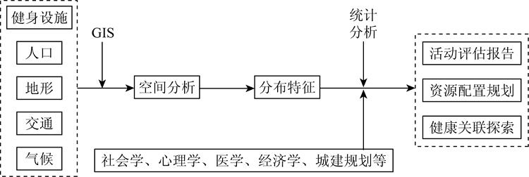
Abstract With the in-depth development of the national fitness movement in China, the public’s health awareness has significantly increased, but sports and fitness facilities have gradually been unable to meet the people’s growing need for fitness. Based on the review and summary of the historical development, application scope, and application means of the geographic information system (GIS) technology in national fitness, this paper concludes that the GIS is primarily applied to the spatial data analysis, the resource allocation of fitness facilities, and the query and retrieval of fitness information in the field of national fitness by means of the spatial distribution characteristics analysis, accessibility assessment, and correlation verification of national fitness facilities. The GIS technology can efficiently address the issues concerning the layout of sports and fitness facilities, thus facilitating physical exercise activities of the public and significantly improving the effects of national fitness activities. Furthermore, the GIS technology will provide more effective technical support for national fitness activities in the scientific and technological progress and the development of multidisciplinary research.
|
| Keywords
GIS
national fitness
spatial distribution
accessibility
application characteristics
|
|
|
|
Corresponding Authors:
ZHANG Lei
E-mail: 25498187@qq.com;zhlei0379@zzu.edu.cn
|
|
Issue Date: 23 December 2021
|
|
|
| [1] |
国务院. 关于实施健康中国行动的意见[EB/OL].(2019-07-15)[2021-01-08]. http://www.gov.cn/zhengce/content/2019-07/15/content_5409492.htm.
url: http://www.gov.cn/zhengce/content/2019-07/15/content_5409492.htm
|
| [1] |
State Council’s General Office. State council measures to enhance people’s fitness,health[EB/OL].(2019-07-15)[2021-01-08]. http://www.gov.cn/zhengce/content/2019-07/15/content_5409492.htm.
url: http://www.gov.cn/zhengce/content/2019-07/15/content_5409492.htm
|
| [2] |
国务院. 关于加强全民健身场地设施建设发展群众体育的意见[EB/OL].(2020-10-10)[2021-01-08]. http://www.gov.cn/zhengce/content/2020-10/10/content_5550053.htm.
url: http://www.gov.cn/zhengce/content/2020-10/10/content_5550053.htm
|
| [2] |
State Council’s General Office. China to boost mass fitness with more facility construction[EB/OL].(2020-10-10)[2021-01-08]. http://www.gov.cn/zhengce/content/2020-10/10/content_5550053.htm.
url: http://www.gov.cn/zhengce/content/2020-10/10/content_5550053.htm
|
| [3] |
国家体育总局. 2014年全民健身活动状况调查公报[EB/OL].(2015-11-16)[2021-01-08]. http://www.sport.gov.cn/n16/n1077/n1422/7300210.html.
url: http://www.sport.gov.cn/n16/n1077/n1422/7300210.html
|
| [3] |
General Administration of Sport of China. 2014 National fitness survey communique[EB/OL].(2015-11-16)[2021-01-08]. http://www.sport.gov.cn/n16/n1077/n1422/7300210.html.
url: http://www.sport.gov.cn/n16/n1077/n1422/7300210.html
|
| [4] |
林海, 施璐. 基于GIS空间分析的城市公共体育设施空间优化整合研究——以沈阳市为例[J]. 沈阳体育学院学报, 2019,38(5):41-46,76.
|
| [4] |
Lin H, Shi L. Optimization and integration of urban public sports facilities space based on GIS spatial analysis:A case study of Shenyang City[J]. Journal of Shenyang Sport University, 2019,38(5):41-46,76.
|
| [5] |
郑新奇, 阎弘文, 赵涛. RS和GIS支持的城市土地优化配置——以济南市为例[J]. 国土资源遥感, 2001,47(1):15-18,53.doi: 10.6046/gtzyyg.2001.01.03.
doi: 10.6046/gtzyyg.2001.01.03
|
| [5] |
Zheng X Q, Yan H W, Zhao T. Study on optimal disposition of urban land based on RS and GIS[J]. Remote Sensing for Land and Resources, 2001,47(1):15-18,53.doi: 10.6046/gtzyyg.2001.01.03.
doi: 10.6046/gtzyyg.2001.01.03
|
| [6] |
Chang K T. 地理信息系统导论(第8版)[M].陈健飞,等译. 北京: 科学出版社, 2019.
|
| [6] |
Chang K T. Introduction to geographic information systems[M].Translated by Chen J F,et al. Beijing: Science Press, 2019.
|
| [7] |
Classen R J. An introduction to geographic information systems[J]. Computers & Industrial Engineering, 1977,1(2):131-138.
doi: 10.1016/0360-8352(77)90015-8
url: https://linkinghub.elsevier.com/retrieve/pii/0360835277900158
|
| [8] |
Levine J, Landis J D, Klosterman R. Geographic information systems for local planning[J]. Journal of the American Planning Association, 1989,55(2):209-220.
doi: 10.1080/01944368908976022
url: http://www.tandfonline.com/doi/abs/10.1080/01944368908976022
|
| [9] |
林显鹏, 刘云发. 国外社区体育中心的建设与经营管理研究——兼论我国体育场馆建设与发展思路[J]. 体育科学, 2005,25(12):12-16,27.
|
| [9] |
Lin X P, Liu Y F. Study on construction and management of community sport centers in foreign countries[J]. China Sport Science, 2005,25(12):12-16,27.
|
| [10] |
李艳霞, 傅学庆, 郝军龙. 基于GIS的全民健身路径空间布局分析[J]. 河北师范大学学报(自然科学版), 2008,32(1):123-127,132.
|
| [10] |
Li Y X, Fu X Q, Hao J L. Analysis of the space character of health establishment-spot of people in the city of Shijiazhuang[J]. Journal of Hebei Normal University(Natural Science Edition), 2008,32(1):123-127,132.
|
| [11] |
胡精超, 王莉. 基于GIS的城市公共体育服务设施选址优化研究[J]. 哈尔滨体育学院学报, 2013,31(4):10-15.
|
| [11] |
Hu J C, Wang L. Optimizing the distribution of city public sports service facilities based on GIS[J]. Journal of Harbin Sport University, 2013,31(4):10-15.
|
| [12] |
杜长亮, 顾校飞, 李南. 社区公共体育设施选址规划研究[J]. 中国体育科技, 2016,52(3):13-20.
|
| [12] |
Du C L, Gu X F, Li N. Research on facilities location planning of community sports[J]. China Sport Science and Technology, 2016,52(3):13-20.
|
| [13] |
Lee D T, Lee Y S, Son Y S, et al. Associations between recreational space and sport facilities of GIS and health related variable in middle-aged community residents[J]. Journal of the Korean society for Wellness, 2012,7(1):297-307.
|
| [14] |
Lee W K, Heo C K, Kim H R. Effect of public sports facilities on obesity rate and physical activity rate of local community using GIS & spatial statistics[J]. Korean Journal of Sports Science, 2018,27(4):1067-1080.
doi: 10.35159/kjss.2018.08.27.4.1067
url: http://www.dbpia.co.kr/Journal/ArticleDetail/NODE07523034
|
| [15] |
国家体育总局. 第六次全国体育场地普查数据公报[EB/OL].(2014-12-26)[2021-01-08]. http://www.sport.gov.cn/n16/n1077/n1467/n3895927/n4119307/7153937.html.
url: http://www.sport.gov.cn/n16/n1077/n1467/n3895927/n4119307/7153937.html
|
| [15] |
General Administration of Sport of China. Data bulletin of the sixth national census of sports sites[EB/OL].(2014-12-26)[2021-01-08]. http://www.sport.gov.cn/n16/n1077/n1467/n3895927/n4119307/7153937.html.
url: http://www.sport.gov.cn/n16/n1077/n1467/n3895927/n4119307/7153937.html
|
| [16] |
董新光. 论公共体育资源配置的不平衡及改革取向[J]. 体育文化导刊, 2007(3):6-11.
|
| [16] |
Dong X G. On the imbalance and reform orientation of public sports resources[J]. Sports Culture Guide, 2007(3):6-11.
|
| [17] |
杜金龙, 朱记伟, 解建仓, 等. 基于GIS的城市土地利用研究进展[J]. 国土资源遥感, 2018,30(3):9-17.doi: 10.6046/gtzyyg.2018.03.02.
doi: 10.6046/gtzyyg.2018.03.02
|
| [17] |
Du J L, Zhu J W, Xie J C, et al. An overview of urban land use research based on GIS[J]. Remote Sensing for Land and Resources, 2018,30(3):9-17.doi: 10.6046/gtzyyg.2018.03.02.
doi: 10.6046/gtzyyg.2018.03.02
|
| [18] |
陈旸. 基于GIS的社区体育服务设施布局优化研究[J]. 经济地理, 2010,30(8):1254-1258.
|
| [18] |
Chen Y. Optimizing the distribution of community sports service facilities based on GIS[J]. Economic Geography, 2010,30(8):1254-1258.
|
| [19] |
Kim J, Thapa B, Jang S. GPS-based mobile exercise application:An alternative tool to assess spatio-temporal patterns of visitors’ activities in a national park[J]. Journal of Park & Recreation Administration, 2019,37(1):124-134.
|
| [20] |
董德朋, 袁雷, 韩义. 基于ArcGIS的城市中心城区公共体育服务空间:结构、问题与策略——以长春市为例[J]. 上海体育学院学报, 2017,41(6):10-16.
|
| [20] |
Dong D P, Yuan L, Han Y. ArcGIS-based public sport service space in the urban center:Structure,problems and strategies-A case study of Changchun[J]. Journal of Shanghai University of Sport, 2017,41(6):10-16.
|
| [21] |
宫彩燕, 刘志国. 全民健身路径工程与市民健身需求的契合研究——以烟台市区为例[J]. 安徽体育科技, 2018,39(4):60-63.
|
| [21] |
Gong C Y, Liu Z G. A comparative study on the national fitness route project and citizens’ fitness need-take Yantai City as the example[J]. Journal of Anhui Sports Science, 2018,39(4):60-63.
|
| [22] |
张欣. 基于地理信息技术的城市公共体育设施服务辐射能力分析[J]. 沈阳体育学院学报, 2012,31(2):35-38.
|
| [22] |
Zhang X. Radiation ability of urban public sports facilities service based on GIS[J]. Journal of Shenyang Sport University, 2012,31(2):35-38.
|
| [23] |
马冬雪, 江芸, 朱明勇. 基于GIS的中国体育非物质文化遗产空间分布研究[J]. 体育科学, 2015,35(6):19-24.
|
| [23] |
Ma D X, Jiang Y, Zhu M Y. Study on the distribution of sports intangible cultural heritage in China based on GIS[J]. China Sport Science, 2015,35(6):19-24.
|
| [24] |
刘贤腾. 空间可达性研究综述[J]. 城市交通, 2007,5(6):36-43.
|
| [24] |
Liu X T. General description of spatial accessibility[J]. Urban Transport of China, 2007,5(6):36-43.
|
| [25] |
陈婷婷, 魏宗财, 陈卓源. 城市居民健身场所布局公平性及优化对策[J]. 规划师, 2015,31(7):17-23.
|
| [25] |
Chen T T, Wei Z C, Chen Z Y. Spatial equality of fitness facilities and improvement[J]. Planners, 2015,31(7):17-23.
|
| [26] |
金银日, 姚颂平, 刘东宁. 基于GIS的上海市公共体育设施空间可达性与公平性评价[J]. 上海体育学院学报, 2017,41(3):42-47.
|
| [26] |
Jin Y R, Yao S P, Liu D N. GIS-based spatial accessibility and equity evaluation of urban public sports facilities in Shanghai[J]. Journal of Shanghai University of Sport, 2017,41(3):42-47.
|
| [27] |
蔚芳, 王鑫. 基于2SFCA法的杭州体育活力空间可达性评价[J]. 城市规划, 2019,43(11):112-119.
|
| [27] |
Wei F, Wang X. Measuring spatial accessibility to physical activity spaces in Hangzhou using 2SFCA method[J]. City Planning Review, 2019,43(11):112-119.
|
| [28] |
宋正娜, 陈雯, 张桂香, 等. 公共服务设施空间可达性及其度量方法[J]. 地理科学进展, 2010,29(10):1217-1224.
doi: 10.11820/dlkxjz.2010.10.009
|
| [28] |
Song Z N, Chen W, Zhang G X, et al. Spatial accessibility to public service facilities and its measurement approaches[J]. Progress in Geography, 2010,29(10):1217-1224.
|
| [29] |
彭菁, 罗静, 熊娟, 等. 国内外基本公共服务可达性研究进展[J]. 地域研究与开发, 2012,31(2):20-25.
|
| [29] |
Peng J, Luo J, Xiong J, et al. Review of domestic and foreign research on the basic public service accessibiliy[J]. Areal Research and Development, 2012,31(2):20-25.
|
| [30] |
曾远文, 丁忆, 胡艳, 等. 农村居民点空间布局及优化分析——以重庆市合川区狮滩镇聂家村为例[J]. 国土资源遥感, 2018,30(3):113-119.doi: 10.6046/gtzyyg.2018.03.16.
doi: 10.6046/gtzyyg.2018.03.16
|
| [30] |
Zeng Y W, Ding Y, Hu Y, et al. An analysis of spatial distribution and optimization of rural settlements:A case study of Niejia Village in Shitan Town,Hechuan District,Chongqing[J]. Remote Sensing for Land and Resources, 2018,30(3):113-119.doi: 10.6046/gtzyyg.2018.03.16.
doi: 10.6046/gtzyyg.2018.03.16
|
| [31] |
何静, 周典, 徐怡珊, 等. 城市社区养老设施空间可达性度量方法研究[J]. 建筑学报, 2018(s1):18-22.
|
| [31] |
He J, Zhou D, Xu Y S, et al. The study on spatial accessibility measurement of pension facilities in urban community[J]. Architectural Journal, 2018(s1):18-22.
|
| [32] |
徐侃. 基于GIS的社区公共体育设施可达性研究——以杭州市城西为例[D]. 杭州:浙江工业大学, 2017.
|
| [32] |
Xu K. Analysis of the accessibility of community sports facilities based on GIS——Take Hangzhou City west as an example[D]. Hangzhou:Zhejiang University of Technology, 2017.
|
| [33] |
Polzin P, Borges J, Coelho A. An extended kernel density two-step floating catchment area method to analyze access to Health Care[J]. Environment and Planning B:Planning and Design, 2014,41(4):717-735.
doi: 10.1068/b120050p
url: http://journals.sagepub.com/doi/10.1068/b120050p
|
| [34] |
Donthu N, Rust R T. Note-estimating geographic customer densities using kernel density estimation[J]. Marketing Science, 1989,8(2):191-203.
doi: 10.1287/mksc.8.2.191
url: http://pubsonline.informs.org/doi/abs/10.1287/mksc.8.2.191
|
| [35] |
Lee C K, Lee S G. Analysis of the impacts of neighborhood environment on physical activity and health status in Seoul,Korea[J]. Journal of Korea Planning Association, 2016,51(3):217-239.
doi: 10.17208/jkpa.2016.06.51.3.217
url: http://kpaj.or.kr/_common/do.php?a=full&bidx=535&aidx=6652
|
| [36] |
Besenyi G M. Park environments and youth physical activity:Exploring the influence of proximity and features across Kansas City Missouri[D]. Kansas:Kansas State University, 2003.
|
| [37] |
Hamilton K L. Park usage and physical activity:An exploration of park features,neighbourhoods,and park program[D]. Ontario:Queen’s University, 2011.
|
| [38] |
Bemdio-Rung A L, Mowen A J, Cohen D A. The significance of parks to physical activity and public health[J]. American Journal of Preventive Medicine, 2005,28(s2):159-168.
doi: 10.1016/j.amepre.2004.10.024
url: https://linkinghub.elsevier.com/retrieve/pii/S0749379704003046
|
| [39] |
Chun Y I, Shin Y H. Utilization methods of geographic information system(GIS) for the activation of marketing for sports centers[J]. Journal of Sport and Leisure Studies, 2002,18(1):447-458.
doi: 10.51979/KSSLS.2002.11.18.447
url: http://www.dbpia.co.kr/Journal/ArticleDetail/NODE06242755
|
| [40] |
Greg B, Morgan F S, Delene W. Using participatory GIS to measure physical activity and urban park benefits[J]. Landscape and Urban Planning, 2014,121:34-44.
doi: 10.1016/j.landurbplan.2013.09.006
url: https://linkinghub.elsevier.com/retrieve/pii/S0169204613001850
|
|
Viewed |
|
|
|
Full text
|
|
|
|
|
Abstract
|
|
|
|
|
Cited |
|
|
|
|
| |
Shared |
|
|
|
|
| |
Discussed |
|
|
|
|
 2021,
Vol. 33
2021,
Vol. 33