|
|
 |
|

|
|
|
Influence of urban rivers and their surrounding land on the surface thermal environment |
FENG Xiaogang1( ), ZHAO Yi2, LI Meng1, ZHOU Zaihui1, LI Fengxia1, WANG Yuan1, YANG Yongquan3 ), ZHAO Yi2, LI Meng1, ZHOU Zaihui1, LI Fengxia1, WANG Yuan1, YANG Yongquan3 |
1. College of Architecture, Xi’an University of Architecture and Technology, Xi’an 710055, China
2. CCC Urban and Rural Construction Planning and Design Institute, Wuhan 430050, China
3. Shandong Province Metallurgical Engineering Co., Ltd., Jinan 250101, China |
|
|
|
|
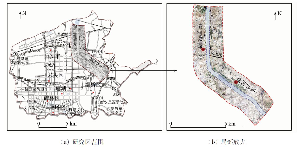
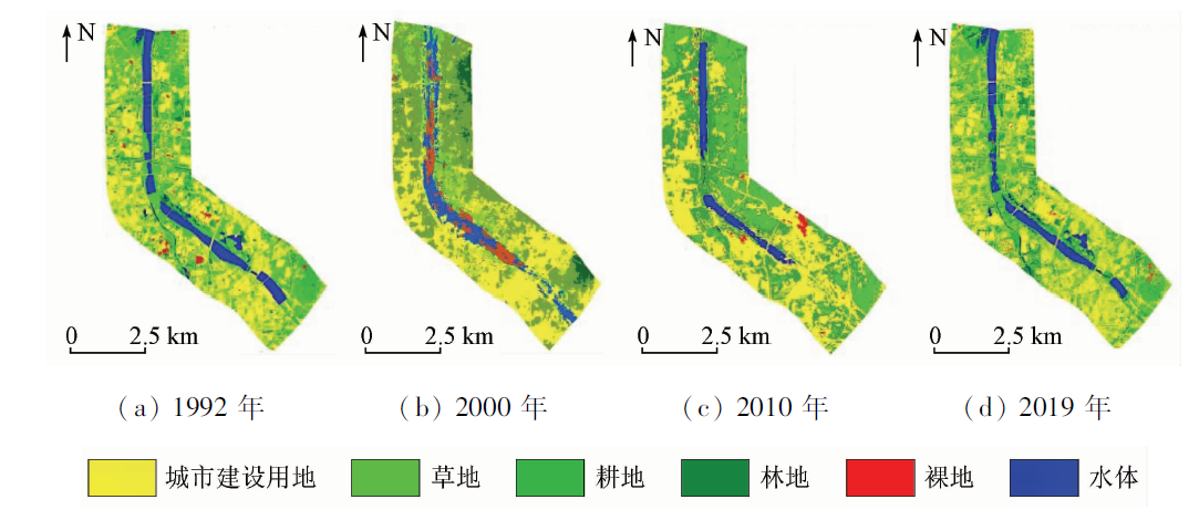
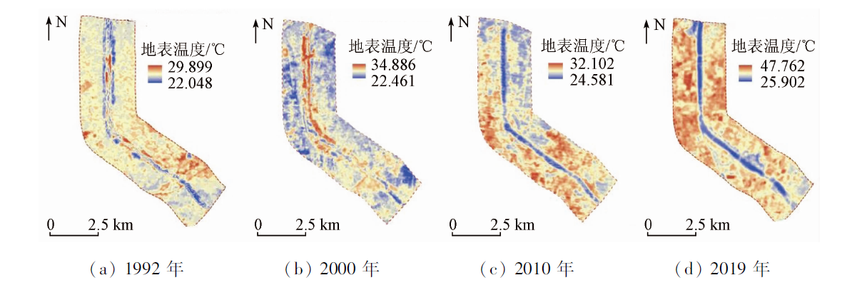
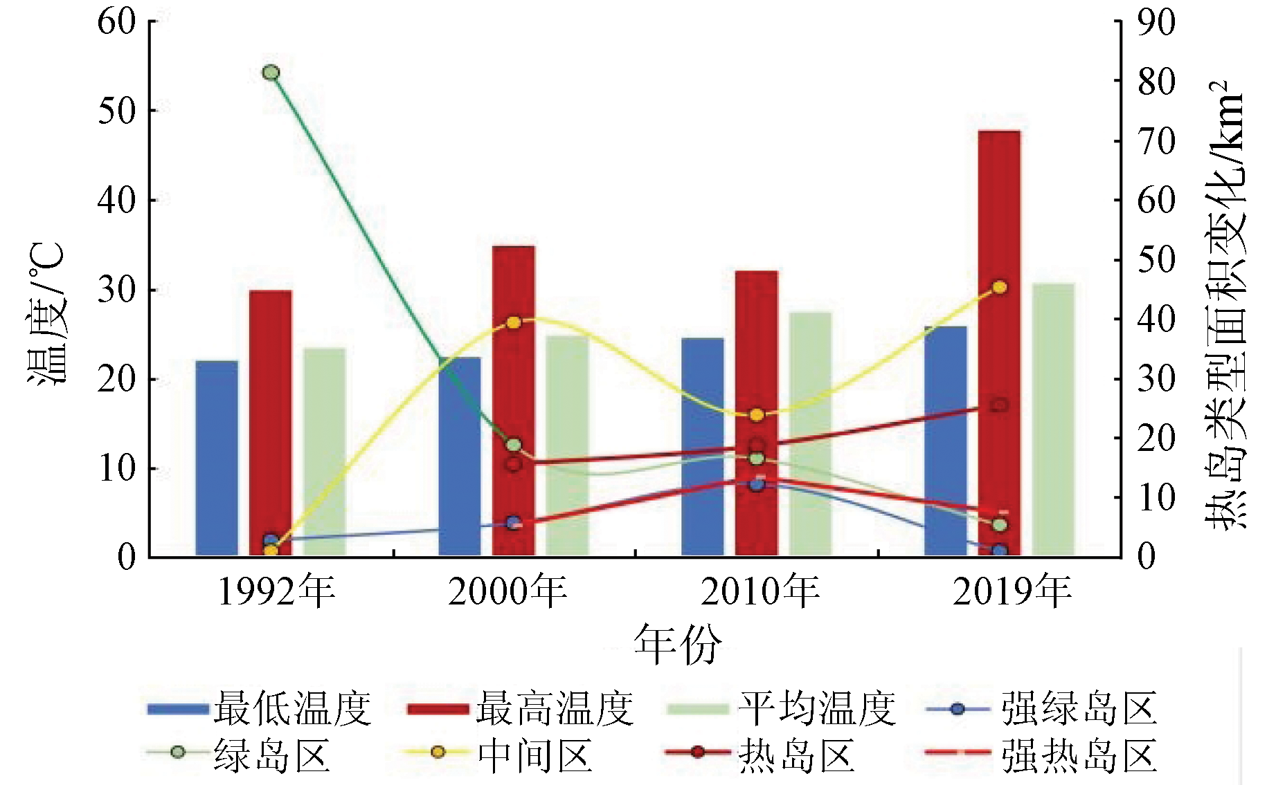
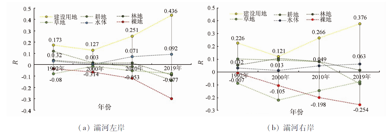
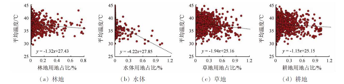
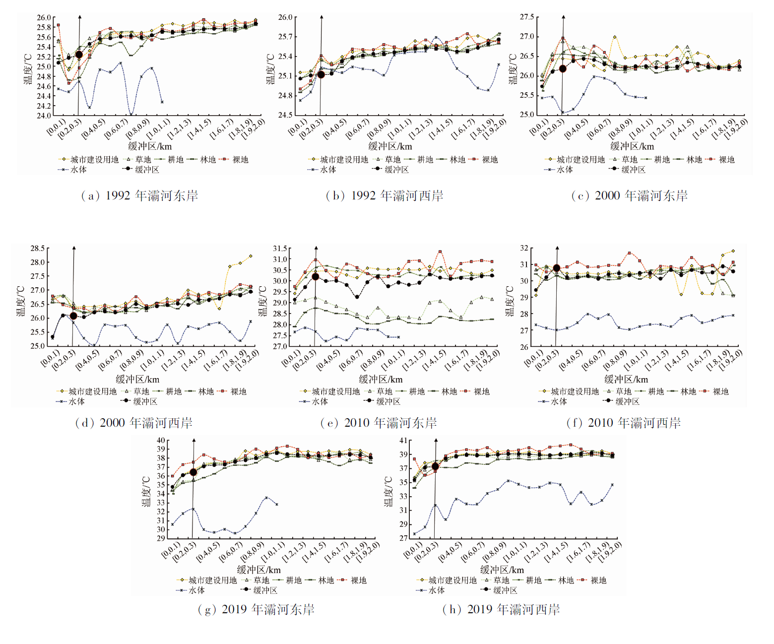
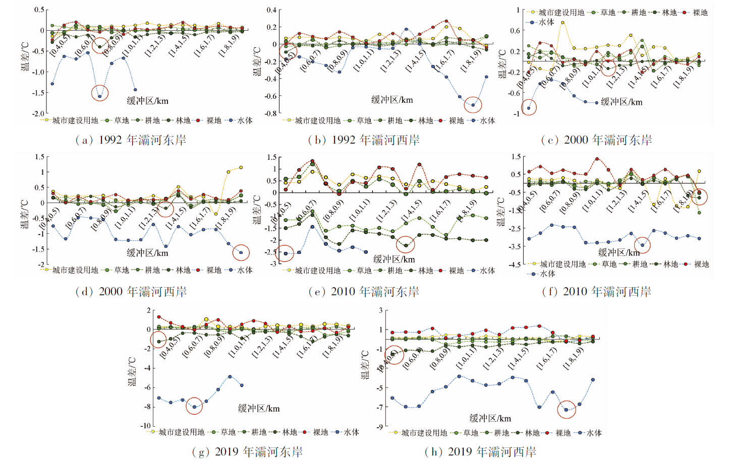
Abstract As an integral component of the urban ecosystem, water bodies hold considerable ecological significance for mitigating the urban heat island effect and the thermal environment of human habitat. With multi-temporal Landsat and SPOT data as experimental data, this study proposed a method for determining surface emissivity for mixed pixels based on the principle behind the construction of the support vector machine (SVM) optimal endmember subset. Then, this study employed the surface emissivity determination method to analyze the coupling relationship of the water bodies and surrounding land of the Bahe River with the surface temperature using a mono-window algorithm. The results are as follows: ① The SVM optimal endmember subset construction method for mixed pixels yielded an error of surface emissivity less than 0.005 (R = 0.832) relative to the MODIS LSE product. This result indicates that the method has high accuracy and thus can be used to extract surface emissivity. ② Over the past 27 years, the land types and local surface temperature patterns on both sides of the Bahe River have changed significantly, with a sharp increase in construction land and a significant warming trend. The effects of land use types surrounding the Bahe River on surface temperature varied in different periods, with construction land, grassland, water bodies, and forest land being the principal land use types affecting the thermal environment on both sides of the Bahe River. The cooling effects of water bodies, forest land, grassland, and cultivated land are in the order of water bodies > forest land > grassland > cultivated land. ③ The effects of land use types on both sides of the Bahe River on local temperatures exhibited spatial differences during the same period. To the east of the Bahe River, the water bodies, forest land, grassland, and cultivated land show significant cooling effects. In contrast, to the west of the river, only water bodies, forest land, and grassland showed significant cooling effects. This study contributes to the proper understanding of the influence of urban rivers on the local thermal environment, providing a scientific reference for mitigating the local thermal environment of urban rivers and their surrounding areas.
|
| Keywords
surface emissivity
thermal environment
urban heat island effect
water body
Bahe River
|
|
|
|
Issue Date: 19 September 2023
|
|
|
| [1] |
姚远, 陈曦, 钱静. 城市地表热环境研究进展[J]. 生态学报, 2018, 38(3):1134-1147.
|
| [1] |
Yao Y, Chen X, Qian J. Research progress on the thermal environment of the urban surface[J]. Acta Ecologica Sinica, 2018, 38(3):1134-1147.
|
| [2] |
冯晓刚, 周在辉, 李凤霞, 等. 西咸一体化驱动的咸阳市热力景观格局时空分异分析[J]. 西安建筑科技大学学报(自然科学版), 2021, 53(3):413-420.
|
| [2] |
Feng X G, Zhou Z H, Li F X, et al. Spatiotemporal differentiation of thermal landscape pattern in Xianyang City driven by the integration of Xi’an and Xianyang[J]. Journal Xi’an University of Architecture and Technology (Natural Science Edition), 2021, 53(3): 413-420.
|
| [3] |
岳文泽, 徐丽华. 城市典型水域景观的热环境效应[J]. 生态学报, 2013, 33(6):1852-1859.
|
| [3] |
Yue W Z, Xu L H. Thermal environment effect of urban water landscape[J]. Acta Ecologica Sinica, 2013, 33(6): 1852-1859.
doi: 10.5846/stxb
url: http://www.ecologica.cn/
|
| [4] |
冯悦怡, 胡潭高, 张力小. 城市公园景观空间结构对其热环境效应的影响[J]. 生态学报, 2014, 34(12):3179-3187.
|
| [4] |
Feng Y Y, Hu T G, Zhang L X. Impacts of structure characteristics on the thermal environment effect of city parks[J]. Acta Ecologica Sinica, 2014, 34(12):3179-3187.
|
| [5] |
Lin Y, Wang Z F, Yang C, et al. Water as an urban heat sink: Blue infrastructure alleviates urban heat island effect in mega-city agglomeration[J]. Journal of Cleaner Production, 2020, 262:1-8.
|
| [6] |
Tan X Y, Sun X, Huang C D, et al. Comparison of cooling effect between green space and water body[J]. Sustainable Cities and Society, 2021, 67:1-11.
|
| [7] |
梁保平, 马艺芳, 李晖. 桂林市典型园林绿地与水体的降温效应研究[J]. 生态环境学报, 2015, 24(2):278-285.
doi: 10.16258/j.cnki.1674-5906.2015.02.015
|
| [7] |
Liang B P, Ma Y F, Li H. Research on colling effect of landscape green space and urban water in Guilin City[J]. Ecology and Environmental Sciences, 2015, 24(2):278-285.
|
| [8] |
Du H Y, Song X J, Jiang H, et al. Research on the cooling island effects of water body: A case study of Shanghai,China[J]. Ecological Indicators, 2016, 67:31-38.
doi: 10.1016/j.ecolind.2016.02.040
url: https://linkinghub.elsevier.com/retrieve/pii/S1470160X16300619
|
| [9] |
Wu J S, Li C M, Zhang X, et al. Seasonal variations and main influencing factors of the water cooling islands effect in Shenzhen[J]. Ecological Indicators, 2020, 17:1470.
|
| [10] |
曾素平, 时琢, 赵梅芳, 等. 城市水体对热岛的缓冲性能沿河岸距离的变化规律[J]. 生态学报, 2020, 40(15):5190-5202.
|
| [10] |
Zeng S P, Shi Z, Zhao M F, et al. The variation of buffer performance of water bodies on urban heat island along riverbank distance[J]. Acta Ecologica Sinica, 2020, 40(15): 5190-5202.
|
| [11] |
张伟, 王凯丽, 梁胜, 等. 基于计算力流体力学的城市近郊湖泊“冷岛效应”及其情景模拟研究——以长沙市同升湖为例[J]. 生态环境学报, 2021, 30(10):2054-2066.
doi: 10.16258/j.cnki.1674-5906.2021.10.012
|
| [11] |
Zhang W, Wang K L, Liang S, et al. Research on the “Cold Island Effect” and scenario simulation of lakes in urban suburbs based on computational force fluid dynamics: Taking Tongsheng Lake in Changsha City as an example[J]. Ecology and Environmental Sciences, 2021, 30(10):2054-2066.
|
| [12] |
Zheng Y, Li Y, Hou H, et al. Quantifying the cooling effect and scale of large inner-city lakes based on landscape patterns: A case study of Hangzhou and Nanjing[J]. Remote Sensing, 2021, 13(8): 1526.
doi: 10.3390/rs13081526
url: https://www.mdpi.com/2072-4292/13/8/1526
|
| [13] |
张晓东, 赵银鑫, 马风华, 等. 基于遥感数据的银川市城市公园对城市热环境降温效应分析[J]. 水土保持通报, 2021, 41(5):338-347.
|
| [13] |
Zhang X D, Zhao Y X, Ma F H, et al. Analysis on cooling effect of urban parks on urban thermal environment in Yinchuan City based on remote sensing[J]. Bulletin of Soil and Water Conservation, 2021, 41(5):338-347.
|
| [14] |
王耀斌, 赵永华, 韩磊, 等. 西安市景观格局与城市热岛效应的耦合关系[J]. 应用生态学报, 2017, 28(8):2621-2628.
|
| [14] |
Wang Y B, Zhao Y H, Han L, et al. Coupling relationship of landscape pattern and urban heat island effect in Xi’an,China[J]. Chinese Journal of Applied Ecology, 2017, 28(8):2621-2628.
|
| [15] |
胡李发, 谢元礼, 崔思颖, 等. 关中平原城市群夏季城市热岛特征及驱动力[J]. 中国环境科学, 2021, 41(8): 3842-3852.
|
| [15] |
Hu L F, Xie Y L, Cui S Y, et al. The characteristics and driving forces of summer urban island in Guanzhong Plain urban agglomeration[J]. China Environmental Science, 2021, 41(8):3842-3852.
|
| [16] |
黄路, 邵浩, 张彩云, 等. 用辐射传输方程改进算法反演Landsat8海表温度的效果检验和适用条件分析[J]. 应用海洋学学报, 2021, 40(4):714-720.
|
| [16] |
Huang L, Shao H, Zhang C Y, et al. Radiative transfer equation algorithm to retrieve Landsat8 sea surface temperature[J]. Journal of Applied Oceanography, 2021, 40(4):714-720.
|
| [17] |
段四波, 茹晨, 李召良, 等. Landsat卫星热红外数据地表温度遥感反演研究进展[J]. 遥感学报, 2021, 25(8):1591-1617.
|
| [17] |
Duan S B, Ru C, Li Z L, et al. Reviews of methods for land surface temperature retrieval from Landsat thermal infrared data[J]. National Remote Sensing Bulletin, 2021, 25(8):1591-1617.
doi: 10.11834/jrs.20211296
url: http://www.ygxb.ac.cn/zh/article/doi/10.11834/jrs.20211296/
|
| [18] |
覃志豪, Zhang M H, Arnon K, 等. 用陆地卫星TM6数据演算地表温度的单窗算法[J]. 地理学报, 2001(4):456-466.
doi: 10.11821/xb200104009
|
| [18] |
Qin Z H, Zhang M H, Arnon K, et al. Mono-window algorithm for retrieving land surface land temperature from Landsat TM6 data[J]. Acta Geo-Graphica Sinica, 2001(4):456-466.
|
| [19] |
覃志豪, 李文娟, 徐斌, 等. 利用Landsat TM6反演地表温度所需地表辐射率参数的估计方法[J]. 海洋科学进展, 2004(22):129-137.
|
| [19] |
Qin Z H, Li W J, Xu B, et al. Estimation method of land surface emissivity for retrieving land surface temperature from Landsat TM6 data[J]. Advances in Marine Science, 2004(22):129-137.
|
| [20] |
宋彩英, 覃志豪, 王斐. 基于线性光谱混合模型的地表温度像元分解方法[J]. 红外与毫米波学报, 2015, 34(4):497-504.
|
| [20] |
Song C Y, Qin Z H, Wang F. An effective method for LST decomposition based on the linear spectral mixing model[J]. Journal of Infrared and Millimeter Waves, 2015, 34(4):497-504.
|
| [21] |
徐涵秋. Landsat8热红外数据定标参数的变化及其对地表温度反演的影响[J]. 遥感学报, 2016, 20(2): 229-235.
|
| [21] |
Xu H Q. Change of Landsat8 TIRS calibration parameters and its effect on land surface temperature retrieval[J]. Journal of Remote Sensing, 2016, 20(2): 229-235.
|
| [22] |
周佳, 赵亚鹏, 岳天祥, 等. 结合HASM和GWR方法的省级尺度近地表气温估算[J]. 地球信息科学学报, 2020, 22(10):2098-2107.
doi: 10.12082/dqxxkx.2020.190423
|
| [22] |
Zhou J, Zhao Y P, Yue T X, et al. Near surface air temperature estimation by combining HASM with GWR model on a provincial scale[J]. Journal of Geo-Information Science, 2020, 22(10):2098-2107.
|
| [23] |
韩晟, 韩坚舟, 赵璇, 等. 距离权重改进的Pearson相关系数及应用[J]. 石油地球物理勘探, 2019, 54(6):1363-1370.
|
| [23] |
Han S, Han J Z, Zhao X, et al. A Pearson correlation coefficient improved by spatial weight[J]. Oil Geophysical Prospecting, 2019, 54(6): 1363-1370.
|
| [24] |
凌德泉, 毕硕本, 左颖, 等. 缓冲区分析综合模型构建研究[J]. 测绘科学, 2019, 44(9):47-53.
|
| [24] |
Ling D Q, Bi S B, Zuo Y, et al. Study on the comprehensive model construction of buffer analysis[J]. Science of Surveying and Mapping, 2019, 44(9):47-53.
|
| [25] |
王丽霞, 孙津花, 刘招, 等. 基于Landsat8数据反演地表发射率的几种不同算法对比分析[J]. 西安科技大学学报, 2019, 39(2):327-333.
|
| [25] |
Wang L X, Sun J H, Liu C, et al. Comparison of several different algorithms to retrieve land surface emissivity using Landsat8 data[J]. Journal of Xi’an University of Science and Technology, 2019, 39(2):327-333.
|
|
Viewed |
|
|
|
Full text
|
|
|
|
|
Abstract
|
|
|
|
|
Cited |
|
|
|
|
| |
Shared |
|
|
|
|
| |
Discussed |
|
|
|
|
 2023,
Vol. 35
2023,
Vol. 35