|
|
|
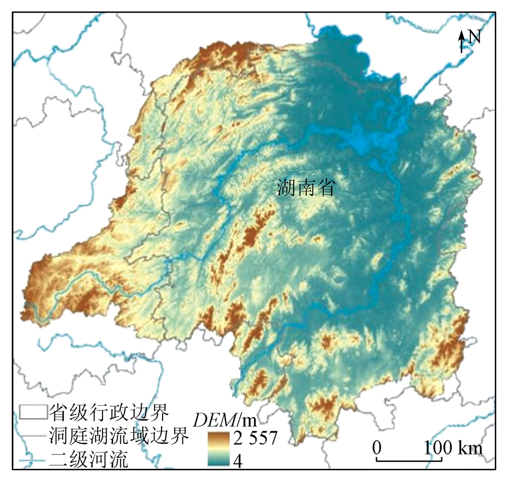
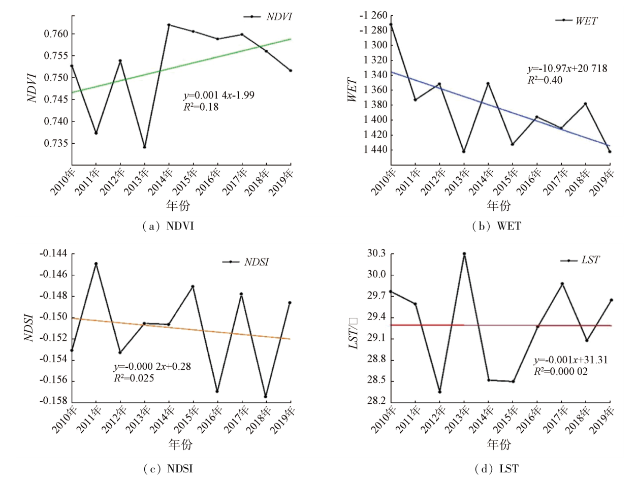
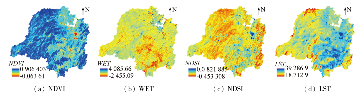
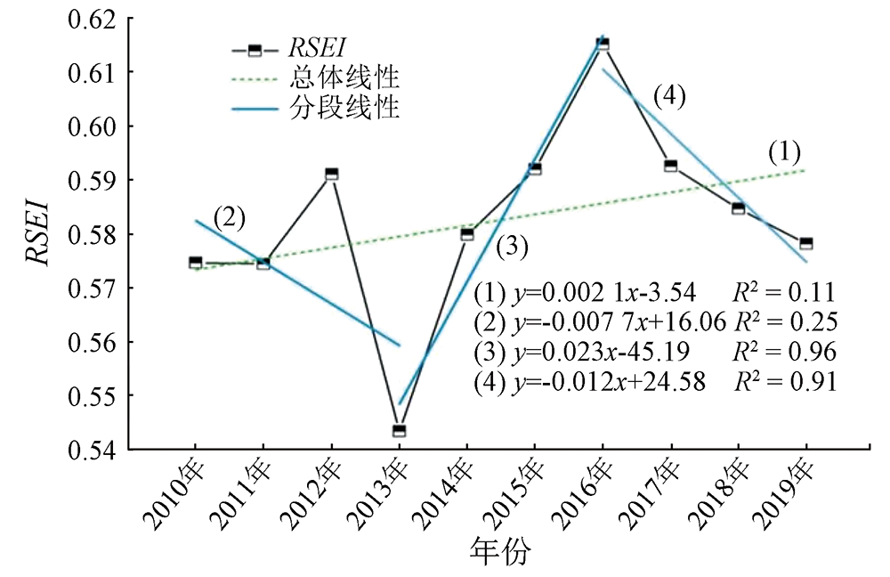
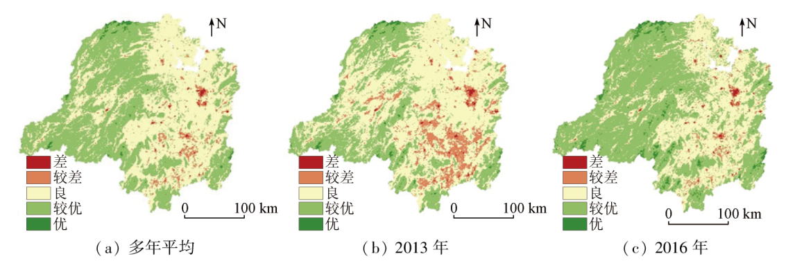
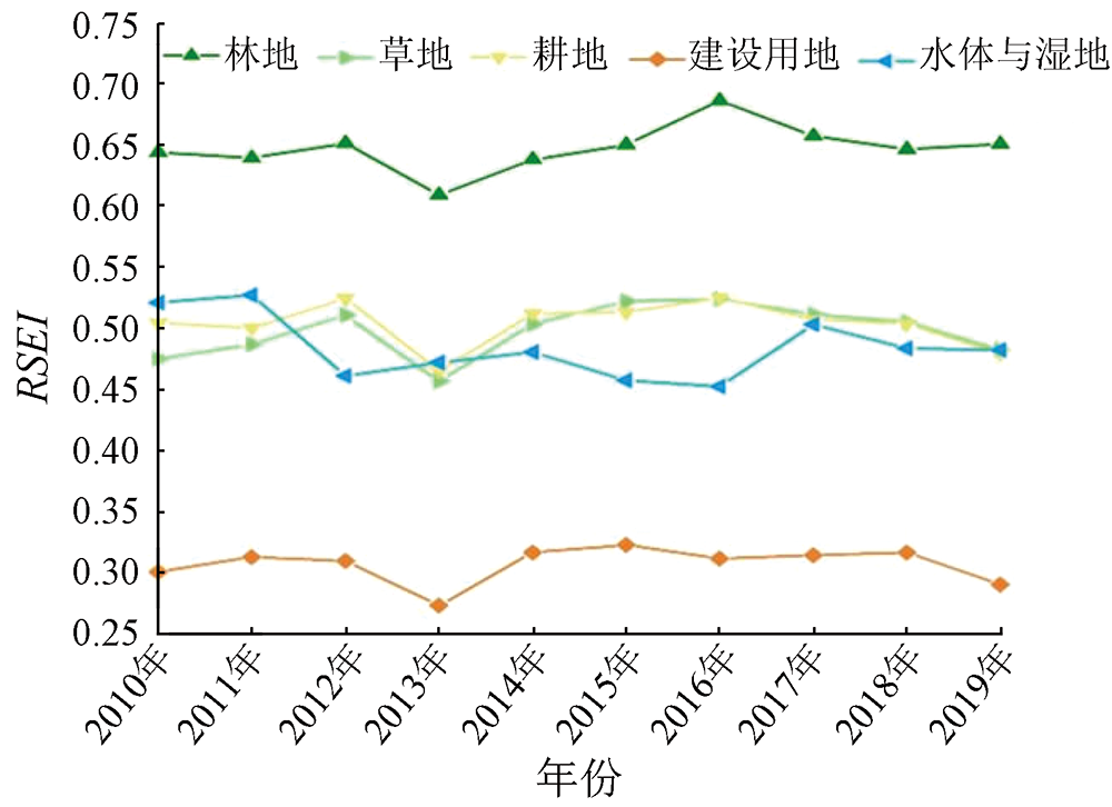
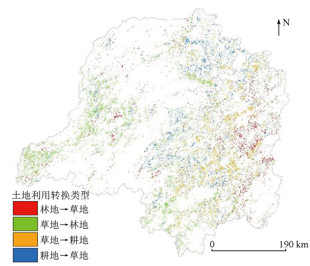
Abstract Since the Dongting Lake basin is a significant ecological zone in the middle and lower reaches of the Yangtze River, quantitative monitoring and evaluation of its ecological environment serve as a prerequisite for regional ecological conservation, restoration, and governance. Using MODIS products involving 2010—2019 remote sensing data, this study constructed the remote sensing ecological index (RSEI) for the Dongting Lake basin based on four ecological indices: greenness, humidity, dryness, and heat. Furthermore, this study explored the spatio-temporal dynamic characteristics of the ecological environment in the basin and their influencing factors. The results show that: ① From 2010 to 2019, the Dongting Lake basin exhibited an elevated greenness index, a reduced humidity index, and relatively stable dryness and heat indices; ② The ecological environment of the Dongting Lake basin was generally satisfactory, with a mean annual RSEI of 0.58, indicating a fluctuating growth. In terms of spatial distribution, the ecological environment in the western and surrounding areas was superior to that in the eastern and central areas; ③ There were strong correlations between RSEI and precipitation, air temperature, elevation, and land cover. The RSEI was the highest (0.65) for forest land and the lowest (0.31) for construction land. As for the two primary land conversion types (grassland → forest land, arable land → grassland) in the basin, the former type could improve the regional ecological environment (ΔRSEI=0.002 5, a contribution rate of 46.3%), whereas the latter type might lead to ecological environment deterioration (ΔRSEI=-0.000 4, contribution rate: 44.44%). The results of this study, assisting in deeply understanding the spatio-temporal characteristics of the ecological environment in the basin and their internal driving mechanisms and facilitating scientific land planning and ecological environment governance, hold critical theoretical and practical significance.
|
| Keywords
remote sensing ecological index
MODIS data
land use/cover change
Dongting Lake basin
|
|
|
|
Issue Date: 13 March 2024
|
|
|
| [1] |
彭燕, 何国金, 张兆明, 等. 赣南稀土矿开发区生态环境遥感动态监测与评估[J]. 生态学报, 2016, 36(6):1676-1685.
|
| [1] |
Peng Y, He G J, Zhang Z M, et al. Eco-environmental dynamic monitoring and assessment of rare earth mining area in Southern Ganzhou Using Remote Sensing[J]. Acta Ecologica Sinica, 2016, 36(6):1676-1685.
|
| [2] |
李爱军, 朱翔, 赵碧云, 等. 生态环境动态监测与评价指标体系探讨[J]. 中国环境监测, 2004, 20(4):35-38.
|
| [2] |
Li A J, Zhu X, Zhao B Y, et al. Preliminary study on construction of indicator system of dynamic monitoring and assessment of eco-environments[J]. Environmental Monitoring in China, 2004, 20(4):35-38.
|
| [3] |
Miao C L, Sun L Y, Yang L. The studies of ecological environmental quality assessment in Anhui Province based on ecological footprint[J]. Ecological Indicators, 2016, 60:879-883.
doi: 10.1016/j.ecolind.2015.08.040
url: https://linkinghub.elsevier.com/retrieve/pii/S1470160X15004720
|
| [4] |
邵波, 陈兴鹏. 甘肃省生态环境质量综合评价的AHP分析[J]. 干旱区资源与环境, 2005, 19(4):29-32.
|
| [4] |
Shao B, Chen X P. AHP analysis on the integrated assessment for the eco-environment of Gansu Province[J]. Journal of Arid Land Resources and Environment, 2005, 19(4):29-32.
|
| [5] |
叶亚平, 刘鲁君. 中国省域生态环境质量评价指标体系研究[J]. 环境科学研究, 2000, 13(3):33-36.
|
| [5] |
Ye Y P, Liu L J. A preliminary study on assessment indicator system of provincial eco-environmental quality in China[J]. Research of Environmental Sciences, 2000, 13(3):33-36.
|
| [6] |
厉彦玲, 朱宝林, 王亮, 等. 基于综合指数法的生态环境质量综合评价系统的设计与应用[J]. 测绘科学, 2005, 30(1):89-91,111.
|
| [6] |
Li Y L, Zhu B L, Wang L, et al. Designing and application of comprehensive index method based ecological environment quality comprehensive evaluation system[J]. Science of Surveying and Mapping, 2005, 30(1):89-91,111.
|
| [7] |
余晓芳. 基于遥感生态指数的喀斯特地区生态环境质量变化研究——以贵阳市为例[D]. 贵阳: 贵州师范大学, 2018:1-2.
|
| [7] |
Yu X F. The research of environment quality change of Karst area based on remote sensing based ecological index[D]. Guiyang: Guizhou Normal University, 2018:1-2.
|
| [8] |
姚尧, 王世新, 周艺, 等. 生态环境状况指数模型在全国生态环境质量评价中的应用[J]. 遥感信息, 2012, 27(3):93-98.
|
| [8] |
Yao Y, Wang S X, Zhou Y, et al. The application of ecological environment index model on the national evaluation of ecological environment quality[J]. Remote Sensing Information, 2012, 27(3):93-98.
|
| [9] |
王振华, 马海州, 周笃珺, 等. RS和GIS支持下的自然生态环境评价——以南水北调雅砻江工程区为例[J]. 盐湖研究, 2007, 15(1):1-4.
|
| [9] |
Wang Z H, Ma H Z, Zhou D J, et al. Integrated evaluation of eco-environment based on RS/GIS:A case study of the south-to-north water transfer project in Yalongjiang River[J]. Journal of Salt Lake Research, 2007, 15(1):1-4.
|
| [10] |
徐涵秋. 区域生态环境变化的遥感评价指数[J]. 中国环境科学, 2013, 33(5):889-897.
|
| [10] |
Xu H Q. A remote sensing index for assessment of regional ecological changes[J]. China Environmental Science, 2013, 33(5):889-897.
|
| [11] |
孙彩霞, 杨帆, 胡晋. 基于遥感数据的新生态环境指数评价[J]. 测绘通报, 2021,(11):12-15,53.
doi: 10.13474/j.cnki.11-2246.2021.330
|
| [11] |
Sun C X, Yang F, Hu J. New ecological index evaluation based on remote sensing data[J]. Bulletin of Surveying and Mapping, 2021,(11):12-15,53.
doi: 10.13474/j.cnki.11-2246.2021.330
|
| [12] |
徐涵秋. 城市遥感生态指数的创建及其应用[J]. 生态学报, 2013, 33(24):7853-7862.
|
| [12] |
Xu H Q. A remote sensing urban ecological index and its application[J]. Acta Ecologica Sinica, 2013, 33(24):7853-7862.
|
| [13] |
岳辉, 刘英, 朱蓉. 基于遥感生态指数的神东矿区生态环境变化监测[J]. 水土保持通报, 2019, 39(2):101-107,114.
|
| [13] |
Yue H, Liu Y, Zhu R. Monitoring ecological environment change based on remote sensing ecological index in Shendong mining area[J]. Bulletin of Soil and Water Conservation, 2019, 39(2):101-107,114.
|
| [14] |
王婷, 章新平, 黎祖贤, 等. 近52年来洞庭湖流域气象干旱的时空分布特征[J]. 长江流域资源与环境, 2016, 25(3):514-522.
|
| [14] |
Wang T, Zhang X P, Li Z X, et al. Temporal and spatial distribution characteristics of meteorological drought for recent 52 years in Dongting Lake basin[J]. Resources and Environment in the Yangtze Basin, 2016, 25(3):514-522.
|
| [15] |
邓正华, 戴丽琦, 邓冰, 等. 洞庭湖流域水资源承载力时空演变分析[J]. 经济地理, 2021, 41(5):186-192.
|
| [15] |
Deng Z H, Dai L Q, Deng B, et al. Spatial-temporal evolution of water resources carrying capacity in Dongting Lake basin[J]. Economic Geography, 2021, 41(5):186-192.
|
| [16] |
方精云, 郭兆迪, 朴世龙, 等. 1981—2000年中国陆地植被碳汇的估算[J]. 中国科学(D辑:地球科学), 2007, 37(6):804-812.
|
| [16] |
Fang J Y, Guo Z D, Piao S L, et al. Estimation of carbon sinks of tervestrial vegetation in China from 1981 to 2000[J]. Scientia in Sinica(Series D(Earth Sciences)), 2007, 37(6):804-812.
|
| [17] |
杨江燕, 吴田, 潘肖燕, 等. 基于遥感生态指数的雄安新区生态质量评估[J]. 应用生态学报, 2019, 30(1):277-284.
|
| [17] |
Yang J Y, Wu T, Pan X Y, et al. Ecological quality assessment of Xiongan New Area based on remote sensing ecological index[J]. Chinese Journal of Applied Ecology, 2019, 30(1):277-284.
|
| [18] |
陈超, 江涛, 刘祥磊. 基于缨帽变换的遥感图像融合方法研究[J]. 测绘科学, 2009, 34(3):105-106,163.
|
| [18] |
Chen C, Jiang T, Liu X L. Research on remote sensing image fusion methods based on tasseled cap transformation[J]. Science of Surveying and Mapping, 2009, 34(3):105-106,163.
|
| [19] |
Zhang X, Schaaf C B, Friedl M A, et al. MODIS tasseled cap transformation and its utility[C]// IEEE International Geoscience and Remote Sensing Symposium Toronto,Ontario,Canada.IEEE, 2002:1063-1065.
|
| [20] |
左璐, 孙雷刚, 鲁军景, 等. 基于MODIS的京津冀地区生态质量综合评价及其时空变化监测[J]. 自然资源遥感, 2022, 34(2):203-214.doi:10.6046/zrzyyg.2021224.
|
| [20] |
Zuo L, Sun G L, Lu J J, et al. MODIS-based comprehensive assessment and spatial-temporal change monitoring of ecological quality in Beijing-Tianjin-Hebei region[J]. Remote Sensing for Natural Resources, 2022, 34(2):203-214.doi:10.6046/zrzyyg.2021224.
|
| [21] |
王建, 赵牡丹, 李健波, 等. 基于MODIS时序数据的秦巴山区生态环境质量动态监测及驱动力分析[J]. 山地学报, 2021, 39(6):830-841.
|
| [21] |
Wang J, Zhao M D, Li J B, et al. Dynamic monitoring and driving forces of eco-environmental quality in the Qinba Mountains based on MODIS time-series data[J]. Mountain Research, 2021, 39(6):830-841.
|
| [22] |
尹建平. 基于遥感生态指数的平朔露天矿生态环境评价[J]. 露天采矿技术, 2021, 36(1):45-47.
|
| [22] |
Yin J P. Ecological environment evaluation based on remote sensing ecological index in Pingshuo Open-pit Mine[J]. Opencast Mining Technology, 2021, 36(1):45-47.
|
| [23] |
Feng H H, Liu Y B. Trajectory based detection of forest-change impacts on surface soil moisture at a basin scale Poyang Lake Basin,China[J]. Journal of Hydrology, 2014, 514:337-346.
doi: 10.1016/j.jhydrol.2014.04.044
url: https://linkinghub.elsevier.com/retrieve/pii/S0022169414003187
|
| [24] |
Feng H H, Zou B. A greening world enhances the surface-air temperature difference[J]. Science of the Total Environment, 2019, 658:385-394.
doi: 10.1016/j.scitotenv.2018.12.210
|
| [25] |
符静, 秦建新, 张猛, 等. 2001-2013年洞庭湖流域植被覆盖度时空变化特征[J]. 地球信息科学学报, 2016, 18(9):1209-1216.
doi: 10.3724/SP.J.1047.2016.01209
|
| [25] |
Fu J, Qin J X, Zhang M, et al. Spatial-temporal variations of vegetation coverage in the Lake Dongting Basin from 2001 to 2013[J]. Journal of Geo-Information Science, 2016, 18(9):1209-1216.
|
| [26] |
桑国庆, 唐志光, 邓刚, 等. 基于MODIS NDVI时序数据的湖南省植被变化研究[J]. 长江流域资源与环境, 2021, 30(5):1100-1109.
|
| [26] |
Sang G Q, Tang Z G, Deng G, et al. Study on vegetation change in Hunan Province based on MODIS NDVI time series data[J]. Resources and Environment in the Yangtze Basin, 2021, 30(5):1100-1109.
|
| [27] |
缪鑫辉, 梁勤欧. 基于遥感生态指数的甬江流域生态环境变化分析[J]. 长江流域资源与环境, 2021, 30(2):427-438.
|
| [27] |
Miao X H, Liang Q O. Analysis of ecological environment changes in Yongjiang River basin based on remote sensing ecological index[J]. Resources and Environment in the Yangtze Basin, 2021, 30(2):427-438.
|
| [28] |
宋慧敏, 薛亮. 基于遥感生态指数模型的渭南市生态环境质量动态监测与分析[J]. 应用生态学报, 2016, 27(12):3913-3919.
doi: 10.13287/j.1001-9332.201612.024
|
| [28] |
Song H M, Xue L. Dynamic monitoring and analysis of ecological environment in Weinan City,Northwest China based on RSEI model[J]. Chinese Journal of Applied Ecology, 2016, 27(12):3913-3919.
|
| [29] |
雷倩, 章新平, 黎祖贤, 等. 洞庭湖流域生长季气象特旱对植被覆盖的影响[J]. 长江流域资源与环境, 2020, 29(1):187-199.
|
| [29] |
Lei Q, Zhang X P, Li Z X, et al. Impacts of meteorological extreme drought during growing season on vegetation cover in Dongting Lake basin[J]. Resources and Environment in the Yangtze Basin, 2020, 29(1):187-199.
|
| [30] |
杨伶, 邓敏, 王金龙, 等. 近40年来洞庭湖流域土地利用及生态风险时空演变分析[J]. 生态学报, 2021, 41(10):3929-3939.
|
| [30] |
Yang L, Deng M, Wang J L, et al. Spatial-temporal evolution of land use and ecological risk in Dongting Lake Basin during 1980—2018[J]. Acta Ecologica Sinica, 2021, 41(10):3929-3939.
|
| [31] |
孔令桥, 郑华, 欧阳志云. 基于生态系统服务视角的山水林田湖草生态保护与修复——以洞庭湖流域为例[J]. 生态学报, 2019, 39(23):8903-8910.
|
| [31] |
Kong L Q, Zheng H, Ouyang Z Y. Ecological protection and restoration of forest,wetland,grassland and cropland based on the perspective of ecosystem services:A case study in Dongting Lake Watershed[J]. Acta Ecologica Sinica, 2019, 39(23):8903-8910.
|
| [32] |
刘英, 党超亚, 岳辉, 等. 改进型遥感生态指数与RSEI的对比分析[J]. 遥感学报, 2022, 26(4):683-697.
|
| [32] |
Liu Y, Dang C Y, Yue H, et al. Comparison between modified remote sensing ecological index and RSEI[J]. National Remote Sensing Bulletin, 2022, 26(4):683-697.
doi: 10.11834/jrs.20229338
url: http://www.ygxb.ac.cn/zh/article/doi/10.11834/jrs.20229338/
|
| [33] |
孙颖, 易浪, 尹少华. 洞庭湖流域植被覆盖变化及其协同治理[J]. 经济地理, 2022, 42(4):190-201.
doi: 10.15957/j.cnki.jjdl.2022.04.021
|
| [33] |
Sun Y, Yi L, Yin S H. Vegetation cover change in Dongting Lake basin and its coordination governance[J]. Economic Geography, 2022, 42(4):190-201.
doi: 10.15957/j.cnki.jjdl.2022.04.021
|
| [34] |
韩宇, 毛逸飞, 杨伶, 等. 洞庭湖流域生境质量对LUCC的动态响应[J]. 中南林业科技大学学报, 2023, 43(6):148-157.
|
| [34] |
Han Y, Mao Y F, Yang L, et al. Dynamic responses of habitat quality to LUCC in the Dongting Lake Basin[J]. Central South University of Forestry and Technology, 2023, 43(6):148-157.
|
|
Viewed |
|
|
|
Full text
|
|
|
|
|
Abstract
|
|
|
|
|
Cited |
|
|
|
|
| |
Shared |
|
|
|
|
| |
Discussed |
|
|
|
|
 2024,
Vol. 36
2024,
Vol. 36
 ), FENG Huihui(