|
|
|
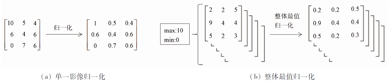
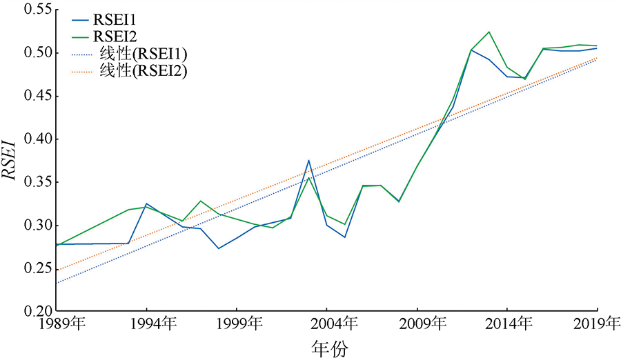
Abstract Ecological evaluation plays an important role in supporting urban development planning and using a remote sensing index to carry out ecological evaluation is a feasible method. Today, with the development of cloud computing, this paper explores a time-series calculation method of remote sensing ecological index suitable for Google Earth Engine, to address the problem that the calculation results of different sensors differ greatly in the process of big data calculation. Firstly, by taking Kuitun City, Xinjiang Uygur Autonomous Region, as the study area, this paper performs the de-clouded fusion process on Landsat images from 1989 to 2019. Secondly, this paper calculates the four major components of the fused images and makes preferences in the calculation of the humidity component and temperature component. Finally, this paper proposes the normalization method of the overall optimum and calculates the remotely sensed ecological index for each year on this basis. The analysis of the obtained results shows that the first principal component under the calculation by this method has a higher contribution rate, and the time series results on this basis have a higher polynomial fitting effect. It indicates that the method can specify uniform standards for different sensors, enhance the comparability of calculated results between different sensors, optimize the calculated results of remote sensing ecological indices, and ensure the interpretability of ecological evaluation grading results.
|
| Keywords
remote sensing ecological index
time series
Google Earth Engine
Kuitun City
ecological evaluation
|
|
|
|
Corresponding Authors:
MING Dongping
E-mail: 2004200020@cugb.edu.cn;mingdp@cugb.edu.cn
|
|
Issue Date: 20 June 2022
|
|
|
| [1] |
徐涵秋. 城市遥感生态指数的创建及其应用[J]. 生态学报, 2013, 33(24):7853-7862.
|
| [1] |
Xu H Q. A remote sensing urban ecological index and its application[J]. Acta Ecologica Sinica, 2013, 33(24):7853-7862.
|
| [2] |
贾浩巍, 颜长珍, 邢学刚, 等. 基于改进的遥感生态指数(MRSEI)的青海省都兰县生态环境质量评价[J]. 中国沙漠, 2021, 41(2):181-190.
|
| [2] |
Jia H W, Yan C Z, Xing X G, et al. Evaluation of ecological environment in the Dulan County based on the modified remote -sensing ecological index model[J]. Journal of Desert Research, 2021, 41(2):181-190.
|
| [3] |
李红星, 黄解军, 梁友嘉, 等. 基于遥感生态指数的武汉市生态环境质量评估[J]. 云南大学学报(自然科学版), 2020, 42(1):81-90.
|
| [3] |
Li H X, Huang J J, Liang Y J, et al. Evaluating the quality of ecological environment in Wuhan based on remote sensing ecological index[J]. Journal of Yunnan University(Natural Sciences Edition), 2020, 42(1):81-90.
|
| [4] |
缪鑫辉, 梁勤欧. 基于遥感生态指数的甬江流域生态环境变化分析[J]. 长江流域资源与环境, 2021, 30(2):427-438.
|
| [4] |
Miao X H, Liang Q O. Analysis of ecological environment changes in Yongjiang River basin based on remote sensing ecological index[J]. Resources and Environment in the Yangtze Basin, 2021, 30(2):427-438.
|
| [5] |
孙从建, 张文强, 李新功, 等. 基于遥感影像的黄土高原沟壑区生态效应评价[J]. 农业工程学报, 2019, 35(12):165-172.
|
| [5] |
Sun C J, Zhang W Q, Li X G, et al. Evaluation of ecological effect of gully region of loess plateau based on remote sensing image[J]. Transaction of the China Society of Agricultural Engineering, 2019, 35(12):165-172.
|
| [6] |
Noel G, Matt H, Mike D, et al. Google Earth Engine:Planetary-scale geospatial analysis for everyone[J]. Remote Sensing of Environment, 2017, 202:18-27.
doi: 10.1016/j.rse.2017.06.031
url: https://linkinghub.elsevier.com/retrieve/pii/S0034425717302900
|
| [7] |
陈炜, 黄慧萍, 田亦陈, 等. 基于Google Earth Engine平台的三江源地区生态质量动态监测与分析[J]. 地球信息科学学报, 2019, 21(9):1382-1391.
doi: 10.12082/dqxxkx.2019.190095
|
| [7] |
Chen W, Huang H P, Tian Y C, et al. Monitoring and assessment of the eco-environment quality in the Sanjiangyuan region based on Google Earth Engine[J]. Journal of Geo-Information Science, 2019, 21(9):1382-1391.
|
| [8] |
王渊, 赵宇豪, 吴健生. 基于Google Earth Engine云计算的城市群生态质量长时序动态监测——以粤港澳大湾区为例[J]. 生态学报, 2020, 40(23):8461-8473.
|
| [8] |
Wang Y, Zhao Y H, Wu J S. Dynamic monitoring of long time series of ecological quality in urban agglomerations using Google Earth Engine cloud computing:A case study of the Guangdong-Hong Kong-Macao Greater Bay Area,China[J]. Acta Ecologica Sinica, 2020, 40(23):8461-8473.
|
| [9] |
Xiong Y, Xu W H, Lu N, et al. Assessment of spatial-temporal changes of ecological environment quality based on RSEI and GEE:A case study in Erhai Lake basin,Yunnan Province,China[J]. Ecological Indicators, 2021, 125(125):107518.
doi: 10.1016/j.ecolind.2021.107518
url: https://linkinghub.elsevier.com/retrieve/pii/S1470160X21001837
|
| [10] |
赵英时. 遥感应用分析原理与方法[M]. 北京: 科学出版社, 2003:368-369.
|
| [10] |
Zhao Y S. Principles and methods of remote sensing application analysis[M]. Beijing: Science Press, 2003:368-369.
|
| [11] |
Crist E P, Cicone R C. A physically-based transformation of thematic mapper data-the TM tasseled cap[J]. IEEE Transactions on Geoscience and Remote Sensing, 1984, 22(3):256-263.
|
| [12] |
Crist E P. A TM tasseled cap equivalent transformation for reflectance factor data[J]. Remote Sensing of Environment, 1985, 17(3):301-306.
doi: 10.1016/0034-4257(85)90102-6
url: https://linkinghub.elsevier.com/retrieve/pii/0034425785901026
|
| [13] |
李博伦, 遆超普, 颜晓元. Landsat8陆地成像仪影像的缨帽变换推导[J]. 测绘科学, 2016, 41(4):102-107.
|
| [13] |
Li B L, Xi C P, Yan X Y. Study of derivation of tasseled cap transformation for Landsat8 OLI images[J]. Science of Surveying and Mapping, 2016, 41(4):102-107.
|
| [14] |
Baig M H A, Zhang L F, Shuai T, et al. Derivation of a tasselled cap transformation based on Landsat8 at-satellite reflectance[J]. Remote Sensing Letters, 2014, 5(5):423-431.
doi: 10.1080/2150704X.2014.915434
url: https://www.tandfonline.com/doi/full/10.1080/2150704X.2014.915434
|
| [15] |
Huang C, Wylie B, Yang L, et al. Derivation of a tasselled cap transformation based on Landsat7 at-satellite reflectance[J]. International Journal of Remote Sensing, 2002, 23(8):1741-1748.
doi: 10.1080/01431160110106113
url: https://www.tandfonline.com/doi/full/10.1080/01431160110106113
|
| [16] |
徐涵秋. 一种基于指数的新型遥感建筑用地指数及其生态环境意义[J]. 遥感技术与应用, 2007, 22(3):301-308.
|
| [16] |
Xu H Q. A new index-based built-up index(IBI) and its eco-environmental significance[J]. Remote Sensing Technology and Application, 2007, 22(3):301-308.
|
| [17] |
Xu H Q. A new index for delineating built-up land features in satellite imagery[J]. International Journal of Remote Sensing, 2008, 29(14):4269-4276.
doi: 10.1080/01431160802039957
url: https://www.tandfonline.com/doi/full/10.1080/01431160802039957
|
| [18] |
Rikimaru A, Roy P S, Miyatake S. Tropical forest cover density mapping[J]. Tropical Ecology, 2002, 43(1):39-47.
|
| [19] |
Jimenez-Munoz J C, Sobrino J A, Skokovic D, et al. Land surface temperature retrieval methods from Landsat8 thermal infrared sensor data[J]. IEEE Geoscience and Remote Sensing Letters, 2014, 11(10):1840-1843.
doi: 10.1109/LGRS.2014.2312032
url: http://ieeexplore.ieee.org/document/6784508/
|
| [20] |
Shlens J. A tutorial on principal component analysis[J]. Eprint Arxiv, 2014, 58(3):219-226.
|
| [21] |
Weng Q H, Lu D S, Schubring J. Estimation of land surface temperature-vegetation abundance relationship for urban heat island studies[J]. Remote Sensing of Environment, 2004, 89(4):467-483.
doi: 10.1016/j.rse.2003.11.005
url: https://linkinghub.elsevier.com/retrieve/pii/S0034425703003390
|
| [22] |
覃志豪, Zhang M H, Arnon K, 等. 用陆地卫星TM6数据演算地表温度的单窗算法[J]. 地理学报, 2001, 56(4):456-466.
doi: 10.11821/xb200104009
|
| [22] |
Qin Z H, Zhang M H, Arnon K, et al. Mono-window algorithm for retrieving land surface temperature from Landsat TM6 data[J]. Acta Geographica Sinica, 2001, 56(4):456-466.
doi: 10.11821/xb200104009
|
| [23] |
Nichol J. Remote sensing of urban heat islands by day and night[J]. Photogrammetric Engineering and Remote Sensing, 2005, 71(6):613-621.
doi: 10.14358/PERS.71.5.613
url: http://openurl.ingenta.com/content/xref?genre=article&issn=0099-1112&volume=71&issue=5&spage=613
|
| [24] |
Sobrino J A, Jimenez-Munoz J C, Soria G, et al. Land surface emissivity retrieval from different VNIR and TIR sensors[J]. IEEE Transactions on Geoscience and Remote Sensing, 2008, 46(2):316-327.
doi: 10.1109/TGRS.2007.904834
url: https://ieeexplore.ieee.org/document/4358831/
|
| [25] |
Yu X L, Guo X L, Wu Z C. Land surface temperature retrieval from Landsat8 TIRS:Comparison between radiative transfer equation-based method,split window algorithm and single channel method[J]. Remote Sensing, 2014, 6(10):9829-9852.
doi: 10.3390/rs6109829
url: http://www.mdpi.com/2072-4292/6/10/9829
|
|
Viewed |
|
|
|
Full text
|
|
|
|
|
Abstract
|
|
|
|
|
Cited |
|
|
|
|
| |
Shared |
|
|
|
|
| |
Discussed |
|
|
|
|
 2022,
Vol. 34
2022,
Vol. 34
 ), MING Dongping(