|
|
|
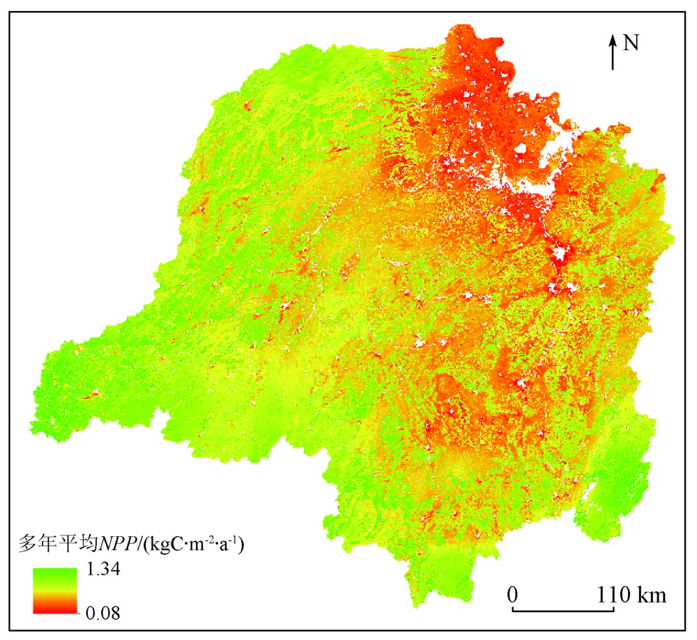
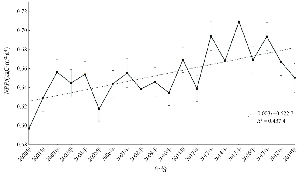
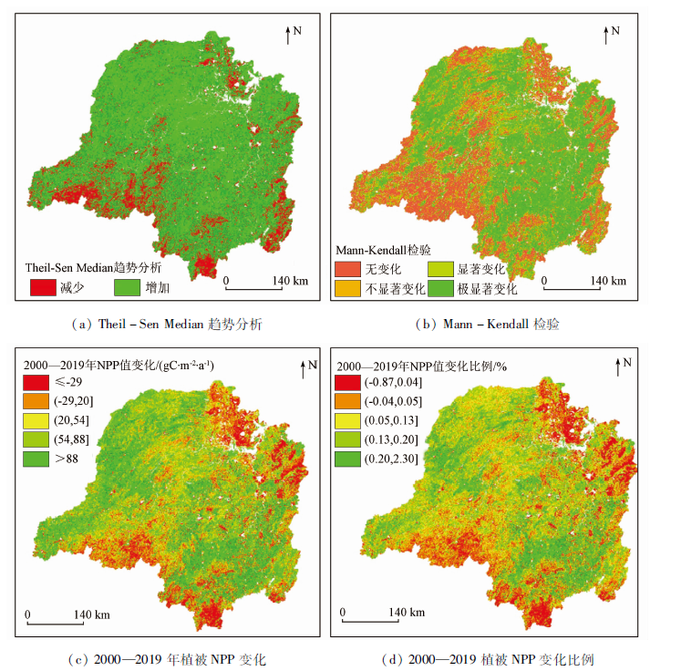
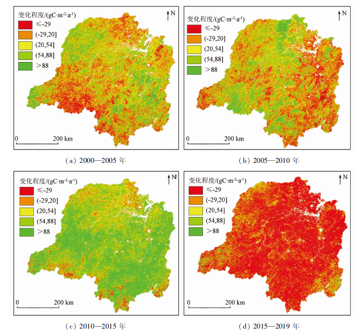
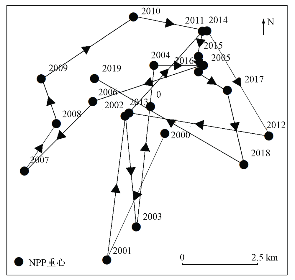
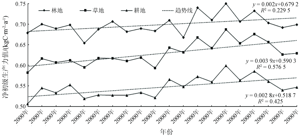
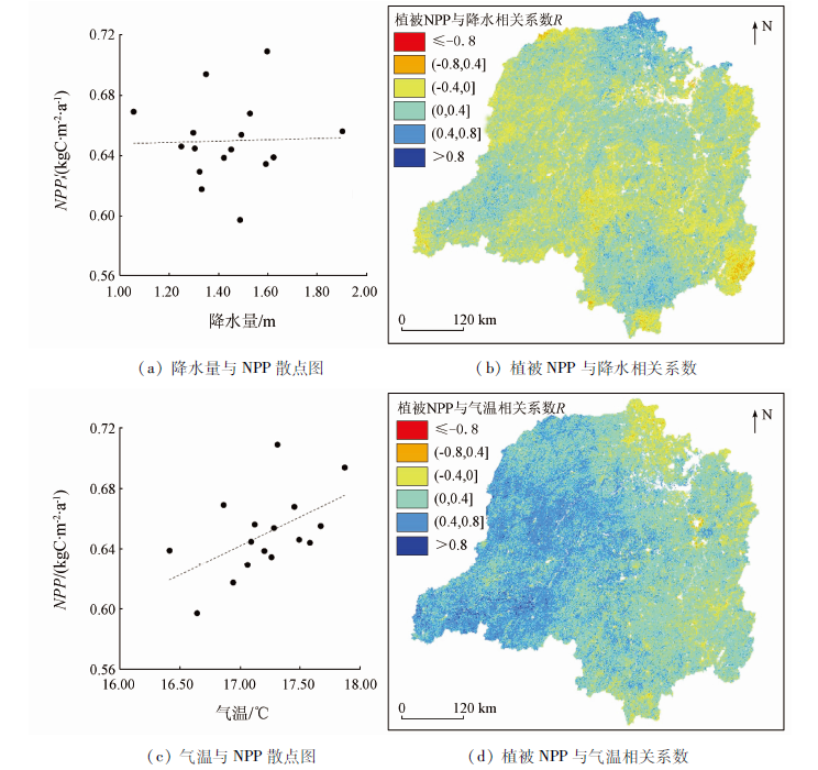
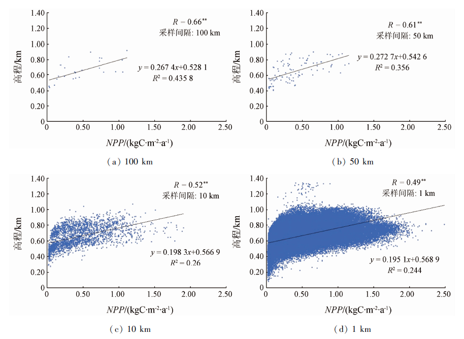
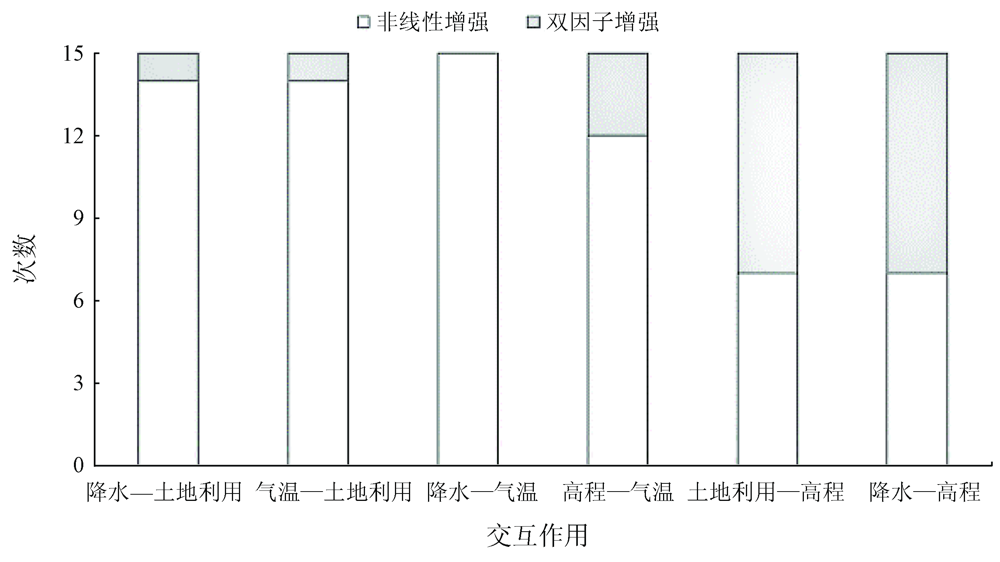
Abstract The net primary productivity (NPP) of vegetation is a vital indicator for assessing a basin ecosystem. Based on a long time series of NPP data of 2000—2019 from a moderate resolution imaging spectroradiometer (MODIS), this study analyzed the spatio-temporal variations in the vegetation NPP of the Dongting Lake basin in the past 20 years. Then, it revealed the influence characteristics and contribution of driving factors (e.g., meteorology and ground surface) on the vegetation NPP of the study area using methods including the GIS spatio-temporal analysis and GeoDetector. The results are as follows. ① The NPP values in the study area have an average of 0.65 kgC/(m2·a), with high values mainly distributed in the west and south of the basin and low values concentrated near the lake. ② During 2000—2019, the vegetation NPP of the Dongting Lake basin presented a slightly rising trend (y=0.003x+0.622 7, R2=0.437, p<0.001). It increased in the northwest and south-central parts and decreased in the northeast and southwest boundaries, and its center of gravity slightly shifted. ③ The changes in the vegetation NPP of the Dongting Lake basin was significantly affected by meteorological factors (especially temperature). By contrast, its spatial characteristics were mainly affected by land use, followed by precipitation and DEM. In addition, the results suggested significant interactions between different factors, which was mainly reflected by the bi-factor enhancement (DEM and land use, or DEM and precipitation) and nonlinear enhancement (temperature and precipitation, land use and DEM, and precipitation and land use). The conclusions of this study help to correctly understand and grasp the spatio-temporal characteristics of the vegetation NPP of the Dongting Lake basin and their internal influencing mechanisms, thus providing a scientific basis for the management and governance of the ecosystem in the basin.
|
| Keywords
Dongting Lake basin
vegetation NPP
spatio-temporal characteristics
driving factor
|
|
|
|
Corresponding Authors:
FENG Huihui
E-mail: 0107150123@csu.edu.cn;hhfeng@csu.edu.cn
|
|
Issue Date: 21 September 2022
|
|
|
| [1] |
梁顺林, 李小文, 王锦地. 定量遥感:理念与算法[M]. 北京: 科学出版社, 2013.
|
| [1] |
Liang S L, Li X W, Wang J D. Quantitative remote sensing:Concepts and algorithms[M]. Beijing: Science Publishing Company, 2013.
|
| [2] |
李登科, 王钊. 基于 MOD17A3 的中国陆地植被 NPP 变化特征分析[J]. 生态环境学报, 2018, 27(3):397-405.
|
| [2] |
Li D K, Wang Z. The characteristics of NPP of terrestrial vegetation in China based on MOD17A3 data[J]. Ecology and Environmental Sciences, 2018, 27(3):397-405.
|
| [3] |
王莺, 夏文韬, 梁天刚. 陆地生态系统净初级生产力的时空动态模拟研究进展[J]. 草业科学, 2010, 27(2):77-88.
|
| [3] |
Wang Y, Xia W T, Liang T G. Research progress on spatial-temporal dynamic simulation model of net primary productivity of terrestrial ecosystems[J]. Pratacultural Science, 2010, 27(2):77-88.
|
| [4] |
周珺. 基于遥感数据的重庆市净初级生产力(NPP)时空特征研究[D]. 重庆: 西南大学, 2013.
|
| [4] |
Zhou J. Spatial and temporal characteristics of net primary productivity (NPP) in Chongqing based on remote sensing data[D]. Chongqing: Southwest University, 2013.
|
| [5] |
朱文泉, 潘耀忠, 张锦水. 中国陆地植被净初级生产力遥感估算[J]. 植物生态学报, 2007, 31(3):413-424.
doi: 10.17521/cjpe.2007.0050
|
| [5] |
Zhu W Q, Pan Y Z, Zang J S. Remote sensing estimation of net primary productivity of terrestrial vegetation in China[J]. Journal of Plant Ecology, 2007, 31(3):413-424.
|
| [6] |
Pan S F, Tian H Q, Dangal S, et al. Modeling and monitoring terrestrial primary production in a changing global environment:Toward a multiscale synthesis of observation and simulation[J]. Advances in Meteorology, 2014, 6426:1-14.
|
| [7] |
焦伟, 陈亚宁, 李稚. 西北干旱区植被净初级生产力的遥感估算及时空差异原因[J]. 生态学杂志, 2017, 36(1):181-189.
|
| [7] |
Jiao W, Chen Y N, Li Z. Remote sensing estimation of net primary productivity of vegetation in arid area of Northwest China and its spatio-temporal differences[J]. Chinese Journal of Ecology, 2017, 36(1):181-189.
|
| [8] |
Robinson N P, Allred B W, Smith W K, et al. Terrestrial primary production for the conterminous United States derived from Landsat 30 m and MODIS 250 m[J]. Remote Sensing in Ecology and Conservation, 2018, 4(3):264-280.
doi: 10.1002/rse2.74
url: https://onlinelibrary.wiley.com/doi/10.1002/rse2.74
|
| [9] |
杨允菲, 祝廷成. 植物生态学(第2版)[M]. 北京: 高等教育出版社, 2011.
|
| [9] |
Yang Y F, Zhu T C. Plant ecology (2nd Ed.) [M]. Beijing: Higher Education Press, 2011.
|
| [10] |
Grosso S D, Parton W, Stohlgren T, et al. Global potential net primary production predicted from vegetation class precipitation and temperature[J]. Ecology, 2010, 89(8):2117-2126.
doi: 10.1890/07-0850.1
url: http://doi.wiley.com/10.1890/07-0850.1
|
| [11] |
刘凤, 曾永年. 近16年青海高原植被NPP时空格局变化及气候与人为因素的影响[J]. 生态学报, 2019, 39(5):1528-1540.
|
| [11] |
Liu F, Zeng Y N. Spatial-temporal change in vegetation net primary productivity and its response to climate and human activities in Qinghai Plateau in the past 16 years[J]. Acta Ecologica Sinica, 2019, 39(5):1528-1540.
|
| [12] |
徐雨晴, 肖风劲, 於琍. 中国森林生态系统净初级生产力时空分布及其对气候变化的响应研究综述[J]. 生态学报, 2020, 40(14):4710-4723.
|
| [12] |
Xu Y Q, Xiao F J, Yu L. Forest ecosystem net primary productivity and its response to climate change in China:A review[J]. Acta Ecologica Sinica, 2020, 40(14):4710-4723.
|
| [13] |
刘旻霞, 焦骄, 潘竟虎, 等. 青海省植被净初级生产力(NPP)时空格局变化及其驱动因素[J]. 生态学报, 2020, 40(15):5306-5317.
|
| [13] |
Liu M X, Jiao J, Pan J H, et al. Spatial and temporal patterns of planting NPP and its driving factors in Qinghai Province[J]. Acta Ecologica Sinica, 2020, 40(15):5306-5317.
|
| [14] |
潘瑞炽, 董愚得. 植物生理学[M]. 北京: 高等教育出版社, 1979.
|
| [14] |
Pan R C, Dong Y D. Plant physiology[M]. Beijing: Higher Education Press, 1979.
|
| [15] |
张其德. 温度对植物光合作用的影响[J]. 植物杂志, 1989(3):28-30.
|
| [15] |
Zhang Q D. Effects of temperature on photosynthesis in plants[J]. The Plant Journal, 1989(3):28-30.
|
| [16] |
张雪萍. 生态学原理[M]. 北京: 科学出版社, 2011.
|
| [16] |
Zhang X P. Principles of ecology[M]. Beijing: Science Publishing Company, 2011.
|
| [17] |
黄怀勇, 杜国铨, 范蔚茗, 等. 全流域蓄水与洞庭湖蓄洪能力[J]. 世界科技研究与发展, 2020(s1):42-44.
|
| [17] |
Huang H Y, Du G Q, Fan W M, et al. Water storage and flood storage capacity of Dongting Lake[J]. World Science and Technology Research and Development, 2020(s1):42-44.
|
| [18] |
刘恒, 汤弟伟, 宋鄂平, 等. 2000—2015年武陵山区植被净初级生产力的时空动态特征及其驱动因子[J]. 水土保持研究, 2020, 143(6):224-231.
|
| [18] |
Liu H, Tang D W, Song E P, et al. Temporal and spatial dynamics of vegetation net primary productivity and its driving factors in Wuling Mountain area from 2000 to 2015[J]. Research of Soil and Water Conservation, 2020, 143(6):224-231.
|
| [19] |
陈舒婷, 郭兵, 杨飞, 等. 2000—2015年青藏高原植被时空变化格局及其对气候变化的响应[J]. 自然资源学报, 2020, 35(10):2511-2527.
|
| [19] |
Chen S T, Guo B, Yang F, et al. Temporal and spatial patterns of vegetation and its response to climate change in the Tibetan Plateau during 2000—2015[J]. Journal of Natural Resources, 2020, 35(10):2511-2527.
doi: 10.31497/zrzyxb.20201016
url: http://www.jnr.ac.cn/EN/10.31497/zrzyxb.20201016
|
| [20] |
王劲峰, 徐成东. 地理探测器:原理与展望[J]. 地理学报, 2017, 72(1):116-134.
doi: 10.11821/dlxb201701010
|
| [20] |
Wang J F, Xu C D. Geodetectors:Principles and prospects[J]. Journal of Geographical Sciences, 2017, 72(1):116-134.
|
| [21] |
孟凡超, 郭军, 周莉, 等. 气温,浓度和降水交互作用对作物生长和产量的影响[J]. 应用生态学报, 2017, 28(12):4117-4126.
doi: 10.13287/j.1001-9332.201712.023
|
| [21] |
Meng F C, Guo J, Zhou L, et al. Effects of precipitation and concentration on crop growth and yield[J]. Chinese Journal of Applied Ecology, 2017, 28(12):4117-4126.
|
| [22] |
Feng H H, Liu Y B, et al. Combined effects of precipitation and air temperature on soil moisture in different land covers in a humid basin[J]. Journal of Hydrology, 2015, 531:1129-1140.
doi: 10.1016/j.jhydrol.2015.11.016
url: https://linkinghub.elsevier.com/retrieve/pii/S0022169415008926
|
| [23] |
Feng H H, Zou B. A greening world enhances the surface-air temperature difference[J]. Science of the Total Environment, 2019, 658:385-394.
doi: 10.1016/j.scitotenv.2018.12.210
url: https://linkinghub.elsevier.com/retrieve/pii/S0048969718350733
|
| [24] |
Feng H H, Zou B, Luo J. Coverage-dependent amplifiers of vegetation change on global water cycle dynamics[J]. Journal of Hydrology, 2017, 550:220-229.
doi: 10.1016/j.jhydrol.2017.04.056
url: https://linkinghub.elsevier.com/retrieve/pii/S0022169417302779
|
| [25] |
孙杰, 范士杰, 臧建飞, 等. 3种全球气压与温度模型的精度对比分析[J]. 测绘科学, 2018, 43(9):63-67,75.
|
| [25] |
Sun J, Fan S J, Zang J F, et al. Comparative analysis of accuracy of three global pressure and temperature models[J]. Science of Surveying and Mapping, 2018, 43(9):63-67,75.
|
| [26] |
邓院昌, 刘沙, 余志, 等. 实际地形风场CFD模拟中粗糙度的影响分析[J]. 太阳能学报, 2010(12):1644-1648.
|
| [26] |
Deng Y C, Liu S, Yu Z, et al. Effect analysis of roughness in CFD simulation of real terrain wind field[J]. Acta Energiae Solaris Sinica, 2010(12):1644-1648.
|
|
Viewed |
|
|
|
Full text
|
|
|
|
|
Abstract
|
|
|
|
|
Cited |
|
|
|
|
| |
Shared |
|
|
|
|
| |
Discussed |
|
|
|
|
 2022,
Vol. 34
2022,
Vol. 34
 ), FENG Huihui(