|
|
 |
|

|
|
|
Extraction and spatio-temporal change analysis of the tidal flat in Cixi section of Hangzhou Bay based on Google Earth Engine |
ZHENG Xiucheng1,2,3( ), ZHOU Bin1,2,3(), LEI Hui1,2,3, HUANG Qiyu3, YE Haolin3 ), ZHOU Bin1,2,3(), LEI Hui1,2,3, HUANG Qiyu3, YE Haolin3 |
1. Institute of Remote Sensing and Earth Science, Hangzhou Normal University, Hangzhou 311121, China
2. Zhejiang Provincial Key Laboratory of Urban Wetlands and Regional Change, Hangzhou 311121, China
3. School of Information Science and Technology, Hangzhou Normal University, Hangzhou 311121, China |
|
|
|
|
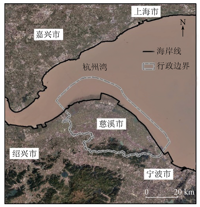
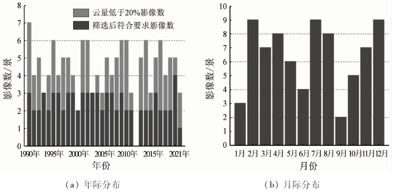
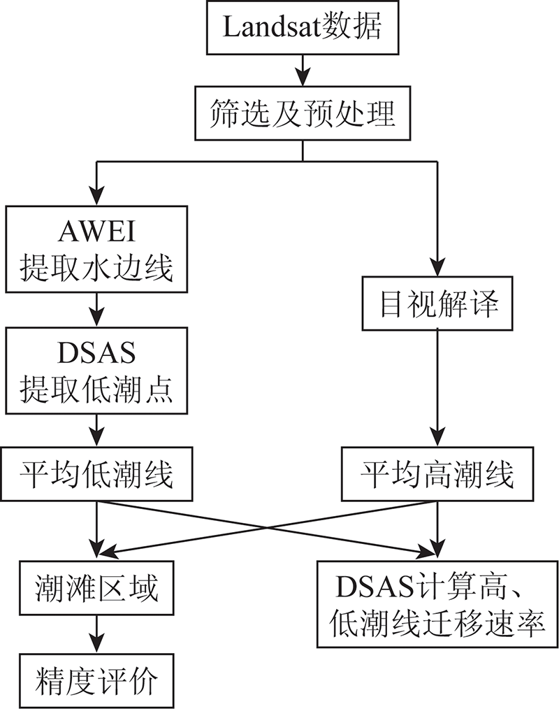
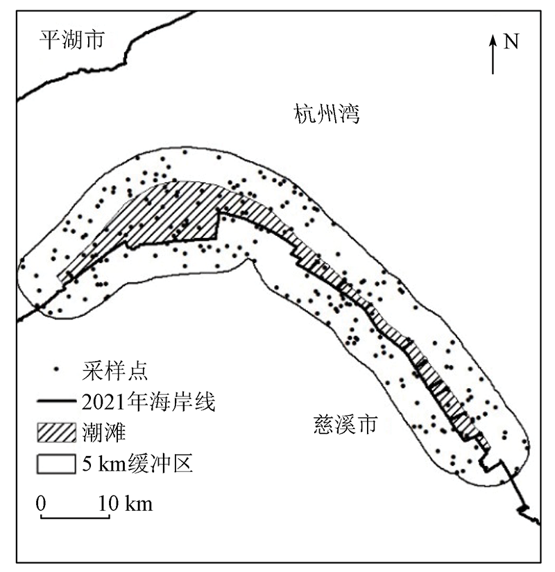
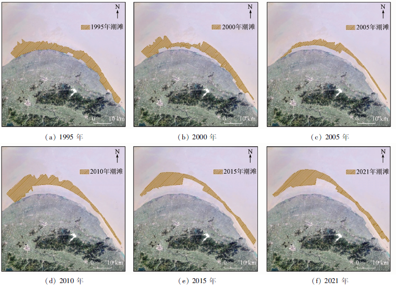
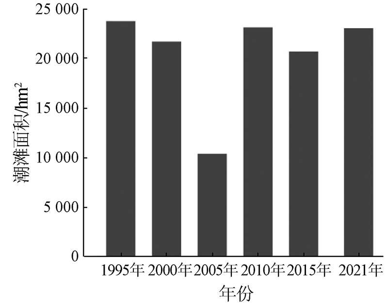
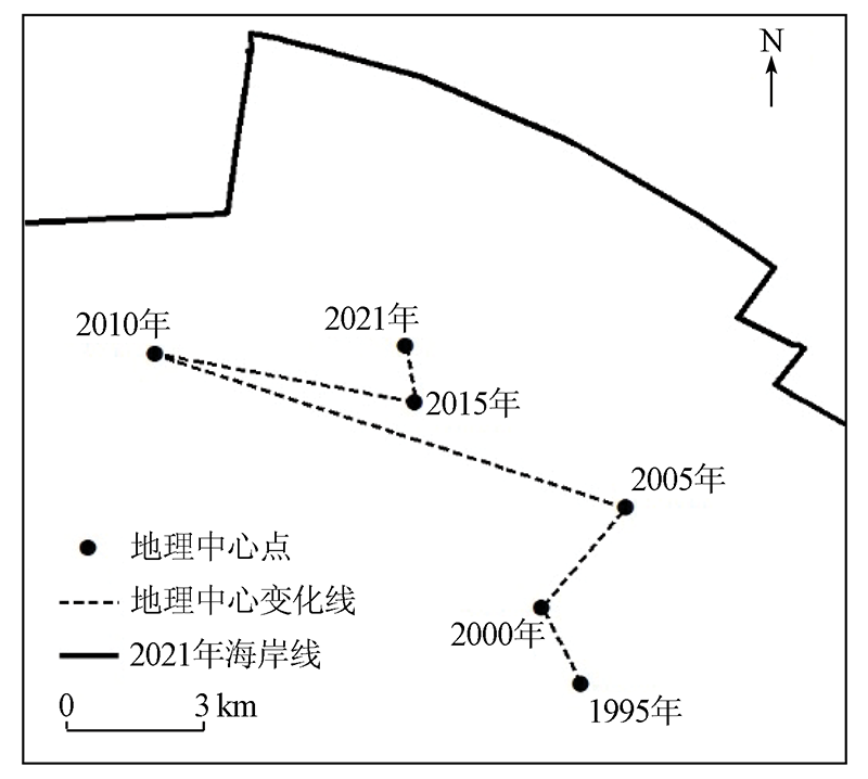
Abstract At present, the common methods for extracting tidal flats using remote sensing images tend to estimate tidal flat boundaries. Therefore, it is difficult to ensure high extraction accuracy. This study combined remote sensing cloud computing platform Google Earth Engine with the geographic information system (GIS) technology and selected 77 Landsat images during 1990—2021. Meanwhile, the mean high-tide line was set to the artificial coastline obtained through visual interpretation, and the mean low-tide line was determined through the fitting of the shoreline. Based on these, this study extracted the tidal flat in the Cixi section on the south bank of the Hangzhou Bay and estimated its area. Furthermore, this study analyzed the spatio-temporal changes in the area of the tidal flat. The results are as follows. During 1990—2021, the area of the tidal flat in the Cixi section on the south bank of the Hangzhou Bay was roughly maintained in the range of 20 000~24 000 hm2, and the tidal flat migrated from south to north at a speed of 286.9 m·a-1. The main driving force behind the spatial and area changes of the tidal flat was local policies.
|
| Keywords
tidal flat
Google Earth Engine
DSAS
shoreline
Hangzhou Bay
|
|
|
|
Corresponding Authors:
ZHOU Bin
E-mail: 2017210214034@stu.hznu.edu.cn;zhoubin@hznu.edu.cn
|
|
Issue Date: 14 March 2022
|
|
|
| [1] |
王颖, 朱大奎. 中国的潮滩[J]. 第四纪研究, 1990(4):291-300.
|
| [1] |
Wang Y, Zhu D K. Tidal flats of China[J]. Quaternary Sciences, 1990(4):291-300.
|
| [2] |
时钟, 陈吉余, 虞志英. 中国淤泥质潮滩沉积研究的进展[J]. 地球科学进展, 1996(6):37-44.
|
| [2] |
Shi Z, Chen J Y, Yu Z Y. Sedimentation on the intertidal mudflat in China:An overview[J]. Advances in Earth Science, 1996(6):37-44.
|
| [3] |
张春桂. MODIS遥感数据在福建省海岸带滩涂资源监测中的应用研究[J]. 海洋学报, 2007(4):51-58.
|
| [3] |
Zhang C G. The application of MODIS data in tidal flat resource monitoring of coastal zone of Fujian Province in China[J]. Acta Oceonlolgica Sinica, 2007(4):51-58.
|
| [4] |
王小龙, 张杰, 初佳兰. 基于光学遥感的海岛潮间带和湿地信息提取——以东沙岛(礁)为例[J]. 海洋科学进展, 2005(4):477-481.
|
| [4] |
Wang X L, Zhang J, Chu J L. Extraction of remotely sensed information of island intertidal zone and wetland:Taking the Dongsha Island as an example[J]. Advances in Marine Science, 2005(4)477-481.
|
| [5] |
王小丹, 方成, 康慧, 等. 曹妃甸地区潮间带演变的遥感监测[J]. 海洋通报, 2014, 33(5):559-565.
|
| [5] |
Wang X D, Fang C, Kang H, et al. Remote sensing monitoring of the Caofeidian tidal zone evolution[J]. Marine Science Bulletin, 2014, 33(5):559-565.
|
| [6] |
王靖雯, 牛振国. 基于潮位校正的盐城滨海潮间带遥感监测及变化分析[J]. 海洋学报, 2017, 39(5):149-160.
|
| [6] |
Wang J W, Niu Z G. Remote-sensing analysis of Yancheng intertidal zones based on tidal correction[J]. Haiyang Xuebao, 2017, 39(5):149-160.
|
| [7] |
韩倩倩, 牛振国, 吴孟泉, 等. 基于潮位校正的中国潮间带遥感监测及变化[J]. 科学通报, 2019, 64(4):456-473.
|
| [7] |
Han Q Q, Niu Z G, Wu M Q, et al. Remote-sensing monitoring and analysis of China intertidal zone changes based on tidal correction[J]. Chinese Science Bulletin, 2019, 64(4):456-473.
|
| [8] |
张媛媛, 高志强, 刘向阳, 等. 基于遥感水边线的潮滩面积提取方法研究[J]. 海洋开发与管理, 2018, 35(3):56-61.
|
| [8] |
Zhang Y Y, Gao Z Q, Liu X Y, et al. The extraction method of tidal flat area based on remote sensing waterlines[J]. Ocean Development and Management, 2018, 35(3):56-61.
|
| [9] |
胡允和, 施德忠. 慈溪海涂促淤浅析[J]. 浙江水利科技, 1984(2):22-32.
|
| [9] |
Hu Y H, Shi D Z. Brief analysis of Cixi sea flat to promote sedimentation[J]. Zhejiang Hydrotechnics, 1984(2):22-32.
|
| [10] |
王丽佳, 李加林, 田鹏, 等. 杭州湾南岸围垦土地人类活动强度及对滨海湿地覆被类型的影响[J]. 上海国土资源, 2020, 41(1):4-10.
|
| [10] |
Wang L J, Li J L, Tian P, et al. Impacts of human activity on coastal wetland land cover changes related to reclamation on the south coast of Hangzhou Bay[J]. Shanghai Land and Resources, 2020, 41(1):4-10.
|
| [11] |
韩茜. 基于遥感技术的我国潮滩资源现状研究[D]. 南京: 南京师范大学, 2011.
|
| [11] |
Han Q. Research on the status of tidal resources in China using remote sensing technology[D]. Nanjing:Nanjing Normal University, 2011.
|
| [12] |
张振德, 肖继春. 遥感在滩涂演变调查中的应用方法研究[J]. 自然资源遥感, 1995, 7(3):25-28.doi: 10.6046/gtzyyg.1995.03.05.
doi: 10.6046/gtzyyg.1995.03.05
|
| [12] |
Zhang Z D, Xiao J C. The application of remote sensing to investigate tidal flat evolution[J]. Remote Sensing for Land and Resources, 1995, 7(3):25-28.doi: 10.6046/gtzyyg.1995.03.05.
doi: 10.6046/gtzyyg.1995.03.05
|
| [13] |
赵明才, 章大初. 海岸线定义问题的讨论[J]. 海岸工程, 1990(z1):91-99.
|
| [13] |
Zhao M C, Zhang D C. Discussions on the definition of shoreline[J]. Coastal Engineering, 1990(z1):91-99.
|
| [14] |
盛静芬, 朱大奎. 海岸侵蚀和海岸线管理的初步研究[J]. 海洋通报, 2002(4):50-57.
|
| [14] |
Sheng J F, Zhu D K. Discussion about coastline erosion and management[J]. Marine Science Bulletin, 2002(4):50-57.
|
| [15] |
吴一全, 刘忠林. 遥感影像的海岸线自动提取方法研究进展[J]. 遥感学报, 2019, 23(4):582-602.
|
| [15] |
Wu Y Q, Liu Z L. Research progress on methods of automatic coastline extraction based on remote sensing images[J]. Journal of Remote Sensing, 2019, 23(4):582-602.
|
| [16] |
杨修国. 图像阈值分割方法研究与分析[D]. 上海: 华东师范大学, 2009.
|
| [16] |
Yang X G. Threshold image segmentation research and analysis[D]. Shanghai:East China Normal University, 2009.
|
| [17] |
Feyisa G L, Henrik M, Rasmus F, et al. Automated water extraction index:A new technique for surface water mapping using Landsat imagery[J]. Remote Sensing of Environment, 2014, 140:23-35
doi: 10.1016/j.rse.2013.08.029
url: https://linkinghub.elsevier.com/retrieve/pii/S0034425713002873
|
| [18] |
Xu H Q. Modification of normalised difference water index (NDWI) to enhance open water features in remotely sensed imagery[J]. International Journal of Remote Sensing, 2006, 27(14):3025-3033
doi: 10.1080/01431160600589179
url: https://www.tandfonline.com/doi/full/10.1080/01431160600589179
|
| [19] |
饶萍, 王建力. 最优分区与最优指数联合的水体信息提取[J]. 地球信息科学学报, 2017, 19(5):702-712.
doi: 10.3724/SP.J.1047.2017.00702
|
| [19] |
Rao P, Wang J L. Water extraction based on the optimal subregion and the optimal indexes combined[J]. Journal of Geo-Information Science, 2017, 19(5):702-712.
|
| [20] |
陈星壮. 基于高分辨率遥感影像的城市水体提取算法研究[D]. 成都: 电子科技大学, 2021.
|
| [20] |
Chen X Z. Urban open water extraction from high resolution remote sensing images[D]. Chengdu:University of Electronic Science and Technology of China, 2021.
|
| [21] |
Otsu N. Threshold selection method from gray-level histograms[J]. IEEE Transactions on Systems Man and Cybernetics, 1979, 9(1):62-66.
doi: 10.1109/TSMC.1979.4310076
url: http://ieeexplore.ieee.org/document/4310076/
|
| [22] |
Thieler E, Himmelstoss E, Zichichi J, et al. The Digital Shoreline Analysis System (DSAS) Version 4.0:An ArcGIS extension for calculating shoreline change[R]. Reston:U.S. Geological Survey, 2009.
|
| [23] |
张华国, 郭艳霞, 黄韦艮, 等. 1986年以来杭州湾围垦淤涨状况卫星遥感调查[J]. 自然资源遥感, 2005, 17(2):50-54,81.doi: 10.6046/gtzyyg.2005.02.12.
doi: 10.6046/gtzyyg.2005.02.12
|
| [23] |
Zhang H G, Guo Y X, Huang W G, et al. A remote sensing investigating of inning and silting in Hangzhou Bay since 1986[J]. Remote Sensing for Land and Resources, 2005, 17(2):50-54,81.doi: 10.6046/gtzyyg.2005.02.12.
doi: 10.6046/gtzyyg.2005.02.12
|
| [24] |
Foody G M. Status of land cover classification accuracy assessment[J]. Remote Sensing of Environment, 2002, 80(1):185-201.
doi: 10.1016/S0034-4257(01)00295-4
url: https://linkinghub.elsevier.com/retrieve/pii/S0034425701002954
|
| [25] |
Congalton R G. A review of assessing the accuracy of classifications of remotely sensed data[J]. Remote Sensing of Environment, 1991, 37(1):35-46.
doi: 10.1016/0034-4257(91)90048-B
url: https://linkinghub.elsevier.com/retrieve/pii/003442579190048B
|
| [26] |
朱世强. 高水平建设慈溪杭州湾新区[J]. 今日浙江, 2003(19):33-34.
|
| [26] |
Zhu S Q. High-level construction of Hangzhou Bay New District in Cixi[J]. Zhejiang Today, 2003(19):33-34.
|
| [27] |
孙超, 刘永学, 李满春, 等. 近25 a来江苏中部沿海盐沼分布时空演变及围垦影响分析[J]. 自然资源学报, 2015, 30(9):1486-1498.
|
| [27] |
Sun C, Liu Y X, Li M C, et al. Spatiotemporal evolution of salt marsh and influential analysis of reclamation of Jiangsu middle coast in recent 25 years[J]. Journal of Natural Resources, 2015, 30(9):1486-1498.
|
| [28] |
国务院. 国务院关于加强滨海湿地保护严格管控围填海的通知[EB/OL]. http://www.gov.cn/zhengce/content/2018-07/25/content_5309058.htm.
url: http://www.gov.cn/zhengce/content/2018-07/25/content_5309058.htm.
|
| [28] |
The central people’s government of the PRC. Notice of the state council on strengthening the protection of coastal wetlands and strictly controlling reclamation[EB/OL].http://www.gov.cn/zhengce/content/2018-07/25/content_5309058.htm.
url: http://www.gov.cn/zhengce/content/2018-07/25/content_5309058.htm.
|
| [29] |
潘存鸿, 郑君, 曾剑, 等. 杭州湾年最大潮差分析[J]. 水动力学研究与进展(A辑), 2021, 36(2):201-209.
|
| [29] |
Pan C H, Zheng J, Zeng J, et al. Analysis of annual maximum tidal range in Hangzhou Bay[J]. Chinese Journal of Hydrodynamics, 2021, 36(2):201-209.
|
| [30] |
潘存鸿, 郑君, 陈刚, 等. 杭州湾潮汐特征时空变化及原因分析[J]. 海洋工程, 2019, 37(3):1-11.
|
| [30] |
Pan C H, Zheng J, Chen G, et al. Spatial and temporal variations of tide characteristics in Hangzhou Bay and cause analysis[J]. The Ocean Engineering, 2019, 37(3):1-11.
doi: 10.1016/j.oceaneng.2009.12.002
url: https://linkinghub.elsevier.com/retrieve/pii/S0029801809002741
|
|
Viewed |
|
|
|
Full text
|
|
|
|
|
Abstract
|
|
|
|
|
Cited |
|
|
|
|
| |
Shared |
|
|
|
|
| |
Discussed |
|
|
|
|
 2022,
Vol. 34
2022,
Vol. 34