Please wait a minute...
 
Remote Sensing for Natural Resources    2024, Vol. 36 Issue (2) : 21-26     DOI: 10.6046/zrzyyg.2022440
|
Distributions and existing problems of mining land of abandoned open-pit mines in China
XING Yu1(), WANG Jingya2, YANG Jinzhong1(), CHEN Dong1, DU Xiaomin1, GUO Jingkai1, SONG Licong2
1. China Aero Geophysical Survey and Remote Sensing Center for Natural Resources, Beijing 100083, China
2. School of Earth Sciences and Resources, China University of Geosciences (Beijing), Beijing 100083, China
Download: PDF(2255 KB)   HTML
Export: BibTeX | EndNote | Reference Manager | ProCite | RefWorks    
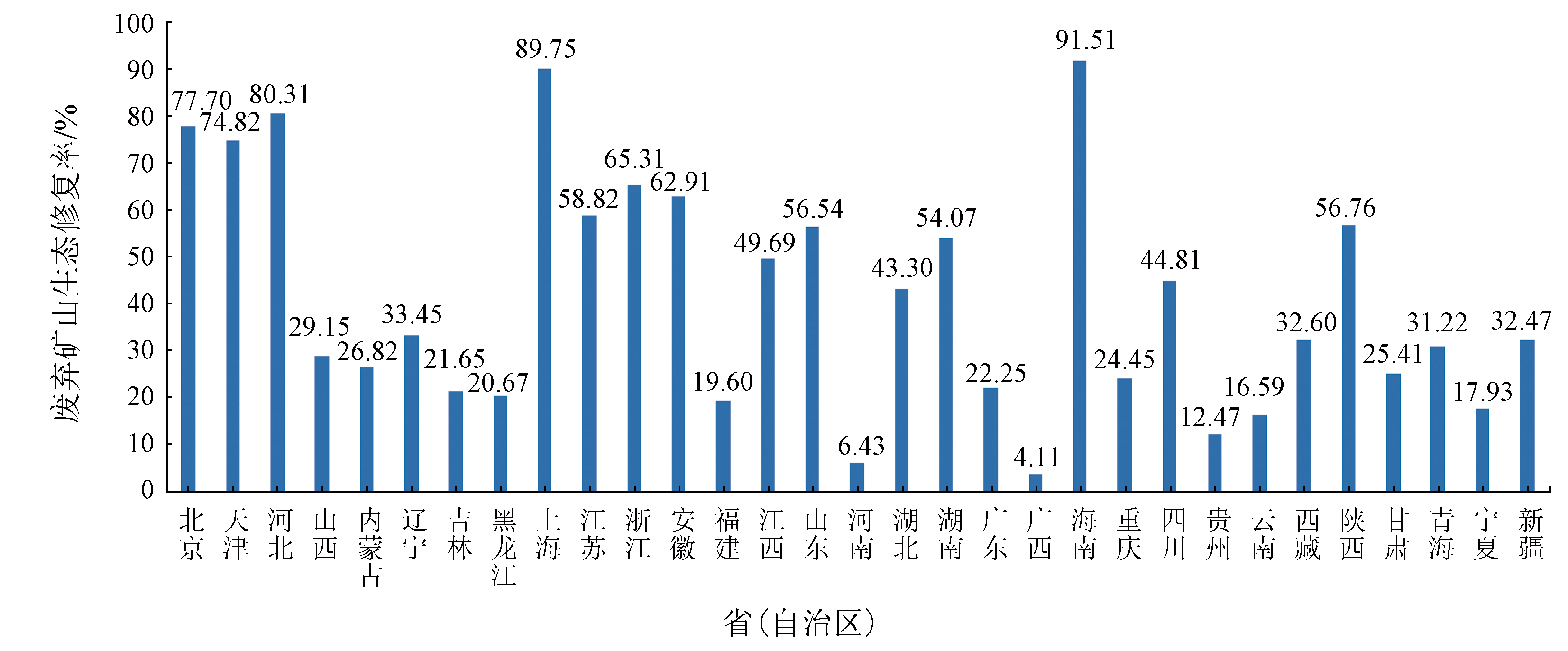
Abstract  

To obtain the fundamental data of mine environments objectively, this study monitored the damaged mining land and the ecological restoration land in abandoned open-pit mines in China by combining remote sensing data with multi-source data, computer automated information extraction with human-computer interactive interpretation, and comprehensive laboratory research with field investigation. The remote sensing monitoring in 2022 shows that the mining land of abandoned open-pit mines in China covered an area of 82.74×10⁴ hm2, representing 0.86‰ of the national land area, primarily distributed in Inner Mongolia and Xinjiang Uygur autonomous regions as well as Hebei, Shandong, and Heilongjiang provinces. Among them, the damaged mining land and the ecological restoration land accounted for 50.74×10⁴ hm2 and 32.00×10⁴ hm2, respectively, with an ecological restoration rate of 38.68%. The mining land of abandoned open-pit mines occupied primary farmland of 2.63×10⁴ hm2, representing 3.18% of the total mining area. The mining land of nationwide abandoned open-pit mines within the ecological red line accounted for 8.09×10⁴ hm2, representing 9.77% of the total mining area. The mining land of nationwide abandoned open-pit mines, coinciding with the result of the third national land resource survey (mining land), totaled 30.13×10⁴ hm2, representing 36.42% of the total mining area. This study preliminarily analyzed the present situation and existing problems of remote sensing work involving the mining land of nationwide abandoned open-pit mines, the occupation of primary farmland, the mining land of such mines within the ecological red line, and corresponding environmental restoration and governance. Finally, this study proposed countermeasures and suggestions in this regard.

Keywords abandoned open-pit mine      mining land      mine ecological restoration      remote sensing monitoring     
ZTFLH:  TP79  
Issue Date: 14 June 2024
Service
E-mail this article
E-mail Alert
RSS
Articles by authors
Yu XING
Jingya WANG
Jinzhong YANG
Dong CHEN
Xiaomin DU
Jingkai GUO
Licong SONG
Cite this article:   
Yu XING,Jingya WANG,Jinzhong YANG, et al. Distributions and existing problems of mining land of abandoned open-pit mines in China[J]. Remote Sensing for Natural Resources, 2024, 36(2): 21-26.
URL:  
https://www.gtzyyg.com/EN/10.6046/zrzyyg.2022440     OR     https://www.gtzyyg.com/EN/Y2024/V36/I2/21
省(自治区) 采矿损毁面积 生态修复面积 总面积 省(自治区) 采矿损毁面积 生态修复面积 总面积
北京 1 123.00 3 913.38 5 036.38 湖北 7 879.62 6 017.04 13 896.66
天津 1 543.22 4 586.69 6 129.91 湖南 10 852.65 12 774.15 23 626.80
河北 14 293.87 58 312.15 72 606.02 广东 16 786.85 4 802.83 21 589.68
山西 26 012.80 10 704.42 36 717.22 广西 21 420.92 917.30 22 338.22
内蒙古 60 316.96 22 104.65 82 421.61 海南 793.34 8 546.94 9 340.28
辽宁 28 892.20 14 524.30 43 416.50 重庆 3 449.54 1 116.51 4 566.05
吉林 15 142.87 4 184.23 19 327.10 四川 4 630.97 3 759.82 8 390.79
黑龙江 44 895.89 11 700.81 56 596.70 贵州 8 544.35 1 217.05 9 761.40
上海 57.31 501.64 558.95 云南 23 291.47 4 631.20 27 922.67
江苏 12 761.81 18 226.00 30 987.81 西藏 5 585.00 2 700.97 8 285.97
浙江 4 926.82 9 275.53 14 202.35 陕西 5 838.10 7 663.11 13 501.21
安徽 8 164.09 13 845.53 22 009.62 甘肃 18 292.15 6 229.99 24 522.14
福建 12 015.85 2 929.74 14 945.59 青海 12 792.89 5 806.55 18 599.44
江西 10 113.76 9 988.84 20 102.60 宁夏 14 595.43 3 189.24 17 784.67
山东 28 650.13 37 267.97 65 918.10 新疆 55 316.15 26 592.57 81 908.72
河南 28 386.44 1 949.75 30 336.19 合计 507 366.45 319 980.90 827 347.35
Tab.1  Statistical table of the mining land for abandoned open-pit mines in China(hm2)
Fig.1  Comparison of ecological rehabilitation of mining land for abandoned open-pit mines in China
[1] 国土资源部. 全国矿产资源规划(2016—2020)[R]. 北京: 国土资源部, 2016.
[1] Ministry of Land and Resources. National mineral resource planning(2016—2020)[R]. Beijing: Ministry of Land and Resources, 2016.
[2] 白中科, 周伟, 王金满, 等. 再论矿区生态系统恢复重建[J]. 中国土地科学, 2018, 32(11):1-9.
[2] Bai Z K, Zhou W, Wang J M, et al. Rethink on ecosystem restoration and rehabilitation of mining areas[J]. China Land Science, 2018, 32(11):1-9.
[3] 杨金中, 聂洪峰, 荆青青. 初论全国矿山地质环境现状与存在问题[J]. 国土资源遥感, 2017, 29(2):1-7.doi:10.6046/gtzyyg.2017.02.01.
[3] Yang J Z, Nie H F, Jing Q Q. Preliminary analysis of mine geo-environment status and existing problems in China[J]. Remote Sensing for Land and Resources, 2017, 29(2):1-7.doi:10.6046/gtzyyg.2017.02.01.
[4] 杨金中, 许文佳, 姚维岭, 等. 全国采矿损毁土地分布与治理状况及存在问题[J]. 地学前缘, 2021, 28(4):83-89.
doi: 10.13745/j.esf.sf.2020.10.8
[4] Yang J Z, Xu W J, Yao W L, et al. Land destroyed by mining in China:Damage distribution,rehabilitation status and existing problems[J]. Earth Science Frontiers, 2021, 28(4):83-89.
[5] 杨金中, 秦绪文, 张志, 等. 矿山遥感监测理论方法与实践[M]. 北京: 测绘出版社, 2011.
[5] Yang J Z, Qin X W, Zhang Z, et al. Theory and practice on remote sensing monitoring of mine[M]. Beijing: Sino Maps Press, 2011.
[6] 杨金中, 秦绪文, 聂洪峰, 等. 中国矿山遥感监测[M]. 北京: 测绘出版社, 2014.
[6] Yang J Z, Qin X W, Nie H F, et al. Remote sensing monitoring of mine in China[M]. Beijing: Sino Maps Press, 2014.
[7] 中华人民共和国国土资源部. DZ/T 0266—2014 矿产资源开发遥感监测技术规范[S]. 北京: 中国标准出版社, 2014.
[7] Ministry of Land and Resources,People’s Republic of China. DZ/T 0266—2014. Regulation on remote sensing monitoring of mining exploration[S]. Beijing: China Standard Press, 2014.
[8] 杨金中, 王晓红, 王海庆, 等. 中国矿山地质环境遥感监测—2017年[M]. 北京: 地质出版社, 2019.
[8] Yang J Z, Wang X H, Wang H Q, et al. Remote sensing monitoring of mine geological environment in China 2017[M]. Beijing: Geological Publishing House, 2019.
[9] 张进德, 郗富瑞. 我国废弃矿山生态修复研究[J]. 生态学报, 2020, 40(21):7921-7930.
[9] Zhang J D, Xi F R. Study on ecological restoration of abandoned mines in China[J]. Acta Ecologica Sinica, 2020, 40(21):7921-7930.
[10] 鞠建华. 构建中国绿色矿山建设的支撑体系[J]. 中国矿业, 2020, 29(1):13-15.
[10] Ju J H. Building the support system of green mine construction in China[J]. China Mining Magazine, 2020, 29(1):13-15.
[1] HE Haixia, LI Bo. Characteristics and risk analysis of the flash flood occurring in Datong of Qinghai Province on August 18, 2022[J]. Remote Sensing for Natural Resources, 2024, 36(2): 135-141.
[2] MA Xiaoxue, JIAO Runcheng, CAO Ying, NAN Yun, WANG Shengyu, GUO Xuefei, ZHAO Danning, YAN Chi, NI Xuan. Application of integrated remote sensing monitoring technology for geological hazards in major engineering construction:A case study of the Yanqing competition area of the Beijing 2022 Olympic Winter Games[J]. Remote Sensing for Natural Resources, 2024, 36(2): 248-256.
[3] ZHOU Xiaojia. Application of remote sensing monitoring in abandoned arable land in a hilly region[J]. Remote Sensing for Natural Resources, 2024, 36(1): 235-241.
[4] YU Hang, AN Na, WANG Jie, XING Yu, XU Wenjia, BU Fan, WANG Xiaohong, YANG Jinzhong. High-resolution remote sensing-based dynamic monitoring of coal mine collapse areas in southwestern Guizhou: A case study of coal mine collapse areas in Liupanshui City[J]. Remote Sensing for Natural Resources, 2023, 35(3): 310-318.
[5] LI Xingyou, ZHANG Fei, WANG Zheng. Present situation and development trend in building remote sensing monitoring models of soil salinization[J]. Remote Sensing for Natural Resources, 2022, 34(4): 11-21.
[6] WANG Juan, WANG Zhihong, ZHANG Jianguo, CHU Na, LI Si, YIN Zhan. Remote sensing monitoring and impact intensity assessment of human activities in Henan national nature reserves[J]. Remote Sensing for Natural Resources, 2022, 34(4): 235-242.
[7] XIN Rongfang, LI Zongren, ZHANG Kun, ZHANG Xing, HUANG Li, LIU Baoshan. Remote sensing monitoring of the dynamic changes in geologic hazards in the Huangshui River basin of Qinghai Province[J]. Remote Sensing for Natural Resources, 2022, 34(4): 254-261.
[8] TONG Jing, YANG Jinzhong, DU Xin, DU Xiaomin, LI Chunbo, AN Na. Remote sensing-based monitoring of the treatment and redevelopment of the brownfields: A case study of brownfields in the risk control and rehabilitation list of Zhejiang Province[J]. Remote Sensing for Natural Resources, 2022, 34(3): 235-239.
[9] ZUO Lu, SUN Leigang, LU Junjing, XU Quanhong, LIU Jianfeng, MA Xiaoqian. MODIS-based comprehensive assessment and spatial-temporal change monitoring of ecological quality in Beijing-Tianjin-Hebei region[J]. Remote Sensing for Natural Resources, 2022, 34(2): 203-214.
[10] CHEN Dong, YAO Weiling. Automatic numbering and method improvement of mine patches based on ArcPy and custom ArcToolbox[J]. Remote Sensing for Land & Resources, 2021, 33(2): 262-269.
[11] WANG Jie, LIU Xiaoyang, YANG Jinzhong, ZHOU Yingjie, An Na, WANG Zhihui. Typical model analysis of mine geological environment restoration and management in Zhejiang Province based on domestic high-resolution satellite data[J]. Remote Sensing for Land & Resources, 2020, 32(3): 216-221.
[12] DIAO Mingguang, LIU Wenjing, LI Jing, LIU Fang, WANG Yanzuo. Dynamic change detection method of vector result data in mine remote sensing monitoring[J]. Remote Sensing for Land & Resources, 2020, 32(3): 240-246.
[13] Haigang SHI, Chunli LIANG, Jianyong ZHANG, Chunlei ZHANG, Xu CHENG. Remote sensing survey of the influence of coastline changes on the thermal discharge in the vicinity of Tianwan Nuclear Power Station[J]. Remote Sensing for Land & Resources, 2020, 32(2): 196-203.
[14] Xi LIU, Lina HAO, Xianhua YANG, Jie HUANG, Zhi ZHANG, Wunian YANG. Research and implementation of rapid statistical methods for mine remote sensing monitoring indicators[J]. Remote Sensing for Land & Resources, 2020, 32(2): 259-265.
[15] Jie WANG, Yaqiu YIN, Hang YU, Cunhao JIANG, Yu WAN. Remote sensing monitoring of mine geological environment in Zhejiang Province based on RS and GIS[J]. Remote Sensing for Land & Resources, 2020, 32(1): 232-236.
Viewed
Full text


Abstract

Cited

  Shared   
  Discussed   
京ICP备05055290号-2
Copyright © 2017 Remote Sensing for Natural Resources
Support by Beijing Magtech