|
|
 |
|

|
|
|
ES change-based ecological restoration zoning for the Hexi region |
HUANG Zhuo1,2,3( ), SUN Jianguo1,2,3(), FENG Chunyue1,2,3, XU Peng4, YANG Hao1,2,3, HOU Wenbing1,2,3 ), SUN Jianguo1,2,3(), FENG Chunyue1,2,3, XU Peng4, YANG Hao1,2,3, HOU Wenbing1,2,3 |
1. Faculty of Geomatics, Lanzhou Jiaotong University, Lanzhou 730070, China
2. National-Local Joint Engineering Research Center of Technologies and Applications for National Geographic State Monitoring, Lanzhou 730070, China
3. Gansu Provincial Engineering Laboratory for National Geographic State Monitoring, Lanzhou 730070, China
4. School of Geoscience and Technology, Southwest Petroleum University, Chengdu 610500, China |
|
|
|
|
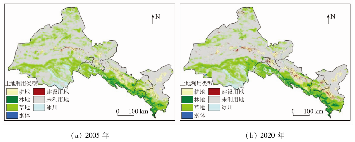
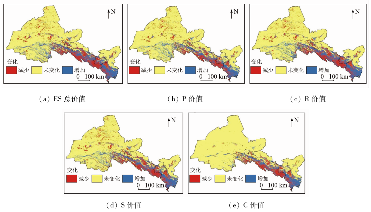
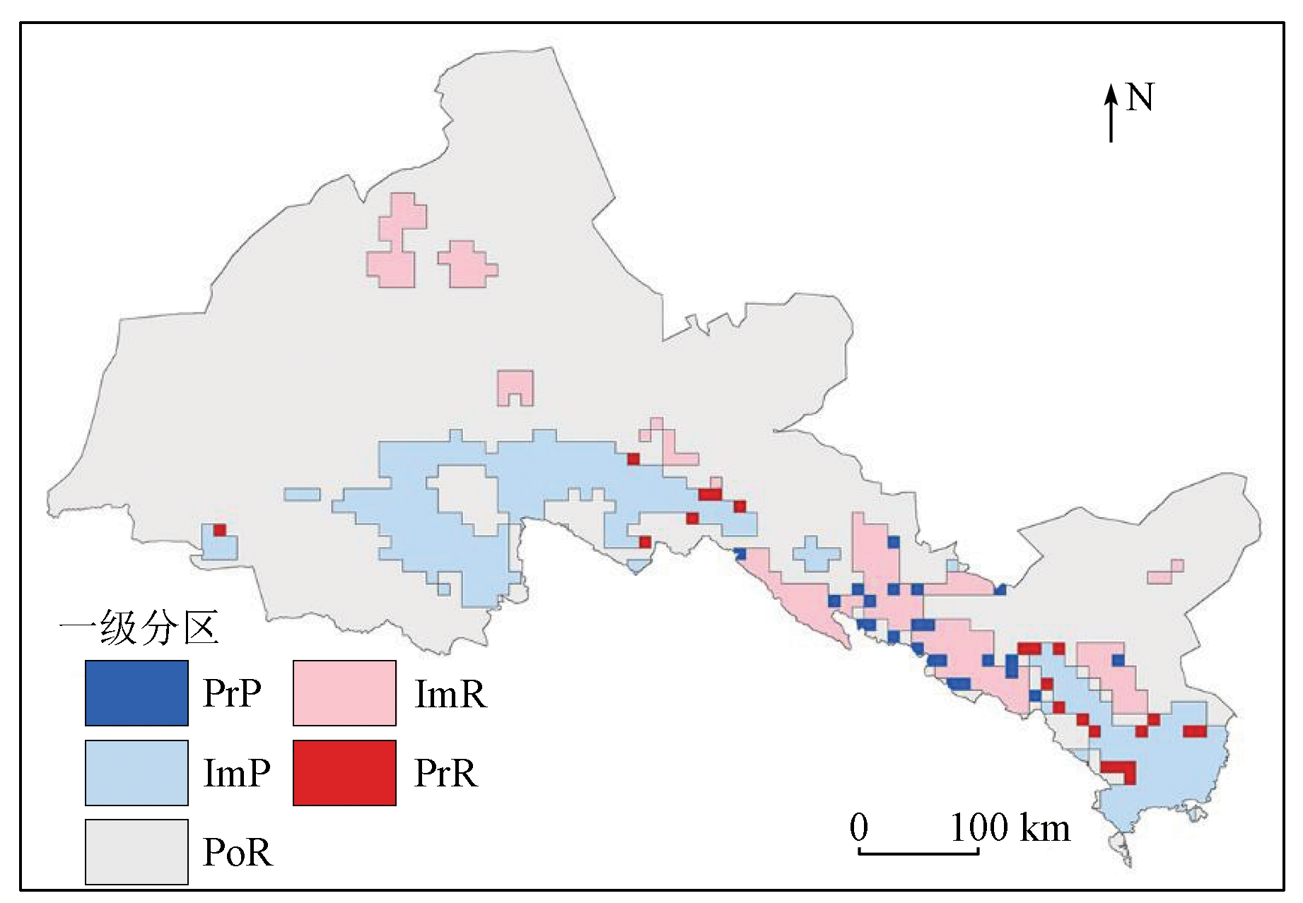
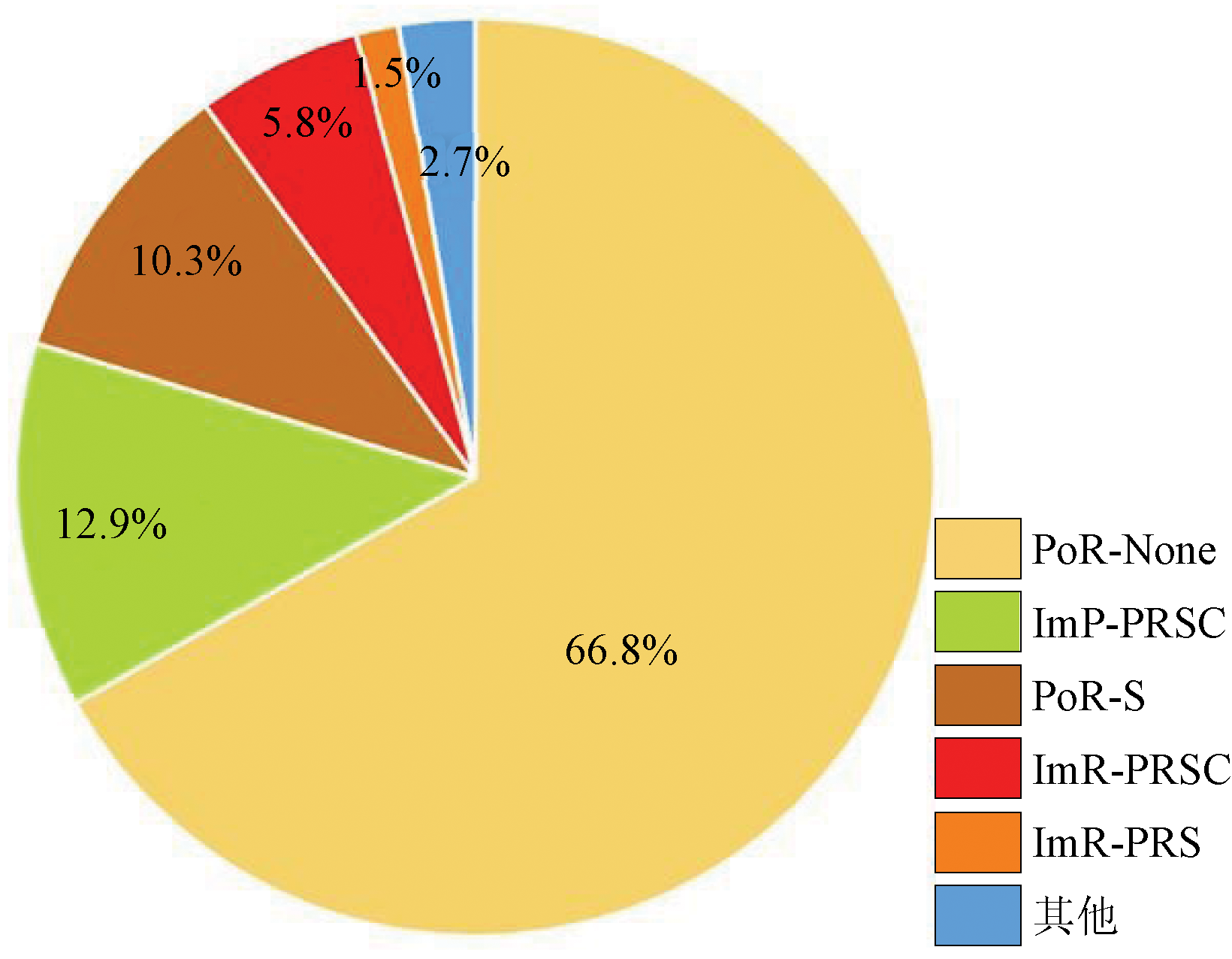
Abstract Ecological restoration zoning is a prerequisite for effective ecological restoration, and currently, the most commonly used zoning method is based on ecosystem services (ES). Most of the previous studies merely focus on the current ES status but ignore its changes, thus failing to reflect the potential and direction of ecological restoration. This study proposed a two-level zoning method for ecological restoration based on ES changes and applied this method to the Hexi region, Gansu Province. First, through Landsat image classification based on the Google Earth Engine (GEE) platform, this study obtained two periods (2005 and 2020) of land use data and calculated the ES sub-value and total value of the two periods of data using the equivalent factor method. Then, this study constructed the level-1 ecological restoration areas (priority restoration area PrR, important restoration area ImR, potential restoration area PoR, important protection area ImP, and priority protection area PrP) through the clustering and outlier analyses of the total ES value changes. Finally, the level-2 ecological restoration zones were determined based on the combined characteristics of changes in the values ES subitems. The results show that: ① Various level-1 areas, i.e., the PrR, ImR, PoR, ImP, and PrP areas account for 0.9%, 7.2%, 78.0%, 13.0%, and 0.9%, respectively. Most of the PoR areas are distributed in the Gobi desert of Hexi region, the PrR and PrP areas are sporadically distributed in the transition zone from the Qilian Mountains to the piedmont grassland, the ImR and ImP zones are mostly distributed in the Qilian Mountains, corridor plains, and mountains in the north. There exit greater potential for the restoration of the ImR areas and the protection of the ImP areas but limited potential for ecological restoration. Furthermore, there is a more urgent need for protection than for restoration; ② The level-2 areas can be classified into 10 categories of restoration areas and six categories of protection areas. The level-2 areas of the ImR and ImP areas are primarily determined based on the synergistic changes in sub-services. Both ecological restoration and protection measures for the Hexi region should focus on the comprehensive enhancement of ES.
|
| Keywords
ES
change
clustering and outlier analysis
ecological restoration zoning
Hexi region
|
|
|
|
Issue Date: 21 December 2023
|
|
|
| [1] |
欧阳志云. 我国生态系统面临的问题与对策[J]. 中国国情国力, 2017(3):6-10.
|
| [1] |
Ouyang Z Y. Problems and countermeasures faced by ecosystems in China[J]. China National Conditions and Strength, 2017(3):6-10.
|
| [2] |
曹宇, 王嘉怡, 李国煜. 国土空间生态修复:概念思辨与理论认知[J]. 中国土地科学, 2019, 33(7):1-10.
|
| [2] |
Cao Y, Wang J Y, Li G Y. Ecological restoration for territorial space:Basic concepts and foundations[J]. China Land Science, 2019, 33(7):1-10.
|
| [3] |
管英杰, 刘俊国, 崔文惠, 等. 中国生态修复研究进展态势分析[J]. 生态学报, 2022, 42(12):1-11.
|
| [3] |
Guan Y J, Liu J G, Cui W H, et al. Progress and future direction of ecological restoration research in China[J]. Acta Ecologica Sinica, 2022, 42(12):1-11.
|
| [4] |
李淑娟, 郑鑫, 隋玉正. 国内外生态修复效果评价研究进展[J]. 生态学报, 2021, 41(10):4240-4249.
|
| [4] |
Li S J, Zheng X, Sui Y Z. Research progress in the evaluation of ecological restoration effects at home and abroad[J]. Acta Ecologica Sinica, 2021, 41(10):4240-4249.
|
| [5] |
刘俊国, 崔文惠, 田展, 等. 渐进式生态修复理论[J]. 科学通报, 2021, 66(9):1014-1025.
|
| [5] |
Liu J G, Cui W H, Tian Z, et al. Theory of stepwise ecological restoration[J]. Chinese Science Bulletin, 2021, 66(9):1014-1025.
|
| [6] |
陈新闯, 李小倩, 吕一河, 等. 区域尺度生态修复空间辨识研究进展[J]. 生态学报, 2019, 39(23):8717-8724.
|
| [6] |
Chen X C, Li X Q, Lyu Y H, et al. Review of spatial identification of ecological restoration[J]. Acta Ecologica Sinica, 2019, 39(23):8717-8724.
|
| [7] |
陈新闯, 李小倩, 吕一河, 等. 生态空间区划体系的理论内涵及关键技术研究[J]. 生态学报, 2022, 42(3):843-850.
|
| [7] |
Chen X C, Li X Q, Lyu Y H, et al. Theoretical and technical discussion on the system of ecological space zoning[J]. Acta Ecologica Sinica, 2022, 42(3):843-850.
|
| [8] |
宋伟, 韩赜, 刘琳. 山水林田湖草生态问题系统诊断与保护修复综合分区研究——以陕西省为例[J]. 生态学报, 2019, 39(23):8975-8989.
|
| [8] |
Song W, Han Z, Liu L. Systematic diagnosis of ecological problems and comprehensive zoning of ecological conservation and restoration for an integrated ecosystem of mountains-rivers-forests-farmlands-lakes-grasslands in Shaanxi Province[J]. Acta Ecologica Sinica, 2019, 39(23):8975-8989.
|
| [9] |
马世发, 劳春华, 江海燕. 基于生态安全格局理论的国土空间生态修复分区模拟——以粤港澳大湾区为例[J]. 生态学报, 2021, 41(9):3441-3448.
|
| [9] |
Ma S F, Lao C H, Jiang H Y. Ecological restoration zoning of territorial space based on the pattern simulation of eco-security scenario:A case study of Guangdong-Hong Kong-Macao Greater Bay Area[J]. Acta Ecologica Sinica, 2021, 41(9):3441-3448.
|
| [10] |
欧阳志云, 王如松, 赵景柱. 生态系统服务功能及其生态经济价值评价[J]. 应用生态学报, 1999, 10(5):635-640.
|
| [10] |
Ouyang Z Y, Wang R S, Zhao J Z. Ecosystem services and their economic valuation[j],Chinese Journal of Applied Ecology, 1999, 10(5):635-640.
|
| [11] |
欧阳志云, 王效科, 苗鸿. 中国陆地生态系统服务功能及其生态经济价值的初步研究[J]. 生态学报, 1999, 19(5):607-613.
|
| [11] |
Ouyang Z Y, Wang X K, Miao H. A primary study on Chinese terrestrial ecosystem services and their ecological-economic values[J], Acta Ecologica Sinica, 1999, 19(5):607-613.
|
| [12] |
岳文泽, 侯丽, 夏皓轩, 等. 基于生态系统服务供需平衡的宁夏固原生态修复分区与优化策略[J]. 应用生态学报, 2022, 33(1):149-158.
doi: 10.13287/j.1001-9332.202112.024
|
| [12] |
Yue W Z, Hou L, Xia H X, et al. Territorially ecological restoration zoning and optimization strategy in Guyuan City of Ningxia,China:Based on the balance of ecosystem service supply and demand[J]. Chinese Journal of Applied Ecology, 2022, 33(1):149-158.
|
| [13] |
刘春芳, 李鹏杰, 刘立程, 等. 西北生态脆弱区省域国土空间生态修复分区[J]. 农业工程学报, 2020, 36(17):254-263.
|
| [13] |
Liu C F, Li P J, Liu L C, et al. Ecological restoration zoning of provincial territorial space in the ecologically fragile areas of Northwest China[J]. Transactions of the Chinese Society of Agricultural Engineering, 2020, 36(17):254-263.
|
| [14] |
Comín F A, Miranda B, Sorando R, et al. Prioritizing sites for ecological restoration based on ecosystem services[J]. Journal of Applied Ecology, 2018, 55(3):1155-1163.
doi: 10.1111/jpe.2018.55.issue-3
url: https://besjournals.onlinelibrary.wiley.com/toc/13652664/55/3
|
| [15] |
倪庆琳, 侯湖平, 丁忠义, 等. 基于生态安全格局识别的国土空间生态修复分区——以徐州市贾汪区为例[J]. 自然资源学报, 2020, 35(1):204-216.
doi: 10.31497/zrzyxb.20200117
|
| [15] |
Ni Q L, Hou H P, Ding Z Y, et al. Ecological remediation zoning of territory based on the ecological security pattern recognition:Taking Jiawang district of Xuzhou City as an example[J]. Journal of Natural Resources, 2020, 35(1):204-216.
doi: 10.31497/zrzyxb.20200117
url: http://www.jnr.ac.cn/EN/10.31497/zrzyxb.20200117
|
| [16] |
丹宇卓, 彭建, 张子墨, 等. 基于“退化压力-供给状态-修复潜力”框架的国土空间生态修复分区——以珠江三角洲为例[J]. 生态学报, 2020, 40(23):8451-8460.
|
| [16] |
Dan Y Z, Peng J, Zhang Z M, et al. Territorially ecological restoration zoning based on the framework of degradation pressure,supply state and restoration potential:A case study in the Pearl River Delta region[J] Acta Ecologica Sinica, 2020, 40(23):8451-8460.
|
| [17] |
付梦娣, 唐文家, 刘伟玮, 等. 基于生态系统服务视角的生态风险评估及生态修复空间辨识——以长江源区为例[J]. 生态学报, 2021, 41(10):3846-3855.
|
| [17] |
Fu M D, Tang W J, Liu W W, et al. Ecological risk assessment and spatial identification of ecological restoration from the ecosystem service perspective:A case study in source region of Yangtze River[J]. Acta Ecologica Sinica, 2021, 41(10):3846-3855.
|
| [18] |
张建永, 李扬, 赵文智, 等. 河西走廊生态格局演变跟踪分析[J]. 水资源保护, 2015, 31(3):5-10.
|
| [18] |
Zhang J Y, Li Y, Zhao W Z, et al. Tracking analysis on changes of ecological patterns in Hexi Corridor Region[J]. Water Resources Protection, 2015, 31(3):5-10.
|
| [19] |
谢丽丽. 河西走廊生态保护修复现状及优化路径[J]. 发展, 2021(7):68-69.
|
| [19] |
Xie L L. Status quo and optimization path of ecological protection and restoration of Hexi Corridor[J]. Developing, 2021(7):68-69.
|
| [20] |
Ge Y, Hu S, Ren Z, et al. Mapping annual land use changes in China’s poverty-stricken areas from 2013 to 2018[J]. Remote Sensing of Environment, 2019, 232:111285.
doi: 10.1016/j.rse.2019.111285
url: https://linkinghub.elsevier.com/retrieve/pii/S0034425719303049
|
| [21] |
Wohlfart C, Mack B, Liu G, et al. Multi-faceted land cover and land use change analyses in the Yellow River Basin based on dense Landsat time series:Exemplary analysis in mining,agriculture,forest,and urban areas[J]. Applied Geography, 2017, 85:73-88.
doi: 10.1016/j.apgeog.2017.06.004
url: https://linkinghub.elsevier.com/retrieve/pii/S014362281630813X
|
| [22] |
谢高地, 张彩霞, 张雷明, 等. 基于单位面积价值当量因子的生态系统服务价值化方法改进[J]. 自然资源学报, 2015, 30(8):1243-1254.
|
| [22] |
Xie G D, Zhang C X, Zhang L M, et al. Improvement of the evaluation method for ecosystem service value based on per unit area[J]. Journal of Natural Resources, 2015, 30(8):1243-1254.
doi: 10.11849/zrzyxb.2015.08.001
|
| [23] |
Robert C, Ralph D, Rudolf D G, et al. The value of the world’s ecosystem services and natural capital[J]. Nature:International Weekly Journal of Science, 1997, 387(6630).
|
| [24] |
欧阳晓, 朱翔, 贺清云. 基于生态系统服务和生态系统健康的生态风险评价——以长株潭城市群为例[J]. 生态学报, 2020, 40(16):5478-5489.
|
| [24] |
Ouyang X, Zhu X, He Q Y. Incorporating ecosystem services with ecosystem health for ecological risk assessment:A case study in Changsha-Zhuzhou-Xiangtan urban agglomeration,China[J]. Acta Ecologica Sinica, 2020, 40(16):5478-5489.
|
| [25] |
Xie G, Zhang C, Zhen L, et al. Dynamic changes in the value of China’s ecosystem services[J]. Ecosystem Services, 2017(26):146-154.
|
| [26] |
舒波, 李雨哲, 王玲, 等. 乐山市土地利用与生态系统服务价值时空动态变化分析[J]. 生态科学, 2022, 41(1):159-168.
|
| [26] |
Shu B, Li Y Z, Wang L, et al. Spatial and temporal dynamic changes of land use and ecosystem service value in Leshan City[J]. Ecological Science, 2022, 41(1):159-168.
|
| [27] |
许长军, 金孙梅, 王英. 基于GIS的青藏高原人居环境自然适宜性评价[J]. 生态科学, 2020, 39(6):93-103.
|
| [27] |
Xu C J, Jin S M, Wang Y. Natural suitability evaluation of human settlements in Qinghai-Tibet Plateau based on GIS[J]. Ecological Science, 2020, 39(6):93-103.
|
| [28] |
李传华, 范也平, 曹红娟, 等. 基于CASA模型的植被第一性生产力人为影响定量研究——以石羊河流域为例[J]. 干旱区地理, 2018, 41(1):142-151.
|
| [28] |
Li C H, Fan Y P, Cao H J, et al. Impact of human activities on net primary productivity based on the CASA model:A case study of the Shiyang River Basin[J]. Arid Land Geography, 2018, 41(1):142-151.
|
| [29] |
杨雪荻, 白永平, 车磊, 等. 甘肃省生态安全时空演变特征及影响因素解析[J]. 生态学报, 2020, 40(14):4785-4793.
|
| [29] |
Yang X D, Bai Y P, Che L, et al. Spatio-temporal evolution and influencing factors of ecological security pattern in Gansu Province[J]. Acta Ecologica Sinica, 2020, 40(14):4785-4793.
|
| [30] |
候启, 张勃, 何航, 等. 近50多年河西地区干热风事件时空变化特征[J]. 干旱区研究, 2019, 36(2):403-411.
|
| [30] |
Hou Q, Zhang B, He H, et al. Spatiotemporal variation of dry-hot wind events in the Hexi region in recent 50 years[J]. Arid Zone Research, 2019, 36(2):403-411.
|
| [31] |
许春娟, 贾生海, 白有帅, 等. 河西走廊荒漠区及水源涵养区水保和人工植被建设刍议[J]. 水利规划与设计, 2022(4):89-92.
|
| [31] |
Xu C J, Jia S H, Bai Y S, et al. Discussion on the construction of water conservation and artificial vegetation in the desert area and water conservation area of the Hexi Corridor[J]. Water Resources Planning and Design, 2022(4):89-92.
|
|
Viewed |
|
|
|
Full text
|
|
|
|
|
Abstract
|
|
|
|
|
Cited |
|
|
|
|
| |
Shared |
|
|
|
|
| |
Discussed |
|
|
|
|
 2023,
Vol. 35
2023,
Vol. 35