|
|
 |
|

|
|
|
Application of mining collapse recognition technology based on multi-source remote sensing |
YANG Xianhua1( ), WEI Peng2, LYU Jun3, HAN Lei1, SHI Haolin1, LIU Zhi1 ), WEI Peng2, LYU Jun3, HAN Lei1, SHI Haolin1, LIU Zhi1 |
1. Sichuan Key Laboratory of Rare Earth Strategic Resources Evaluation and Utilization, Sichuan Geological Survey Institute, Chengdu 610081, China
2. Sichuan Academy of Land and Space Ecological Restoration and Geological Disaster Prevention and Control, Chengdu 610081, China
3. People’s Government of Baodun Town, Chengdu 611438, China |
|
|
|
|
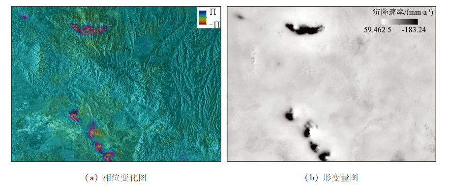
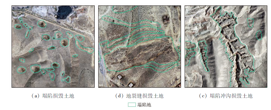
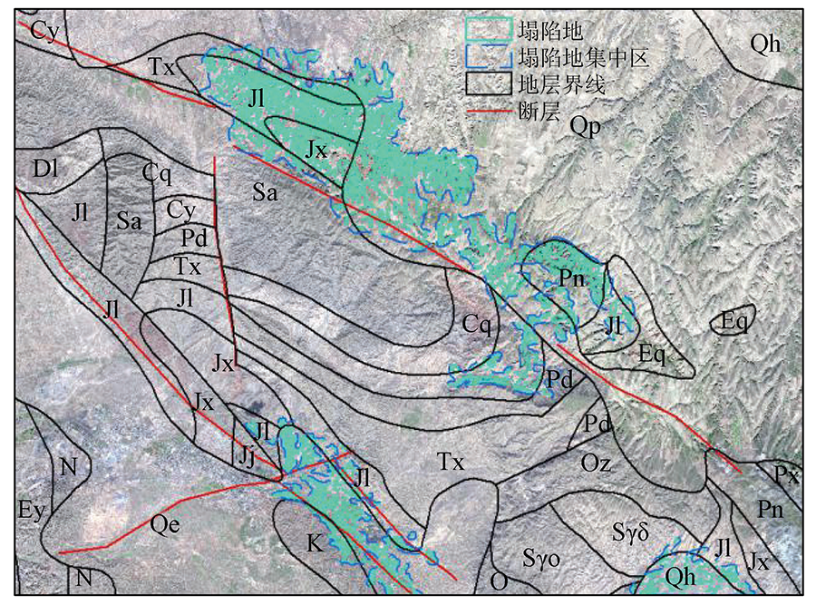
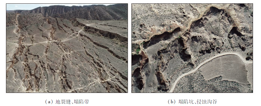
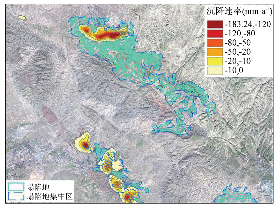
Abstract Mining collapse has caused damage to soil, vegetation, and water resources. With the implementation of the national ecological restoration strategy, it is significant to effectively identify and monitor collapse areas. For this purpose, based on multi-source high-resolution remote sensing images and Sentinel-1 SAR radar images, this study identified and monitored the mining collapses of a coal mine in Baiyin City, Gansu Province using the two technologies, namely the Stacking-InSAR method for extracting ground subsidence data and the human-computer interactive interpretation of optical images of mining collapse. Moreover, this study comprehensively compared the characteristics of both techniques and explored the application prospects of both techniques in the deployment of ecological restoration engineering. The results are as follows: ① The Stacking-InSAR radar monitoring technology can better reflect the deformation during the monitoring period and can effectively identify the mining collapse areas in shallow, middle, and deep coal seams. ② The high-resolution optical image technology can better identify the mining collapse areas in shallow and middle coal seams, more accurately identify the damaged land, and can well identify the historically formed mining collapse areas and damaged land whose collapse deformation has stopped. ③ The collapse deformation and land damage of various stages can be obtained by combining the InSAR monitoring technology and the recognition method base on high-resolution remote sensing images, thus providing detailed and reliable basic data for ecological restoration engineering.
|
| Keywords
mining collapse
high-resolution optical image
Stacking-InSAR
Sentinel-1
ecological restoration
|
|
|
|
Issue Date: 20 June 2022
|
|
|
| [1] |
杨金中, 王晓红, 王海庆, 等. 中国矿山地质环境遥感监测[M]. 北京: 地质出版社, 2019.
|
| [1] |
Yang J Z, Wang X H, Wang H Q, et al. Remote sensing monitoring of mine geological environment in China[M]. Beijing: Geology Press, 2019.
|
| [2] |
葛维琦. 我国采空塌陷区资源城市经济转型对策[J]. 专题探讨, 2004(8):7-9.
|
| [2] |
Ge W Q. Countermeasures for economic transformation of resource cities in goaf subsidence areas in China[J]. Special Discussion, 2004(8):7-9.
|
| [3] |
殷亚秋, 杨金中, 汪洁, 等. 长江经济带废弃矿山占损土地遥感调查与生态修复对策[J]. 国土资源遥感, 2020, 32(2):170-176.doi: 10.6046/gtzyyg.2020.02.22.
doi: 10.6046/gtzyyg.2020.02.22
|
| [3] |
Yin Y Q, Yang T Z, Wang J, et al. Remote sensing survey of land occupied and damaged by abandoned mines along the Yangtze River Economic Belt and research on ecological remediation countermeasures[J]. Remote Sensing for Land and Resources, 2020, 32(2):170-176.doi: 10.6046/gtzyyg.2020.02.22.
doi: 10.6046/gtzyyg.2020.02.22
|
| [4] |
李建勤. 推进矿业城市绿色发展转型发展[J]. 学习与研究, 2018(3):3.
|
| [4] |
Li J Q. Promoting the transformation and development of green development of mining cities[J]. Learning and Research, 2018(3):3.
|
| [5] |
王晓红, 荆青青, 周英杰, 等. 山东省采煤沉陷遥感动态监测[J]. 国土资源遥感, 2017, 29(3):203-210.doi: 10.6046/gtzyyg.2017.03.30.
doi: 10.6046/gtzyyg.2017.03.30
|
| [5] |
Wang X H, Jing Q Q, Zhou Y J, et al. Remote sensing dynamic monitoring of coal mine subsidence disaster in Shandong Province[J]. Remote Sensing for Land and Resources, 2017, 29(3):203-210.doi: 10.6046/gtzyyg.2017.03.30.
doi: 10.6046/gtzyyg.2017.03.30
|
| [6] |
王海庆, 杨金中, 陈玲, 等. 采煤沉陷区恢复治理状况遥感调查[J]. 国土资源遥感, 2017, 29(3):156-162.doi: 10.6046/gtzyyg.2017.03.23.
doi: 10.6046/gtzyyg.2017.03.23
|
| [6] |
Wang H Q, Yang J Z, Chen L, et al. Remote sensing investigation of restoration and management situation in coal mine subsidence areas[J]. Remote Sensing for Land and Resources, 2017, 29(3):156-162.doi: 10.6046/gtzyyg.2017.03.23.
doi: 10.6046/gtzyyg.2017.03.23
|
| [7] |
汪洁, 刘小杨, 杨金中, 等. 基于国产高空间分辨率卫星数据的浙江省矿山环境恢复治理典型模式分析[J]. 国土资源遥感, 2020, 32(3):216-221.doi: 10.6046/gtzyyg.2020.03.28.
doi: 10.6046/gtzyyg.2020.03.28
|
| [7] |
Wang J, Liu X Y, Yang J Z, et al. Typical model analysis of mine geological environment restoration and management in Zhejiang Province based on domestic high-resolution satellite data[J]. Remote Sensing for Land and Resources, 2020, 32(3):216-221.doi: 10.6046/gtzyyg.2020.03.28.
doi: 10.6046/gtzyyg.2020.03.28
|
| [8] |
杨显华, 黄洁, 田立, 等. 矿山遥感监测在采空区稳定性分析中的应用[J]. 国土资源遥感, 2018, 20(3):143-150.doi: 10.6046/gtzyyg.2018.03.20.
doi: 10.6046/gtzyyg.2018.03.20
|
| [8] |
Yang X H, Huang J, Tian L, et al. Application of mine remote sensing monitoring to analysis of mine goaf stability[J]. Remote Sensing for Land and Resources, 2018, 20(3):143-150.doi: 10.6046/gtzyyg.2018.03.20.
doi: 10.6046/gtzyyg.2018.03.20
|
| [9] |
杨显华, 徐肖, 肖礼晓, 等. 察尔汗盐湖演变趋势及驱动力分析[J]. 国土资源遥感, 2020, 32(1):130-137.doi: 10.6046/gtzyyg.2020.01.18.
doi: 10.6046/gtzyyg.2020.01.18
|
| [9] |
Yang X H, Xu X, Xiao L X, et al. Evolution trend and driving force analysis of the Chaerhan Salt Lake[J]. Remote Sensing for Land and Resources, 2020, 32(1):130-137.doi: 10.6046/gtzyyg.2020.01.18.
doi: 10.6046/gtzyyg.2020.01.18
|
| [10] |
吴立新, 高均海, 葛大庆, 等. 工矿区地表沉陷D-InSAR监测实验研究[J]. 东北大学学报: 自然科学版, 2005, 26(8): 778-782.
|
| [10] |
Wu L X, Gao J H, Ge D Q, et al. Experimental study on D-InSAR monitoring of surface subsidence in industrial and mining areas[J]. Journal of Northeast University:Natural Science Edition, 2005, 26 (8):778-782.
|
| [11] |
张晓博, 赵学胜, 葛大庆, 等. 基于Sentinel TOPS模式Stacking技术监测淮南矿区沉降[J]. 国土资源遥感, 2018, 30(4):200-205.doi: 10.6046/gtzyyg.2018.04.30.
doi: 10.6046/gtzyyg.2018.04.30
|
| [11] |
Zhang X B, Zhao X S, Ge D Q, et al. Subsidence monitoring of Huainan coal mine from Sentinel TOPS images based on Stacking technique[J]. Remote Sensing for Land and Resources, 2018, 30(4):200-205.doi: 10.6046/gtzyyg.2018.04.30.
doi: 10.6046/gtzyyg.2018.04.30
|
| [12] |
刘一霖, 张勤, 黄海军, 等. 矿区地表大量级沉陷形变短基线集InSAR监测分析[J]. 国土资源遥感, 2017, 29(2):144-151.doi: 10.6046/gtzyyg.2017.02.21.
doi: 10.6046/gtzyyg.2017.02.21
|
| [12] |
Liu Y L, Zhang Q, Huang H J, et al. Monitoring and analyzing large scale land subsidence over the mining area using small baseline subset InSAR[J]. Remote Sensing for Land and Resources, 2017, 29(2):144-151.doi: 10.6046/gtzyyg.2017.02.21.
doi: 10.6046/gtzyyg.2017.02.21
|
| [13] |
谭庆. 基于Sentinel-1A数据的矿区地面沉降监测应用研究[J]. 地矿测绘, 2019, 35(1):35-38.
|
| [13] |
Tan Q. Application Research of land subsidence monitoring in mining area based on Sentinel-1A data[J]. Geological and Mineral Mapping, 2019, 35(1):35-38.
|
| [14] |
陈亮, 姚顽强, 马润霞, 等. 应用Sentine1-1A卫星数据对宁东煤炭基地进行沉陷监测试验研究[J]. 矿山测量, 2017, 45(3):45-48.
|
| [14] |
Chen L, Yao Z Q, Ma R X, et al. Experimental study on subsidence monitoring of Ningdong coal base using Sentine 1-1A satellite data[J]. Mine Survey, 2017, 45 (3):45-48.
|
| [15] |
罗福乾, 杨建成. 王家山煤矿的灾害链及防治措施[J]. 煤, 2005, 14(5):43-45.
|
| [15] |
Luo F Q, Yang J C. Disaster chain and prevention measures of Wangjiashan coal mine[J]. Coal, 2005, 14(5):43-45.
|
| [16] |
李新, 陶秋香, 宋杨, 等. Sentinel-1A SAR影像及其在矿区地面沉降监测中的应用研究[J]. 测绘与空间地理信息, 2019, 42(3):31-34,38.
|
| [16] |
Li X, Tao Q X, Song Y, et al. Sentinel-1A SAR image and its application in land subsidence monitoring in mining area[J]. Surveying and Spatial Geographic Information, 2019, 42(3):31-34,38.
|
| [17] |
杨金中, 秦绪文, 聂洪峰, 等. 矿山遥感监测工作指南[M]. 北京: 中国大地出版社, 2011.
|
| [17] |
Yang J Z, Qin X W, Nie H F, et al. Mine Remote Sensing Monitoring Work Guide[M]. Beijing: China Land Press, 2011.
|
| [18] |
中国地质调查局. DD2011—06矿产资源开发遥感监测技术要求[S]. 北京: 中国地质调查局, 2011.
|
| [18] |
China Geological Survey. DD2011—06 Technical requirements for remote sensing monitoring of mineral resources development[S]. Beijing: China Geological Survey, 2011.
|
|
Viewed |
|
|
|
Full text
|
|
|
|
|
Abstract
|
|
|
|
|
Cited |
|
|
|
|
| |
Shared |
|
|
|
|
| |
Discussed |
|
|
|
|
 2022,
Vol. 34
2022,
Vol. 34