|
|
|
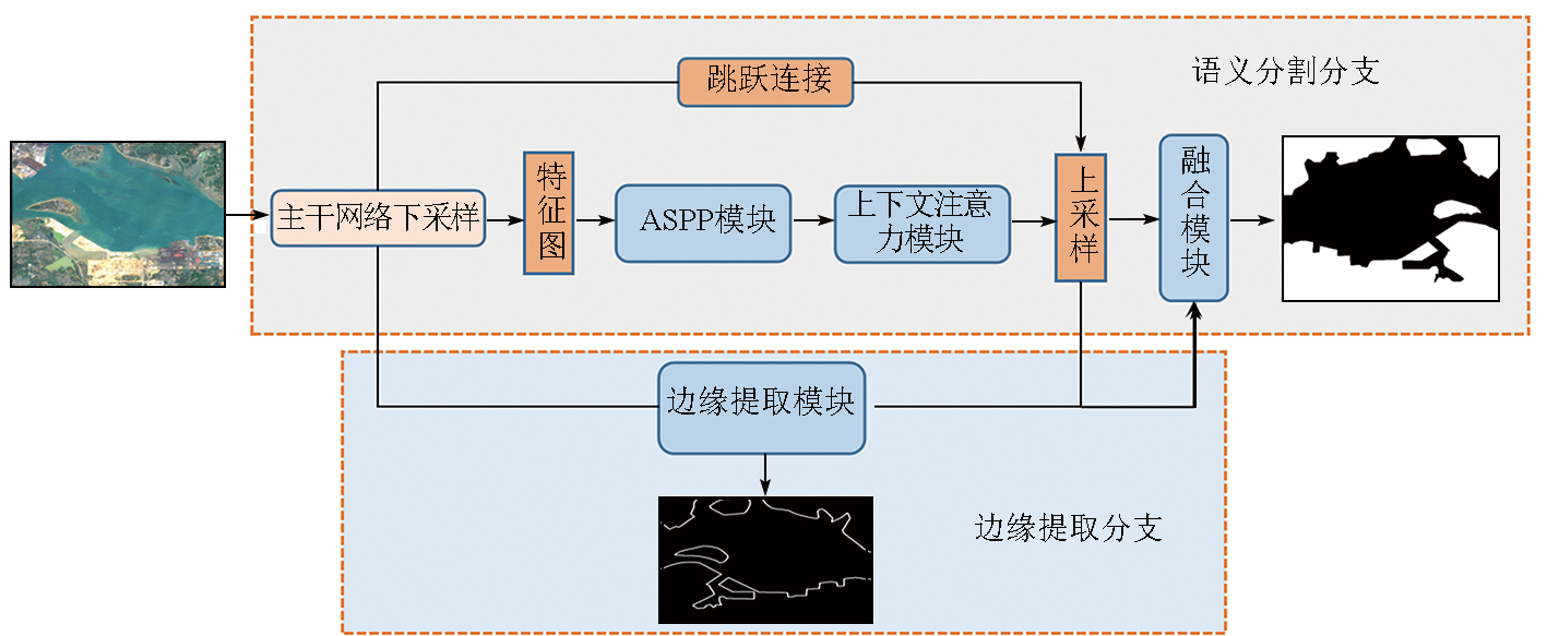
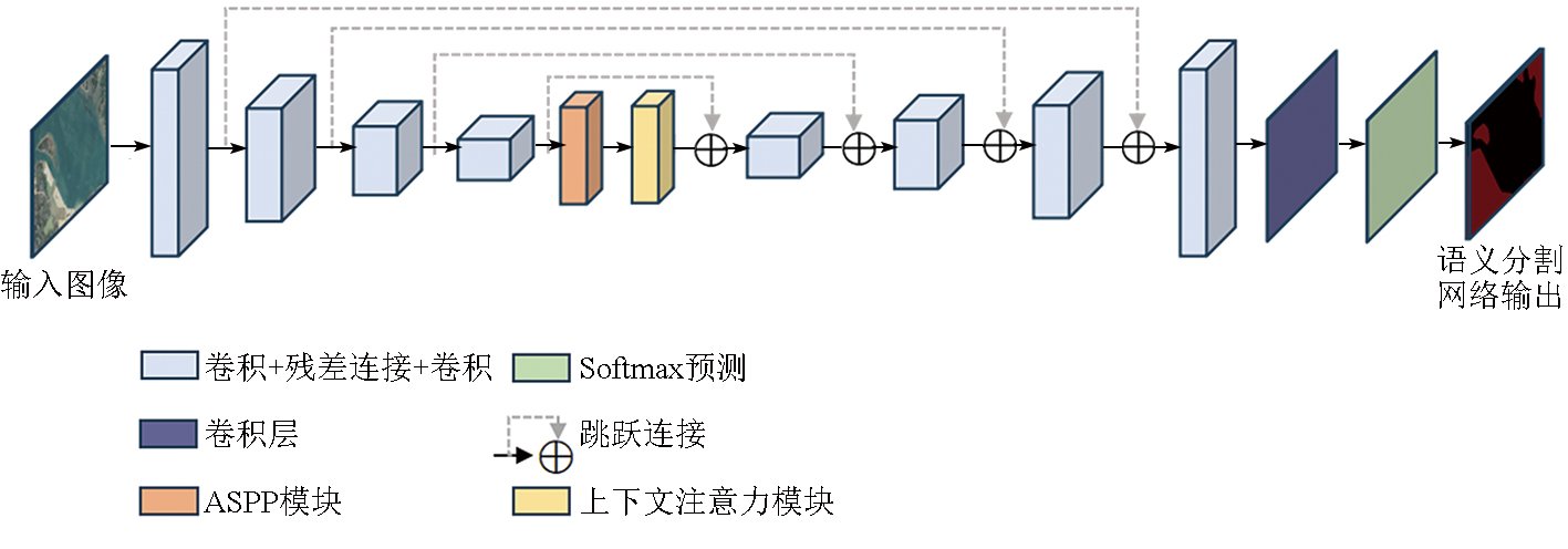
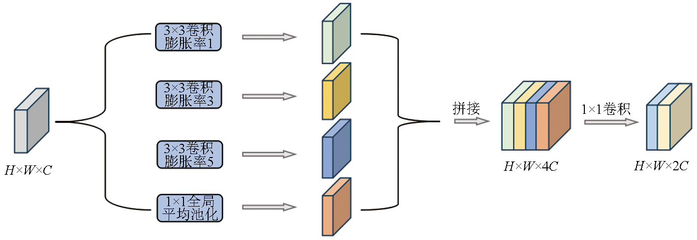
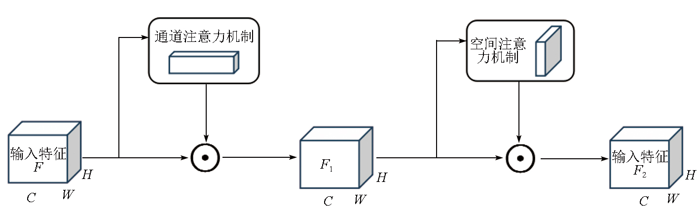
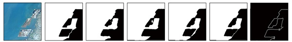
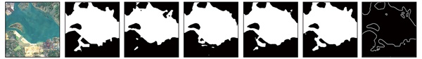
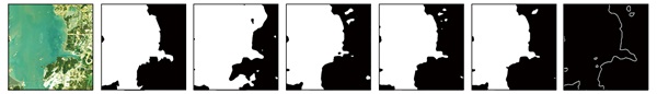
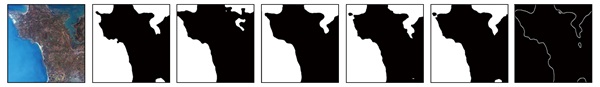
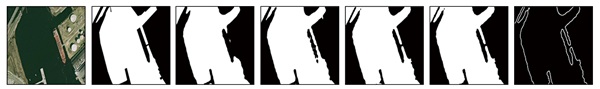
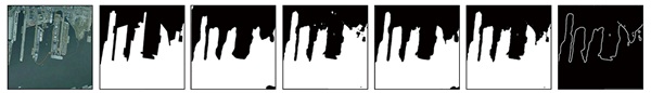
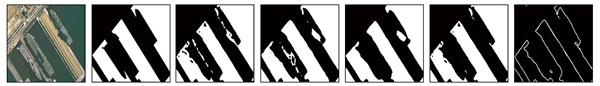
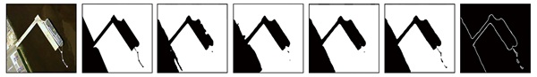
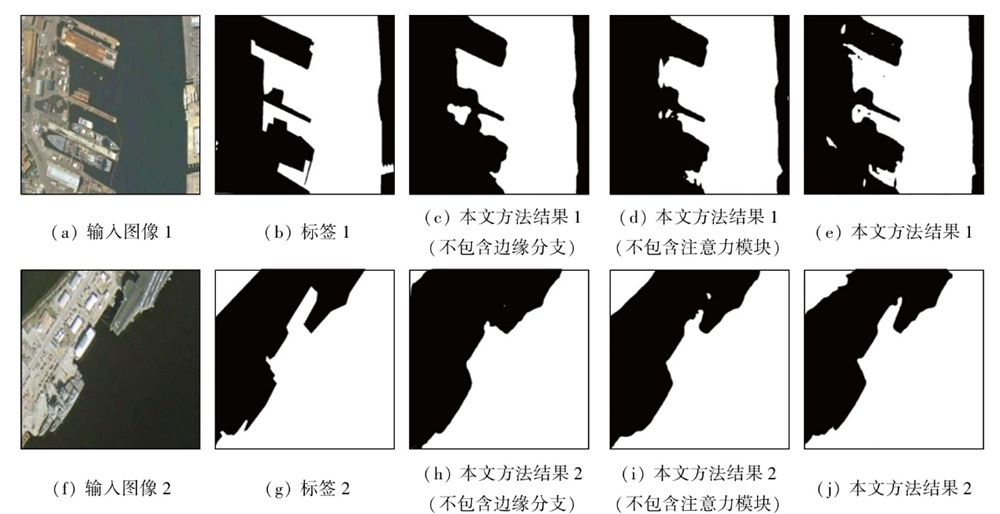
Abstract In optical remote sensing images with complex scenes and rich land cover information,the sea-land segmentation faces challenges such as low positioning accuracy and blurred edges. Therefore,this paper proposed a deep convolutional network model and a sea-land segmentation method that integrate contextual semantic information and edge features. First,the rich target semantic information was extracted from remote sensing images using the FusionNet semantic segmentation network module. Then,multi-scale and hierarchical contextual semantic features were extracted from the segmentation network using the enhanced atrous spatial pyramid pooling (ASPP) module and contextual attention module. Additionally,an edge extraction sub-network was built to extract multi-scale edge features. Finally,the semantic features and edge features were combined through a fusion module,thereby achieving accurate sea-land segmentation. This method was tested with two typical representative datasets. The results showed that this method achieved an overall prediction accuracy of 98.21%,an F1 score of 97.64%,and a boundary F1 score of 89.36%,all significantly outperforming other models. Particularly in complex backgrounds,this method can effectively improve the accuracy of segmentation and edge detection,demonstrating definite advantages in the segmentation of artificial coastlines and ports.
|
| Keywords
sea-land segmentation
edge extraction
semantic segmentation
multi-task learning
contextual attention module
|
|
|
|
Issue Date: 28 October 2025
|
|
|
| [1] |
Liu G, Zhang Y S, Zheng X W, et al. A new method on inshore ship detection in high-resolution satellite images using shape and context information[J]. IEEE Geoscience and Remote Sensing Letters, 2014, 11(3):617-621.
|
| [2] |
Zhu C R, Zhou H, Wang R S, et al. A novel hierarchical method of ship detection from spaceborne optical image based on shape and texture features[J]. IEEE Transactions on Geoscience and Remote Sensing, 2010, 48(9):3446-3456.
|
| [3] |
Ji X, Tang L B, Lu T W, et al. DBENet:Dual-branch ensemble network for sea-land segmentation of remote-sensing images[J]. IEEE Transactions on Instrumentation and Measurement, 2023, 72:5503611.
|
| [4] |
陈祥, 孙俊, 尹奎英, 等. 基于Otsu与海域统计特性的SAR图像海陆分割算法[J]. 数据采集与处理, 2014, 29(4):603-608.
|
| [4] |
Chen X, Sun J, Yin K Y, et al. Sea-land segmentation algorithm of SAR image based on Otsu method and statistical characteristic of sea area[J]. Journal of Data Acquisition and Processing, 2014, 29(4):603-608.
|
| [5] |
李业钦, 王常颖, 隋毅, 等. 基于自动阈值分类的高分辨率影像海陆分界线自动提取[J]. 遥感技术与应用, 2021, 36(6):1379-1387.
doi: 10.11873/j.issn.1004-0323.2021.6.1379
|
| [5] |
Li Y Q, Wang C Y, Sui Y, et al. Automatic extraction of the sea-land boundary from high spatial resolution images based on automatic threshold segmentation[J]. Remote Sensing Technology and Application, 2021, 36(6):1379-1387.
|
| [6] |
梁新宇, 罗晨, 权冀川, 等. 基于深度学习的图像语义分割技术研究进展[J]. 计算机工程与应用, 2020, 56(2):18-28.
doi: 10.3778/j.issn.1002-8331.1910-0300
|
| [6] |
Liang X Y, Luo C, Quan J C, et al. Research on progress of image semantic segmentation based on deep learning[J]. Computer Engineering and Applications, 2020, 56(2):18-28.
doi: 10.3778/j.issn.1002-8331.1910-0300
|
| [7] |
马妍, 古丽米拉·克孜尔别克. 图像语义分割方法在高分辨率遥感影像解译中的研究综述[J]. 计算机科学与探索, 2023, 17(7):1526-1548.
doi: 10.3778/j.issn.1673-9418.2211015
|
| [7] |
Ma Y, Gulimila·K. Research review of image semantic segmentation method in high-resolution remote sensing image interpretation[J]. Journal of Frontiers of Computer Science and Technology, 2023, 17(7):1526-1548.
|
| [8] |
Lei S, Zou Z X, Liu D G, et al. Sea-land segmentation for infrared remote sensing images based on superpixels and multi-scale features[J]. Infrared Physics & Technology, 2018, 91:12-17.
|
| [9] |
Elkhateeb E, Soliman H, Atwan A, et al. A novel coarse-to-fine sea-land segmentation technique based on superpixel fuzzy C-means clustering and modified Chan-Vese model[J]. IEEE Access, 2021, 9:53902-53919.
|
| [10] |
Kalchbrenner N, Grefenstette E, Blunsom P. A convolutional neural network for modelling sentences[C]// Proceedings of the 52nd Annual Meeting of the Association for Computational Linguistics. Association for Computational Linguistics,2014:655-665.
|
| [11] |
Ronneberger O, Fischer P, Brox T. U-Net:Convolutional networks for biomedical image segmentation[C]//Medical Image Computing and Computer-Assisted Intervention-MICCAI 2015.Springer International Publishing,2015:234-241.
|
| [12] |
Badrinarayanan V, Kendall A, Cipolla R. SegNet:A deep convolutional encoder-decoder architecture for image segmentation[J]. IEEE Transactions on Pattern Analysis and Machine Intelligence, 2017, 39(12):2481-2495.
doi: 10.1109/TPAMI.2016.2644615
pmid: 28060704
|
| [13] |
Zhao H S, Shi J P, Qi X J, et al. Pyramid scene parsing network[C]//2017 IEEE Conference on Computer Vision and Pattern Recognition (CVPR). IEEE, 2017:6230-6239.
|
| [14] |
Wu X Y, Chen G, Ding X Q, et al. Multiscale deep fully convolutional network for sea-land segmentation of surveillance images[C]//2020 International Conference on Image,Video Processing and Artificial Intelligence. SPIE, 2020:29-35.
|
| [15] |
Ji X, Tang L B, Liu T H, et al. HeteroNet:A heterogeneous encoder-decoder network for sea-land segmentation of remote sensing im-ages[J]. Journal of Electronic Imaging, 2023, 32(5):053016.
|
| [16] |
Zhao L, Zhang Y S, Xue W, et al. Fast and accurate sea-land segmentation of SAR imagery based on multi-source data registration[J]. Geocarto International, 2022, 37(26):13748-13768.
|
| [17] |
Gao P, Tian J W. A novel model for edge aware sea-land segmentation[C]//MIPPR 2019: Remote Sensing Image Processing,Geographic Information Systems,and Other Applications. SPIE,2020:107-114.
|
| [18] |
梁烽, 张瑞祥, 柴英特, 等. 一种结合上下文与边缘注意力的SAR图像海陆分割深度网络方法[J]. 武汉大学学报(信息科学版), 2023, 48(8):1286-1295.
|
| [18] |
Liang F, Zhang R X, Chai Y T, et al. A sea-land segmentation method for SAR images using context-aware and edge attention based CNNs[J]. Geomatics and Information Science of Wuhan University, 2023, 48(8):1286-1295.
|
| [19] |
Chen L, Papandreou G, Schroff F, et al. Rethinking atrous convolution for semantic image segmentation[J/OL]. arXiv, 2017(2017-06-17). http://arxiv.org/abs/1706.05587.
url: http://arxiv.org/abs/1706.05587
|
| [20] |
Quan T M, Hildebrand D G C, Jeong W K. FusionNet:A deep fully residual convolutional neural network for image segmentation in connectomics[J]. Frontiers in Computer Science, 2021, 3:613981.
|
| [21] |
He K M, Zhang X Y, Ren S Q, et al. Deep re-sidual learning for image recognition[C]//2016 IEEE Conference on Computer Vision and Pattern Recognition (CVPR). IEEE, 2016:770-778.
|
| [22] |
Woo S, Park J, Lee J Y, et al. CBAM:Convolutional block attention module[C]// Computer Vision-ECCV 2018.Springer International Publishing,2018:3-19.
|
| [23] |
Vaswani A, Shazeer N, Parmar N, et al. Attention is all you need[C]//31st Annual Conference on Neural Information Processing Systems (NIPS).ACM,2017:6000-6010.
|
| [24] |
杨先增, 周亚男, 张新, 等. 融合边缘特征与语义信息的人工坑塘精准提取方法[J]. 地球信息科学学报, 2022, 24(4):766-779.
doi: 10.12082/dqxxkx.2022.210489
|
| [24] |
Yang X Z, Zhou Y N, Zhang X, et al. Accurate extraction of artificial pit-pond integrating edge features and semantic information[J]. Journal of Geo-Information Science, 2022, 24(4):766-779.
|
| [25] |
Zhang Y, Liu F G, Tang Q. Utilize spatial prior in ground truth:Spatial-enhanced loss for semantic segmentation[C]// Artificial Neural Networks and Machine Learning-ICANN 2022.Springer Nature Switzerland,2022:312-321.
|
| [26] |
Li X Y, Sun X F, Meng Y X, et al. Dice loss for data-imbalanced NLP tasks[C]// Proceedings of the 58th Annual Meeting of the Association for Computational Linguistics. Association for Computational Linguistics,2020:465-476.
|
| [27] |
Salehi S S M, Erdogmus D, Gholipour A. Tversky loss function for image segmentation using 3D fully convolutional deep networks[C]// Machine Learning in Medical Imaging. Springer International Publishing,2017:379-387.
|
| [28] |
Lin T Y, Goyal P, Girshick R, et al. Focal loss for dense object detection[J]. IEEE Transactions on Pattern Analysis and Machine Intelligence, 2020, 42(2):318-327.
|
| [29] |
Kervadec H, Bouchtiba J, Desrosiers C, et al. Boundary loss for highly unbalanced segmentation[J]. Medical Image Analysis, 2021, 67:101851.
|
| [30] |
Yang T, Jiang S L, Hong Z H, et al. Sea-land segmentation using deep learning techniques for Landsat8 OLI imagery[J]. Marine Geodesy, 2020, 43(2):105-133.
|
| [31] |
Liu Z K, Yuan L, Weng L B, et al. A high resolution optical satellite image dataset for ship recognition and some new baselines[C]// Proceedings of the 6th International Conference on Pattern Recognition Applications and Methods. SciTePress,2017:324-331.
|
|
Viewed |
|
|
|
Full text
|
|
|
|
|
Abstract
|
|
|
|
|
Cited |
|
|
|
|
| |
Shared |
|
|
|
|
| |
Discussed |
|
|
|
|
 2025,
Vol. 37
2025,
Vol. 37
 ), PU Yunwei1,2(