|
|
 |
|

|
|
|
Trend analysis and prediction method of ground deformation using TS-InSAR-based combination-long short-term memory |
WEN Yi1,2,3,4( ), ZHANG Ling1,2,3, KONG Hanquan5, WAN Xiangxing1,2,3(), GE Daqing1,2,3, LIU Bin1,2,3 ), ZHANG Ling1,2,3, KONG Hanquan5, WAN Xiangxing1,2,3(), GE Daqing1,2,3, LIU Bin1,2,3 |
1. China Aero Geophysical Survey and Remote Sensing Center for Natural Resources,Beijing 100083,China
2. Key Laboratory of Airborne Geophysics and Remote Sensing Geology,Ministry of Natural Resources,Beijing 100083,China
3. Technology Innovation Center for Geohazard Identification and Monitoring with Earth Observation System,Ministry of Natural Resources,Beijing 100083,China
4. School of Geosciences and Surveying Engineering,China University of Mining and Technology (Beijing) 100083,China
5. Heilongjiang Institute of Geological Mapping and Geographic Information,Harbin 150030,China |
|
|
|
|
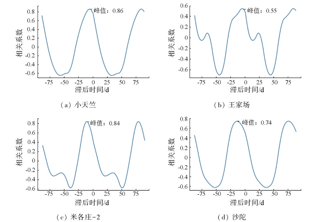
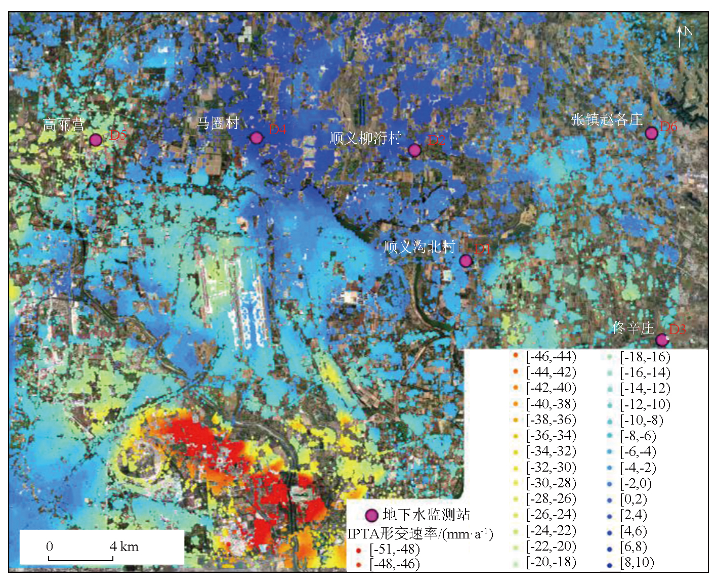
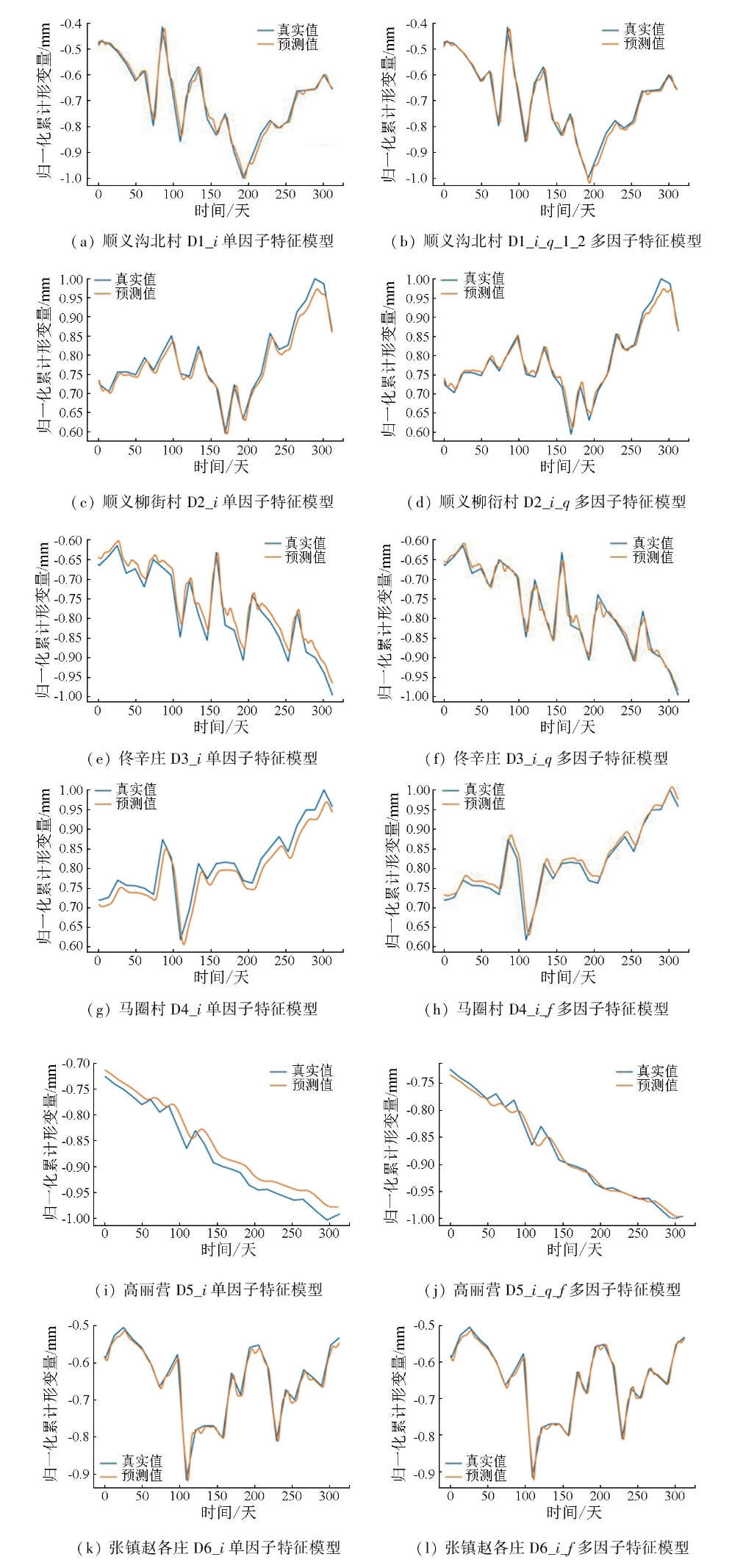
Abstract Time-series interferometric synthetic aperture radar (TS-InSAR) technology has been widely used in ground deformation monitoring and prediction. However,current research remains insufficient in the correlation and temporal lag between groundwater and ground deformation. Moreover,InSAR-based prediction models for ground deformation mostly rely on a single InSAR data,which limits the prediction accuracy and generalization ability of the models. To address these challenges,this study proposed a combination-long short-term memory (C-LSTM) model that integrates groundwater level,rainfall,and InSAR deformation data. This model was employed to evaluate the prediction and accuracy of single-factor and multi-factor models,respectively. The results revealed a temporal lag between ground deformation and changes in groundwater level. The optimal feature combination,obtained through model training using groundwater and rainfall data,exhibited significant improvements in prediction accuracy compared to single-factor predictions,with the coefficient of determination (R2) increasing by 2.45%,1.52%,4.16%,8.08%,5.08%,and 1.45% respectively. The model enhances the prediction accuracy of ground deformation by incorporating model feature combinations with high correlation with ground deformation.
|
| Keywords
time-series interferometric synthetic aperture radar (TS-InSAR)
ground deformation
correlation analysis
combination-long short-term memory (C-LSTM)
|
|
|
|
Issue Date: 28 October 2025
|
|
|
| [1] |
Dai K, Shi X, Gou J, et al. Diagnosing subsidence geohazard at Beijing capital international airport,from high-resolution SAR interferometry[J]. Sustainability, 2020, 12(6):2269.
|
| [2] |
Lu Z, Yang H, Zeng W, et al. Geological hazard identification and susceptibility assessment based on MT-InSAR[J]. Remote Sensing, 2023, 15(22):5316.
|
| [3] |
田芳, 罗勇, 周毅, 等. 北京地面沉降与地下水开采时空演变对比[J]. 南水北调与水利科技, 2017, 15(2):163-169.
|
| [3] |
Tian F, Luo Y, Zhou Y, et al. Contrastive analysis of spatial-temporal evolution between land subsidence and groundwater exploitation in Beijing[J]. South-to-North Water Transfers and Water Science and Technology, 2017, 15(2):163-169.
|
| [4] |
Zhang Z, Hu C, Wu Z, et al. Monitoring and analysis of ground subsidence in Shanghai based on PS-InSAR and SBAS-InSAR technologies[J]. Scientific Reports, 2023, 13(1):8031.
doi: 10.1038/s41598-023-35152-1
pmid: 37198287
|
| [5] |
Shi J, Wang Z, Zhang Z, et al. Assessment of deep groundwater over-exploitation in the North China plain[J]. Geoscience Frontiers, 2011, 2(4):593-598.
|
| [6] |
Chen B, Gong H, Chen Y, et al. Land subsidence and its relation with groundwater aquifers in Beijing Plain of China[J]. Science of the Total Environment, 2020, 735:139111.
|
| [7] |
Li Z H, Yu C, Xiao R Y, et al.. Entering a new era of InSAR:Advanced techniques and emerging applications[J]. Journal of Geodesy and Geoinformation Science, 2022, 5(1):1-4.
|
| [8] |
Zhang L, Dai K, Deng J, et al. Identifying potential landslides by stacking-InSAR in southwestern China and its performance comparison with SBAS-InSAR[J]. Remote Sensing, 2021, 13(18):3662.
|
| [9] |
Zhang Y, Zhang J, Wu H, et al. Monitoring of urban subsidence with SAR interferometric point target analysis:A case study in Suzhou,China[J]. International Journal of Applied Earth Observation and Geoinformation, 2011, 13(5):812-818.
|
| [10] |
Lattari F, Rucci A, Matteucci M. A deep learning approach for change points detection in InSAR time series[J]. IEEE Transactions on Geoscience and Remote Sensing, 2022, 60:1-16.
|
| [11] |
Koutník J, Greff K, Gomez F, et al. A Clockwork RNN[J]. Computer Science, 2014,1863-1871
|
| [12] |
刘明坤, 贾三满, 褚宏亮. 北京市地面沉降监测系统及技术方法[J]. 地质与资源, 2012, 21(2):244-249.
|
| [12] |
Liu M K, Jia S M, Chu H L. The monitoring system and technologies of land subsidence in Beijing[J]. Geology and Resources, 2012, 21(2):244-249.
|
| [13] |
Hu B, Wang H S, Sun Y L, et al. Long-term land subsidence monitoring of Beijing (China) using the small baseline subset (SBAS) technique[J]. Remote Sensing, 2014, 6(5):3648-3661.
|
| [14] |
雷坤超. 南水北调前后北京平原区地下水和地面沉降演变特征[J]. 地质学报, 2024, 98(2):591-610.
|
| [14] |
Lei K C. Characteristics of groundwater and land subsidence evolution before and after the South-to-North Water Diversion Project in Beijing,China[J]. Acta Geologica Sinica, 2024, 98(2):591-610.
|
|
Viewed |
|
|
|
Full text
|
|
|
|
|
Abstract
|
|
|
|
|
Cited |
|
|
|
|
| |
Shared |
|
|
|
|
| |
Discussed |
|
|
|
|
 2025,
Vol. 37
2025,
Vol. 37