|
|
|
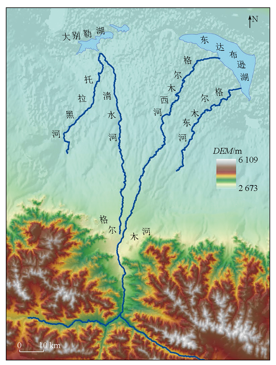
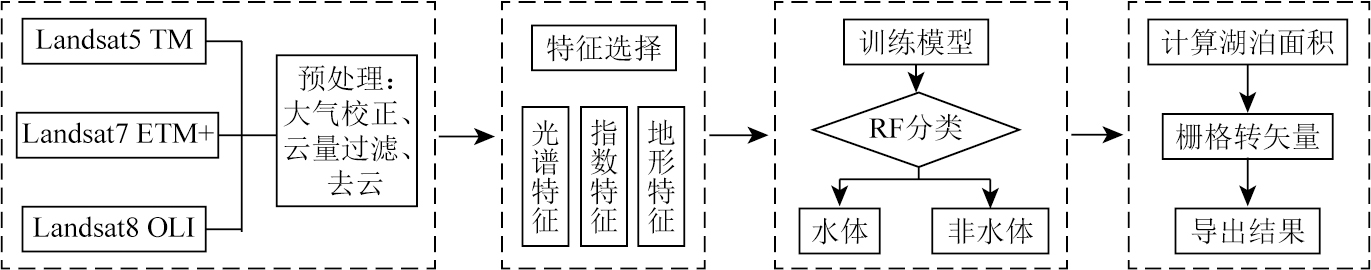
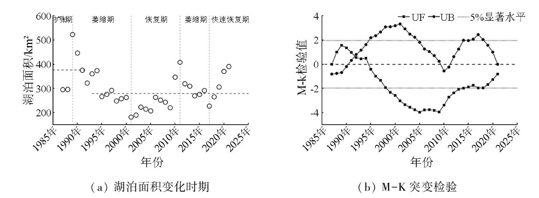
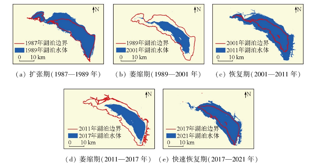
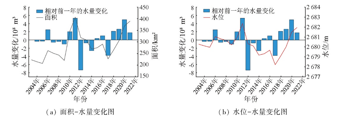
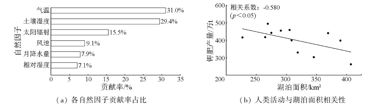
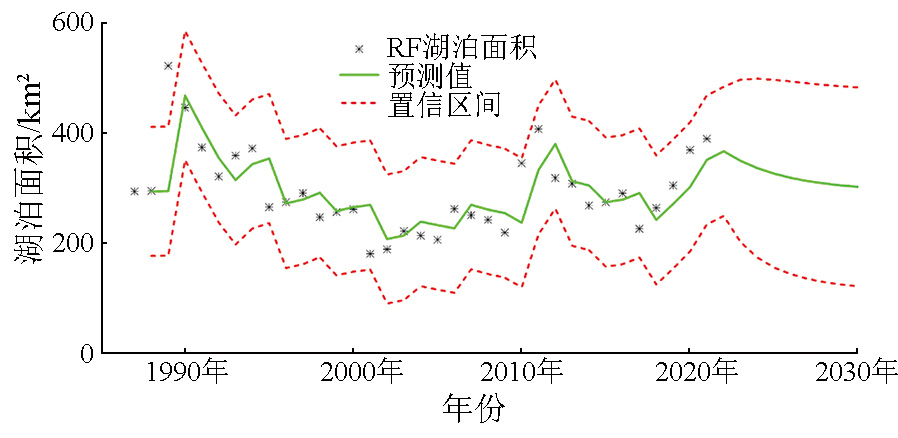
Abstract Changes in lake area and water volume exert significant impacts on the ecological environment of arid regions. Targeting East Dabuxun Lake,Golmud River Basin,Qinghai Province,this study developed a multi-index random forest algorithm based on the Google Earth Engine (GEE) cloud platform and Landsat imagery to extract the lake area from 1987 to 2021. Then,an area-water level relationship was established using laser altimetry data from ICESat and CryoSat satellites to estimate changes in water volume. Finally,the impacts of natural factors and human activities on the lake were evaluated,using ERA5-Land climate data and records of potash mining,along with correlation analysis and random forest-based contribution assessment. The results indicate that the temporal changes in lake area over time can be divided into five stages:expansion,shrinkage,recovery,re-shrinkage,and rapid recovery. Spatially,the lake exhibited a pattern of shrinkage in the south and expansion towards the northwest. From 2003 to 2021,the water volume of East Dabuxun Lake showed an upward trend. Temperature,glacier and permafrost melting,and solar radiation were identified as the main natural factors influencing lake area,with contribution rates of 31.0%,29.4%,and 15.5%,respectively. In terms of human activities,potash mining emerged as a major driver of lake area changes after 2010. Based on predictions by the auto-regressive moving average model (ARIMA),the lake area is projected to decline to 302.78 km2 by 2030.
|
| Keywords
random forest
lake water volume estimation
correlation analysis
lake area prediction
East Dabuxun Lake
|
|
|
|
Issue Date: 28 October 2025
|
|
|
| [1] |
Mason I M, Guzkowska M A J, Rapley C G, et al. The response of lake levels and areas to climatic change[J]. Climatic Change, 1994, 27(2):161-197.
|
| [2] |
李丹, 吴保生, 陈博伟, 等. 基于卫星遥感的水体信息提取研究进展与展望[J]. 清华大学学报(自然科学版), 2020, 60(2):147-161.
doi: 10.16511/j.cnki.qhdxxb.2019.22.038
|
| [2] |
Li D, Wu B S, Chen B W, et al. Review of water body information extraction based on satellite remote sensing[J]. Journal of Tsinghua University (Science and Technology), 2020, 60(2):147-161.
|
| [3] |
Wang D, Huo Z L, Miao P, et al. Comparison of machine learning models to predict lake area in an arid area[J]. Remote Sensing, 2023, 15(17):4153.
|
| [4] |
Xia H M, Zhao J Y, Qin Y C, et al. Changes in water surface area during 1989—2017 in the Huai River Basin using landsat data and Google Earth Engine[J]. Remote Sensing, 2019, 11(15):1824.
|
| [5] |
徐涵秋. 水体遥感指数研究进展[J]. 福州大学学报(自然科学版), 2021, 49(5):613-625.
|
| [5] |
Xu H Q. Development of remote sensing water indices:A review[J]. Journal of Fuzhou University (Natural Science Edition), 2021, 49(5):613-625.
|
| [6] |
Zhou Y, Dong J W, Xiao X M, et al. Continuous monitoring of lake dynamics on the Mongolian Plateau using all available Landsat imagery and Google Earth Engine[J]. Science of the Total Environment, 2019, 689:366-380.
doi: 10.1016/j.scitotenv.2019.06.341
|
| [7] |
Li X S, Zhang D H, Jiang C C, et al. Comparison of lake area extraction algorithms in Qinghai Tibet Plateau leveraging Google Earth Engine and Landsat-9 data[J]. Remote Sensing, 2022, 14(18):4612.
|
| [8] |
Yang Y P, Yang D, Wang X F, et al. Testing accuracy of land cover classification algorithms in the Qilian Mountains based on GEE cloud platform[J]. Remote Sensing, 2021, 13(24):5064.
|
| [9] |
Rao P Z, Jiang W G, Hou Y K, et al. Dynamic change analysis of surface water in the Yangtze River Basin based on MODIS products[J]. Remote Sensing, 2018, 10(7):1025.
|
| [10] |
Liu C, Hu R H, Wang Y F, et al. Monitoring water level and volume changes of lakes and reservoirs in the Yellow River Basin using ICESat-2 laser altimetry and Google Earth Engine[J]. Journal of Hydro-Environment Research, 2022, 44:53-64.
|
| [11] |
张国庆, 王蒙蒙, 周陶, 等. 青藏高原湖泊面积、水位与水量变化遥感监测研究进展[J]. 遥感学报, 2022, 26(1):115-125.
|
| [11] |
Zhang G Q, Wang M M, Zhou T, et al. Progress in remote sensing monitoring of lake area,water level,and volume changes on the Tibetan Plateau[J]. National Remote Sensing Bulletin, 2022, 26(1):115-125.
|
| [12] |
马山木, 甘甫平, 吴怀春, 等. ICESat-2数据监测青藏高原湖泊2018—2021年水位变化[J]. 自然资源遥感, 2022, 34(3):164-172.doi:10.6046/zrzyyg.2021329.
|
| [12] |
Ma S M, Gan F P, Wu H C, et al. ICESat-2 data-based monitoring of 2018—2021 variations in the water levels of lakes in the Qinghai-Tibet Plateau[J]. Remote Sensing for Natural Resources, 2022, 34(3):164-172.doi:10.6046/zrzyyg.2021329.
|
| [13] |
王晓雪. 青海达布逊湖面积变化及湖泊蒸发量的计算[D]. 北京: 中国地质大学(北京), 2019.
|
| [13] |
Wang X X. Area change of Dabson Lake in Qinghai and calculation of lake evaporation[D]. Beijing: China University of Geosciences, 2019.
|
| [14] |
田华, 魏超, 宁世雄, 等达布逊湖面积变化及其影响因素研究[J]. 河南科技, 2018(29):89-91.
|
| [14] |
Tian H, Wei C, Ning S X, et al. Study on the change of area of Dabson Lake and its influencing factors[J]. Henan Science and Technology, 2018(29):89-91.
|
| [15] |
杨显华, 徐肖, 肖礼晓, 等. 察尔汗盐湖演变趋势及驱动力分析[J]. 国土资源遥感, 2020, 32(1):130-137.doi:10.6046/gtzyyg.2020.01.18.
|
| [15] |
Yang X H, Xu X, Xiao L X, et al. Evolution trend and driving force analysis of the Chaerhan Salt Lake[J]. Remote Sensing for Land and Resources, 2020, 32(1):130-137.doi:10.6046/gtzyyg.2020.01.18.
|
| [16] |
郑绵平. 中国盐湖资源与生态环境[J]. 地质学报, 2010, 84(11):1613-1622.
|
| [16] |
Zheng M P. Salt lake resources and eco-environment in China[J]. Acta Geologica Sinica, 2010, 84(11):1613-1622.
|
| [17] |
Pekel J F, Cottam A, Gorelick N, et al. High-resolution mapping of global surface water and its long-term changes[J]. Nature, 2016, 540(7633):418-422.
|
| [18] |
王妍, 刘帅, 邱丽莎, 等. 1990—2021年蒙古高原年度丰水期水体数据集[J]. 中国科学数据, 2023, 8(1):69-82.
|
| [18] |
Wang Y, Liu S, Qiu L S, et al. A dataset of the annual water bodies in wet seasons on the Mongolian Plateau during 1990—2021[J]. China Scientific Data, 2023, 8(1):69-82.
|
| [19] |
王嘉诚, 李渊, 施坤, 等. 1987—2022年新安江水库(千岛湖)水面面积时空变化及其与水位、蓄水量的响应关系[J]. 湖泊科学, 2024, 36(3):913-926.
|
| [19] |
Wang J C, Li Y, Shi K, et al. Long-term spatiotemporal variation in water area of the Xin’anjiang Reservoir(Lake Qiandao)from 1987 to 2022 and its relationships with water level and water storage[J]. Journal of Lake Sciences, 2024, 36(3):913-926.
|
| [20] |
Pal M. Random forest classifier for remote sensing classification[J]. International Journal of Remote Sensing, 2005, 26(1):217-222.
|
| [21] |
陈妙金, 汪小钦, 吴思颖. 基于随机森林算法的水土流失影响因子重要性分析[J]. 自然灾害学报, 2019, 28(4):209-219.
|
| [21] |
Chen M J, Wang X Q, Wu S Y. Importance analysis of soil erosion influencing factors based on random forest[J]. Journal of Natural Disasters, 2019, 28(4):209-219.
|
| [22] |
徐涵秋. 利用改进的归一化差异水体指数(MNDWI)提取水体信息的研究[J]. 遥感学报, 2005, 9(5):589-595.
|
| [22] |
Xu H Q. A study on information extraction of water body with the modified normalized difference water index (MNDWI)[J]. Journal of Remote Sensing, 2005, 9(5):589-595.
|
| [23] |
Liu H Q, Huete A. A feedback based modification of the NDVI to minimize canopy background and atmospheric noise[J]. IEEE Transactions on Geoscience and Remote Sensing, 1995, 33(2):457-465.
|
| [24] |
Li K N, Chen Y H. A genetic algorithm-based urban cluster automatic threshold method by combining VIIRS DNB,NDVI,and NDBI to monitor urbanization[J]. Remote Sensing, 2018, 10(2):277.
|
| [25] |
Bhang K J, Schwartz F W, Braun A. Verification of the vertical error in C-band SRTM DEM using ICESat and Landsat-7,otter tail county,MN[J]. IEEE Transactions on Geoscience and Remote Sensing, 2007, 45(1):36-44.
|
| [26] |
马靖宣, 金晓媚, 张绪财, 等. 基于InVEST模型的张承地区水源涵养功能时空变化特征[J]. 水文地质工程地质, 2023, 50(3):54-64.
|
| [26] |
Ma J X, Jin X M, Zhang X C, et al. Spatio-temporal change characteristics of water conservation function in the Zhang-Cheng district based on the InVEST model[J]. Hydrogeology & Engineering Geology, 2023, 50(3):54-64.
|
| [27] |
刘志林, 丁银平, 角媛梅, 等. 滇中城市群不透水表面时空变化与反常气候现象研究[J]. 地理学报, 2022, 77(7):1775-1793.
doi: 10.11821/dlxb202207014
|
| [27] |
Liu Z L, Ding Y P, Jiao Y M, et al. Spatiotemporal variation of impervious surface and abnormal climate phenomenon in central Yunnan Urban Agglomeration[J]. Acta Geographica Sinica, 2022, 77(7):1775-1793.
doi: 10.11821/dlxb202207014
|
| [28] |
王鹏飞, 郭云艳, 周康, 等. 1961—2018年呼伦湖水面面积变化特征及其对气候变化的响应[J]. 环境科学研究, 2021, 34(4):792-800.
|
| [28] |
Wang P F, Guo Y Y, Zhou K, et al. Variation of lake area of Hulun Lake during 1961—2018 and its response to climate change[J]. Research of Environmental Sciences, 2021, 34(4):792-800.
|
| [29] |
马生玉, 徐亮. 2010年夏季格尔木河流域汛情及气候成因分析[J]. 青海科技, 2011, 18(1):38-41.
|
| [29] |
Ma S Y, Xu L. Analysis of flood and climate causes in Golmud River Basin in summer of 2010[J]. Qinghai Science and Technology, 2011, 18(1):38-41.
|
| [30] |
陈军, 刘延昭, 曹立国, 等. 青藏高原湖泊变化遥感监测及水量平衡定量估算研究进展[J]. 冰川冻土, 2022, 44(4):1203-1215.
doi: 10.7522/j.issn.1000-0240.2022.0110
|
| [30] |
Chen J, Liu Y Z, Cao L G, et al. A review on the research of remote sensing monitoring of lake changes and quantitative estimation of lake water balance in Qinghai-Tibet Plateau[J]. Journal of Glaciology and Geocryology, 2022, 44(4):1203-1215.
doi: 10.7522/j.issn.1000-0240.2022.0110
|
| [31] |
魏善蓉, 金晓媚, 王凯霖, 等. 基于遥感的柴达木盆地湖泊面积变化与气候响应分析[J]. 地学前缘, 2017, 24(5):427-433.
doi: 10.13745/j.esf.yx.2016-10-1
|
| [31] |
Wei S R, Jin X M, Wang K L, et al. Response of lake area variation to climate change in Qaidam Basin based on remote sensing[J]. Earth Science Frontiers, 2017, 24(5):427-433.
|
| [32] |
杜玉娥, 刘宝康, 贺卫国, 等. 1976—2017年柴达木盆地湖泊面积变化及其成因分析[J]. 冰川冻土, 2018, 40(6):1275-1284.
doi: 10.7522/j.issn.1000-0240.2019.0304
|
| [32] |
Du Y E, Liu B K, He W G, et al. Analysis on the variation and cause of the lake area in Qaidam Basin from 1976 to 2017[J]. Journal of Glaciology and Geocryology, 2018, 40(6):1275-1284.
doi: 10.7522/j.issn.1000-0240.2019.0304
|
| [33] |
卢娜. 柴达木盆地湖泊面积变化及影响因素分析[J]. 干旱区资源与环境, 2014, 28(8):83-87.
|
| [33] |
Lu N. Changes of lake area in Qaidam Basin and the influence factors[J]. Journal of Arid Land Resources and Environment, 2014, 28(8):83-87.
|
|
Viewed |
|
|
|
Full text
|
|
|
|
|
Abstract
|
|
|
|
|
Cited |
|
|
|
|
| |
Shared |
|
|
|
|
| |
Discussed |
|
|
|
|
 2025,
Vol. 37
2025,
Vol. 37
 ), JIN Xiaomei(