|
|
 |
|

|
|
|
Development and application of the geological processing service system based on message scheduling |
Xueli ZHANG1, Na MA1, Yan YANG2, Dunjiang SONG3( ), Jianping WANG4, Guo LIU5, Yongming ZHAO1 ), Jianping WANG4, Guo LIU5, Yongming ZHAO1 |
1.East China Mineral Exploration and Development Bureau, Nanjing 210007, China
2.Development Research Center of China Geological Survey, Beijing 100037, China
3.Institutes of Science and Development, CAS, Beijing 100037, China
4.Shandong Marine Resource and Environment Research Institute, Yantai 264006, China
5.National Geological Library of China, Beijing 100083, China |
|
|
|
|
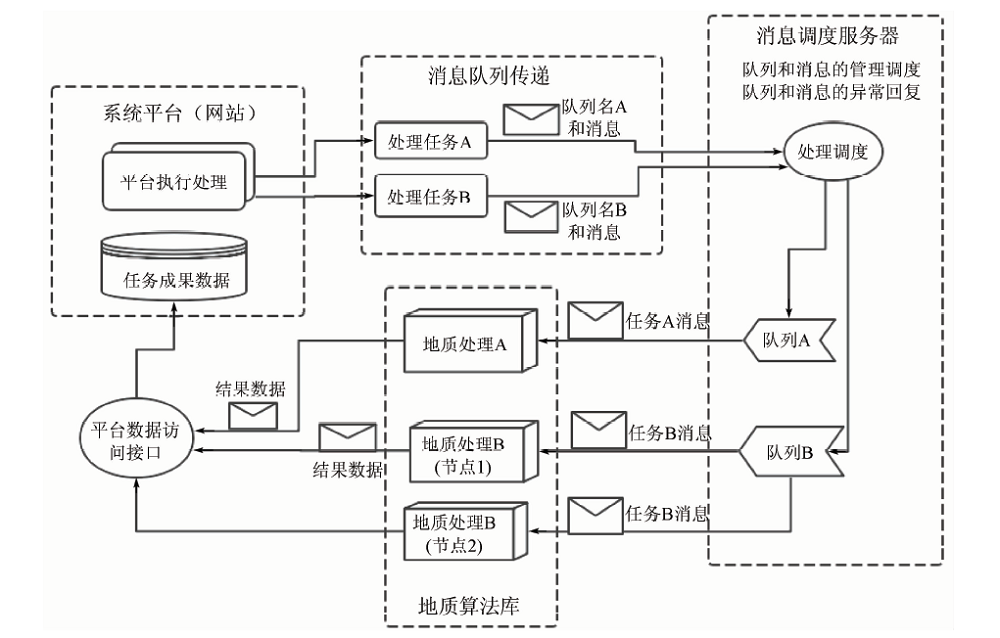
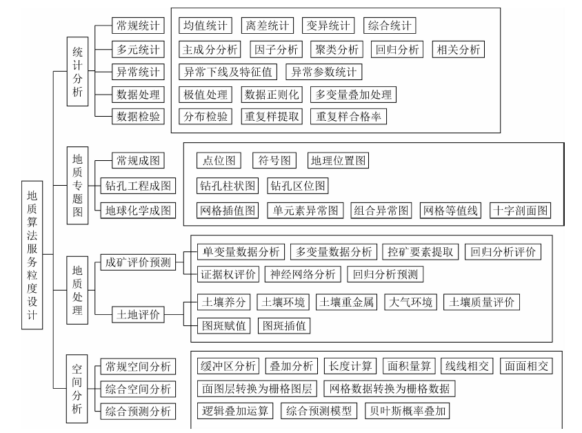
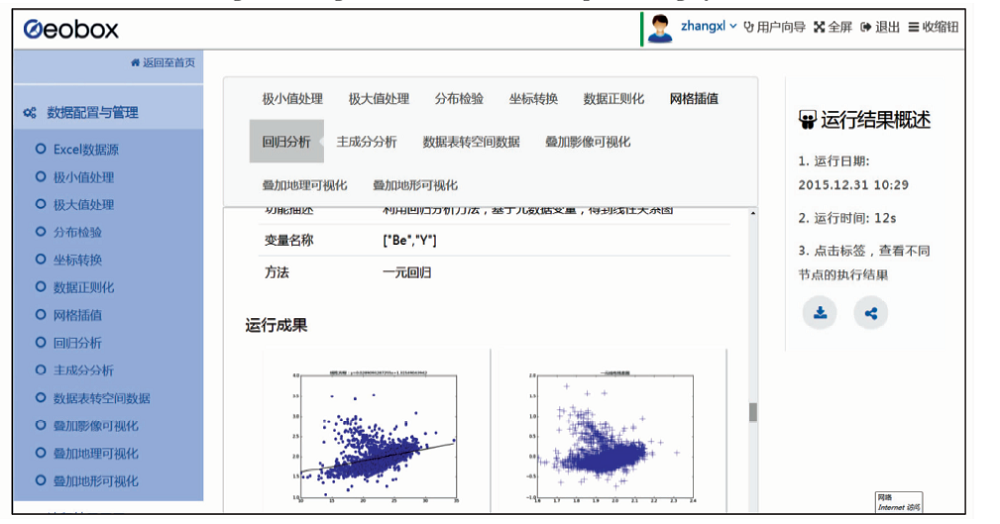
Abstract This paper analyzes the current situation and existing problems of geological data processing services,and proposes a distributed geological service system based on message scheduling mechanism. The architecture is a new attempt of the geological service system,and it preliminarily solves the reuse problem of geological data services and processing services. Firstly,the concept of message mechanism and application model is introduced; secondly, geological processing service application architecture of message scheduling mechanism is designed and the geological algorithm library service package as well as geological data sharing service is realized,and the geological message processing process is described. Lastly,an online processing services flow is demonstrated. Practice has proved that the scheduling mechanism can greatly reuse geological data services and processing services so as to meet the rapid development of Internet application system to save algorithm re-encoding and service production, so it can be widely used in geological data processing services.
|
| Keywords
message queue
geological algorithm library
service reuse
|
|
|
|
Corresponding Authors:
Dunjiang SONG
E-mail: songdj@casipm.ac.cn
|
|
Issue Date: 14 March 2019
|
|
|
| [1] |
Granell C, Díaz L, Gould M . Service-oriented applications for environmental models:Reusable geospatial services[J]. Environmental Modelling and Software, 2010,25(2):182-198.
doi: 10.1016/j.envsoft.2009.08.005
url: https://linkinghub.elsevier.com/retrieve/pii/S1364815209002047
|
| [2] |
Best B D, Halpin P N, Fujioka E , et al. Geospatial web services within a scientific workflow:Predicting marine mammal habitats in a dynamic environment[J]. Ecological Informatics, 2007,2(3):210-223.
doi: 10.1016/j.ecoinf.2007.07.007
url: https://linkinghub.elsevier.com/retrieve/pii/S1574954107000477
|
| [3] |
Feng M, Liu S G, Euliss Jr N H, et al. Prototyping an online wetland ecosystem services model using open model sharing standards[J]. Environmental Modelling and Software, 2011,26(4):458-468.
doi: 10.1016/j.envsoft.2010.10.008
url: https://linkinghub.elsevier.com/retrieve/pii/S1364815210002689
|
| [4] |
Fitch P, Bai Q F. A standards based web service interface for hydrological models[C]// Cairns.18th World IMACS/MODSIM Congress.Australia: 2009.
|
| [5] |
王卷乐, 游松财, 谢传节 , 等. 面向Web的地学数据共享服务平台架构设计[J]. 地球信息科学, 2004,6(4):62-65.
doi: 10.3969/j.issn.1560-8999.2004.04.014
url: http://d.wanfangdata.com.cn/Periodical/dqxxkx200404014
|
| [5] |
Wang J L, You S C, Xie C J , et al. Study on web-oriented geo-data sharing platform system structure[J]. Geo-Information Science, 2004,6(4):62-45.
|
| [6] |
苏国辉, 申延平, 孙记红 , 等. 全球油气地质信息共享系统[J]. 地球信息科学, 2012,14(2):217-222.
doi: 10.3724/SP.J.1047.2012.00217
url: http://www.cqvip.com/QK/86408A/201202/41596587.html
|
| [6] |
Su G H, Shen Y P, Sun J H , et al. The global oil and gas geology database information sharing system based on ArcGIS Serve[J]. Journal Of Geo-Information Science, 2012,14(2):217-222.
|
| [7] |
马维峰, 王晓蕊, 高山 . 基于关系数据库和WebGIS的中国东部地球化学科学数据库[J]. 地球科学-中国地质大学学报, 2008,33(3):423-430.
doi: 10.3321/j.issn:1000-2383.2008.03.019
url: http://www.cnki.com.cn/Article/CJFDTotal-DQKX200803020.htm
|
| [7] |
Ma W F, Wang X R, Gao S . Geochemistry science database system for East China based on relational database and WebGIS[J]. Earth Science—Journal of China University of Geosciences, 2008,33(3):432-430.
|
| [8] |
高振记, 谢华锋, 李志伟 , 等. 油气资源地质调查大数据架构与应用研究[J]. 地理信息世界, 2016,23(1):18-23.
url: http://d.wanfangdata.com.cn/Periodical/dlxxsj201601003
|
| [8] |
Gao Z J, Xie H F, Li Z W , et al. Research on the architecture and application of the big data in oil and gas geological survey[J]. Geomatics World, 2016,23(1):18-23.
|
| [9] |
缪谨励, 屈红刚, 许哲 , 等. 地学大数据技术研究实验平台GeoBDA[J]. 地理信息世界, 2014,21(6):48-52.
doi: 10.3969/j.issn.1672-1586.2014.06.009
url: http://d.wanfangdata.com.cn/Periodical/dlxxsj201406009
|
| [9] |
Miao J L, Qu H G, Xu Z , et al. The experimental platform of technical study of the big data of geoscience:GeoBDA[J]. Geomatics World, 2014,21(6):48-52.
|
| [10] |
谭永杰 . 地质大数据体系建设的总体框架研究[J]. 中国地质调查, 2016,3(3):1-6.
url: http://d.wanfangdata.com.cn/Periodical/zgdzdc201603001
|
| [10] |
TAN Y J . Architecture investigation of the construction of geological big data system[J]. Geological Survey of China, 2016,3(3):1-6.
|
| [11] |
姜作勤, 马智民, 杨东来 , 等. 地质信息服务体系框架研究[J]. 中国地质, 2007,34(1):173-178.
doi: 10.3969/j.issn.1000-3657.2007.01.025
url: http://d.wanfangdata.com.cn/Periodical/zgdizhi200701025
|
| [11] |
Jiang Z Q, Ma Z M, Yang D L , et al. Framework of the geological information service system[J]. Geology in China, 2007,34(1):173-178.
|
| [12] |
刘荣梅, 严光生, 夏庆霖 . 从第34届国际地质大会看地学信息技术发展趋势[J]. 地质通报, 2013,32(4):685-692.
doi: 10.3969/j.issn.1671-2552.2013.04.016
url: http://www.cnki.com.cn/Article/CJFDTotal-ZQYD201304017.htm
|
| [12] |
Liu R M, Yan G S, Xia Q L . The progress and development trend of the geoscience information technology viewed from the abstracts submitted to the 34th IGC held in Brisbane,Australia[J]. Geological Bulletin of China, 2013,32(4):685-692.
|
| [13] |
胡磊, 乐鹏, 龚健雅 , 等. 异步地理信息网络处理服务方法研究[J]. 武汉大学学报(信息科学版), 2016,41(5):679-685.
doi: 10.13203/j.whugis20140413
url: http://www.cqvip.com/QK/92848A/201605/668725137.html
|
| [13] |
Hu L, Le P, Gong J Y , et al. An approach to asynchronous geoprocessing service[J]. Geomatics and Information Science of Wuhan University, 2016,41(5):679-685.
|
| [14] |
刘熙, 胡志勇 . 基于Docker容器的Web集群设计与实现[J]. 电子设计工程, 2016,24(8):117-119.
doi: 10.3969/j.issn.1674-6236.2016.08.033
url: http://d.wanfangdata.com.cn/Periodical/dzsjgc201608033
|
| [14] |
Liu X, Hu Z Y . Design and implementation of Web cluster based on Docker container[J]. Electronic Design Engineering, 2016,24(8):117-119.
|
| [15] |
刘思尧, 李强, 李斌 . 基于Docker技术的容器隔离性研究[J]. 软件, 2015,36(4):110-113.
doi: 10.3969/j.issn.1003-6970.2015.04.025
url: http://d.wanfangdata.com.cn/Periodical/ranj201504025
|
| [15] |
Liu S R, Li Q, Li B . Research on isolation of container based on Docker technology[J]. Software, 2015,36(4):110-113.
|
|
Viewed |
|
|
|
Full text
|
|
|
|
|
Abstract
|
|
|
|
|
Cited |
|
|
|
|
| |
Shared |
|
|
|
|
| |
Discussed |
|
|
|
|
 2019,
Vol. 31
2019,
Vol. 31