|
|
 |
|
|
|
|
Meteorological evaluation system of ecological quality based on open-source GIS technology |
Wenbing XIONG1,2( ), Weihua MO3, Meihua DING3, Junhua WANG3, Jianfei MO3 ), Weihua MO3, Meihua DING3, Junhua WANG3, Jianfei MO3 |
1.Guangxi Laibin Meteorological Bureau, Laibin 546100, China
2.Guangxi Meteorology Science and Technology Service Center, Nanning 530022, China
3.Guangxi Meteorology Disaster Reduction Research Institute, Nanning 530022, China |
|
|
|
|
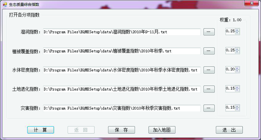
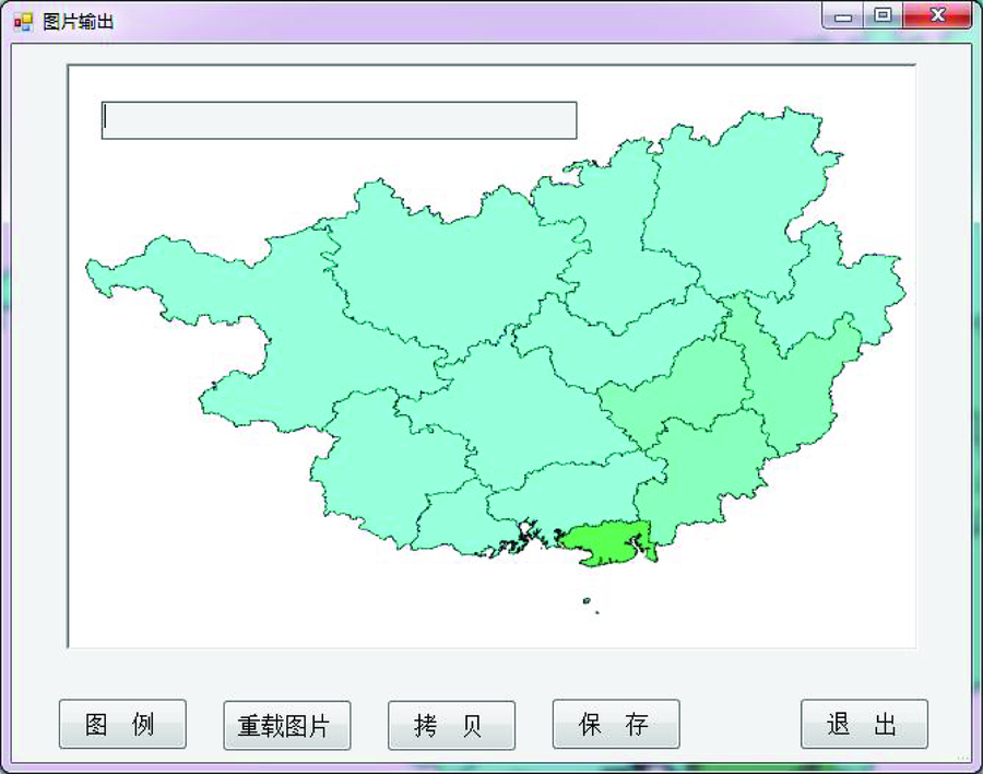
Abstract In order to meet the needs of the application of ecological quality meteorological evaluation technology, the authors designed a service system by using open-source GIS(MapWinGIS) technology in C# develop environment. This system has carried out the analysis and processing of climate data according to the needs of service process. By using MapWinGIS interfaces and class libraries, this platform has achieved the design and development of GIS function. And by self-developed writing class, this platform has the function of the processing of meteorological evaluation data including the MODIS remote sensing data and index calculation, finally obtaining the comprehensive evaluation index of ecological quality by using the GIS map. This system provides a standardized work flow for the ecological quality evaluation.
|
| Keywords
open-source GIS
remote sensing
ecological quality
meteorology
evaluation
system
|
|
|
|
Issue Date: 30 May 2018
|
|
|
| [1] |
王君华, 莫伟华, 陈燕丽 , 等. 基于遥感的广西生态质量气象评价方法研究[J]. 气象科学, 2009,29(6):833-837.
doi: 10.3969/j.issn.1009-0827.2009.06.020
url: http://www.cqvip.com/Main/Detail.aspx?id=32628568
|
| [1] |
Wang J H, Mo W H, Chen Y L , et al. Research on meteorological evaluation of ecological quality in Guangxi based on satellite data[J]. Scientia Meteorologica Sinica, 2009,29(6):833-837.
|
| [2] |
肖建民 . 基于Web与GIS技术的黑龙江省防汛指挥信息服务子系统的设计与实现[D]. 大连:大连理工大学, 2002.
|
| [2] |
Xiao J M . Design and Realization of Flood-Control Information Service Subsystem with Web and GIS in Heilongjiang Province[D]. Dalian: Dalian University of Technology, 2002.
|
| [3] |
戴长雷, 迟宝明, 林岚 , 等. 基于GIS的地下水监测管理信息系统(GMSMIS)分析与设计[J]. 遥感技术与应用, 2005,20(6):625-629.
doi: 10.3969/j.issn.1004-0323.2005.06.017
url: http://d.wanfangdata.com.cn/Periodical/ygjsyyy200506017
|
| [3] |
Dai C L, Chi B M, Lin L , et al. Analysis and design of management information systems of groundwater monitoring based on GIS[J]. Remote Sensing Technology and Application, 2005,20(6):625-629.
|
| [4] |
王学登 . 广东省水资源管理地理信息系统[J].中国农村水利水电, 2005(11):35-36.
|
| [4] |
Wang X D . Guangdong Province water resources management geographic information system[J].China Rural Water and Hydropower, 2005(11):35-36.
|
| [5] |
闾国年, 李峰, 邵进达 .江苏省公路地理信息系统建设规划(上),(下)[J].交通科技, 2000(1):18-22, 2000(2):31-33.
doi: 10.3963/j.issn.1671-7570.2000.01.007
url: http://d.wanfangdata.com.cn/Periodical/sykjxx200001007
|
| [5] |
Lyu G N, Li F, Shao J D. GIS construction plan of highway in Jiangsu Province,GIS construction plan of highway in Jiangsu Province (continued)[J].Transportation Science and Technology, 2000(1):18-22, 2000(2):31-33.
|
| [6] |
石红兵, 魏庆朝, 曾学贵 . 地理信息系统在勘测设计一体化软件开发过程中的应用[J].铁路航测, 2000(2):20-22.
|
| [6] |
Shi H B, Wei Q C, Zeng X G . GIS application in the developing process of survey and design integration software[J].Railway Air Survey, 2000(2):20-22.
|
| [7] |
程玉, 张群, 熊英 . 基于GIS现代物流信息系统的设计[J]. 湖北工业大学学报, 2006,21(4):95-97.
|
| [7] |
Cheng Y, Zhang Q, Xiong Y . A design of logistic information system based on GIS technology[J]. Journal of Hubei University of Technology, 2006,21(4):95-97.
|
| [8] |
黄治勇, 袁正腾, 万军 , 等. 基于GIS长江中游气象水文预报系统的设计[J]. 暴雨灾害, 2007,26(4):316-318.
|
| [8] |
Huang Z Y, Yuan Z T, Wan J , et al. Design of meteorological and hydrological forecasting system based on GIS in the middle reaches of Yangtze River[J]. Torrential Rain and Disasters, 2007,26(4):316-318.
|
| [9] |
李良, 黄生叶 . 基于GIS的山洪灾害预警系统的设计与实现[J]. 科学技术与工程, 2006,6(17):2712-2715.
doi: 10.3969/j.issn.1671-1815.2006.17.022
url: http://d.wanfangdata.com.cn/Periodical/kxjsygc200617022
|
| [9] |
Li L, Huang S Y . Design and implementation of forewarning decision system of mountain torrent base on GIS[J]. Science Technology and Engineering, 2006,6(17):2712-2715.
|
| [10] |
沙莎, 曹芸, 朱晓晨 . 基于GIS的气象灾害评估系统——干旱评估模块的研究[J].科技信息, 2009(23):5-6,13.
doi: 10.3969/j.issn.1001-9960.2009.23.001
url: http://www.cqvip.com/Main/Detail.aspx?id=31334409
|
| [10] |
Sha S, Cao Y, Zhu X C . Meteorological disaster evaluation system based on GIS:Drought assessment module research[J].Science and Technology Information, 2009(23):5-6,13.
|
| [11] |
吴盛洪 . 基于GIS的气象服务监控管理平台的设计与实现[D]. 成都:电子科技大学, 2010.
|
| [11] |
Wu S H . The Design and Implementation of Meteorological Services Monitoring Management Platform based on GIS[D]. Chengdu:University of Electronic Science and Technology of China, 2010.
|
| [12] |
董学士, 毕硕本, 郭文政 . 基于GIS气象查询服务系统的设计和实现[J]. 微计算机信息, 2010,26(7):146-147,137.
|
| [12] |
Dong X S, Bi S B, Guo W Z . The design and implementation of meteorology inquiry service system based on GIS[J]. Control and Automation, 2010,26(7):146-147,137.
|
| [13] |
李轩, 郭安红, 庄立伟 . 基于GIS的主要农作物病虫害气象等级预报系统研究[J]. 国土资源遥感, 2012,24(1):104-109.doi: 10.6046/gtzyyg.2012.01.19.
doi: 10.6046/gtzyyg.2012.01.19
url: http://www.cqvip.com/QK/91397X/201201/41166136.html
|
| [13] |
Li X, Guo A H, Zhuang L W . The main crop diseases and pests meteorology level forecast system based on GIS[J]. Remote Sensing for Land and Resources, 2012,24(1):104-109.doi: 10.6046/gtzyyg.2012.01.19.
|
| [14] |
熊文兵, 孙莹, 王艳兰 , 等. 基于GIS技术和天气雷达的短临预警平台研究[J]. 遥感技术与应用, 2012,27(3):472-478.
url: http://www.cqvip.com/QK/96858A/201203/42213419.html
|
| [14] |
Xiong W B, Sun Y, Wang Y L , et al. The study of early-warning platform based GIS technology and weather Radar[J]. Remote Sensing Technology and Application, 2012,27(3):472-478.
|
| [15] |
施益强, 吴丽娜, 吴陈锋 . 基于GIS的雷达数据三维可视化与预警系统设计与实现[J]. 国土资源遥感, 2013,25(1):171-175.doi: 10.6046/gtzyyg.2013.01.30.
doi: 10.6046/gtzyyg.2013.01.30
url: 年度引用
|
| [15] |
Shi Y Q, Wu L N, Wu C F . Design and implementation of a 3D visualization and early warning system for Radar data based on GIS[J]. Remote Sensing for Land and Resources, 2013,25(1):171-175.doi: 10.6046/gtzyyg.2013.01.30.
|
| [16] |
高大伟, 樊高峰, 胡永亮 , 等. FY-3气象卫星微波水汽三维可视化及其在强天气监测中的应用[J]. 国土资源遥感, 2014,26(1):139-143.doi: 10.6046/gtzyyg.2014.01.24.
doi: 10.6046/gtzyyg.2014.01.24
url: http://www.cqvip.com/QK/91397X/201401/48844665.html
|
| [16] |
Gao D W, Fan G F, Hu Y L , et al. 3D visualization of humidity distribution from FY-3 MWHS and its application to severe weather monitoring[J]. Remote Sensing for Land and Resources, 2014,26(1):139-143.doi: 10.6046/gtzyyg.2014.01.24.
|
|
Viewed |
|
|
|
Full text
|
|
|
|
|
Abstract
|
|
|
|
|
Cited |
|
|
|
|
| |
Shared |
|
|
|
|
| |
Discussed |
|
|
|
|
 2018,
Vol. 30
2018,
Vol. 30