|
|
|

|
|
|
Meteorological data-sharing system of the World Meteorological Organization |
LIU Yufu1( ), BAI Yuqi1,2() ), BAI Yuqi1,2() |
1. Department of Earth System Science, Ministry of Education Ecological Field Station for East Asian Migratory Birds and Their Habitatses, Institute for Global Change Studies, Tsinghua University, Beijing 100084, China
2. Tsinghua Urban Institute, Tsinghua University, Beijing 100084, China |
|
|
|
|
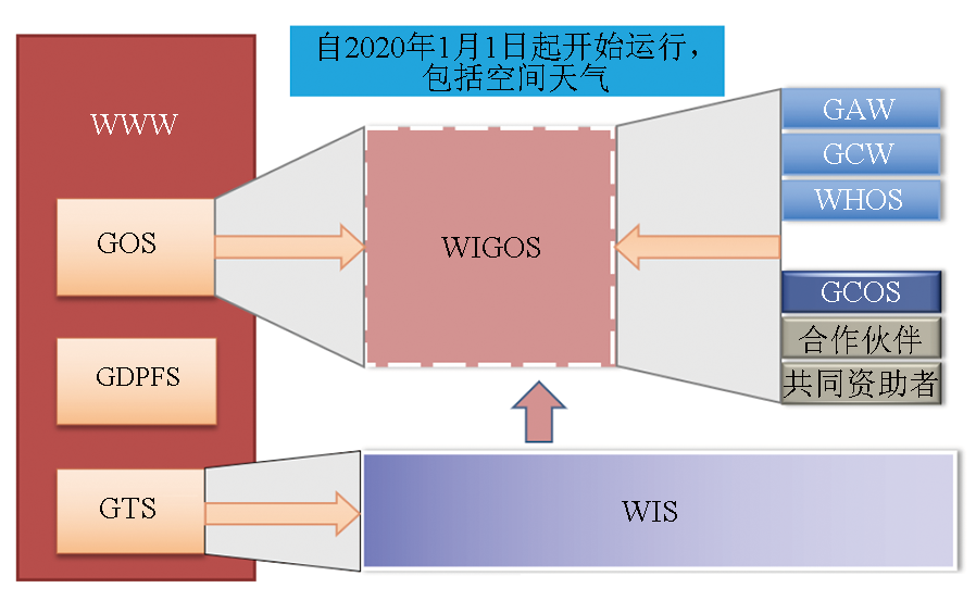
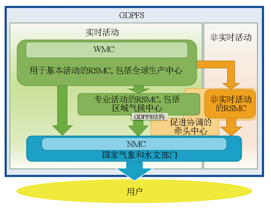
Abstract Through over 70 years of development, the World Meteorological Organization (WMO) has established a global data-sharing network that covers 193 members. This study analyzed the WMO’s meteorological data-sharing system from two aspects: system architecture and composition, and management norms and standards. The meteorological data-sharing system comprises the global observing system (GOS), the global telecommunication system (GTS), the WMO information system (WIS), and the global data-processing and forecasting system (GDPFS). Specifically, the GOS coordinates and schedules observational facilities from land and marine stations, aircraft, environmental satellites, and other platforms. The GTS manages the real-time collection and distribution of meteorological information. The WIS is responsible for discovering, accessing, and managing data and products. The GDPFS provides various climate forecasting data to users. By formulating a unified data policy and establishing this meteorological data-sharing system, the WMO has enabled the global sharing of Earth system science data in multiple fields, such as weather, climate, hydrology, atmospheric composition, cryosphere, and oceans. This study summarizes the achievements of WMO’s meteorological data-sharing system and its alignment with China’s relevant data strategy requirements. It assists in enhancing the understanding of international meteorological data-sharing activities and facilitating the construction of a similar multi-departmental comprehensive Earth observation data-sharing system in China.
|
| Keywords
World Meteorological Organization (WMO)
data-sharing system
global observing system
data policy
|
|
|
|
Issue Date: 31 December 2025
|
|
|
| [1] |
World Meteorological Organization. WMO unified data policy resolution (Res.1)[EB/OL].(2021-04-27)[2022-11-02].https://wmo.int/wmo-unified-data-policy-resolution-res1.
url: https://wmo.int/wmo-unified-data-policy-resolution-res1
|
| [2] |
World Meteorological Organization. WMO unified data policy[M]. Geneva: WMO, 2022.
|
| [3] |
World Meteorological Organization. World weather watch[EB/OL].(2015-09-10)[2022-11-02].https://wmo.int/world-weather-watch.
url: https://wmo.int/world-weather-watch
|
| [4] |
World Meteorological Organization. Global observing system[EB/OL].(2015-09-17)[2022-11-02].https://wmo.int/activities/global-observing-system-gos/global-observing-system-gos.
url: https://wmo.int/activities/global-observing-system-gos/global-observing-system-gos
|
| [5] |
张文建. 世界气象组织全球综合观测系统(WIGOS)空间部分2040年远景发展规解读[J]. 气象科技进展, 2016, 6(1):135-145.
|
| [5] |
Zhang W J. Interpretation of world meteorological organization’s global integrated observing system (WIGOS) space part’s vision development plan in 2040[J]. Advances in Meteorological Science and Technology, 2016, 6(1):135-145.
|
| [6] |
王甫棣, 王鹏. 国际气象通信系统传输模型研究[J]. 计算技术与自动化, 2019, 38(4):156-161.
|
| [6] |
Wang F D, Wang P. Research on transfer model of international meteorological telecommunication system[J]. Computing Technology and Automation, 2019, 38(4):156-161.
|
| [7] |
Love G. The birth of the WMO information system[J]. Bulletin of the World Meteorological Organization, 2006, 55(4):232-238.
|
| [8] |
World Meteorological Organization (WMO). Guide to the WMO integrated global observing system (WMO-No.1165)[M]. Geneva: WMO, 2019.
|
| [9] |
Pecora S, Lins H F. E-monitoring the nature of water[J]. Hydrological Sciences Journal, 2020, 65(5),683-698.
doi: 10.1080/02626667.2020.1724296
url: https://www.tandfonline.com/doi/full/10.1080/02626667.2020.1724296
|
| [10] |
World Meteorological Organization. WMO WIGOS 2040 and data policy[EB/OL].[2023-08-23].https://wmo.int/sites/default/files/2023-10/WMO_WIGOS_2040_AND_DATA_POLICY.pdf.
url: https://wmo.int/sites/default/files/2023-10/WMO_WIGOS_2040_AND_DATA_POLICY.pdf
|
| [11] |
World Meteorological Organization. Annex VIII to the WMO Technical Regulations[M]// Manual on the WMO integrated global observing system (WMO-No.1160)Geneva:WMO, 2021.
|
| [12] |
World Meteorological Organization. Vision for the WMO Integrated Global Observing System in 2040[M]. Geneva: WMO, 2020.
|
| [13] |
World Meteorological Organization. WIGOS Manual.WMO-No.1160[M]. Geneva: WMO, 2021.
|
| [14] |
World Meteorological Organization. Data and product dissemination[EB/OL].https://community.wmo.int/en/activity-areas/wmo-space-programme-wsp/data-and-product-dissemination.
url: https://community.wmo.int/en/activity-areas/wmo-space-programme-wsp/data-and-product-dissemination
|
| [15] |
World Meteorological Organization. WIS overview[EB/OL].[2022-08-23].https://community.wmo.int/en/activity-areas/wis/wis-overview.
url: https://community.wmo.int/en/activity-areas/wis/wis-overview
|
| [16] |
World Meteorological Organization. WIS core components[EB/OL].https://community.wmo.int/en/activity-areas/wmo-information-system-wis/WIS%20Core%20Components.
url: https://community.wmo.int/en/activity-areas/wmo-information-system-wis/WIS%20Core%20Components
|
| [17] |
World Meteorological Organization. Global telecommunication system (GTS)[EB/OL].[2022-08-23].https://community.wmo.int/en/activity-areas/global-telecommunication-system-gts.
url: https://community.wmo.int/en/activity-areas/global-telecommunication-system-gts
|
| [18] |
Asian Disaster Preparedness Center. Critical guidelines on community-based disaster risk management[EB/OL].[2022-08-23].https://www.preventionweb.net/publication/critical-guidelines-community-based-disaster-risk-management.
url: https://www.preventionweb.net/publication/critical-guidelines-community-based-disaster-risk-management
|
| [19] |
World Meteorological Organization. Global data-processing and forecasting system[EB/OL].(2015-10-16)[2022-08-23].https://public.wmo.int/en/programmes/global-data-processing-and-forecasting-system.
url: https://public.wmo.int/en/programmes/global-data-processing-and-forecasting-system
|
| [20] |
World Meteorological Organization. Manual on the global data-processing and forecasting system:Annex IV to the WMO technical regulations[R]. Geneva: WMO,2019:148.
|
| [21] |
World Meteorological Organization. Progress activity report of the extraordinary session of the world meteorological congress (Cg-Ext.(2021))[EB/OL].(2021-10-11)[2023-08-23].https://library.wmo.int/viewer/37353/download?file=Part_II_ProgressActivity_report_CgExt.pdf&type=pdf&navigator=1.
url: https://library.wmo.int/viewer/37353/download?file=Part_II_ProgressActivity_report_CgExt.pdf&type=pdf&navigator=1
|
| [22] |
World Meteorological Organization. General meteorological standards and recommended practices[M]// Basic Documents,2.Technical Regulations. Geneva: WMO, 2019.
|
| [23] |
Organization (WMO) W M,World Meteorological Organization (WMO). Annex VII to the WMO Technical Regulations[M]// Manual on the WMO Information System (WMO-No.1060)Geneva:WMO, 2019.
|
| [24] |
World Meteorological Organization. Annex II to the WMO Technical Regulations:Part A- Alphanumeric Codes[M]// Manual on Codes-International Codes. Geneva: WMO, 2011.
|
| [25] |
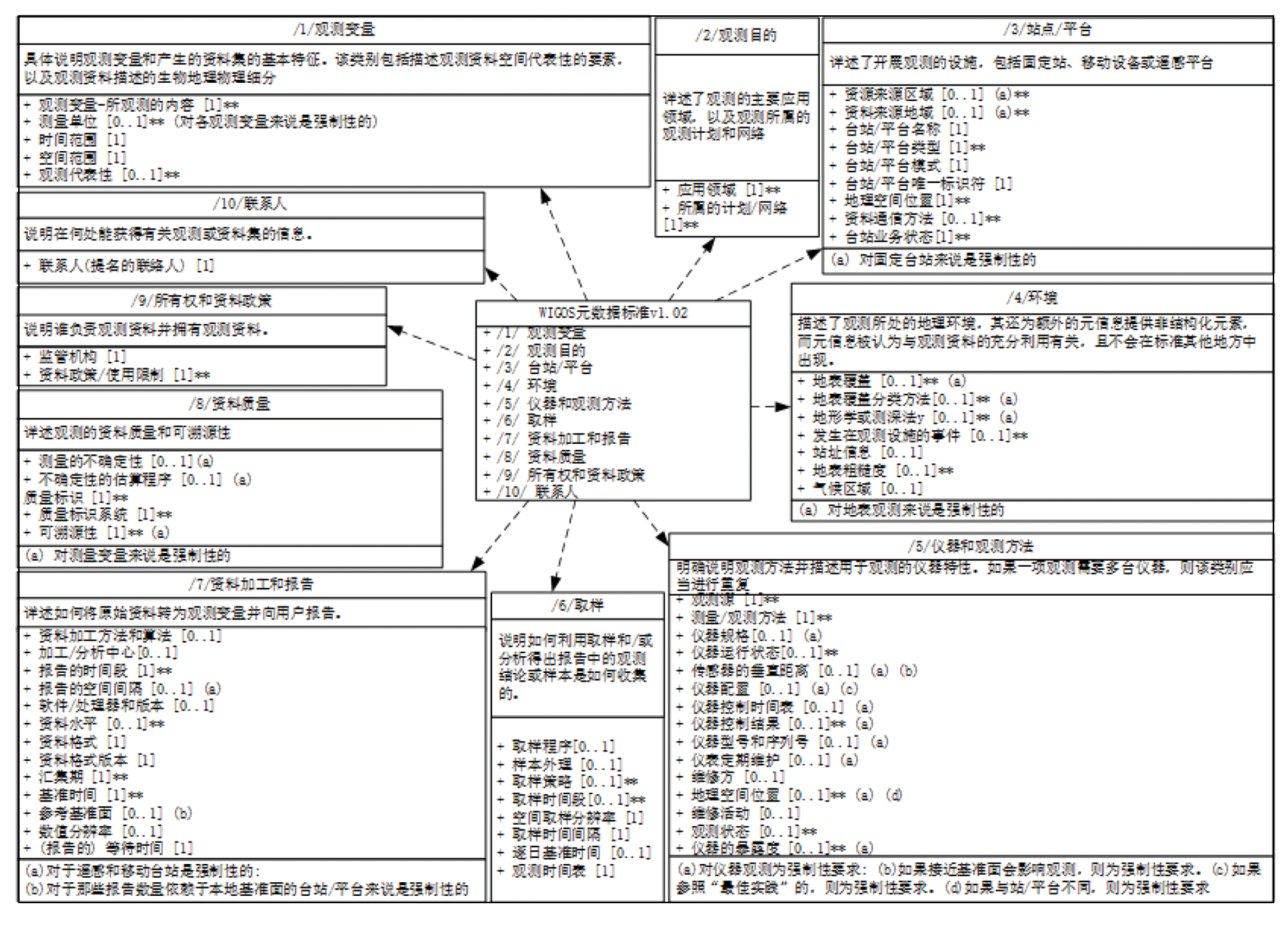
World Meteorological Organization. WIGOS metadata standard[M]. Geneva: WMO, 2019.
|
| [26] |
李湘, 王甫棣, 姜立鹏, 等. WIS的实现技术研究及应用[J]. 气象, 2011, 37(10):1301-1308.
|
| [26] |
Li X, Wang F D, Jiang L P, et al. Research and application of the implementation technologies for WMO information system[J]. Meteorological Monthly, 2011, 37(10):1301-1308.
|
| [27] |
World Meteorological Organization. WIGOS metadata standard:WMO-No.1192[M]. Geneva: WMO, 2021.
|
| [28] |
World Meteorological Organization. Annex III to the WMO technical regulations[M]// Manual on the global telecommunication system. Geneva: WMO, 2015.
|
| [29] |
陈鹏飞, 朱玉洁, 陈正洪. 世界气象组织战略计划动态及其经验启示[J]. 气象科技进展, 2016, 6(5):64-69.
|
| [29] |
Chen P F, Zhu Y J, Chen Z H. World meteorological organization’s strategic plan and its enlightenment[J]. Advances in Meteorological Science and Technology, 2016, 6(5):64-69.
|
|
Viewed |
|
|
|
Full text
|
|
|
|
|
Abstract
|
|
|
|
|
Cited |
|
|
|
|
| |
Shared |
|
|
|
|
| |
Discussed |
|
|
|
|
 2025,
Vol. 37
2025,
Vol. 37