|
|
 |
|

|
|
|
SBAS-InSAR-based long time-series deformation monitoring and landslide hazard identification in the Baihetan reservoir area |
YU Bing1,2,3( ), ZHANG Chunyu1, WANG Jinri1, LIU Guoxiang4, DAI Keren5, MA Deying1 ), ZHANG Chunyu1, WANG Jinri1, LIU Guoxiang4, DAI Keren5, MA Deying1 |
1. School of Civil Engineering and Geomatics, Southwest Petroleum University, Chengdu 610500, China
2. Key Laboratory of Remote Sensing and Mapping Information Technology for Oil and Gas Fields in the Petroleum and Chemical Industry, Chengdu 610500, China
3. Institute of Petroleum and Natural Gas Spatial Information Engineering, Southwest Petroleum University, Chengdu 610500, China
4. Faculty of Geosciences and Environmental Engineering, Southwest Jiaotong University, Chengdu 611756, China
5. School of Earth Science, Chengdu University of Technology, Chengdu 610059, China |
|
|
|
|
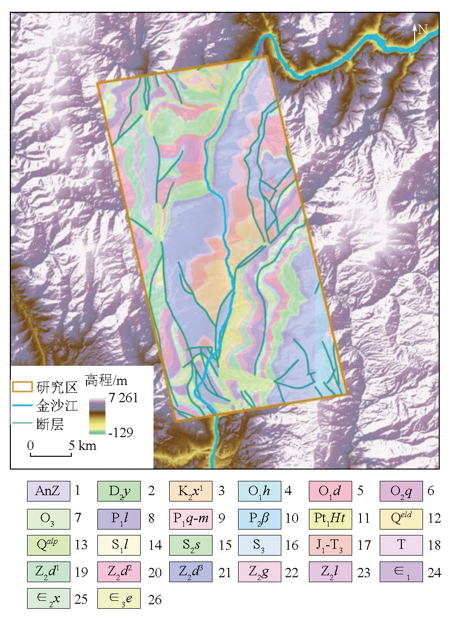
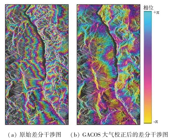
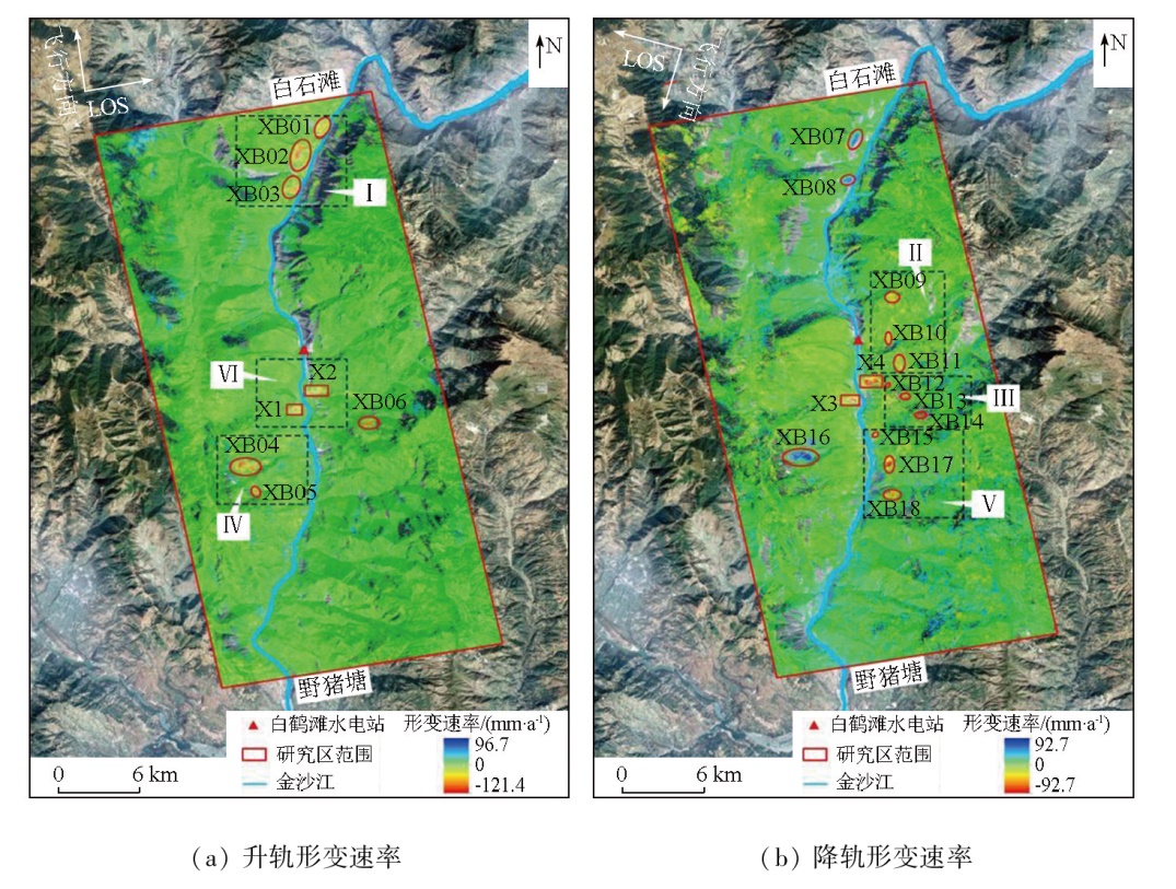
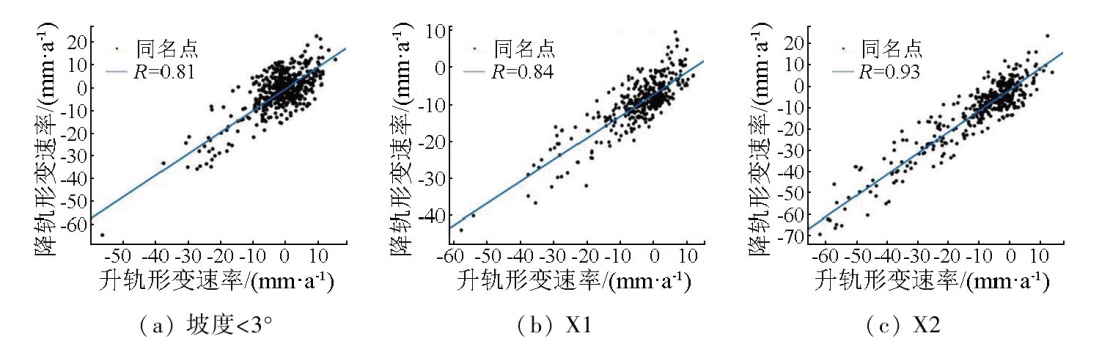
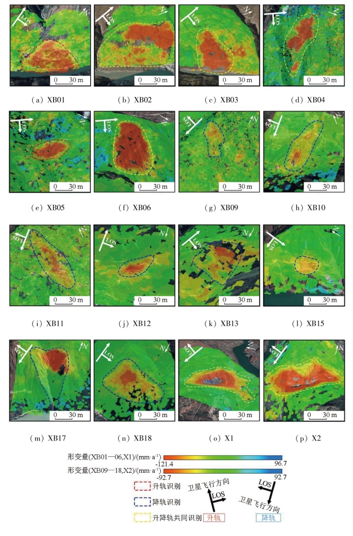
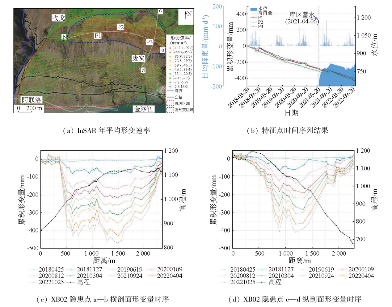
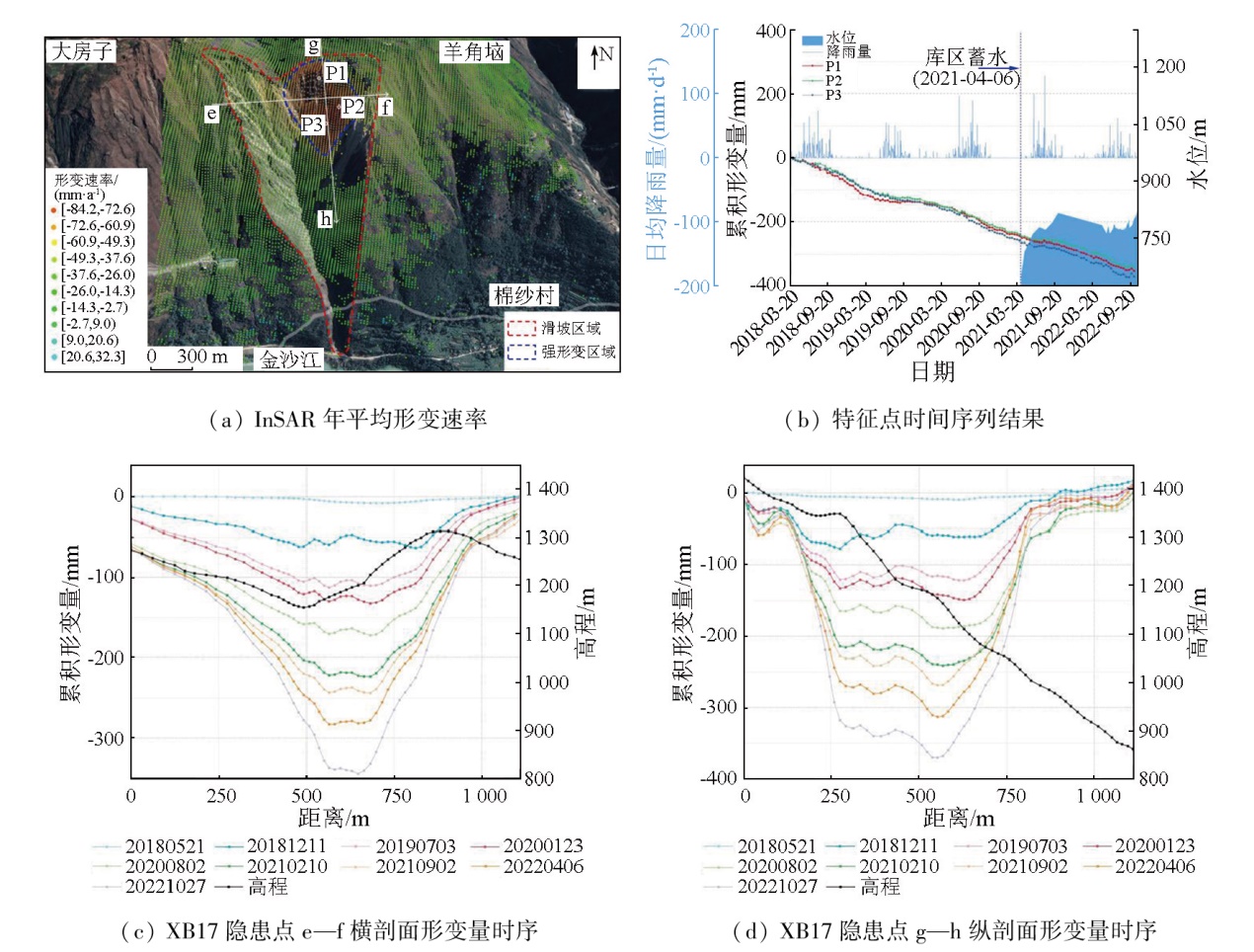
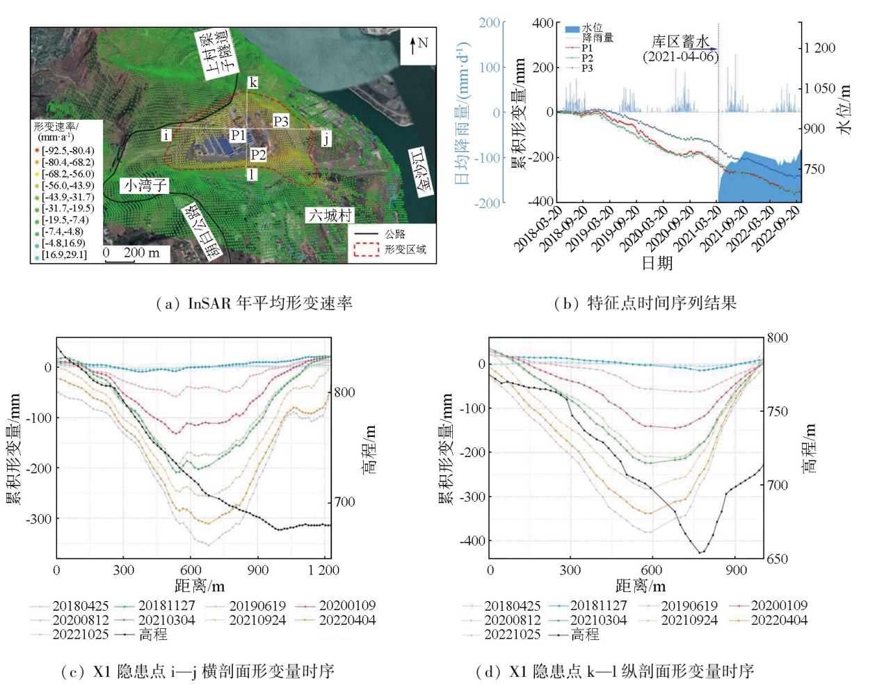
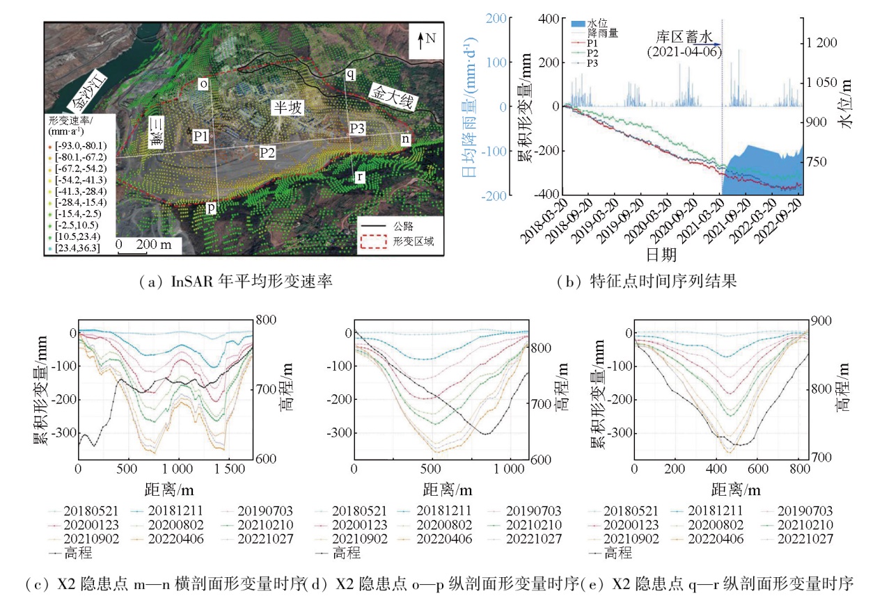
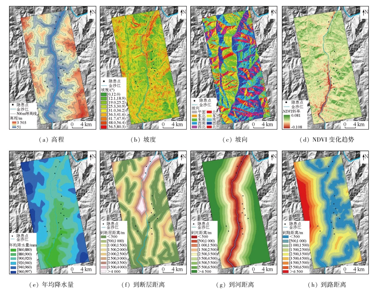
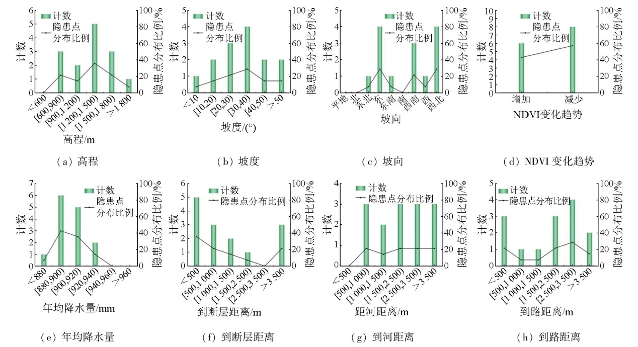
Abstract The reservoir area of the Baihetan hydropower station (also referred to as the Baihetan reservoir area) suffers from frequent geologic hazards. However, there is a lack of monitoring studies on the central area and lower reaches of the hydropower station. Based on the ascending and descending synthetic aperture Radar (SAR) images from the Sentinel-1A satellite, this study performed deformation monitoring and landslide hazard identification in the Baishitan-Yezhutang section of the Baihetan reservoir area using the small baseline subset-interferometric synthetic aperture Radar (SBAS-InSAR) method supported by the generic atmospheric correction online service for InSAR (GACOS). Moreover, this study conducted cross-validation of deformation data from ascending and descending SAR images for low-slope zones. It investigated the spatial distribution of landslide hazards and the movement patterns of typical hazard sites in the study area. Finally, it examined the impacts of factors influencing geologic hazards on the distribution of these hazard sites. The results indicate that the deformation data from ascending and descending SAR images for low-slope zones can be used for cross-validation. Based on the deformation detection results from time-series InSAR and the optical images from Google Earth, 16 landslide hazards were identified, including 14 slow-moving landslides and two significant deformation hazards induced by human engineering activities. Integrating the data of ascending and descending SAR images validated the reliability of deformation results and also enhanced the effectiveness of landslide hazard identification. The analysis of the movement patterns at typical hazard sites indicates a correlation between deformation acceleration and seasonal rainfall. The statistical analysis of factors influencing geologic hazards in the study area reveals that the formation of hazard sites is driven by multiple factors, with varying dominant factors and degrees of influence across different hazards.
|
| Keywords
Baihetan hydropower station
SBAS-InSAR
deformation monitoring
hazard identification
factors influencing geologic hazards
|
|
|
|
Issue Date: 31 December 2025
|
|
|
| [1] |
刘晓杰. 星载雷达遥感广域滑坡早期识别与监测预测关键技术研究[D]. 西安: 长安大学, 2022.
|
| [1] |
Liu X J. Research on key technologies for early identification,monitoring and forecasting of wide-area landslides with spaceborne Radar remote sensing[D]. Xi’an: Chang’an University, 2022.
|
| [2] |
戴可人, 吴明堂, 卓冠晨, 等. 西南山区大型水电工程库岸滑坡InSAR早期识别与监测研究进展[J]. 地球科学与环境学报, 2023, 45(3):559-577.
|
| [2] |
Dai K R, Wu M T, Zhuo G C, et al. Review on InSAR early identification and monitoring of reservoir landslides for large hydropower engineering projects in southwest mountainous area of China[J]. Journal of Earth Sciences and Environment, 2023, 45(3):559-577.
|
| [3] |
康亚, 赵超英, 张勤, 等. InSAR滑坡探测技术研究——以金沙江乌东德水电站段为例[J]. 大地测量与地球动力学, 2018, 38(10):1053-1057.
|
| [3] |
Kang Y, Zhao C Y, Zhang Q, et al. Research on the InSAR technique of landslide detection:A case study of Wudongde hydropower station section,Jinshajiang[J]. Journal of Geodesy and Geodynamics, 2018, 38(10):1053-1057.
|
| [4] |
许强. 对地质灾害隐患早期识别相关问题的认识与思考[J]. 武汉大学学报(信息科学版), 2020, 45(11):1651-1659.
|
| [4] |
Xu Q. Understanding and consideration of related issues in early identification of potential geohazards[J]. Geomatics and Information Science of Wuhan University, 2020, 45(11):1651-1659.
|
| [5] |
许强, 蒲川豪, 赵宽耀, 等. 延安新区地面沉降时空演化特征时序InSAR监测与分析[J]. 武汉大学学报(信息科学版), 2021, 46(7):957-969.
|
| [5] |
Xu Q, Pu C H, Zhao K Y, et al. Time series InSAR monitoring and analysis of spatiotemporal evolution characteristics of land subsidence in Yan’an New District[J]. Geomatics and Information Science of Wuhan University, 2021, 46(7):957-969.
|
| [6] |
Ferretti A, Prati C, Rocca F. Nonlinear subsidence rate estimation using permanent scatterers in differential SAR interferometry[J]. IEEE Transactions on Geoscience and Remote Sensing, 2000, 38(5):2202-2212.
doi: 10.1109/36.868878
url: http://ieeexplore.ieee.org/document/868878/
|
| [7] |
Berardino P, Fornaro G, Lanari R, et al. A new algorithm for surface deformation monitoring based on small baseline differential SAR interferograms[J]. IEEE Transactions on Geoscience and Remote Sensing, 2002, 40(11):2375-2383.
doi: 10.1109/TGRS.2002.803792
url: http://ieeexplore.ieee.org/document/1166596/
|
| [8] |
Ferretti A, Fumagalli A, Novali F, et al. A new algorithm for processing interferometric data-stacks:SqueeSAR[J]. IEEE Transactions on Geoscience and Remote Sensing, 2011, 49(9):3460-3470.
doi: 10.1109/TGRS.2011.2124465
url: http://ieeexplore.ieee.org/document/5765671/
|
| [9] |
戴可人, 沈月, 吴明堂, 等. 联合InSAR与无人机航测的白鹤滩库区蓄水前地灾隐患广域识别[J]. 测绘学报, 2022, 51(10):2069-2082.
doi: 10.11947/j.AGCS.2022.20220305
|
| [9] |
Dai K R, Shen Y, Wu M T, et al. Identification of potential landslides in Baihetan Dam area before the impoundment by combining InSAR and UAV survey[J]. Acta Geodaetica et Cartographica Si-nica, 2022, 51(10):2069-2082.
|
| [10] |
吴明堂, 崔振华, 易小宇, 等. 白鹤滩库区象鼻岭—野猪塘段地质灾害综合遥感识别[J]. 长江科学院院报, 2023, 40(4):155-163.
doi: 10.11988/ckyyb.20211219
|
| [10] |
Wu M T, Cui Z H, Yi X Y, et al. Identification of geohazards in Xiangbiling-Yezhutang section of Baihetan Reservoir area using multi-source remote sensing data[J]. Journal of Changjiang River Scientific Research Institute, 2023, 40(4):155-163.
|
| [11] |
顿佳伟, 冯文凯, 易小宇, 等. 白鹤滩库区蓄水前活动性滑坡InSAR早期识别研究——以葫芦口镇至象鼻岭段为例[J]. 工程地质学报, 2023, 31(2):479-492.
|
| [11] |
Dun J W, Feng W K, Yi X Y, et al. Early insar identification of active landslide before impoundment in Baihetan Reservoir area:A case study of Hulukou Town Xiangbiling section[J]. Journal of Engineering Geology, 2023, 31(2):479-492.
|
| [12] |
Dai K R, Chen C, Shi X L, et al. Dynamic landslides susceptibility evaluation in Baihetan Dam area during extensive impoundment by integrating geological model and InSAR observations[J]. International Journal of Applied Earth Observation and Geoinformation, 2023,116:103157.
|
| [13] |
Liu Y, Yao X, Gu Z K, et al. Research on automatic recognition of active landslides using InSAR deformation under digital morphology:A case study of the Baihetan reservoir,China[J]. Remote Sensing of Environment, 2024,304:114029.
|
| [14] |
Zhu Y R, Qiu H J, Liu Z J, et al. Rainfall and water level fluctuations dominated the landslide deformation at Baihetan Reservoir,China[J]. Journal of Hydrology, 2024,642:131871.
|
| [15] |
朱赛楠, 殷跃平, 王猛, 等. 金沙江结合带高位远程滑坡失稳机理及减灾对策研究——以金沙江色拉滑坡为例[J]. 岩土工程学报, 2021, 43(4):688-697.
|
| [15] |
Zhu S N, Yin Y P, Wang M, et al. Instability mechanism and disaster mitigation measures of long-distance landslide at high location in Jinsha River junction zone:Case study of Sela landslide in Jinsha River,Tibet[J]. Chinese Journal of Geotechnical Engineering, 2021, 43(4):688-697.
|
| [16] |
Yu C, Penna N T, Li Z H. Generation of real-time mode high-resolution water vapor fields from GPS observations[J]. Journal of Geophysical Research:Atmospheres, 2017, 122(3):2008-2025.
doi: 10.1002/jgrd.v122.3
url: https://agupubs.onlinelibrary.wiley.com/toc/21698996/122/3
|
| [17] |
李丹. 基于时序InSAR技术的恩施沙子坝滑坡形变监测与区域易发性评价[D]. 武汉: 华中师范大学, 2021.
|
| [17] |
Li D. Deformation monitoring and regional susceptibility assessment of Shaziba landslide in Enshi based on time series InSAR Technology[D]. Wuhan: Central China Normal University, 2021.
|
| [18] |
Hooper A, Bekaert D, Spaans K, et al. Recent advances in SAR interferometry time series analysis for measuring crustal deformation[J]. Tectonophysics, 2012,514:1-13.
|
| [19] |
Xu B, Li Z W, Wang Q J, et al. A refined strategy for removing composite errors of SAR interferogram[J]. IEEE Geoscience and Remote Sensing Letters, 2014, 11(1):143-147.
doi: 10.1109/LGRS.2013.2250903
url: http://ieeexplore.ieee.org/document/6509971/
|
| [20] |
Wang Q J, Yu W Y, Xu B, et al. Assessing the use of GACOS pro-ducts for SBAS-InSAR deformation monitoring:A case in southern California[J]. Sensors, 2019, 19(18):3894.
doi: 10.3390/s19183894
url: https://www.mdpi.com/1424-8220/19/18/3894
|
| [21] |
刘友奉. 基于DS-InSAR的充填开采区地表沉降监测方法研究[D]. 徐州: 中国矿业大学, 2021.
|
| [21] |
Liu Y F. Study on monitoring method of surface subsidence in filling mining area based on DS-InSAR[D]. Xuzhou: China University of Mining and Technology, 2021.
|
| [22] |
李松林, 许强, 汤明高, 等. 三峡库区滑坡空间发育规律及其关键影响因子[J]. 地球科学, 2020, 45(1):341-354.
|
| [22] |
Li S L, Xu Q, Tang M G, et al. Study on spatial distribution and key influencing factors of landslides in Three Gorges Reservoir area[J]. Earth Science, 2020, 45(1):341-354.
|
| [23] |
方苗, 张金龙, 徐瑱. 基于GIS和Logistic回归模型的兰州市滑坡灾害敏感性区划研究[J]. 遥感技术与应用, 2011, 26(6):845-854.
|
| [23] |
Fang M, Zhang J L, Xu Z. Landslide susceptibility zoning study in Lanzhou City based on GIS and logistic regression model[J]. Remote Sensing Technology and Application, 2011, 26(6):845-854.
|
| [24] |
Collins B D, Stock G M. Rockfall triggering by cyclic thermal stressing of exfoliation fractures[J]. Nature Geoscience, 2016, 9(5):395-400.
doi: 10.1038/NGEO2686
|
| [25] |
李媛茜, 张毅, 苏晓军, 等. 白龙江流域潜在滑坡InSAR识别与发育特征研究[J]. 遥感学报, 2021, 25(2):677-690.
|
| [25] |
Li Y X, Zhang Y, Su X J, et al. Early identification and characteristics of potential landslides in the Bailong River Basin using InSAR technique[J]. National Remote Sensing Bulletin, 2021, 25(2):677-690.
doi: 10.11834/jrs.20210094
url: http://www.ygxb.ac.cn/zh/article/doi/10.11834/jrs.20210094/
|
| [26] |
胡俊. 基于现代测量平差的InSAR三维形变估计理论与方法[D]. 长沙: 中南大学, 2013.
|
| [26] |
Hu J. Theory and method of estimating three-dimensional displacement with InSAR based on the modern surveying adjustment[D]. Changsha: Central South University, 2013.
|
| [27] |
曹中山. 基于易发性和临界降雨阈值的滑坡危险性预警建模研究[D]. 南昌: 南昌大学, 2020.
|
| [27] |
Cao Z S. Study on landslide risk warning modeling based on sensitivity and critical rainfall threshold[D]. Nanchang: Nanchang University, 2020.
|
| [28] |
Huang F M, Chen J W, Liu W P, et al. Regional rainfall-induced landslide hazard warning based on landslide susceptibility mapping and a critical rainfall threshold[J]. Geomorphology, 2022,408:108236.
|
| [29] |
姚鑫, 邓建辉, 刘星洪, 等. 青藏高原泛三江并流区活动性滑坡InSAR初步识别与发育规律分析[J]. 工程科学与技术, 2020, 52(5):16-37.
|
| [29] |
Yao X, Deng J H, Liu X H, et al. Primary recognition of active landslides and development rule analysis for pan three-river-parallel territory of Tibet Plateau[J]. Advanced Engineering Sciences, 2020, 52(5):16-37.
|
| [30] |
程海琴, 陈强, 刘国祥, 等. 短基线InSAR探测龙门山主断裂带两侧震后雨期的滑坡空间分布特征[J]. 测绘学报, 2014, 43(9):931-938.
doi: 10.13485/j.cnki.11-2089.2014.0161
|
| [30] |
Cheng H Q, Chen Q, Liu G X, et al. Post-earthquake landslides distribution along Longmenshan major fault during rainy season with short-baseline InSAR[J]. Acta Geodaetica et Cartographica Sinica, 2014, 43(9):931-938.
|
|
Viewed |
|
|
|
Full text
|
|
|
|
|
Abstract
|
|
|
|
|
Cited |
|
|
|
|
| |
Shared |
|
|
|
|
| |
Discussed |
|
|
|
|
 2025,
Vol. 37
2025,
Vol. 37