|
|
 |
|

|
|
|
Deep forest-based model for detecting changes in remote sensing images |
GE Lihua1,2( ), WANG Peng3,4(), ZHANG Yanqin1, ZHAO Shuanglin5 ), WANG Peng3,4(), ZHANG Yanqin1, ZHAO Shuanglin5 |
1. College of Electronics and Information Engineering, Nanjing University of Aeronautics and Astronautics, Nanjing 211106, China
2. Hebei Key Laboratory of Resource and Environmental Disaster Mechanism and Risk Monitoring, Langfang 065201, China
3. Key Laboratory of Airborne Geophysics and Remote Sensing Geology, Ministry of Natural Resources, Beijing 100083, China
4. Shenzhen Research Institute, Nanjing University of Aeronautics and Astronautics, Shenzhen 518110, China
5. Hunan Institute of Geological Disaster Investigation and Monitoring, Changsha 416099, China |
|
|
|
|
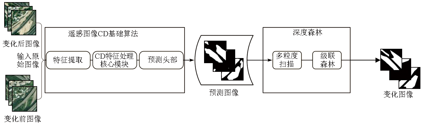
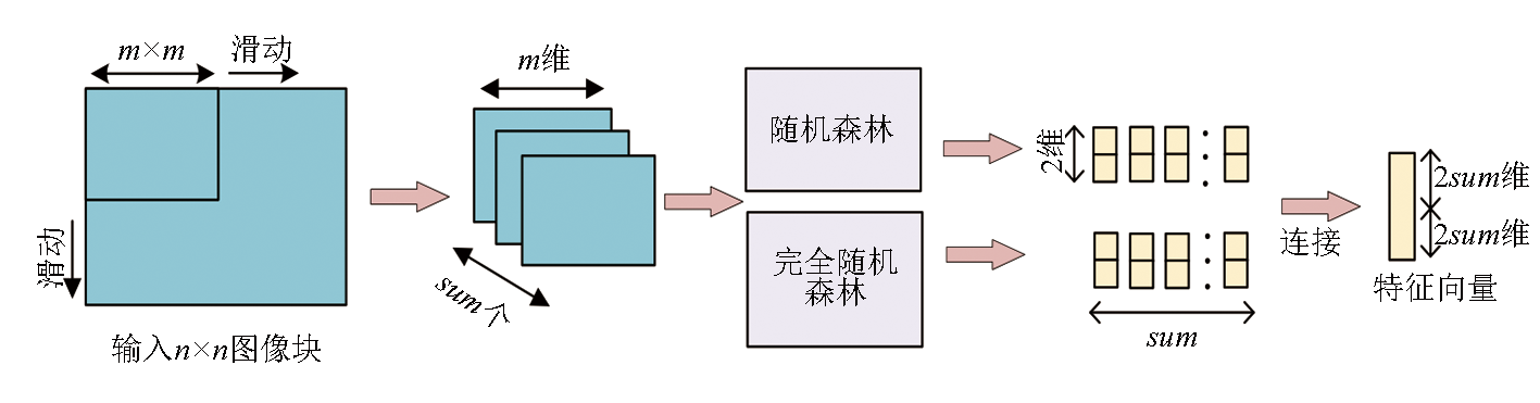
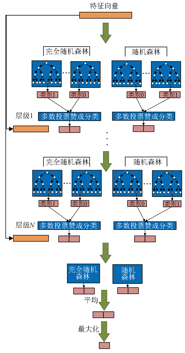
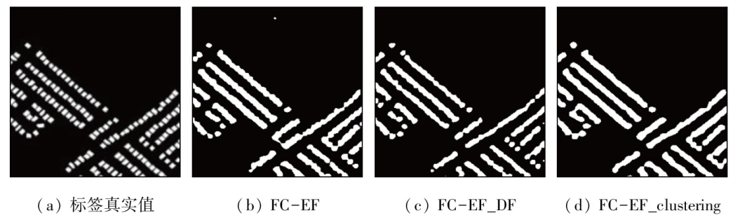
Abstract The deep learning-based models currently available for detecting changes in remote sensing images face several challenges, including limited multi-granularity, poor classification performance of networks, high sensitivity to parameters, and great efforts in parameter adjustment. To address these challenges, this study proposed a deep forest-based model for detecting changes in remote sensing images. Initially, preliminary results were determined using a basic change detection method. Then, the results were optimized using the multi-granularity scanning characteristics and strong data classification of deep forest sub-networks. In this manner, the final change detection results were obtained. Verification experiments conducted on the LEVIR-CD and SYSU-CD datasets using various common change detection models indicated that the proposed deep forest-based model significantly outperformed other models in terms of precision, F1 score, and recall. Additionally, the proposed model exhibited strong adaptability on small datasets, as verified by loss function comparison, small-sample experiments, and ablation studies. This adaptability can reduce the complexity of parameter adjustment and address the issues that other deep learning sub-networks fail to be applicable to medium and small datasets.
|
| Keywords
remote sensing
change detection
deep forest
multi-granularity scanning
cascade forest
|
|
|
|
Issue Date: 31 December 2025
|
|
|
| [1] |
Singh A. Review article digital change detection techniques using remotely-sensed data[J]. International Journal of Remote Sensing, 1989, 10(6):989-1003.
doi: 10.1080/01431168908903939
url: https://www.tandfonline.com/doi/full/10.1080/01431168908903939
|
| [2] |
Huang B, Song H, Cui H, et al. Spatial and spectral image fusion using sparse matrix factorization[J]. IEEE Transactions on Geoscience and Remote Sensing, 2014, 52(3):1693-1704.
doi: 10.1109/TGRS.2013.2253612
url: https://ieeexplore.ieee.org/document/6516902/
|
| [3] |
Wang P, Wang L, Leung H, et al. Super-resolution mapping based on spatial-spectral correlation for spectral imagery[J]. IEEE Transactions on Geoscience and Remote Sensing, 2021, 59(3):2256-2268.
doi: 10.1109/TGRS.36
url: https://ieeexplore.ieee.org/xpl/RecentIssue.jsp?punumber=36
|
| [4] |
Wang Q, Ding X, Tong X, et al. Spatio-temporal spectral unmixing of time-series images[J]. Remote Sensing of Environment, 2021,259:112407.
|
| [5] |
Wang P, Yao H, Li C, et al. Multiresolution analysis based on dual-scale regression for pansharpening[J]. IEEE Transactions on Geoscience and Remote Sensing, 2021,60:5406319.
|
| [6] |
Marin C, Bovolo F, Bruzzone L. Building change detection in multitemporal very high resolution SAR images[J]. IEEE Transactions on Geoscience and Remote Sensing, 2015, 53(5):2664-2682.
doi: 10.1109/TGRS.2014.2363548
url: http://ieeexplore.ieee.org/document/6948368/
|
| [7] |
Huang X, Zhang L, Zhu T. Building change detection from multitemporal high-resolution remotely sensed images based on a morphological building index[J]. IEEE Journal of Selected Topics in Applied Earth Observations and Remote Sensing, 2014, 7(1):105-115.
doi: 10.1109/JSTARS.4609443
url: https://ieeexplore.ieee.org/xpl/RecentIssue.jsp?punumber=4609443
|
| [8] |
Mahdavi S, Salehi B, Huang W, et al. A PolSAR change detection index based on neighborhood information for flood mapping[J]. Remote Sensing, 2019, 11(16):1854.
doi: 10.3390/rs11161854
url: https://www.mdpi.com/2072-4292/11/16/1854
|
| [9] |
Huang B, Song H. Spatiotemporal reflectance fusion via sparse representation[J]. IEEE Transactions on Geoscience and Remote Sensing, 2012, 50(10):3707-3716.
doi: 10.1109/TGRS.2012.2186638
url: http://ieeexplore.ieee.org/document/6169983/
|
| [10] |
He D, Zhong Y, Wang X, et al. Deep convolutional neural network framework for subpixel mapping[J]. IEEE Transactions on Geoscience and Remote Sensing, 2021, 59(11):9518-9539.
doi: 10.1109/TGRS.2020.3032475
url: https://ieeexplore.ieee.org/document/9258409/
|
| [11] |
Gong M, Zhao J, Liu J, et al. Change detection in synthetic aperture Radar images based on deep neural networks[J]. IEEE Transactions on Neural Networks and Learning Systems, 2016, 27(1):125-138.
doi: 10.1109/TNNLS.2015.2435783
pmid: 26068879
|
| [12] |
史文中, 张鹏林, 吕志勇, 等. 地理国情综合指数及其计算模型研究[J]. 测绘地理信息, 2016, 41(1):1-6.
|
| [12] |
Shi W Z, Zhang P L, Lyu Z Y, et al. Composite index and calculation model for national geographical state[J]. Journal of Geoma-tics, 2016, 41(1):1-6.
|
| [13] |
李德仁, 眭海刚, 单杰. 论地理国情监测的技术支撑[J]. 武汉大学学报(信息科学版), 2012, 37(5):505-512,502.
|
| [13] |
Li D R, Sui H G, Shan J. Discussion on key technologies of geographic national conditions monitoring[J]. Geomatics and Information Science of Wuhan University, 2012, 37(5):505-512,502.
|
| [14] |
Chen C F, Son N T, Chang N B, et al. Multi-decadal mangrove forest change detection and prediction in Honduras,Central America,with Landsat imagery and a Markov chain model[J]. Remote Sensing, 2013, 5(12):6408-6426.
doi: 10.3390/rs5126408
url: https://www.mdpi.com/2072-4292/5/12/6408
|
| [15] |
Mei S, Li X, Liu X, et al. Hyperspectral image classification using attention-based bidirectional long short-term memory network[J]. IEEE Transactions on Geoscience and Remote Sensing, 2021,60:5509612.
|
| [16] |
Adão T, Hruška J, Pádua L, et al. Hyperspectral imaging:A review on UAV-based sensors,data processing and applications for agriculture and forestry[J]. Remote Sensing, 2017, 9(11):1110.
doi: 10.3390/rs9111110
url: https://www.mdpi.com/2072-4292/9/11/1110
|
| [17] |
李淑坤, 李培军, 程涛. 加入多时相纹理的遥感变化检测[J]. 国土资源遥感, 2009, 21(3):35-40.doi:10.6046/gtzyyg.2009.03.07.
|
| [17] |
Li S K, Li P J, Cheng T. Remote sensing change detection by inclusion of multitemporal texture[J]. Remote Sensing for Land and Resources, 2009, 21(3):35-40.doi:10.6046/gtzyyg.2009.03.07.
|
| [18] |
Sivic, Zisserman. Video Google:A text retrieval approach to object matching in videos[C]// Proceedings Ninth IEEE International Conference on Computer Vision. October 13-16,2003, Nice,France.IEEE, 2003:1470-1477.
|
| [19] |
Malila W. Change vector analysis:An approach for detecting forest changes with Landsat[C]// LARS symposia.1980:385.
|
| [20] |
邸凤萍, 朱重光, 丁玲. 方向矢量法在城市土地利用变化检测中的应用[J]. 计算机工程, 2008, 34(2):253-254.
doi: 10.3969/j.issn.1000-3428.2008.02.085
|
| [20] |
Di F P, Zhu C G, Ding L. Application of direction-vector analysis in change detection of urban land-use[J]. Computer Engineering, 2008, 34(2):253-254.
doi: 10.1007/s00366-017-0537-7
url: http://link.springer.com/10.1007/s00366-017-0537-7
|
| [21] |
Fang S, Li K, Shao J, et al. SNUNet-CD:A densely connected Siamese network for change detection of VHR images[J]. IEEE Geoscience and Remote Sensing Letters, 2021,19:8007805.
|
| [22] |
Li K, Li Z, Fang S. Siamese NestedUNet networks for change detection of high resolution satellite image[C]// 2020 International Conference on Control,Robotics and Intelligent System.Xiamen China. ACM, 2020:42-48.
|
| [23] |
Daudt R C, Le Saux B, Boulch A. Fully convolutional Siamese networks for change detection[C]// 2018 25th IEEE International Conference on Image Processing (ICIP).October 7-10,2018,Athens,Greece.IEEE, 2018:4063-4067.
|
| [24] |
Daudt R C. Convolutional neural networks for change analysis in earth observation images with noisy labels and domain shifts[D]. Paris: Institut Polytechnique de Paris, 2020.
|
| [25] |
Liu Y, Pang C, Zhan Z, et al. Building change detection for remote sensing images using a dual-task constrained deep Siamese convolutional network model[J]. IEEE Geoscience and Remote Sensing Letters, 2021, 18(5):811-815.
doi: 10.1109/LGRS.2020.2988032
|
| [26] |
Chen H, Shi Z. A spatial-temporal attention-based method and a new dataset for remote sensing image change detection[J]. Remote Sensing, 2020, 12(10):1662.
doi: 10.3390/rs12101662
url: https://www.mdpi.com/2072-4292/12/10/1662
|
| [27] |
Fang H, Du P, Wang X. A novel unsupervised binary change detection method for VHR optical remote sensing imagery over urban areas[J]. International Journal of Applied Earth Observation and Geoinformation, 2022,108:102749.
|
| [28] |
杜俊翰, 赖健, 王雪, 等. 基于多尺度注意力特征与孪生判别的遥感影像变化检测及其抗噪性研究[J]. 数据采集与处理, 2022, 37(1):35-48.
|
| [28] |
Du J H, Lai J, Wang X, et al. Change detection of remote sensing image based on Siamese multi-scale attention network and its anti-noise ability research[J]. Journal of Data Acquisition and Processing, 2022, 37(1):35-48.
|
| [29] |
Wang D, Chen X, Guo N, et al. STCD:Efficient Siamese transformers-based change detection method for remote sensing images[J]. Geo-Spatial Information Science, 2024, 27(4):1192-1211.
doi: 10.1080/10095020.2022.2157762
url: https://www.tandfonline.com/doi/full/10.1080/10095020.2022.2157762
|
| [30] |
Zhou Z H, Feng J. Deep forest[J]. National science review, 2019, 6(1):74-86.
doi: 10.1093/nsr/nwy108
url: https://academic.oup.com/nsr/article/6/1/74/5123737
|
| [31] |
杨惠. 基于深度森林的SAR图像变化检测技术研究[D]. 西安: 西安电子科技大学, 2019.
|
| [31] |
Yang H. Research on SAR image change detection technology based on deep forest[D]. Xi’an: Xidian University, 2019.
|
| [32] |
李恒. 基于遥感影像的森林变化检测方法研究[D]. 长沙: 中南林业科技大学, 2022.
|
| [32] |
Li H. Research on forest change detection method based on remote sensing image[D]. Changsha: Central South University of Forestry and Technology, 2022.
|
| [33] |
Breiman L. Random forests[J]. Machine Learning, 2001,45:5-32.
|
|
Viewed |
|
|
|
Full text
|
|
|
|
|
Abstract
|
|
|
|
|
Cited |
|
|
|
|
| |
Shared |
|
|
|
|
| |
Discussed |
|
|
|
|
 2025,
Vol. 37
2025,
Vol. 37