|
|
|
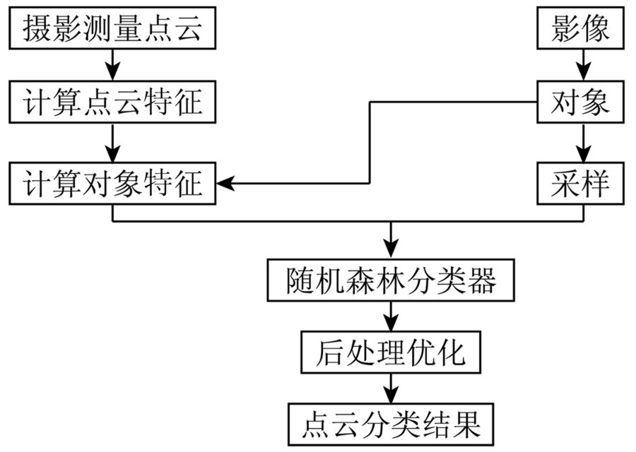
Abstract With the development of image dense matching method, point clouds can be obtained from multi-view oblique aerial images, whose accuracy and density can be comparable with LiDAR point clouds. However, the currently derived colored point clouds lack classification information. In view of such a situation, this paper proposes an object-based classification method for oblique photogrammetric point clouds. The first step of this method is to calculate features of each point. Then, SLIC algorithm is used to divide the corresponding image into super-pixels. After that, point clouds are clustered into super-voxels as objects according to the relationship between point clouds and images, and features of each object are calculated afterwards. Random forests algorithm is used to classify these super-voxels. Finally, contextual information is adopted to optimize the initial classification results. Two sets of data were employed for evaluating the proposed method, and the overall accuracy could reach up to 91.2% and 88.1% respectively, which improves the precision by 2.3% and 8.2% compared with the point-based classification.
|
| Keywords
point clouds classification
features of point clouds
oblique image
object-oriented
random forests
|
|
|
|
Issue Date: 30 May 2018
|
|
|
| [1] |
Hirschmüller H.Accurate and efficient stereo processing by semi-global matching and mutual information[C]//Proceedings of 2005 IEEE Computer Society Conference on Computer Vision and Pattern Recognition.San Diego,USA:IEEE, 2005: 807-814.
|
| [2] |
Hirschmüller H . Stereo processing by semiglobal matching and mutual information[J]. IEEE Transactions on Pattern Analysis and Machine Intelligence, 2008,30(2):328-341.
doi: 10.1109/TPAMI.2007.1166
url: http://ieeexplore.ieee.org/document/4359315/
|
| [3] |
Wehr A, Lohr U . Airborne laser scanning:An introduction and overview[J]. ISPRS Journal of Photogrammetry and Remote Sensing, 1999,54(2/3):68-82.
doi: 10.1016/S0924-2716(99)00011-8
url: http://linkinghub.elsevier.com/retrieve/pii/S0924271699000118
|
| [4] |
Xu S, Vosselman G, Elberink S O . Multiple-entity based classification of airborne laser scanning data in urban areas[J]. ISPRS Journal of Photogrammetry and Remote Sensing, 2014,88:1-15.
doi: 10.1016/j.isprsjprs.2013.11.008
url: http://linkinghub.elsevier.com/retrieve/pii/S0924271613002700
|
| [5] |
Gerke M, Xiao J . Fusion of airborne laser scanning point clouds and images for supervised and unsupervised scene classification[J]. ISPRS Journal of Photogrammetry and Remote Sensing, 2014,87:78-92.
doi: 10.1016/j.isprsjprs.2013.10.011
url: http://linkinghub.elsevier.com/retrieve/pii/S0924271613002335
|
| [6] |
Guan H Y, Li J, Chapman M , et al. Integration of orthoimagery and Lidar data for object-based urban thematic mapping using random forests[J]. International Journal of Remote Sensing, 2013,34(14):5166-5186.
doi: 10.1080/01431161.2013.788261
url: http://www.tandfonline.com/doi/abs/10.1080/01431161.2013.788261
|
| [7] |
徐宏根, 王建超, 郑雄伟 , 等. 面向对象的植被与建筑物重叠区域的点云分类方法[J]. 国土资源遥感, 2012,24(2):23-27.doi: 10.6046/gtzyyg.2012.02.05.
doi: 10.6046/gtzyyg.2012.02.05
url: http://d.wanfangdata.com.cn/Periodical/gtzyyg201202005
|
| [7] |
Xu H G, Wang J C, Zheng X W , et al. Object-based point clouds classification of the vegetation and building overlapped area[J]. Remote Sensing for Land and Resources, 2012,24(2):23-27.doi: 10.6046/gtzyyg.2012.02.05.
|
| [8] |
Rothermel M, Haala N. Potential of dense matching for the generation of high quality digital elevation models [C]//International Archives of the Photogrammetry,Remote Sensing and Spatial Information Sciences.Hannover,Germany:ISPRS, 2011: 331-343.
|
| [9] |
Debella-Gilo M, Bjørkelo K, Breidenbach J , et al.Object-based analysis of aerial photogrammetric point cloud and spectral data for land cover mapping[C]//Proceedings of 2013 International Archives of the Photogrammetry,Remote Sensing and Spatial Information Sciences,Volume XL-1/W1.Hannover,Germany:ISPRS, 2013: 63-67.
|
| [10] |
Xiao J, Gerke M, Vosselman G . Building extraction from oblique airborne imagery based on robust façade detection[J]. ISPRS Journal of Photogrammetry and Remote Sensing, 2012,68:56-68.
doi: 10.1016/j.isprsjprs.2011.12.006
url: http://linkinghub.elsevier.com/retrieve/pii/S0924271611001602
|
| [11] |
Rau J Y, Jhan J P, Hsu Y C . Analysis of oblique aerial images for land cover and point cloud classification in an urban environment[J]. IEEE Transactions on Geoscience and Remote Sensing, 2015,53(3):1304-1319.
doi: 10.1109/TGRS.2014.2337658
url: http://ieeexplore.ieee.org/document/6870455/
|
| [12] |
Gerke M, Xiao J .Supervised and unsupervised MRF based 3D scene classification in multiple view airborne oblique images[C]//Proceedings of 2013 ISPRS Annals of the Photogrammetry,Remote Sensing and Spatial Information Sciences.Antalya,Turkey:ISPRS, 2013: 25-30.
|
| [13] |
孙杰, 赖祖龙 . 利用随机森林的城区机载LiDAR数据特征选择与分类[J]. 武汉大学学报(信息科学版), 2014,39(11):1310-1313.
|
| [13] |
Sun J, Lai Z L . Airborne LiDAR feature selection for urban classification using random forests[J]. Geomatics and Information Science of Wuhan University, 2014,39(11):1310-1313.
|
| [14] |
Hu H, Ding Y L, Zhu Q , et al. An adaptive surface filter for airborne laser scanning point clouds by means of regularization and bending energy[J]. ISPRS Journal of Photogrammetry and Remote Sensing, 2014,92:98-111.
doi: 10.1016/j.isprsjprs.2014.02.014
url: http://linkinghub.elsevier.com/retrieve/pii/S0924271614000525
|
| [15] |
Rothermel M, Wenzel K, Fritsch D , et al.SURE:Photogrammetric surface reconstruction from imagery[C]//Proceedings of 2012 LC3D Workshop.Berlin,Germany:[s.n], 2012: 1-9.
|
| [16] |
Achanta R, Shaji A, Smith K , et al. SLIC superpixels compared to state-of-the-art superpixel methods[J]. IEEE Transactions on Pattern Analysis and Machine Intelligence, 2012,34(11):2274-2282.
doi: 10.1109/TPAMI.2012.120
pmid: 22641706
url: http://ieeexplore.ieee.org/document/6205760/
|
| [17] |
Breiman L . Random forests[J]. Machine Learning, 2001,45(1):5-32.
doi: 10.1023/A:1010933404324
url: http://link.springer.com/10.1023/A:1010933404324
|
| [18] |
Guo L, Chehata N, Mallet C , et al. Relevance of airborne Lidar and multispectral image data for urban scene classification using random forests[J]. ISPRS Journal of Photogrammetry and remote Sensing, 2011,66(1):56-66.
doi: 10.1016/j.isprsjprs.2010.08.007
url: http://linkinghub.elsevier.com/retrieve/pii/S0924271610000705
|
|
Viewed |
|
|
|
Full text
|
|
|
|
|
Abstract
|
|
|
|
|
Cited |
|
|
|
|
| |
Shared |
|
|
|
|
| |
Discussed |
|
|
|
|
 2018,
Vol. 30
2018,
Vol. 30
 ), Zhengrong ZOU, Yunsheng ZHANG, Shouji DU, Te ZHENG