|
|
 |
|

|
|
|
Object-oriented rapid forest change detection based on distribution function |
Linyan FENG1,2, Bingxiang TAN1,2( ), Xiaohui WANG1,2, Xinyun CHEN3, Weisheng ZENG3, Zhao QI1,2 ), Xiaohui WANG1,2, Xinyun CHEN3, Weisheng ZENG3, Zhao QI1,2 |
1. Research Institute of Forest Resources Information Techniques, Chinese Academy of Forestry, Beijing 100091, China
2. Key Laboratory of Forestry Remote Sensing and Information System, NFGA, Beijing 100091, China
3. Academy of Forest and Grassland Inventory and Planning, Beijing 100714, China |
|
|
|
|
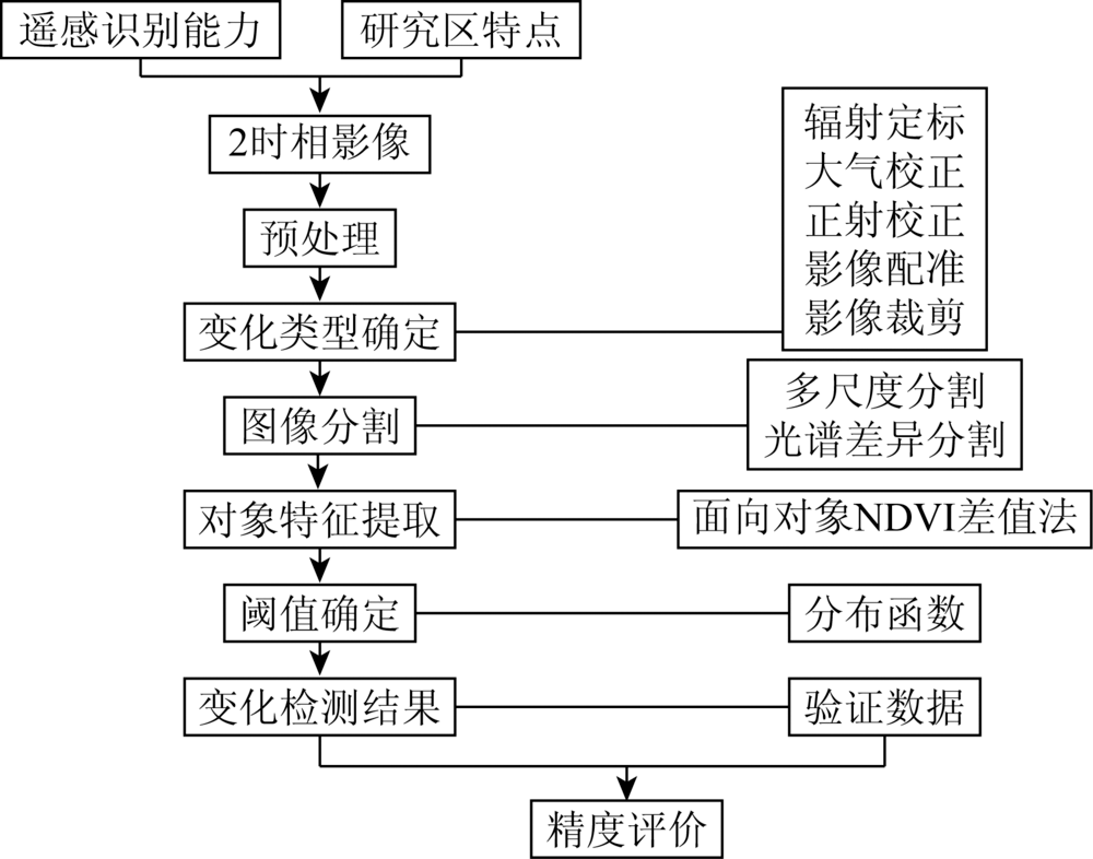
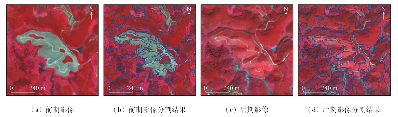
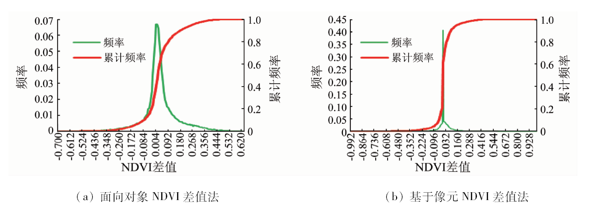
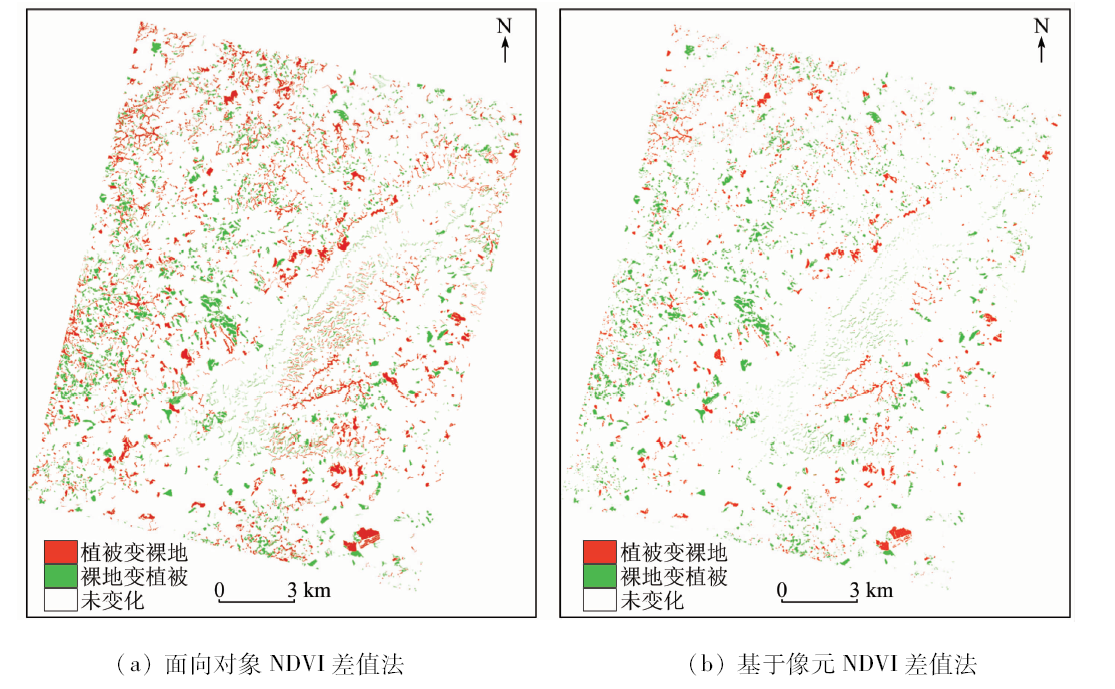
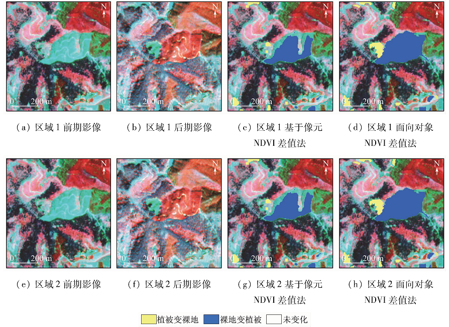
Abstract Plantation in southern China is growing rapidly, and rotation cutting period is short. To explore the forest change detection method used to update the forest resource database effectively and to monitor the dynamic changes in forest harvesting and renewal in a short period, the authors chose the plantation area of Shangsi County in Guangxi as the study area, where the plantation area changes frequently and rapidly and the change patterns are numerous and small. The GF-2 remote sensing images of two phases were used as data sources. Multi-scale segmentation and spectral difference segmentation were used to segment the two-phase images. The change areas and change types were extracted from the NDVI difference of the objects and the threshold value was determined based on the distribution function, so as to realize the rapid detection of forest change. In addition, the same method was adopted for pixel-based processing in comparison with object-oriented NDVI difference method. The results show that the overall accuracy of the object-oriented NDVI difference method is 87.12%, and the Kappa coefficient is 0.81. The accuracy and extraction effect are better than those of the pixel-based NDVI difference method, indicating that the object-oriented NDVI difference method can better depict the shape and boundary of the change spots and can also more accurately detect the small change area. This method can be adapted to detect the changing characteristics of plantation in south China and can also be used to update the forest resource database for the purpose of rapid change detection.
|
| Keywords
GF-2
change detection
NDVI
object-oriented
distribution function
|
|
|
|
Corresponding Authors:
Bingxiang TAN
E-mail: tan@ifrit.ac.cn
|
|
Issue Date: 18 June 2020
|
|
|
| [1] |
赵宪文, 李崇贵, 斯林, 等. 基于信息技术的森林资源调查新体系[J]. 北京林业大学学报, 2002,24(5/6):147-155.
|
| [1] |
Zhao X W, Li C G, Si L, et al. Building a new system of forest resources inventory by information technology[J]. Journal of Beijing University, 2002,24(5/6):147-155.
|
| [2] |
Ban Y, Yousif O. Change techniques:A review[M]. Multitemporal Remote Sensing.Stockholm:Springer, 2016.
|
| [3] |
陈雅如, 肖文发, 冯源, 等. 三峡库区1992—2012年森林景观格局演变研究[J]. 林业科学研究, 2017,30(4):542-550.
|
| [3] |
Chen Y R, Xiao W F, Feng Y, et al. Evolution of forest landscape pattern in the There Gorges reservoir area during 1992—2012[J]. Forest Research, 2017,30(4):542-550.
|
| [4] |
沈文娟, 李明诗, 黄成全. 长时间序列多源遥感数据的森林干扰监测算法研究进展[J]. 遥感学报, 2018,22(6):1005-1022.
|
| [4] |
Shen W J, Li M S, Huang C Q. Review of remote sensing algorithms for monitoring forest disturbance from time series and multi-source data fusion[J]. Journal of Remote Sensing, 2018,22(6):1005-1022.
|
| [5] |
Ian H, Robert C, Mark F. An evaluation of forest health insect and disease survey data and satellite-based remote sensing forest change detection methods:Case studies in the United States[J]. Remote Sensing, 2018,10(8):1184-1192.
|
| [6] |
Kim D H, Sexton J O, Noojipady P, et al. Global, Landsat-based forest-cover change from 1990 to 2000[J]. Remote Sensing of Environment, 2014,155:178-193.
doi: 10.1016/j.rse.2014.08.017
url: https://linkinghub.elsevier.com/retrieve/pii/S0034425714003149
|
| [7] |
刁娇娇, 龚鑫烨, 李明诗. 利用综合变化检测方法进行土地覆盖变化制图[J]. 国土资源遥感, 2018,30(1):157-165.doi: 10.6046/gtzyyg.2018.01.22.
|
| [7] |
Diao J J, Gong X Y, Li M S. A comprehensive change detection method for updating land cover data base[J]. Remote Sensing for Land and Resources, 2018,30(1):157-165.doi: 10.6046/gtzyyg.2018.01.22.
|
| [8] |
陈幸良, 巨茜, 林昆仑. 中国人工林发展现状、问题与对策[J]. 世界林业研究, 2014,27(6):54-59.
|
| [8] |
Chen X L, Ju Q, Lin K L. Development status, issues and countermeasures of China’s plantation[J]. World Forestry Research, 2014,27(6):54-59.
|
| [9] |
史文中, 张鹏林. 光学遥感影像变化检测研究的回顾与展望[J]. 武汉大学学报(信息科学版), 2018,43(12):1832-1837.
|
| [9] |
Shi W Z, Zhang P L. State-of-the-art remotely sensed images-based change detection methods[J]. Geomatics and Information Science of Wuhan University, 2018,43(12):1832-1837.
|
| [10] |
李亮, 王蕾, 孙晓鹏, 等. 面向对象变化向量分析的遥感影像变化检测[J]. 遥感信息, 2017,32(6):71-77.
|
| [10] |
Li L, Wang L, Sun X P, et al. Remote sensing change detection method based on object-oriented change vector analysis[J]. Remote Sensing Information, 2017,32(6):71-77.
|
| [11] |
Cai S, Liu D. A comparison of object-based and contextual pixel-based classifications using high and medium spatial resolution images[J]. Remote Sensing Letters, 2013,4(10):998-1007.
|
| [12] |
Mahmoudi F T, Samadzadegan F, Reinartz P. Context aware modification on the object based image analysis[J]. Journal of the Indian Society of Remote Sensing, 2015,43(4):709-717.
|
| [13] |
冯文卿, 眭海刚, 涂继辉, 等. 高分辨率遥感影像的随机森林变化检测方法[J]. 测绘学报, 2017,46(11):1880-1890.
|
| [13] |
Feng W Q, Sui H G, Tu J H, et al. Change detection method for high resolution remote sensing images using random forest[J]. Acta Geodaetica et Cartographica sinica, 2017,46(11):1880-1890.
|
| [14] |
王光辉, 李建磊, 王华斌, 等. 基于多特征融合的遥感影像变化检测算法[J]. 国土资源遥感, 2018,30(2):93-99.doi: 10.6046/gtzyyg.2018.02.13.
|
| [14] |
Wang G H, Li J L, Wang H B, et al. Change detection based on adaptive fusion of multiple features[J]. Remote Sensing for Land and Resources, 2018,30(2):93-99.doi: 10.6046/gtzyyg.2018.02.13.
|
| [15] |
于洋洋, 程飞, 廖博一, 等. 林地清理方式对桉树人工林生长的影响[J]. 福建农林大学学报(自然科学版), 2019,48(1):41-47.
|
| [15] |
Yu Y Y, Cheng F, Liao B Y, et al. Effects of ground clearance on the growth of Eucalyptus plantation[J]. Journal of Fujian Agriculture and Forestry University(Natural Science Edition), 2019,48(1):41-47.
|
| [16] |
李德仁. 利用遥感影像进行变化检测[J]. 武汉大学学报(信息科学版), 2003,28(s1):7-12.
|
| [16] |
Li D R. Change detection from remote sensing images[J]. Geomatics and Information Science of Wuhan University, 2003,28(s1):7-12.
|
| [17] |
眭海刚, 冯文卿, 李文卓, 等. 多时相遥感影像变化检测方法综述[J]. 武汉大学学报(信息科学版), 2018,43(12):1885-1898.
|
| [17] |
Sui H G, Feng W Q, Li W Z, et al. Review of change detection methods for multi-temporal remote sensing imagery[J]. Geomatics and Information Science of Wuhan University, 2018,43(12):1885-1898.
|
| [18] |
Song D X, Huang C, Sexton J O, et al. Use of landsat and corona data for mapping forest cover change from the mid-1960s to 2000s:Case studies from the eastern United States and central Brazil[J]. Isprs Journal of Photogrammetry & Remote Sensing, 2015,103:81-92.
|
| [19] |
Wenqing F, Haigang S, Jihui T, et al. A novel change detection approach for multi-temporal high-resolution remote sensing images based on rotation forest and coarse-to-fineuncertainty analyses[J]. Remote Sensing, 2018,10(7):1015-1022.
|
| [20] |
李春干, 代华兵. 基于统计检验的面向对象高分辨率遥感图像森林变化检测[J]. 林业科学, 2017,53(5):74-81.
|
| [20] |
Li C G, Dai B B. Statistical object-based method for forest change detection using high-resolution remote sensing images[J]. Scientia Silvae Sinicae, 2017,53(5):74-81.
|
| [21] |
尹凌宇, 覃先林, 孙桂芬, 等. 利用KPCA法检测高分一号影像中的森林覆盖变化[J]. 国土资源遥感, 2018,30(1):95-101.doi: 10.6046/gtzyyg.2018.01.01.
|
| [21] |
Yin L Y, Qin X L, Sun G F, et al. The method for detecting forest cover change in GF-1 images by using KPCA[J]. Remote Sensing for Land and Resources, 2018,30(1):95-101.doi: 10.6046/gtzyyg.2018.01.01.
|
| [22] |
郑志峰, 曹建农, 张雯佼. PLS与EM算法支持下的遥感影像变化检测[J]. 测绘通报, 2018,498(9):33-37.
|
| [22] |
Zheng Z F, Cao J N, Zhang W J. Remote sensing image change detection based on PLS and EM algorithm[J]. Bulletin of Surveying and Mapping, 2018,498(9):33-37.
|
| [23] |
Paolini L, Grings F, Sobrino J A, et al. Radiometric correction effects in landsat multi-date/multi-sensor change detection studies[J]. International Journal of Remote Sensing, 2006,27(4):685-704.
|
| [24] |
Sui H G, Zhou Q M, Gong J Y, et al. Processing of multi-temporal data and change detection[M] //Li Z L,Chen J,Baltsavias E.Advances in photogrammetry,remote sensing and spatial information sciences.London:Taylor and Francis Group, 2008: 227-247.
|
| [25] |
Couturier S, Núňez J M, Kolb M. Measuring tropical deforestation with error margins:A method for REDD monitoring in south-eastern Mexico[M]// Sudarshana,Nageswara-Rao,Soneji.Tropical Forests.Intech Open Access Publishing, 2012.
|
| [26] |
李春干, 梁文海. 基于面向对象变化向量分析法的遥感影像森林变化检测[J]. 国土资源遥感, 2017,29(3):77-84.doi: 10.6046/gtzyyg.2017.03.11.
|
| [26] |
Li C G, Liang W H. Forest change detection using remote sensing image based on object-oriented change vector analysis[J]. Remote Sensing for Land and Resources, 2017,29(3):77-84.doi: 10.6046/gtzyyg.2017.03.11.
|
| [27] |
Tab F A, Naghdy G, Mertins A. Scalable multiresolution color image segmentation[J]. Signal Processing, 2006,86(7):1670-1687.
|
| [28] |
陈春雷, 武刚. 面向对象的遥感影像最优分割尺度评价[J]. 遥感技术与应用, 2011,26(1):96-102.
|
| [28] |
Chen C L, Wu G. Evaluation of optimal segmentation scale with object-oriented method in remote sensing[J]. Remote Sensing Technology and Application, 2011,26(1):96-102.
|
| [29] |
陈韬亦, 陈金勇, 赵和鹏, 等. 基于Ecognition的光学遥感图像舰船目标检测[J]. 无线电工程, 2013,43(11):11-13.
|
| [29] |
Chen T Y, Chen J Y, Zhao H P, et al. Ecognition-based ship detection on optical remote sensing images[J]. Radio Engineering of China, 2013,43(11):11-13.
|
|
Viewed |
|
|
|
Full text
|
|
|
|
|
Abstract
|
|
|
|
|
Cited |
|
|
|
|
| |
Shared |
|
|
|
|
| |
Discussed |
|
|
|
|
 2020,
Vol. 32
2020,
Vol. 32