Please wait a minute...
 
Remote Sensing for Land & Resources    2020, Vol. 32 Issue (2) : 26-32     DOI: 10.6046/gtzyyg.2020.02.04
|
Extraction of mechanical damage surface using GF-2 remote sensing data
Jisheng XIA, Mengying MA, Zhongren FU
School of Earth Science, Yunnan University, Kunming 650500, China
Download: PDF(9230 KB)   HTML
Export: BibTeX | EndNote | Reference Manager | ProCite | RefWorks    
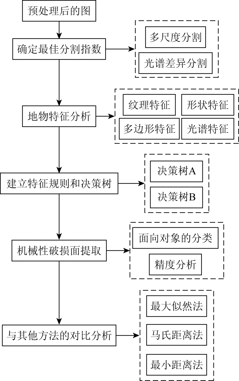
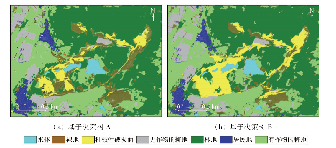
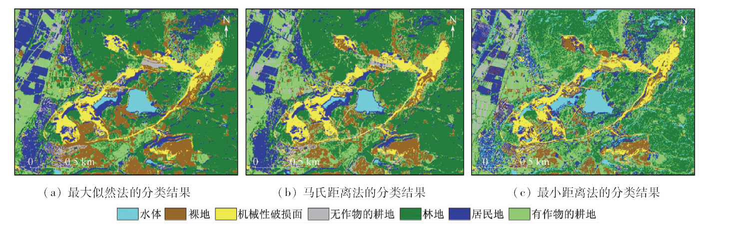
Abstract  

Mechanical damaged surface tends to cause soil erosion, secondary geological hazards and other ecological environment problems, but there is still a lack of effective extraction methods based on remote sensing images. Based on the GF-2 remote sensing image, the authors studied the object-oriented extraction method based on texture features in Tanglangchuan watershed with densely distributed mechanical damage surface. According to the seven types of features, the classification rules were established. On the basis of the optimal scale segmentation, the decision tree A based on spectral features and the decision tree B based on "spectral + texture" features are classified in object-oriented way. Precision evaluation and analysis show that, compared with the traditional supervised classification method and the spectral-based object-oriented classification method, the classification method improves the Kappa coefficient and the total accuracy to 0.82 and 86.25%, respectively, and also effectively improves the extraction accuracy of mechanical damage surface.

Keywords GF-2      mechanical damage surface      object-oriented classification      decision tree     
:  TP79  
Issue Date: 18 June 2020
Service
E-mail this article
E-mail Alert
RSS
Articles by authors
Jisheng XIA
Mengying MA
Zhongren FU
Cite this article:   
Jisheng XIA,Mengying MA,Zhongren FU. Extraction of mechanical damage surface using GF-2 remote sensing data[J]. Remote Sensing for Land & Resources, 2020, 32(2): 26-32.
URL:  
https://www.gtzyyg.com/EN/10.6046/gtzyyg.2020.02.04     OR     https://www.gtzyyg.com/EN/Y2020/V32/I2/26
Fig.1  Remote sensing image of research area
Fig.2  Flowchart of research methods
Fig.3  Image segmentation
指数 统计值 林地 水体 居民地 耕地(有植被) 耕地(无植被) 裸地 机械性破损面
最小值 0.08 -0.87 -1.00 0.05 -0.38 -0.06 -0.15

NDVI
最大值 1.00 -0.02 1.00 0.94 0.42 0.60 0.45
平均值 0.45 -0.69 0.10 0.32 0.15 0.15 0.05
标准差 0.14 0.07 0.09 0.24 0.07 0.09 0.03
最小值 -1.00 0.90 -0.64 -0.74 -0.45 -0.62 -0.57

NDWI
最大值 -0.09 0.06 -0.54 -0.52 -0.17 0.00 0.00
平均值 -0.50 0.77 -0.20 -0.67 -0.28 -0.28 -0.22
标准差 -0.08 0.07 -0.09 -0.04 -0.05 -0.08 -0.04
Stddev of length of 最小值 1.30 8.16 2.60 4.35 9.03 2.03 1.89
edges (polygon) 最大值 4.13 9.35 4.26 16.49 15.62 7.56 4.25

length/width
最小值 1.30 1.24 2.52 1.43 1.33 1.28 1.11
最大值 2.25 2.59 37.50 2.65 3.81 2.84 2.48
Tab.1  Characteristic indices of various types of land features
Fig.4  GLCM texture characteristic diagram
纹理特征值 均值 方差 对比度 相异性 信息熵 同质度
JM距离 1.29 1.28 1.86 0.65 0.67 1.82
转换分离度 1.71 1.98 1.98 0.97 0.75 1.94
Tab.2  Separable parameter table of texture features
类别 分类规则
水体 (0.35<NDWI<0.8) and (110<mean NIR<220)
林地 (0.2<NDVI<0.7) and (Stddev of length of edges (polygon)<4)
有作物的耕地 (0.2<NDVI<0.7) and (Stddev of length of edges (polygon)≥4)
居民地 (NDVI≥0.7 or NDVI≤0.2) and (length/width<2.8 or length/width>35) and (600<mean NIR<1 500)
无作物的耕地 (meanNIR≥1 500 or meanNIR≤600) and (2.8≤length/width≤35)and (8<Stddev of length of edges (polygon)<52)
裸地 (NDVI≥0.07 and NDVI≤0.01)
机械性破损面 (Stddev of length of edges (polygon)≤8 or Stddev of length of edges (polygon)≥52) and (0.01<NDVI<0.07)
and (contrast>1 000) and (Homogeneity<0.07)
Tab.3  Classification Rules of Terrain Objects
Fig.5  Object-oriented classification results based on decision tree A and decision tree B
土地利用
类型
决策树A 决策树B
用户精
度/%
制图精
度/%
用户精
度/%
制图精
度/%
裸地 83.56 83.56 87.33 84.42
机械性破损面 86.43 86.53 89.63 86.83
总体精度/% 78.34 86.25
Kappa系数 0.73 0.82
Tab.4  Comparison of extraction accuracy of mechanical damage surface between decision tree A and decision tree B
Fig.6  Comparison of the results of different supervised classification methods
精度 基于像元的监督分类 面向对象分类
最小距
离法
马氏距
离法
最大似
然法
基于光谱
的决策树A
基于“光谱+
纹理”的
决策树B
总体精度/% 70.21 72.67 74.53 78.34 86.25
Kappa系数 0.60 0.62 0.65 0.73 0.82
Tab.5  Accuracy comparison between object-oriented classification and supervised classification
[1] 陈佳俊. 基于GF-2卫星影像的川东丘陵地区耕地信息提取[D]. 成都:成都理工大学, 2017.
[1] Chen J J. Extraction of cultivated land information in hilly area of Eastern Sichuan based on GF-2 satellite image[D]. Chengdu:Chengdu University of Technology, 2017.
[2] 王蕾, 杨武年, 任金铜, 等. GF-2影像面向对象典型城区地物提取方法[J].测绘通报, 2018(1):138-142.
[2] Wang L, Yang W, Ren J T, et al. Object-oriented typical urban area object extraction method for GF-2 image[J].Surveying and Mapping Bulletin, 2018(1):138-142.
[3] Ouyang H L, Shen J W, Zhou T G. Application of object-oriented classification method to typhoon disaster information extraction[J]. Journal of Natural Disasters, 2016,25(6):9-17.
[4] Xu F N, Qi Y, Wang J H, et al. Riparian forest vegetation coverage information classification based on object-oriented method in Heihe River[J]. Remote Sensing Technology and Application, 2015. 30(5):996-1005.
[5] 戴莉莉, 李海涛, 顾海燕, 等. 特征优选下的遥感影像面向对象分类规则构建[J]. 测绘科学, 2019,44(02):26-32.
[5] Dai L L, Li H T, Gu H Y, et al. Construction of object-oriented classification rules for remote sensing images based on feature selection[J]. Surveying and Mapping Science, 2019,44(2):26-32.
[6] 贾伟, 高小红, 杨灵玉, 等. 面向对象方法的复杂地形区地表覆盖信息提取[J]. 兰州大学学报(自然科学版), 2018,54(4):486-493.
[6] Jia W, Gao X H, Yang L Y, et al. Object-oriented extraction of surface cover information in complex terrain area[J]. Journal of Lanzhou University:Natural Science Edition, 2018,54(4):486-493.
[7] 张金盈, 姚光虎, 林琳, 等. 结合主动学习和词袋模型的高分二号遥感影像自动化分类[J]. 测绘通报, 2019,20(2):103-107.
[7] Zhang J Y, Yao G H, Lin L, et al. Combined with active learning and word bag model,automatic classification of high-score remotesensing image No.2[J]. Surveying and Mapping Bulletin, 2019,20(2):103-107.
[8] 朱海涛, 张霞, 王树东, 等. 基于面向对象决策树算法的半干旱地区遥感影像分类[J]. 遥感信息, 2013,28(4):50-56.
[8] Zhu H T, Zhang X, Wang S D, et al. Classification of remote sensing images in semi-arid areas based on object-oriented decision tree algorithm[J]. Remote sensing information, 2013,28(4):50-56.
[9] 张华, 张改改, 吴睿. 基于GF-1卫星数据的面向对象的民勤绿洲植被分类研究[J]. 干旱区地理, 2017,40(4):831-838.
[9] Zhang H, Zhang G G, Wu R. Object-oriented classification of Minqin Oasis vegetation based on GF-1 satellite data[J]. Arid RegionGeography, 2017,40(4):831-838.
[10] 苏腾飞, 张圣微, 李洪玉. 基于纹理特征与区域生长的高分辨率遥感影像分割算法[J]. 国土资源遥感, 2017,29(2):72-81.doi: 10.6046/gtzyyg.2017.02.11.
[10] Su T F, Zhang S W, Li H Y. High resolution remote sensing image segmentation algorithm based on texture features and regional growth[J]. Land and Resources Remote Sensing, 2017,29(2):72-81.doi: 10.6046/gtzyyg.2017.02.11.
[11] 张东梅. 基于多尺度分割的土地利用分类研究[D]. 南昌:东华理工大学, 2017, 7-53.
[11] Zhang D M. Land use classification based on multi-scale segmentation[D]. Nanchang:East China University of Technology, 2017, 7-53.
[12] 王二丽, 李存军, 周静平, 等. 基于多时相遥感影像的北京平原人工林树种分类[J]. 北京工业大学学报, 2017,43(5):710-718.
[12] Wang E L, Li C J, Zhou J P, et al. Tree species classification of plantations in Beijing plain based on multi-temporal remote sensing images[J]. Journal of Beijing University of Technology, 2017,43(5):710-718.
[13] Moya L, Zakeri H, Yamazaki F, et al. 3D gray level co-occurrence matrix and its application to identifying collapsed buildings[J].Journal of Photogrammetry and Remote Sensing, 2019(149):14-28.
[14] Huang X, Liu X B, Zhang L P. A Multichannel gray level co-occurrence matrix for multi/hyperspectral image texture representation[J]. Remote Sensing. 2014,6(9):8424-8445.
[15] 何志强. 基于高分二号影像的面向对象分类技术研究[D]. 淮南:安徽理工大学, 2018, 9-33.
[15] He Z Q. Research on object-oriented classification technology based on GF-2 Image[D]. Huainan:Anhui University of Technology, 2018, 9-33.
[1] LIU Mingxing, LIU Jianhong, MA Minfei, JIANG Ya, ZENG Jingchao. Monitoring of Zanthoxylum bungeanum Maxim planting using GF-2 PMS images and the random forest algorithm: A case study of Linxia, Gansu Province[J]. Remote Sensing for Natural Resources, 2022, 34(1): 218-229.
[2] FAN Yinglin, LOU Debo, ZHANG Changqing, WEI Yingjuan, JIA Fudong. Information extraction technologies of iron mine tailings based on object-oriented classification: A case study of Beijing-2 remote sensing images of the Qianxi Area, Hebei Province[J]. Remote Sensing for Natural Resources, 2021, 33(4): 153-161.
[3] HU Guoqing, CHEN Donghua, LIU Congfang, XIE Yimei, LIU Saisai, LI Hu. Dynamic monitoring of urban black-odor water bodies based on GF-2 image[J]. Remote Sensing for Land & Resources, 2021, 33(1): 30-37.
[4] LIU Hui, QI Zengxiang, HUANG Fuqiang. Spatio-temporal difference and correlation of urbanization with avian habitats in Dongting Lake area[J]. Remote Sensing for Land & Resources, 2020, 32(3): 191-199.
[5] Wenya LIU, Anzhi YUE, Jue JI, Weihua SHI, Ruru DENG, Yeheng LIANG, Longhai XIONG. Urban green space extraction from GF-2 remote sensing image based on DeepLabv3+ semantic segmentation model[J]. Remote Sensing for Land & Resources, 2020, 32(2): 120-129.
[6] Gang DENG, Zhiguang TANG, Chaokui LI, Hao CHEN, Huanhua PENG, Xiaoru WANG. Extraction and analysis of spatiotemporal variation of rice planting area in Hunan Province based on MODIS time-series data[J]. Remote Sensing for Land & Resources, 2020, 32(2): 177-185.
[7] Linyan FENG, Bingxiang TAN, Xiaohui WANG, Xinyun CHEN, Weisheng ZENG, Zhao QI. Object-oriented rapid forest change detection based on distribution function[J]. Remote Sensing for Land & Resources, 2020, 32(2): 73-80.
[8] Liping YANG, Meng MA, Wei XIE, Xueping PAN. Fusion algorithm evaluation of Landsat 8 panchromatic and multispetral images in arid regions[J]. Remote Sensing for Land & Resources, 2019, 31(4): 11-19.
[9] Hui HUANG, Xiongwei ZHENG, Genyun SUN, Yanling HAO, Aizhu ZHANG, Jun RONG, Hongzhang MA. Seismic image classification based on gravitational self-organizing map[J]. Remote Sensing for Land & Resources, 2019, 31(3): 95-103.
[10] Jianyu LIU, Ling CHEN, Wei LI, Genhou WANG, Bo WANG. Application of the theory of structural hierarchy to the remote sensing geology[J]. Remote Sensing for Land & Resources, 2019, 31(3): 166-173.
[11] Feng FU, Xinjie WANG, Jin WANG, Na WANG, Jihong TONG. Tree species and age groups classification based on GF-2 image[J]. Remote Sensing for Land & Resources, 2019, 31(2): 118-124.
[12] Zhen CHEN, Yunshi ZHANG, Yuanyu ZHANG, Lingling SANG. A study of remote sensing monitoring methods for the high standard farmland[J]. Remote Sensing for Land & Resources, 2019, 31(2): 125-130.
[13] Chao MA, Fei YANG, Xuecheng WANG. Extracting tea plantations in southern hilly and mountainous region based on mesoscale spectrum and temporal phenological features[J]. Remote Sensing for Land & Resources, 2019, 31(1): 141-148.
[14] Jing LI, Qiangqiang SUN, Ping ZHANG, Danfeng SUN, Li WEN, Xianwen LI. A study of auxiliary monitoring in iron and steel plant based on multi-temporal thermal infrared remote sensing[J]. Remote Sensing for Land & Resources, 2019, 31(1): 220-228.
[15] Xianyu GUO, Kun LI, Zhiyong WANG, Hongyu LI, Zhi YANG. Fine classification of rice with multi-temporal compact polarimetric SAR based on SVM+SFS strategy[J]. Remote Sensing for Land & Resources, 2018, 30(4): 20-27.
Viewed
Full text


Abstract

Cited

  Shared   
  Discussed   
京ICP备05055290号-2
Copyright © 2017 Remote Sensing for Natural Resources
Support by Beijing Magtech