|
|
|
|
|
|
Extracting tea plantations in southern hilly and mountainous region based on mesoscale spectrum and temporal phenological features |
Chao MA1,2, Fei YANG1(), Xuecheng WANG1,2 |
1.Institute of Geographic Sciences and Natural Resources Research, CAS, State Key Laboratory of Resources and Environmental Information System, Beijing 100101, China 2.University of Chinese Academy of Sciences, Beijing 100049, China |
|
|
Abstract 
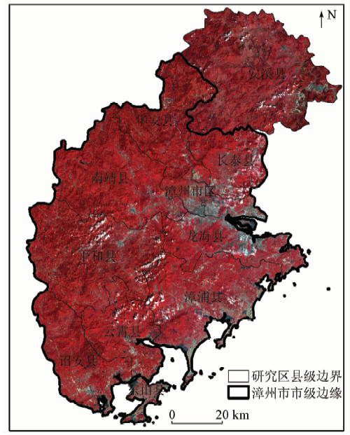
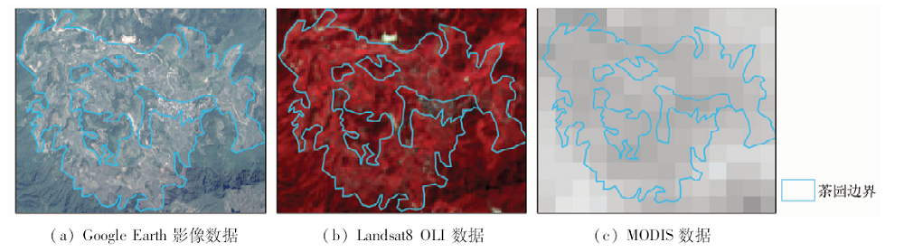
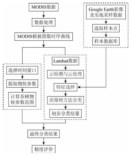
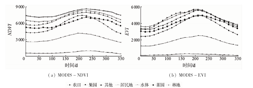
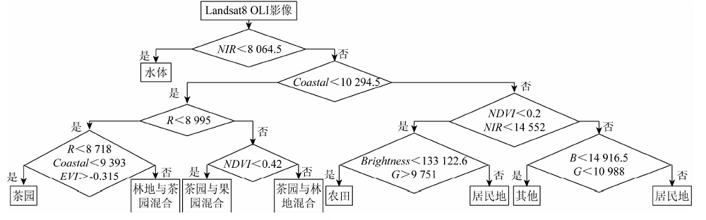
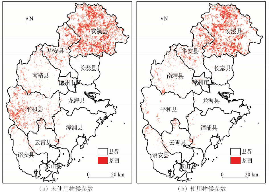
The extraction of the spatial distribution of tea plantations in hilly areas of southern China is of great importance for economic development and ecological environment protection in southern China. Therefore, a method of tea plantation based on mesoscale spectrum and temporal phenology characteristics is proposed. The study used MODIS enhanced vegetation index (EVI) and normalized difference vegetation index (NDVI) data products to select the optimal time window for Landsat images. The preliminary classification results were extracted using the object-oriented method and the decision tree classification model. For extracting the distribution of tea plantation, different vegetation phenology parameters were obtained by using MODIS-EVI vegetation timing data. Verification results showed that the overall classification accuracy reached 85.71% and the Kappa coefficient reached 0.83, with the accuracy of tea plantation producers reaching 83.72% and the user precision reaching 90.00%. The extraction results are close to the open statistics of tea plantation area in Zhangzhou City and Anxi County. The results show that this method can obtain high tea plantation extraction accuracy and the classification results can provide some reference and guidance for the economic development of southern China and the government departments' regulation of the tea plantation.
|
Keywords
remote sensing
object-oriented method
tea plantations
phenological parameters
decision tree
|
|
Corresponding Authors:
Fei YANG
E-mail: yangfei@lreis.ac.cn
|
Issue Date: 14 March 2019
|
|
|
[1] |
韩旭 . 中国茶叶种植地域的历史变迁研究[D]. 杭州:浙江大学, 2013.
|
[1] |
Han X . A Study on the Changes in Tea Planting Regions in the History of China[D]. Hangzhou:Zhejiang University, 2013.
|
[2] |
陈明枢, 吕居永, 冯廷佺 , 等. 漳州市华安等4个老区县茶产业发展情况调研报告[J]. 福建茶叶, 2013,35(1):2-4.
doi: 10.3969/j.issn.1005-2291.2013.01.001
url: http://d.wanfangdata.com.cn/Periodical_fjcy201301001.aspx
|
[2] |
Chen M S, Lyu J Y, Feng T Q , et al. Investigation report on the development of tea industry in four old areas in Zhangzhou City[J]. Tea in Fujian, 2013,35(1):2-4.
|
[3] |
任冲, 鞠洪波, 张怀清 , 等. 多源数据林地类型的精细分类方法[J]. 林业科学, 2016,52(6):54-65.
doi: 10.11707/j.1001-7488.20160607
url: http://www.cnki.com.cn/Article/CJFDTotal-LYKE201606007.htm
|
[3] |
Ren C, Ju H B, Zhang H Q , et al. Multi-source data for forest land type precise classification[J]. Scientia Silvae Sinicae, 2016,52(6):54-65.
|
[4] |
高孟绪, 王卷乐, 柏中强 , 等. 基于RapidEye影像的农村居民地遥感监测———以江西省泰和县为例[J]. 国土资源遥感, 2016,28(1):130-135.doi: 10.6046/gtzyyg.2016.01.19.
doi: 10.6046/gtzyyg.2016.01.19
url: http://www.cqvip.com/QK/91397X/201601/668153369.html
|
[4] |
Gao M X, Wang J L, Bai Z Q , et al. Remote sensing monitoring of rural residential land based on RapidEye satellite images:A case study of Taihe County,Jiangxi Province[J]. Remote Sensing for Land and Resources, 2016,28(1):130-135.doi: 10.6046/gtzyyg.2016.01.19.
|
[5] |
Aplin P . Remote sensing:Land cover[J]. Progress in Physical Geography, 2004,28(2):283-293.
|
[6] |
Wang L, Sousa W P, Gong P . Integration of object-based and pixel-based classification for mapping mangroves with IKONOS imagery[J]. International Journal of Remote Sensing, 2004,25(24):5655-5668.
doi: 10.1080/014311602331291215
url: https://www.tandfonline.com/doi/full/10.1080/014311602331291215
|
[7] |
刘晓娜, 封志明, 姜鲁光 . 基于决策树分类的橡胶林地遥感识别[J]. 农业工程学报, 2013,29(24):163-172,365.
doi: 10.3969/j.issn.1002-6819.2013.24.022
url: http://d.wanfangdata.com.cn/Periodical/nygcxb201324022
|
[7] |
Liu X N, Feng Z M, Jiang L G . Application of decision tree classification to rubber plantations extraction with remote sensing[J]. Transactions of the Chinese Society of Agricultural Engineering, 2013,29(24):163-172,365.
|
[8] |
徐岳仁, 何宏林, 陈立泽 , 等. 基于CBERS数据的福建南平地质灾害动态遥感解译[J]. 国土资源遥感, 2014,26(3):153-159.doi: 10.6046/gtzyyg.2014.03.25.
doi: 10.6046/gtzyyg.2014.03.25
url: http://www.cqvip.com/QK/91397X/201403/662181311.html
|
[8] |
Xu Y R, He H L, Chen L Z , et al. Dynamic remote sensing interpretation of geological disasters in Nanping City of Fujian Province using CBERS serial data[J]. Remote Sensing for Land and Resources, 2014,26(3):153-159.doi: 10.6046/gtzyyg.2014.03.25.
|
[9] |
刘晓娜, 封志明, 姜鲁光 , 等. 西双版纳橡胶林地的遥感识别与数字制图[J]. 资源科学, 2012,34(9):1769-1780.
url: http://d.wanfangdata.com.cn/Periodical/zykx201209020
|
[9] |
Liu X N, Feng Z M, Jiang L G , et al. Rubber plantations in Xishuangbanna:Remote sensing identification and digital mapping[J]. Resources Science, 2012,34(9):1769-1780.
|
[10] |
Rao N R, Kapoor M, Sharma N , et al. Yield prediction and waterlogging assessment for tea plantation land using satellite image-based techniques[J]. International Journal of Remote Sensing, 2007,28(7-8):1561-1576.
doi: 10.1080/01431160600904980
url: https://www.tandfonline.com/doi/full/10.1080/01431160600904980
|
[11] |
Dihkan M, Guneroglu N, Karsli F , et al. Remote sensing of tea plantations using an SVM classifier and pattern-based accuracy assessment technique[J]. International Journal for Remote Sensing, 2013,34(23):8549-8565.
doi: 10.1080/01431161.2013.845317
url: https://www.tandfonline.com/doi/full/10.1080/01431161.2013.845317
|
[12] |
Dutta R, Stein A, Patel N R . Delineation of diseased tea patches using MXL and texture based classification[J]. The International Archives of the Photogrammetry,Remote Sensing and Spatial Information Sciences, 2008,37(B4):1693-1700.
|
[13] |
徐伟燕, 孙睿, 金志凤 . 基于资源三号卫星影像的茶树种植区提取[J]. 农业工程学报, 2016,32(s1):161-168.
doi: 10.11975/j.issn.1002-6819.2016.z1.023
url: http://www.cnki.com.cn/Article/CJFDTotal-NYGU2016S1023.htm
|
[13] |
Xu W Y, Sun R, Jin Z F . Extracting tea plantations based on ZY-3 satellite data[J]. Transactions of the Chinese Society of Agricultural Engineering, 2016,32(s1):161-168.
|
[14] |
裴志远, 杨邦杰 . 多时相归一化植被指数NDVI的时空特征提取与作物长势模型设计[J]. 农业工程学报, 2000,16(5):20-22.
doi: 10.3321/j.issn:1002-6819.2000.05.005
url: http://www.cnki.com.cn/Article/CJFDTotal-NYGU200005004.htm
|
[14] |
Pei Z Y, Yang B J . Analysis of multi-temporal and multi-spatial character of NDVI and crop condition models development[J]. Transactions of the Chinese Society of Agricultural Engineering, 2000,16(5):20-22.
|
[15] |
徐爽, 沈润平, 杨晓月 . 利用不同植被指数估算植被覆盖度的比较研究[J]. 国土资源遥感, 2012,24(4):95-100.doi: 10.6046/gtzyyg.2012.04.16.
doi: 10.6046/gtzyyg.2012.04.16
url: http://www.cnki.com.cn/Article/CJFDTotal-GTYG201204017.htm
|
[15] |
Xu S, Shen R P, Yang X Y . A comparative study of different vegetation indices for estimating vegetation coverage based on the dimidiate pixel model[J]. Remote Sensing for Land and Resources, 2012,24(4):95-100.doi: 10.6046/gtzyyg.2012.04.16.
|
[16] |
Rouse J W J, Haas R H, Schell J A , et al. Monitoring vegetation systems in the great plains with ERTS[J]. Nasa Special Publication, 1973,351:309-317.
url: http://adsabs.harvard.edu/abs/1974NASSP.351..309R
|
[17] |
刘昌振, 舒红, 张志 , 等. 基于多尺度分割的高分遥感图像变异函数纹理提取和分类[J]. 国土资源遥感, 2015,27(4):47-53.doi: 10.6046/gtzyyg.2015.04.08.
doi: 10.6046/gtzyyg.2015.04.08
url: http://www.cqvip.com/QK/91397X/201504/666795390.html
|
[17] |
Liu C Z, Shu H, Zhang Z , et al. Variogram texture extraction and classification of high resolution remote sensing images based on multi-resolution segmentation[J]. Remote Sensing for Land and Resources, 2015,27(4):47-53.doi: 10.6046/gtzyyg.2015.04.08.
|
[18] |
Rathcke B, Elizabeth P L . Phenological patterns of terrestrial plants[J]. Annual Review of Ecology and Systematics, 1985,16:179-214.
doi: 10.1146/annurev.es.16.110185.001143
url: http://www.annualreviews.org/doi/10.1146/annurev.es.16.110185.001143
|
[19] |
范德芹, 赵学胜, 朱文泉 , 等. 植物物候遥感监测精度影响因素研究综述[J]. 地理科学进展, 2016,35(3):304-319.
doi: 10.18306/dlkxjz.2016.03.005
url: http://www.cqvip.com/QK/96015A/201603/668498021.html
|
[19] |
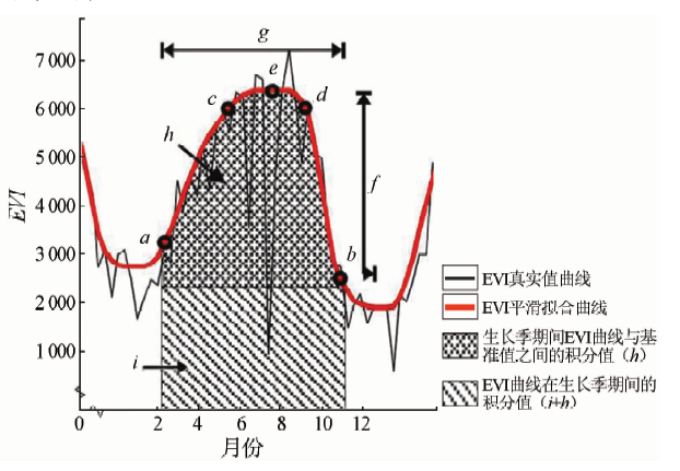
Fan D Q, Zhao X S, Zhu W Q , et al. Review of influencing factors of accuracy of plant phenology monitoring based on remote sensing data[J]. Progress in Geography, 2016,35(3):304-319.
|
[20] |
李红军, 郑力, 雷玉平 , 等. 基于EOS/MODIS数据的NDVI与EVI比较研究[J]. 地理科学进展, 2007,26(1):26-32.
doi: 10.3969/j.issn.1007-6301.2007.01.003
url: http://d.wanfangdata.com.cn/Periodical_dlkxjz200701003.aspx
|
[20] |
Li H J, Zheng L, Lei Y P , et al. Comparison of NDVI and EVI based on EOS/MODIS data[J]. Progress in Geography, 2007,26(1):26-32.
|
[21] |
王正兴, 刘闯 , Huete A. 植被指数研究进展:从AVHRR-NDVI到MODIS-EVI[J]. 生态学报, 2003,23(5):979-987.
doi: 10.3321/j.issn:1000-0933.2003.05.020
url: http://doi.med.wanfangdata.com.cn/qk/stxb200305020
|
[21] |
Wang Z X, Liu C, Huete A . From AVHRR-NDVI to MODIS-EVI:Advances in vegetation index research[J]. Acta Ecologica Sinica, 2003,23(5):979-987.
|
[22] |
辜智慧 . 中国农作物复种指数的遥感估算方法研究——基于SPOT/VGT多时相NDVI遥感数据[D]. 北京:北京师范大学, 2003.
|
[22] |
Gu Z H . A Study of Calculating Multiple Cropping Index of Crop in China Using SPOT/VGT Multi Temporal NDVI Data[D]. Beijing:Beijing Normal University, 2003.
|
[23] |
王学成, 杨飞, 高星 , 等. 基于NDVI阈值法的森林冰冻受灾范围精确提取[J]. 地球信息科学学报, 2017,19(4):549-558.
doi: 10.3969/j.issn.1560-8999.2017.04.013
url: http://d.wanfangdata.com.cn/Periodical/dqxxkx201704013
|
[23] |
Wang X C, Yang F, Gao X , et al. Precise extraction of damaged forest range caused by ice-snow frozen disaster based on the NDVI threshold method[J]. Journal of Geo-Information Science, 2017,19(4):549-558.
|
[24] |
康峻, 侯学会, 牛铮 , 等. 基于拟合物候参数的植被遥感决策树分类[J]. 农业工程学报, 2014,30(9):148-156.
doi: 10.3969/j.issn.1002-6819.2014.09.019
url: http://www.cnki.com.cn/Article/CJFDTotal-NYGU201409019.htm
|
[24] |
Kang J, Hou X H, Niu Z , et al. Decision tree classification based on fitted phenology parameters from remotely sensed vegetation data[J]. Transactions of the Chinese Society of Agricultural Engineering, 2014,30(9):148-156.
|
[25] |
平跃鹏 . 基于MODIS时间序列地表物候特征分析及农作物分类[D]. 哈尔滨:哈尔滨师范大学, 2016.
|
[25] |
Ping Y P . Crop Classification Based on Analysis of Phenological Characteristics of MODIS Times Series[D]. Harbin:Harbin Normal University, 2016.
|
[26] |
Savitzky A, Golay M J E, . Smoothing and differentiation of data by simplified least squares procedures.[J]. Analytical Chemistry, 1964,36(8):1627-1639.
doi: 10.1021/ac60214a047
url: http://pubs.acs.org/doi/abs/10.1021/ac60214a047
|
[27] |
Lloyd D . A phenological classification of terrestrial vegetation cover using shortwave vegetation index imagery[J]. International Journal of Remote Sensing, 1990,11(12):2269-2279.
doi: 10.1080/01431169008955174
url: https://www.tandfonline.com/doi/full/10.1080/01431169008955174
|
|
Viewed |
|
|
|
Full text
|
|
|
|
|
Abstract
|
|
|
|
|
Cited |
|
|
|
|
|
Shared |
|
|
|
|
|
Discussed |
|
|
|
|