|
|
 |
|

|
|
|
Fusion algorithm evaluation of Landsat 8 panchromatic and multispetral images in arid regions |
| Liping YANG1, Meng MA2, Wei XIE2, Xueping PAN2 |
1. School of Geological Engineering and Geomatics, Chang’an University, Xi’an 710054, China;
2. School of Earth Sciences and Resources, Chang’an University, Xi’an 710054, China; |
|
|
|
|
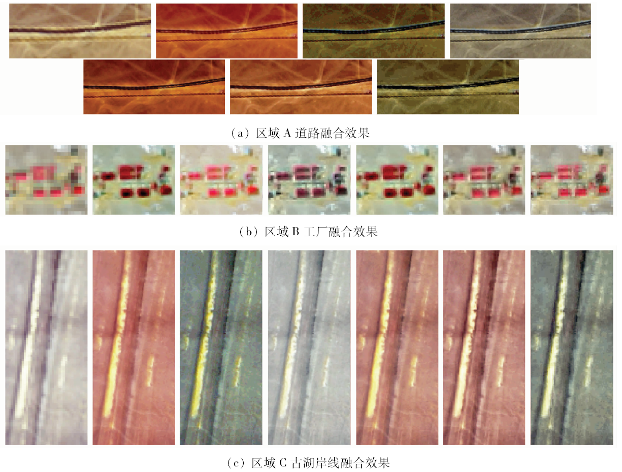
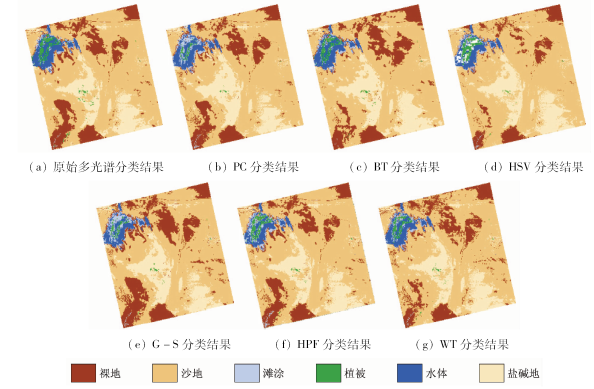
Abstract With lower contrast and confidence level, single factor evaluation index is not very effective in the comprehensive evaluation of pixel level image fusion algorithms of Landsat 8 in arid regions. Based on the Landsat 8 image of Juyanze area, 11 single factor indicators and object-oriented classification method were used to compare the following six image fusion algorithms, i.e., Principal Component (PC), Brovey Transform (BT), Hue-Saturation-Value Transform (HSV), Gram-Schmidt Pan Sharpening (G-S), High-pass filtering(HPF) and Wavelet Transform (WT) according to the spatial information quantity, spectral feature and classification accuracy. The results indicate that the spatial resolution and texture features of all fusion images are enhanced in comparison with the original image. HSV is proved to be the best algorithm to highlight the texture features in arid regions, but its spectral fidelity is bad. WT exhibits an excellent capability in maintaining the spectral information, and its capability of revealing spatial details is just next to the HSV method. Therefore, WT is considered the most suitable algorithm for image fusion of Landsat 8 in this study. Taking the spatial information quantity and spectral features into account simultaneously, the authors hold that PC and G-S have moderate performance, and their performance is a little lower than that of HPF, while the performance of BT is the worst. The classification results show that the classification accuracy of WT and HPF is improved to some extent compared with the original image.
|
| Keywords
fusion algorithm
spectral information
spatial information
object-oriented classification
effect evaluation
|
|
|
|
Issue Date: 03 December 2019
|
|
|
| [1] |
翁永玲, 田庆久 . 遥感数据融合方法分析与评价综述[J].遥感信息,2003(3):49-54.
|
| [1] |
Weng Y L, Tian Q J . Analysis and evaluation of method on remote sensing data fusion[J].Remote Sensing Information,2003(3):49-54.
|
| [2] |
刘锟, 付晶莹, 李飞 . 高分一号卫星4种融合方法评价[J]. 遥感技术与应用, 2015,30(5):980-986.
doi: 10.11873/j.issn.1004-0323.2015.5.0980
|
| [2] |
Liu K, Fu J Y, Li F . Evaluation study of four fusion methods of GF-1 pan and multi-spectral images[J]. Remote Sensing Technology and Application, 2015,30(5):980-986.
|
| [3] |
郑雅兰, 王雷光, 陆翔 . 高分二号全色-多光谱影像融合方法对比研究[J]. 西南林业大学学报(自然科学版), 2018,38(2):103-111.
|
| [3] |
Zheng Y L, Wang L G, Lu X . Comparison of image fusion methods for GF-2 panchromatic-multispectral[J]. Natural Science of Southwest Forestry University, 2018,38(2):103-111.
|
| [4] |
邢元军, 刘晓农, 宋亚斌 , 等. 国产高分辨率遥感影像融合方法比较与分析[J]. 中南林业科技大学学报, 2016,36(10):83-88.
|
| [4] |
Xing Y J, Liu X N, Song Y B , et al. Research on fusion method comparison and analysis for domestic high resolution satellite images[J]. Journal of Central South University of Forestry and Technology, 2016,36(10):83-88.
|
| [5] |
郭蕾, 杨冀红, 史良树 , 等. SPOT6遥感图像融合方法比较研究[J]. 国土资源遥感, 2014,26(4):71-77.doi: 10.6046/gtzyyg.2014.04.12.
doi: 10.6046/gtzyyg.2014.04.12
|
| [5] |
Guo L, Yang Y H, Shi L S , et al. Comparative study of image fusion algorithms for SPOT6[J]. Remote Sensing for Land and Resources, 2014,26(4):71-77.doi: 10.6046/gtzyyg.2014.04.12.
|
| [6] |
杨丽萍, 夏敦胜, 陈发虎 . Landsat 7 ETM+全色与多光谱数据融合算法的比较[J]. 兰州大学学报(自然科学版), 2007,43(4):7-11.
|
| [6] |
Yang L P, Xia D S, Chen F H . On fusion algorithm of Landsat 7 ETM+ pan and multi-spectral images[J]. Natural Sciences of Lanzhou University, 2007,43(4):7-11.
|
| [7] |
谢士琴, 赵天忠, 王威 , 等. 高分二号卫星影像融合方法比较研究[J]. 系统仿真学报, 2017,29(11):2742-2746.
|
| [7] |
Xie S Q, Zhao T Z, Wang W , et al. Study on fusion algorithms of GF-2 satellite image[J]. Journal of System Simulation, 2017,29(11):2742-2746.
|
| [8] |
Song H H, Huang B, Liu Q S , et al. Improving the spatial resolution of Landsat TM/ETM+ through fusion with Spot5 images via learning-based super-resolution[J]. IEEE Transactions on Geoscience and Remote Sensing, 2014,53(3):1195-1204.
|
| [9] |
孙攀, 董玉森, 陈伟涛 , 等. 高分二号卫星影像融合及质量评价[J]. 国土资源遥感, 2016,28(4):108-113.doi: 10.6046/gtzyyg.2016.04.17.
doi: 10.6046/gtzyyg.2016.04.17
|
| [9] |
Sun P, Dong Y S, Chen W T , et al. Research on fusion of GF-2 imagery and quality evaluation[J]. Remote Sensing for Land and Resources, 2016,28(4):108-113.doi: 10.6046/gtzyyg.2016.04.17.
|
| [10] |
张兵, 崔希民, 韦锐 , 等. 基于RS与GIS多源数据融合的高原区地质调查研究[J]. 煤炭工程, 2016,48(3):99-102.
|
| [10] |
Zhang B, Cui X M, Wei R , et al. Multi-data fusion in geological survey and mapping in plateau area based on RS and GIS[J]. Coal Engineering, 2016,48(3):99-102.
|
| [11] |
姬永杰, 岳彩荣, 张王菲 . SAR数据与光学数据融合在土地覆盖分类中的应用研究[J]. 西南林业大学学报, 2016,36(3):158-162.
|
| [11] |
Ji Y J, Yue C R, Zhang W F . Use fusion of SAR and optical images for land cover classification[J]. Journal of Southwest Forestry University, 2016,36(3):158-162.
|
| [12] |
龚家栋, 程国栋, 张小由 , 等. 黑河下游额济纳地区的环境演变[J]. 地球科学进展, 2002,17(4):491-496.
|
| [12] |
Gong J D, Cheng G D, Zhang X Y , et al. Environmental changes of Ejina region in the lower reaches of Heihe river[J]. Advance In Earth Sciences, 2002,17(4):491-496.
|
| [13] |
张玉君 . Landsat 8简介[J]. 国土资源遥感, 2013,25(1):176-177.
|
| [13] |
Zhang Y J . Introduction to Landsat 8[J]. Remote Sensing for Land and Resources, 2013,25(1):176-177.
|
| [14] |
Welch R . Merging multiresolution Spot HRV and Landsat TM data[J]. Photogrammetric Engineering and Remote Sensing, 1987,53(3):301-303.
|
| [15] |
Vol. N . Multispectral imagery band sharpening study[J]. Photogrammetric Engineering and Remote Sensing, 1996,62(9):1075-1084.
|
| [16] |
Koutsias N, Karteris M, Chuvieco E . The use of intensity-hue-saturation transformation of Landsat-5 thematic mapper data for burned land mapping[J]. Photogrammetric Engineering and Remote Sensing, 2000,66(7):829-839.
|
| [17] |
Ehlers M, Klonus S, Åstrand P J , et al. Multi-sensor image fusion for pansharpening in remote sensing[J]. International Journal of Image and Data Fusion, 2010,1(1):25-45.
|
| [18] |
Schowengerdt R A . Reconstruction of multispatial, multispectral image data using spatial frequency content[J]. Photogrammetric Engineering and Remote Sensing, 1980,46(10):1325-1334.
|
| [19] |
Psjr C, Sides S C, Anderson J A . Comparison of three different methods to merge multiresolution and multispectral data:Landsat TM and SPOT panchromatic[J]. Photogrammetric Engineering and Remote Sensing, 1991,57(3):265-303.
|
| [20] |
周芳, 王鹏波, 李春升 . 遥感图像融合效果评估方法[J]. 现代雷达, 2013,35(3):19-23.
|
| [20] |
Zhou F, Wang P B, Li C S . Evaluation method of remote sensing image fusion effect[J]. Modern Radar, 2013,35(3):19-23.
|
| [21] |
阳方林, 郭红阳, 杨风暴 . 像素级图像融合效果的评价方法研究[J]. 测试技术学报, 2002,16(4):276-279.
|
| [21] |
Yang F L, Guo H Y, Yang F B . Study of evaluation methods on effect of pixel-level image fusion[J]. Journal of test and measurement technology, 2002,16(4):276-279.
|
| [22] |
狄红卫, 刘显峰 . 基于结构相似度的图像融合质量评价[J]. 光子学报, 2006,35(5):766-771.
url: http://www.opticsjournal.net/Articles/Abstract?aid=OJ061025000035HdKgMj
|
| [22] |
Di H W, Liu X F . Image fusion assessment based on structural similarity[J]. Acta Photonica Sinica, 2006,35(5):766-771.
|
| [23] |
刘家福, 刘吉平, 姜海玲 . eCognition数字图像处理方法[M]. 北京: 科学出版社, 2017: 56-62.
|
| [23] |
Liu J F, Liu J P, Jiang H L. Ecognition digital image processing method[M]. Beijing: Science Press, 2017: 56-62.
|
|
Viewed |
|
|
|
Full text
|
|
|
|
|
Abstract
|
|
|
|
|
Cited |
|
|
|
|
| |
Shared |
|
|
|
|
| |
Discussed |
|
|
|
|
 2019,
Vol. 31
2019,
Vol. 31