|
|
 |
|

|
|
|
Seismic image classification based on gravitational self-organizing map |
Hui HUANG1,2, Xiongwei ZHENG3, Genyun SUN1,2( ), Yanling HAO1,2, Aizhu ZHANG1,2, Jun RONG1,2, Hongzhang MA4 ), Yanling HAO1,2, Aizhu ZHANG1,2, Jun RONG1,2, Hongzhang MA4 |
1. School of Geosciences, China University of Petroleum, Qingdao 266580, China
2. Laboratory for Marine Resources Qingdao National Laboratory for Marine Science and Technology, Qingdao, 266071, China
3. China Aero Geophysical Survey and Remote Sensing Center for Natural Resources, Beijing 100083, China
4. College of Science, China University of Petroleum, Qingdao 266580, China |
|
|
|
|
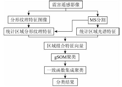
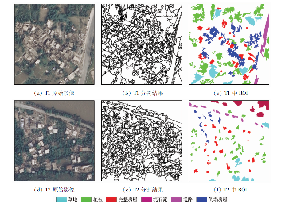
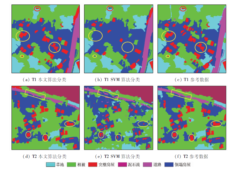
Abstract The recognition and extraction of seismic targets in high resolution post-earthquake images pose great challenge to the traditional image classification method. This paper introduces an object-oriented classification method for high resolution post-earthquake images classification, which integrates fractal texture features into a gravitational self-organizing map (gSOM). The method can be summarized as follows. First of all, the mean shift (MS) segmentation algorithm is adopted for initial segmentation in order to obtain homogeneous geographical objects, and the objects are regarded as the basic classification units in the subsequent process. Secondly, the characteristics of objects are quantified by the adaptive combination of the spectral bands and the fractal second order statistics as the texture information extracted from the original seismic image. Finally, the objects as classification units are clustered under the gSOM. For the purpose of controlling the uncertainty in the classification results, these various clustered results are assembled by the consensus function with the least cost. The qualitative and quantitative experiments on the Wenchuan County seismic images demonstrate the effectiveness and accuracy of the proposed method, which not only maintains the integrity of large damage targets, but also reflects details of the small targets at the same time. Also, the method shows the potential in the new technology for high resolution post-event image classification.
|
| Keywords
fractal texture
gSOM
high resolution remote sensing
seismic targets
object-oriented classification
|
|
|
|
Corresponding Authors:
Genyun SUN
E-mail: genyunsun@163.com
|
|
Issue Date: 30 August 2019
|
|
|
| [1] |
Dong L, Shan J . A comprehensive review of earthquake-induced building damage detection with remote sensing techniques[J]. ISPRS Journal of Photogrammetry and Remote Sensing, 2013,84:85-99.
|
| [2] |
Vu T T .Rapid disaster damage estimation[C]//International Archives of the Photogrammetry,Remote Sensing and Spatial Information Sciences, 2012, xxxix-b8:65-69.
|
| [3] |
Liu J H, Shan X J, Yin J Y . Automatic recognition of damaged town buildings caused by earthquake using remote sensing information:Taking the 2001 Bhuj,India,earthquake and the 1976 Tangshan,China,earthquake as examples[J]. Acta Seismologica Sinica, 2004,17(6):686-696.
|
| [4] |
Li X, Yang W, Ao T , et al. An improved approach of information extraction for earthquake-damaged buildings using high-resolution imagery[J]. Journal of Earthquake and Tsunami, 2012,5(4):389-399.
|
| [5] |
Fukuoka T , Koshimura S.Quantitative analysis of tsunami debris by object-based image classification of the aerial photo and satellite image[J]. Journal of Japan Society of Civil Engineers Ser B2, 2012, 68:I_371-I_375.
|
| [6] |
Vatsavai R, Tuttle M, Bhaduri B , et al. Rapid damage assessment using high-resolution remote sensing imagery:Tools and techniques [C]//Proceedings of the IEEE International Geoscience and Remote Sensing Symposium.IEEE, 2011: 1445-1448.
|
| [7] |
Cheng J, Li L, Luo B , et al. High-resolution remote sensing image segmentation based on improved RIU-LBP and SRM[J]. Eurasip Journal on Wireless Communications and Networking, 2013,2013(1):1-12.
|
| [8] |
Kuldeep, Garg P K . Texture based information extraction from high resolution images using object based classification approach [C]//Proceedings of the International Workshop on Earth Observation and Remote Sensing Applications, 2014: 299-303.
|
| [9] |
Backes A R, Casanova D, Bruno O M . Color texture analysis based on fractal descriptors[J]. Pattern Recognition, 2012,45(5):1984-1992.
|
| [10] |
Florindo J B, Bruno O M . Texture analysis by multi-resolution fractal descriptors[J]. Expert Systems with Applications, 2013,40(10):4022-4028.
|
| [11] |
Pentland A P . Fractal-based description of natural scenes[J]. IEEE Transactions on Pattern Analysis and Machine Intelligence, 1983,6(6):661-674.
|
| [12] |
魏向辉 . 基于分形理论的遥感影像土地利用分类研究[D]. 北京:中国地质大学(北京), 2016.
|
| [12] |
Wei X H . Study on Classification of Land Use with Remote Sensing Image Based on Fractal Theory[D]. Beijing:China University of Geosciences(Beijing), 2016.
|
| [13] |
杨骇, 韩留生, 陈水森 , 等. 一种基于城市水体指数与分形几何算法的OLI遥感影像水体提取方法[J].测绘通报, 2018(4):44-49.
|
| [13] |
Yang H, Han L S, Chen S S , et al. Extracting water information from OLI remote sensing images based on city water index and fractal geometry[J].Bulletin of Surveying and Mapping, 2018(4):44-49.
|
| [14] |
Filippi A, Klein A G, Dobreva I , et al. Self-Organizing Map-Based Applications in Remote Sensing[M]. INTECH Open Access Publisher, 2010.
|
| [15] |
Jain D K, Dubey S B, Choubey R K , et al. An approach for hyperspectral image classification by optimizing SVM using self organizing map[J]. Journal of Computational Science, 2017,25:252-259.
|
| [16] |
Cracknell M J, Reading A M, Caritat P D . Multiple influences on regolith characteristics from continental-scale geophysical and mineralogical remote sensing data using self-organizing maps[J]. Remote Sensing of Environment, 2015,165:86-99.
|
| [17] |
Ilc N, Dobnikar A . Generation of a clustering ensemble based on a gravitational self-organising map[J]. Neurocomputing, 2012,96(1):47-56.
|
| [18] |
Tao W, Jin H, Zhang Y . Color image segmentation based on mean shift and normalized cuts[J]. IEEE Transactions on Cybernetics, 2007,37(5):1382-1389.
|
| [19] |
余国斌, 陈爱斌, 孙华 , 等. 基于Mean Shift的高分辨率遥感影像分割方法[J]. 中南林业科技大学学报, 2012,32(10):168-172.
|
| [19] |
Yu G B, Chen A B, Sun H , et al. High-resolution remote sensing image segmentation approach based on mean shift[J]. Journal of Central South University of Forestry and Technology, 2012,32(10):168-172.
|
| [20] |
曹帆之, 朱述龙, 朱宝山 , 等. 均值漂移与卡尔曼滤波相结合的遥感影像道路中心线追踪算法[J]. 测绘学报, 2016,45(2):205-212.
|
| [20] |
Can F Z, Zhu S L, Zhu B S , et al. Tracking road centerlines from remotely sensed imagery using mean shift and Kalman filtering[J]. Acta Geodaetica et Cartographica Sinica, 2016,45(2):205-212.
|
| [21] |
Ming D P, Ci T Y, Cai H , et al. Semivariogram-based spatial bandwidth selection for remote sensing image segmentation with mean-shift algorithm[J]. IEEE Geoscience and Remote Sensing Letters, 2012,9(5):813-817.
|
| [22] |
Mandelbrot B B . Self-affine fractals and fractal dimension[J]. Phys Scripta, 1985,32(4):257-260.
|
| [23] |
Florindo J B, Backes A R, Castro M D , et al. A comparative study on multiscale fractal dimension descriptors[J]. Pattern Recognition Letters, 2012,33(6):798-806.
|
| [24] |
Julesz B , Experiments in the visual perception of texture[J]. Scientific American, 1975,232(4):34-43.
|
| [25] |
Azimi J, Fern X . Adaptive cluster ensemble selection[J]. Statistical Analysis and Data Mining the Asa Data Science Journal, 2009,1(3):128-141.
|
| [26] |
Fern X Z, Brodley C E . Solving cluster ensemble problems by bipartite graph partitioning [C]//Proceedings of the International Conference on Machine Learning, 2004: 36.
|
| [27] |
Fern X Z, Wei L . Cluster ensemble selection[J]. Statistical Analysis and Data Mining, 2008,1(3):128-141.
|
| [28] |
Vega-Pons S, Correa-Morris J, Ruiz-Shulcloper J . Weighted Cluster Ensemble Using a Kernel Consensus Function[M]. Springer Berlin Heidelberg, 2008.
|
| [29] |
罗会兰, 危辉 . 一致性函数研究[J]. 计算机工程与应用, 2009,45(17):1-4.
doi: 10.3778/j.issn.1002-8331.2009.17.001
|
| [29] |
Luo H L, Wei H . Study on consensus function based on clustering algorithms of categorical data. Computer Engineering and Applications, 2009,45(17):1-4.
|
| [30] |
Strehl A, Ghosh J . Relationship-Based Clustering and Visualization for High-Dimensional Data Mining[M]. INFORMS, 2003.
|
|
Viewed |
|
|
|
Full text
|
|
|
|
|
Abstract
|
|
|
|
|
Cited |
|
|
|
|
| |
Shared |
|
|
|
|
| |
Discussed |
|
|
|
|
 2019,
Vol. 31
2019,
Vol. 31