|
|
 |
|

|
|
|
Subsidence monitoring of Huainan coal mine from Sentinel TOPS images based on Stacking technique |
| Xiaobo ZHANG1, Xuesheng ZHAO2, Daqing GE3, Bin LIU3, Ling ZHANG3, Man LI3, Yan WANG3 |
1. School of Ecology and Environment, Institute of Disaster Prevention, Langfang 101601, China
2. College of Geoscience and Surveying Engineering, China University of Mining and Technology (Beijing), Beijing 100083, China
3. China Aero Geophysical Survey and Remote Sensing for Land and Resources, Beijing 100083, China |
|
|
|
|
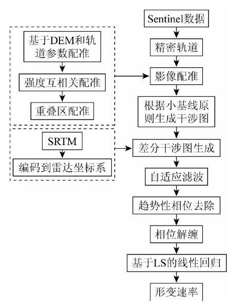
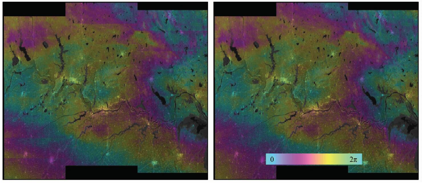
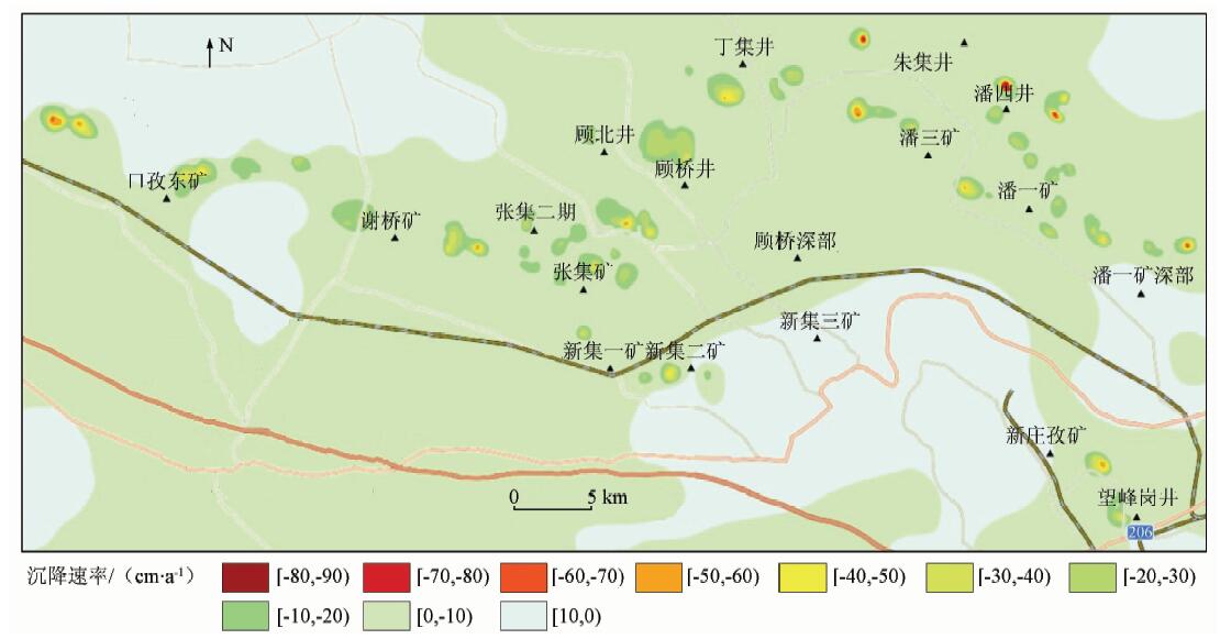
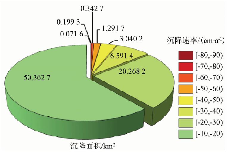
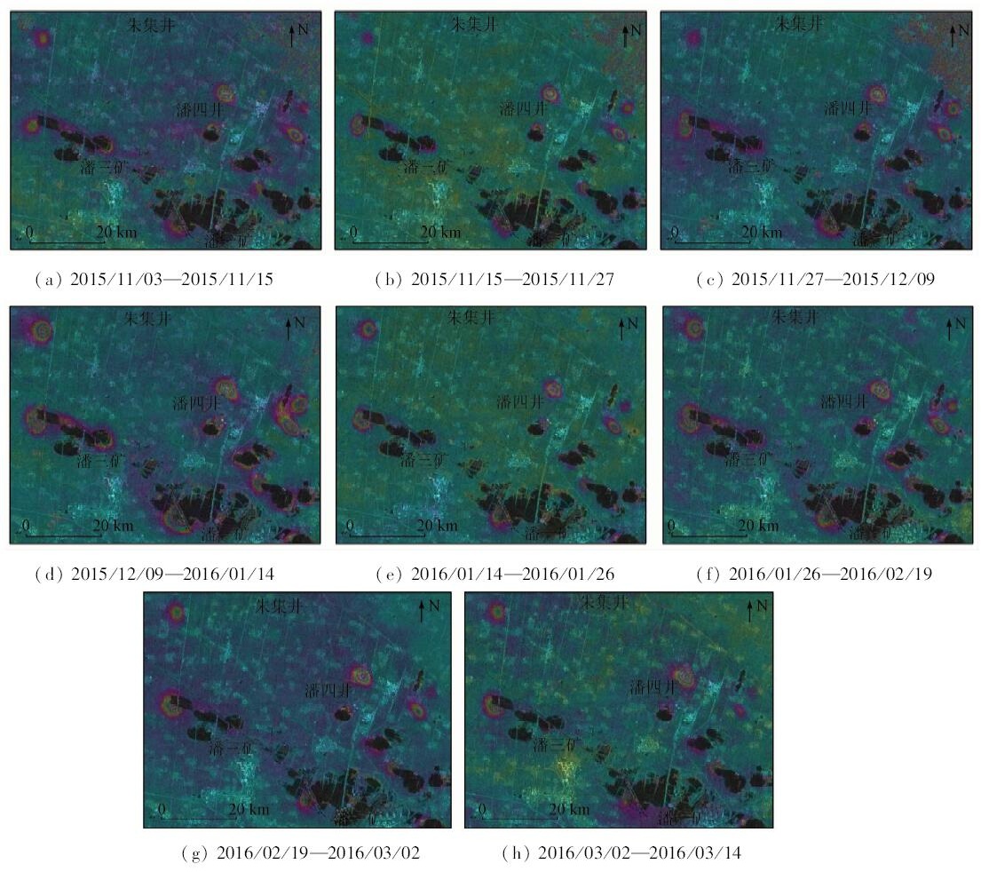
Abstract This paper presents the subsidence results of the Huainan coal mine from Sentinel-1 TOPS images during the period between November 3, 2015 and March 14, 2016 using Stacking technique. The high accuracy coregistration comprising three steps was firstly used to get differential interferograms without phase jump. Then the trend phase was removed by polynomial fitting, and the subsidence rate was retrieved based on the least squares linear regression method. The subsidence velocity map shows that there are several subsidence centers mainly distributed in the west and the north of the research region. The maximum subsidence rate is 80~90 cm/a, and the subsidence is inhomogeneous spatially. The mining subsidence of the study area has the characteristics of high gradients varying from 10 to 80 cm/a, with small subsidence coverage for only 3.13% of the total area. From the differential interferograms the authors found that the deformation magnitude is variable in different observation spans, which implies the nonlinear characteristics of the mine.
|
| Keywords
Sentinel-1
TOPS mode
Stacking technique
Huainan coal mine
ground subsidence
|
|
|
|
Issue Date: 07 December 2018
|
|
|
| [1] |
Nestbitt A. Subsidence monitoring West Cliff Colliery longwall 5A4[C]// Association of Public Authority Surveyors.Wollongong:APAS, 2003: 133-139.
|
| [2] |
李楠, 王磊 . 基于D-InSAR技术的老采空区稳定性监测研究[J]. 矿山测量, 2016,44(3):1-4.
doi: 10.3969/j.issn.1001-358X.2016.03.001
url: http://d.wanfangdata.com.cn/Periodical/kscl201603001
|
| [2] |
Li N, Wang L . Research of coal mining subsidence monitoring based on D-InSAR technology[J]. Mine Surveying, 2016,44(3):1-4.
|
| [3] |
张飞 . 基于DInSAR技术的淮南采煤沉陷区地面沉降监测研究[D]. 南京:南京大学, 2012.
|
| [3] |
Zhang F . Study on DInSAR Technology of Monitoring Land Subsidence in Huainan Mining Area[D]. Nanjing:Nanjing University, 2012.
|
| [4] |
刘文倩 . InSAR测量技术在淮南矿区地面沉降监测中的应用[D]. 合肥:合肥工业大学, 2012.
|
| [4] |
Liu W Q . An Application of InSAR Technology in Ground Subsidence Monitoring in Huainan Coal-mining Area[D]. Hefei:Hefei University of Technology, 2012.
|
| [5] |
Biggs J, Wright T, Lu Z , et al. Multi-interferogram method for measuring interseismic deformation:Denali Fault, Alaska[J]. Geophysical Journal International, 2007,170(3):1165-1179.
doi: 10.1111/j.1365-246X.2007.03415.x
url: http://blackwell-synergy.com/doi/abs/10.1111/gji.2007.170.issue-3
|
| [6] |
Zhao Q, Lin H, Jiang L M. Ground deformation monitoring in Pearl River Delta region with Stacking D-InSAR technique[C]// Proceedings of SPIE,Geoinformatics 2008 and Joint Conference on GIS and Built Environment:Monitoring and Assessment of Natural Resources and Environments. 2008,714513:1-9.
|
| [7] |
Geudtner D, Torres R, Snoeij P, et al. Sentinel-1 system[C]// 2014 10th European Conference on Synthetic Aperture Radar (EUSAR).Berlin:VDE, 2014: 1-3.
|
| [8] |
Berger M, Moreno J, Johannessen J A , et al. ESA’s sentinel missions in support of earth system science[J]. Remote Sensing of Environment, 2012,120:84-90.
doi: 10.1016/j.rse.2011.07.023
url: https://linkinghub.elsevier.com/retrieve/pii/S003442571200065X
|
| [9] |
Zan F D, Guarnieri A M M. TOPSAR:Terrain observation by progressive scans[J]. IEEE Transactions on Geoscience and Remote Sensing, 2006,44(9):2352-2360.
doi: 10.1109/TGRS.2006.873853
url: http://ieeexplore.ieee.org/document/1677745/
|
| [10] |
Gabriel A K, Goldstein R M, Zebker H A . Mapping small elevation changes over large areas:Differential Radar interferometry[J]. Journal of Geophysical Research:Solid Earth, 1989,94(B7):9183-9191.
doi: 10.1029/JB094iB07p09183
url: http://doi.wiley.com/10.1029/JB094iB07p09183
|
| [11] |
Wright T, Parsons B, Fielding E . Measurement of interseismic strain accumulation across the North Anatolian Fault by satellite Radar interferometry[J]. Geophysical Research Letters, 2001,28(10):2117-2120.
doi: 10.1029/2000GL012850
url: http://doi.wiley.com/10.1029/2000GL012850
|
| [12] |
Ferretti A, Prati C, Rocca F . Permanent scatterers in SAR interferometry[J]. IEEE Transactions on Geoscience and Remote Sensing, 2001,39(1):8-20.
doi: 10.1109/36.898661
url: http://ieeexplore.ieee.org/document/898661/
|
| [13] |
Berardino P, Fornaro G, Lanari R , et al. A new algorithm for surface deformation monitoring based on small baseline differential SAR interferograms[J]. IEEE Transactions on Geoscience and Remote Sensing, 2002,40(11):2375-2383.
doi: 10.1109/TGRS.2002.803792
url: http://ieeexplore.ieee.org/document/1166596/
|
| [14] |
Bara M, Scheiber R, Broquetas A , et al. Interferometric SAR signal analysis in the presence of squint[J]. IEEE Transactions on Geoscience and Remote Sensing, 2000,38(5):2164-2178.
doi: 10.1109/36.868875
url: http://ieeexplore.ieee.org/document/868875/
|
| [15] |
Prats P, Marotti L, Wollstadt S. Investigation on TOPS interferometry with TerraSAR-X [C]//2010 IEEE International Geoscience and Remote Sensing Symposium(IGARSS).Honolulu:IEEE, 2010.
|
| [16] |
Scheiber R, Moreira A . Coregistration of interferometric SAR images using spectral diversity[J]. IEEE Transactions on Geoscience and Remote Sensing, 2000,38(5):2179-2191.
doi: 10.1109/36.868876
url: http://ieeexplore.ieee.org/document/868876/
|
| [17] |
Ng A H M, Ge L L, Li X J , et al. Monitoring ground deformation in Beijing,China with persistent scatterer SAR interferometry[J]. Journal of Geodesy, 2012,86(6):375-392.
doi: 10.1007/s00190-011-0525-4
url: http://link.springer.com/10.1007/s00190-011-0525-4
|
| [18] |
闫建伟, 汪云甲, 朱勇 . 基于D-InSAR技术的淮南矿区地面沉陷监测[J]. 工矿自动化, 2011,37(8):48-51.
url: http://www.cqvip.com/QK/95769A/201108/38872513.html
|
| [18] |
Yan J W, Wang Y J, Zhu Y . Monitoring of surface subsidence based on D-InSAR technology in Huainan mining area[J]. Industry and Mine Automation, 2011,37(8):48-51.
|
|
Viewed |
|
|
|
Full text
|
|
|
|
|
Abstract
|
|
|
|
|
Cited |
|
|
|
|
| |
Shared |
|
|
|
|
| |
Discussed |
|
|
|
|
 2018,
Vol. 30
2018,
Vol. 30