|
|
 |
|

|
|
|
Research on applications of InSAR technology to the deformation monitoring of buildings along the subway |
Mao ZHU1, Tiyan SHEN1( ), Song HUANG2, Shujian BAI3, Chunqin GE3, Qiong HU3 ), Song HUANG2, Shujian BAI3, Chunqin GE3, Qiong HU3 |
1.School of Government, Peking University, Beijing 100871, China
2.Shenzhen Urban Public Safety and Technology Institute, Shenzhen 518048, China
3.Beijing Vastitude Technology Co., Ltd., Beijing 100081, China |
|
|
|
|
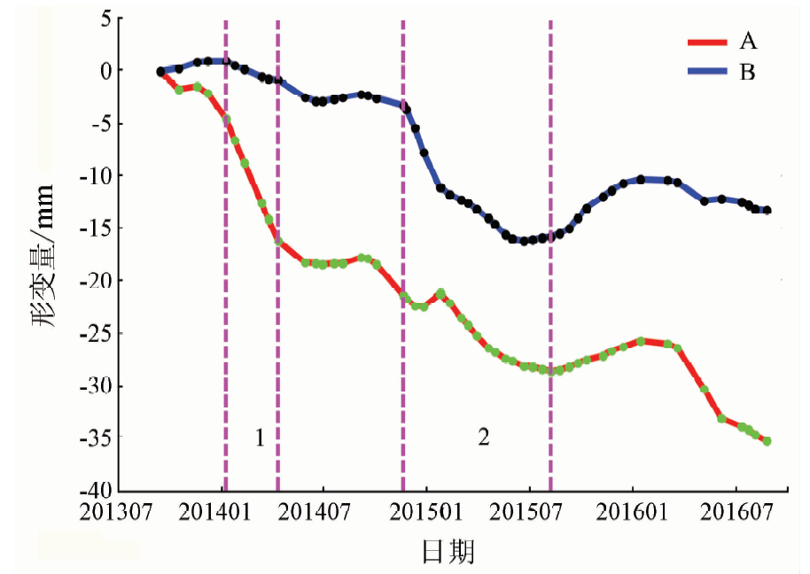
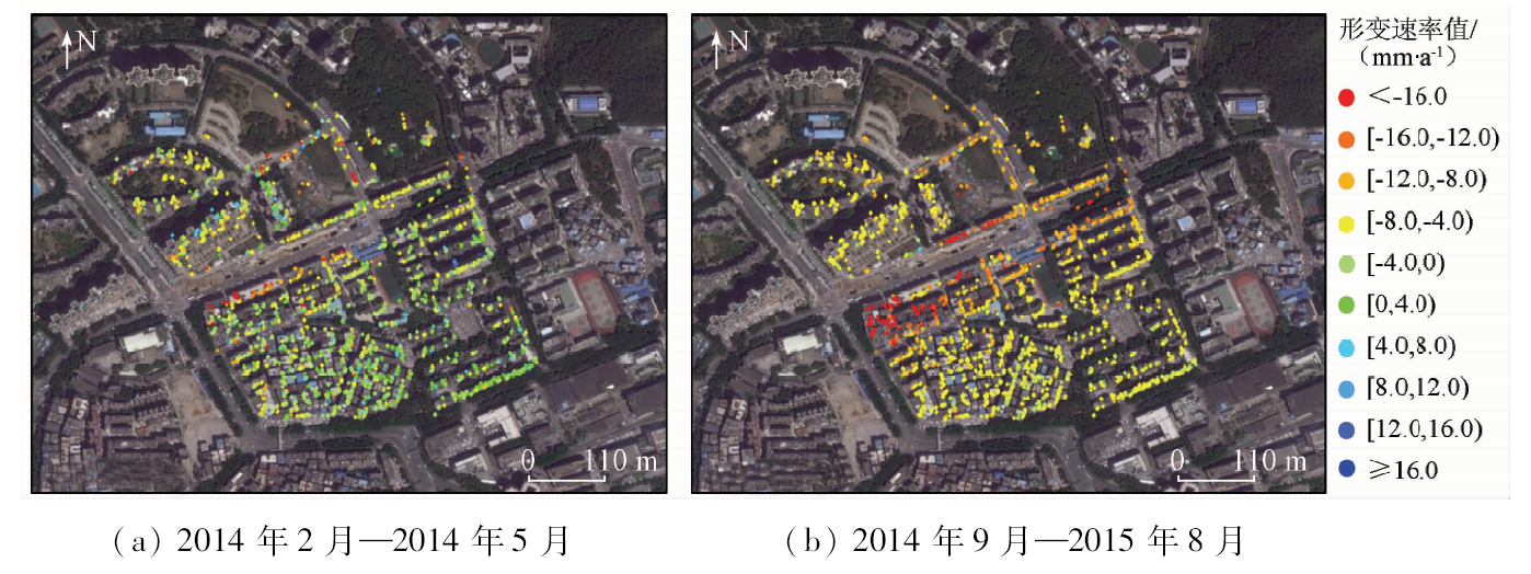
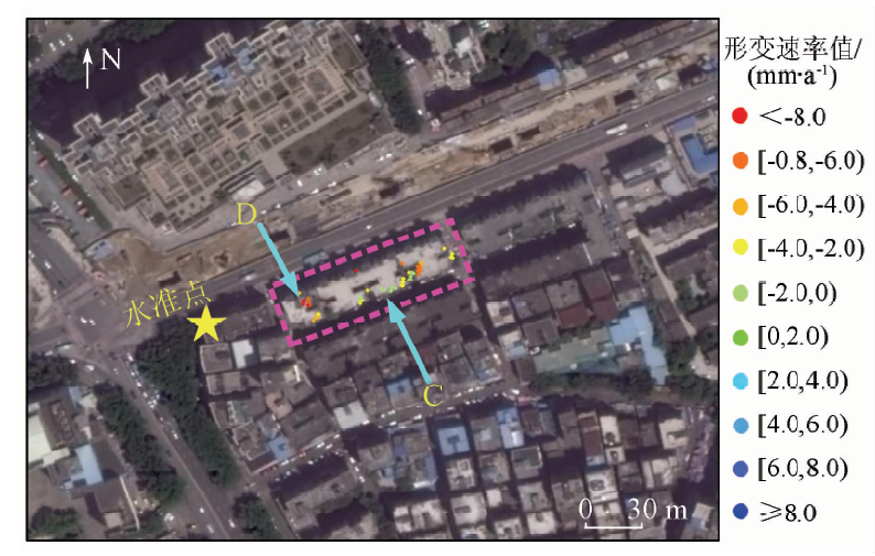
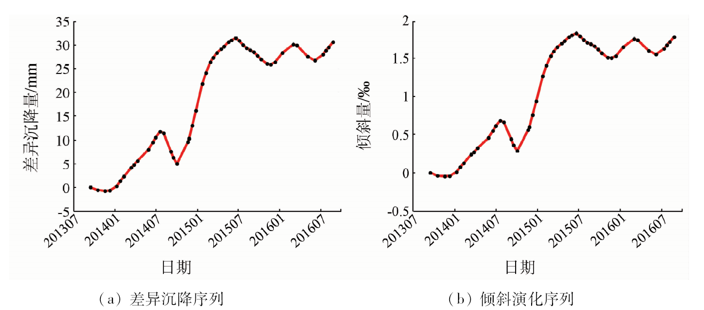
Abstract As a slow onset geological hazard, ground subsidence could damage buildings. In particular, the settlement risk induced by subway construction on building structures has become a matter of concern to governmental authorities and the public. Spaceborne interferometric synthetic aperture Radar (InSAR) technology could acquire high-precision surface deformation information and provide technical support to evaluate the risk level of urban buildings caused by ground subsidence hazards. Based on the deformation data acquired from September 2013 to September 2016 by PSP-InSAR algorithm, the authors selected the buildings near a subway station in Shenzhen as the study object. In data analysis process, first of all, combined with the construction scheme of subway station, geological information and the property of the building, the authors carried out the corresponding research on the change of the deformation trend in different periods and the risk assessment of the settlement disaster. Then, one building in the study area was selected as the research object, and the differential deformation and inclination were analyzed based on the deformation of PS at different locations. Combined with the corresponding standards, the risk of building subsidence disaster was preliminarily evaluated. Finally, by comparing with the leveling data, the precision of the InSAR measurement results was discussed. In accordance with the field investigation, it is verified that the corresponding risk symptoms have been found on the buildings whose deformation values were identified as relatively high in the analysis process. The comparison between data analysis and field investigation results confirms that InSAR technology is capable of playing an important role in urban building risk management process in the future and the methodology can be widely applied beyond the case study area.
|
| Keywords
ground subsidence monitoring
building deformation analysis
InSAR
subway construction monitoring
|
|
|
|
Corresponding Authors:
Tiyan SHEN
E-mail: tyshen@pku.edu.cn
|
|
Issue Date: 23 May 2019
|
|
|
| [1] |
高飞 . 城市地铁隧道施工引起的地面沉降[J].城市建筑, 2016(18):338.
|
| [1] |
Gao F . Ground surface settlement due to urban tunnel construction[J].Urbanism and Architecture, 2016(18):338.
|
| [2] |
Bamler R, Hartl P . Synthetic aperture Radar interferometry[J]. Inverse Problems, 1998,14(4):1-54.
doi: 10.1088/0266-5611/14/1/002
url: http://stacks.iop.org/0266-5611/14/i=1/a=002?key=crossref.b78c3a90a23aafcaa52349dcfaf09f2f
|
| [3] |
廖明生, 王腾 . 时间序列InSAR技术与应用[M]. 北京: 科学出版社, 2014.
|
| [3] |
Liao M S, Wang T. Time Series InSAR Technology and Its Application[M]. Beijing: Science Press, 2014.
|
| [4] |
朱建军, 李志伟, 胡俊 . InSAR变形监测方法与研究进展[J]. 测绘学报, 2017,46(10):1717-1733.
|
| [4] |
Zhu J J, Li Z W, Hu J . Research progress and methods of InSAR for deformation monitoring[J]. Acta Geodaetica et Cartographica Sinica, 2017,46(10):1717-1733.
|
| [5] |
葛大庆, 殷跃平, 王艳 , 等. 地面沉降-回弹及地下水位波动的InSAR长时序监测——以德州市为例[J]. 国土资源遥感, 2014,26(1):103-109.doi: 10.6046/gtzyyg.2014.01.18.
doi: 10.6046/gtzyyg.2014.01.18
|
| [5] |
Ge D Q, Yin Y P, Wang Y , et al. Seasonal subsidence-rebound and ground water level changes monitoring by using coherent target InSAR technique:A case study of Dezhou,Shandong[J]. Remote Sensing for Land and Resources, 2014,26(1):103-109.doi: 10.6046/gtzyyg.2014.01.18.
|
| [6] |
刘一霖, 张勤, 黄海军 , 等. 矿区地表大量级沉陷形变短基线集InSAR监测分析[J]. 国土资源遥感, 2017,29(2):144-151.doi: 10.6046/gtzyyg.2017.02.21.
|
| [6] |
Liu Y L, Zhang Q, Huang H J , et al. Monitoring and analyzing large scale land subsidence over the mining area using small baseline subset InSAR[J]. Remote Sensing for Land and Resources, 2017,29(2):144-151.doi: 10.6046/gtzyyg.2017.02.21.
|
| [7] |
赵亿, 钱乐, 杨魁 . 探讨InSAR技术在城市建筑物沉降监测中的精度[J].城市勘测, 2015(3):115-119.
|
| [7] |
Zhao Y, Qian L, Yang K . The discussion of InSAR accuracy in the urban building subsidence monitoring[J].Urban Geotechnical Investigation and Surveying, 2015(3):115-119.
|
| [8] |
Gernhardt S, Bamler R . Deformation monitoring of single buildings using meter-resolution SAR data in PSI[J]. ISPRS Journal of Photogrammetry and Remote Sensing, 2012,73(9):68-79.
doi: 10.1016/j.isprsjprs.2012.06.009
url: https://linkinghub.elsevier.com/retrieve/pii/S0924271612001232
|
| [9] |
Bianchini S, Pratesi F, Nolesini T , et al. Building deformation assessment by means of persistent scatterer interferometry analysis on a landslide-affected area:The Volterra (Italy) case study[J]. Remote Sensing, 2015,7(4):4678-4701.
doi: 10.3390/rs70404678
url: http://www.mdpi.com/2072-4292/7/4/4678
|
| [10] |
Tapete D, Fanti R, Cecchi R , et al. Satellite Radar interferometry for monitoring and early-stage warning of structural instability in archaeological sites[J]. Journal of Geophysics and Engineering, 2012,9(4):10-25.
doi: 10.1088/1742-2132/9/4/S10
url: https://academic.oup.com/jge/article/9/4/S10-S25/5127623
|
| [11] |
陈蓓蓓, 宫辉力, 李小娟 , 等. 基于InSAR技术北京地区地面沉降监测与风险分析[J]. 地理与地理信息科学, 2011,27(2):16-20.
|
| [11] |
Chen P P, Gong H L, Li X J , et al. Monitoring and risk analysis of land subsidence in Beijing based on interferometric synthetic aperture Radar(InSAR) technique[J]. Geography and Geo-Information Science, 2011,27(2):16-20.
|
| [12] |
秦晓琼, 廖明生, 杨梦诗 , 等. 应用高分辨率PS-InSAR技术监测上海动迁房歪斜形变[J].测绘通报, 2016(6):18-21.
|
| [12] |
Qing X Q, Liao M S, Yang M S , et al. Monitoring Shanghai relocation housing skew deformation using high resolution PS-InSAR technolo-gy[J].Bulletin of Surveying and Mapping, 2016(6):18-21.
|
| [13] |
Costantini M, Falco S, Malvarosa F, et al. A new method for identification and analysis of persistent scatterers in series of SAR images [C]//IEEE International Geoscience and Remote Sensing Symposium (IGARSS).Boston:IEEE, 2008: 449-452.
|
| [14] |
Costantini M, Falco S, Malvarosa F , et al. Persistent scatterer pair interferometry:Approach and application to COSMO-SkyMed SAR data[J]. IEEE Journal of Selected Topics in Applied Earth Observations and Remote Sensing, 2014,7(7):2869-2879.
doi: 10.1109/JSTARS.2014.2343915
url: http://ieeexplore.ieee.org/document/6881816/
|
| [15] |
Ferretti A, Prati C, Rocca F . Nonlinear subsidence rate estimation using permanent scatterers in differential SAR interferometry[J]. IEEE Transactions on Geoscience and Remote Sensing, 2000,38(5):2202-2212.
doi: 10.1109/36.868878
url: http://ieeexplore.ieee.org/document/868878/
|
| [16] |
Ferretti A, Prati C, Rocca F . Permanent scatterers in SAR interfero-metry[J]. IEEE Transactions on Geoscience and Remote Sensing, 2001,39(1):8-20.
doi: 10.1109/36.898661
url: http://ieeexplore.ieee.org/document/898661/
|
| [17] |
Covello F.Battazza F.Coletta A , et al. COSMO-SkyMed an existing opportunity for observing the Earth[J]. Journal of Geodynamics, 2010,49(3-4):171-180.
doi: 10.1016/j.jog.2010.01.001
url: https://linkinghub.elsevier.com/retrieve/pii/S0264370710000050
|
|
Viewed |
|
|
|
Full text
|
|
|
|
|
Abstract
|
|
|
|
|
Cited |
|
|
|
|
| |
Shared |
|
|
|
|
| |
Discussed |
|
|
|
|
 2019,
Vol. 31
2019,
Vol. 31