|
|
 |
|

|
|
|
Optimal scale selection for multi-scale segmentation based on RMNE method |
| Ning MAO1,2, Huiping LIU1,2, Xiangping LIU1,2, Yanghua ZHANG1,2 |
1.Beijing Key Laboratory of Environmental Remote Sensing and Digital Cities, Beijing Normal University, Beijing 100875, China
2.School of Geography, Faculty of Geographical Science, Beijing Normal University, Beijing 100875, China |
|
|
|
|
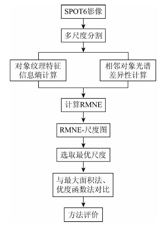
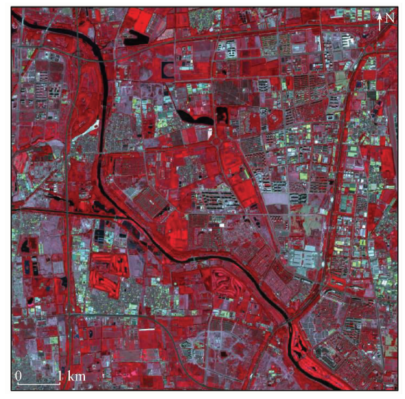
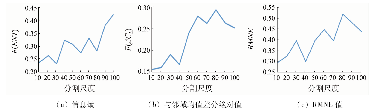
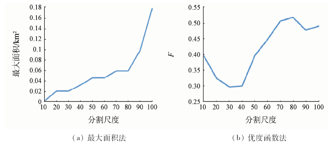
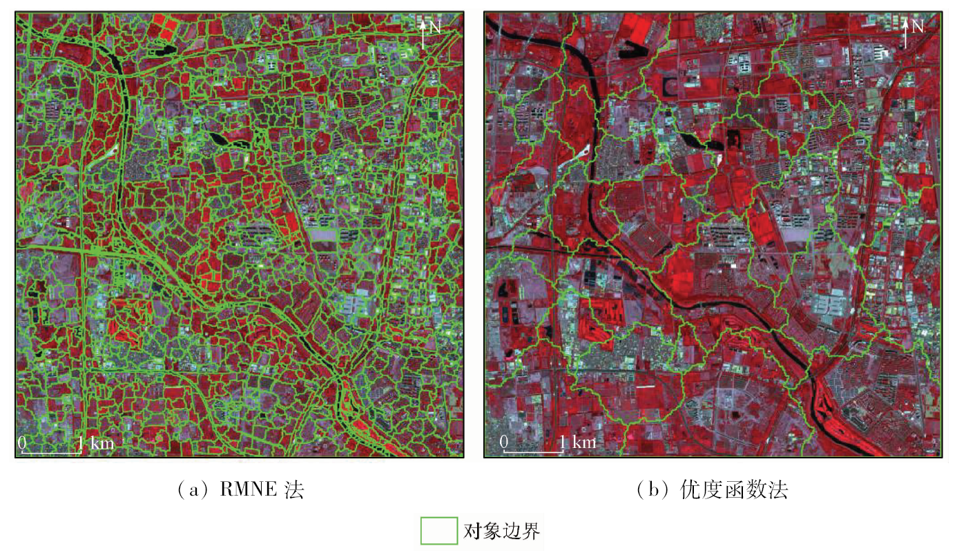
Abstract Multi-scale segmentation is one of the most important methods in object oriented information extraction, and the selection of optimal segmentation scale is a hot topic. Nevertheless, existing optimal segmentation scale selection methods only use spectral characteristics. In view of such a situation, this paper proposes a RMNE method, which uses textural information entropy to measure the heterogeneity between objects, uses spectral characteristics mean difference to neighborhoods to measure the object’s internal homogeneity and construct the evaluation function, and selects the optimal segmentation scales by drawing function curve. Taking 6 m spatial resolution multi-spectral SPOT6 image of the periphery of Beijing City as the multi-scale segmentation experiment example, the authors detected that the optimal scales combination is 30, 60 and 80. Compared with the multi-scale segmentation results whose optimal scales are obtained by the maximum area method and objective function method, it is shown that the effect of RMNE method is the best, which verifies the validity of the RMNE method and the applicability of the high resolution image. A comparison with Google Earth image shows that the image object’s size obtained by RMNE method is most consistent with that of the actual ground object.
|
| Keywords
object oriented
multi-scale segmentation
RMNE
optimal segmentation scale
entropy of information
SPOT6
|
|
|
|
Issue Date: 23 May 2019
|
|
|
| [1] |
Hall O, Hay G J . A multiscale object-specific approach to digital change detection[J]. International Journal of Applied Earth Observation and Geoinformation, 2003,4(4):311-327.
doi: 10.1016/S0303-2434(03)00010-2
url: https://linkinghub.elsevier.com/retrieve/pii/S0303243403000102
|
| [2] |
Espindola G M, Camara G, Reis I A , et al. Parameter selection for region-growing image segmentation algorithms using spatial autocorrelation[J]. International Journal of Remote Sensing, 2006,27(14):3035-3040.
doi: 10.1080/01431160600617194
url: https://www.tandfonline.com/doi/full/10.1080/01431160600617194
|
| [3] |
Woodcock C E, Strahler A H . The factor of scale in remote sensing[J]. Remote Sensing of Environment, 1987,21(3):311-332.
doi: 10.1016/0034-4257(87)90015-0
url: https://linkinghub.elsevier.com/retrieve/pii/0034425787900150
|
| [4] |
张俊, 朱国龙, 李妍 . 面向对象高分辨率影像信息提取中的尺度效应及最优尺度研究[J]. 测绘科学, 2011,36(2):107-109.
url: http://d.wanfangdata.com.cn/Periodical/chkx201102035
|
| [4] |
Zhang J, Zhu G L, Li Y . Scale effect and optimal scale in object-oriented information extraction of high spatial resolution remote sensing image[J]. Science of Surveying and Mapping, 2011,36(2):107-109.
|
| [5] |
黄慧萍, 吴炳方 . 地物大小、对象尺度、影像分辨率的关系分析[J]. 遥感技术与应用, 2006,21(3):243-248.
doi: 10.3969/j.issn.1004-0323.2006.03.013
url: http://d.wanfangdata.com.cn/Periodical/ygjsyyy200603013
|
| [5] |
Huang H P, Wu B F . Analysis to the relationship of feature size,objects scales,image resolution[J]. Remote Sensing Technology and Application, 2006,21(3):243-248.
|
| [6] |
佃袁勇, 方圣辉, 姚崇怀 . 多尺度分割的高分辨率遥感影像变化检测[J]. 遥感学报, 2016,20(1):129-137.
doi: 10.11834/jrs.20165074
url: http://www.cnki.com.cn/Article/CJFDTotal-YGXB201601013.htm
|
| [6] |
Dian Y Y, Fang S H, Yao C H . Change detection for high-resolution images using multilevel segment method[J]. Journal of Remote Sensing, 2016,20(1):129-137.
|
| [7] |
袁秀华, 罗卫, 王聪颖 . 赣州稀土矿山高分辨率遥感影像分割的最优尺度选取[J].测绘与空间地理信息, 2013(9):48-50.
doi: 10.3969/j.issn.1672-5867.2013.09.013
url: http://d.wanfangdata.com.cn/Periodical/dbch201309013
|
| [7] |
Yuan X H, Luo W, Wang C Y . Optimal scale selection research of high-resolution remote sensing images of rare earth mine in Ganzhou[J].Geomatics and Spatial Information Technology, 2013(9):48-50.
|
| [8] |
Liang K, Tjahjadi T . Adaptive scale fixing for multiscale texture segmentation[J]. IEEE Transactions on Image Processing, 2006,15(1):249-256.
doi: 10.1109/TIP.2005.860340
pmid: 16435554
url: http://ieeexplore.ieee.org/lpdocs/epic03/wrapper.htm?arnumber=1556642
|
| [9] |
Coburn C A , Roberts A C B .A multiscale texture analysis procedure for improved forest stand classification[J]. International Journal of Remote Sensing, 2004,25(20):4287-4308.
doi: 10.1080/0143116042000192367
url: https://www.tandfonline.com/doi/full/10.1080/0143116042000192367
|
| [10] |
Kim M, Warner T A, Madden M , et al. Multi-scale GEOBIA with very high spatial resolution digital aerial imagery:Scale,texture and image objects[J]. International Journal of Remote Sensing, 2011,32(10):2825-2850.
doi: 10.1080/01431161003745608
url: https://www.tandfonline.com/doi/full/10.1080/01431161003745608
|
| [11] |
林雪, 彭道黎, 黄国胜 , 等. 结合多尺度纹理特征的遥感影像面向对象分类[J]. 测绘工程, 2016,25(7):22-27.
doi: 10.19349/j.cnki.issn1006-7949.2016.07.005
url: http://www.cqvip.com/QK/98521X/201607/669466684.html
|
| [11] |
Lin X, Peng D L, Huang G S , et al. Object-oriented classification with multi scale texture feature based on remote sensing image[J]. Engineering of Surveying and Mapping, 2016,25(7):22-27.
|
| [12] |
Wang J L, Han Y, Zhao S S , et al. A new multi-scale analytic algorithm for edge extraction of strawberry leaf images in natural light[J]. International Journal of Agriculturaland Biological Engineering, 2016,9(1):99-108.
url: http://www.cabdirect.org/abstracts/20163181935.html
|
| [13] |
李晓靖, 彭道黎, 王海宾 . 基于最优尺度和规则的高分辨率影像分类研究[J]. 测绘工程, 2017,26(9):14-22.
url: http://d.wanfangdata.com.cn/Periodical/chgc201709004
|
| [13] |
Lin X J, Peng D L, Wang H B . Classification of high-resolution image based on optimal scale and rule[J]. Engineering of Surveying and Mapping, 2017,26(9):14-22.
|
| [14] |
杨海平, 明冬萍 . 综合多层优选尺度的高分辨率影像分割[J]. 地球信息科学学报, 2016,18(5):632-638.
doi: 10.3724/SP.J.1047.2016.00632
url: http://d.wanfangdata.com.cn/Periodical/dqxxkx201605008
|
| [14] |
Yang H P, Ming D P . Optimal scales based segmentation of high spatial resolution remote sensing data[J]. Journal of Geo-Information Science, 2016,18(5):632-638.
|
| [15] |
Malik J, Belongie S, Leung T , et al. Contour and texture analysis for image segmentation[J]. International Journal of Computer Vision, 2001,43(1):7-27.
doi: 10.1023/A:1011174803800
url: http://link.springer.com/10.1023/A:1011174803800
|
|
Viewed |
|
|
|
Full text
|
|
|
|
|
Abstract
|
|
|
|
|
Cited |
|
|
|
|
| |
Shared |
|
|
|
|
| |
Discussed |
|
|
|
|
 2019,
Vol. 31
2019,
Vol. 31