|
|
 |
|

|
|
|
Exploring the monitoring technology for Huanglongbing at the plot scale under satellite-ground collaboration |
XIE Guoxue1( ), HUANG Qiting1, YANG Shaoe1, LIANG Yongjian2, QIN Zelin1(), SU Qiuqun1 ), HUANG Qiting1, YANG Shaoe1, LIANG Yongjian2, QIN Zelin1(), SU Qiuqun1 |
1. Agricultural Science and Technology Information Research Institute, Guangxi Academy of Agricultural Sciences, Nanning 530007, China
2. Guangxi South Subtropical Agricultural Science Research Institute, Chongzuo 532415, China |
|
|
|
|
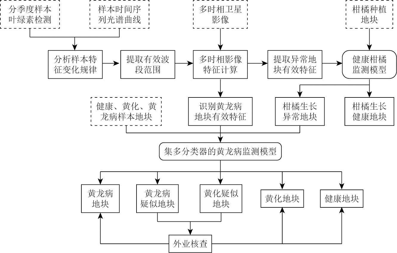
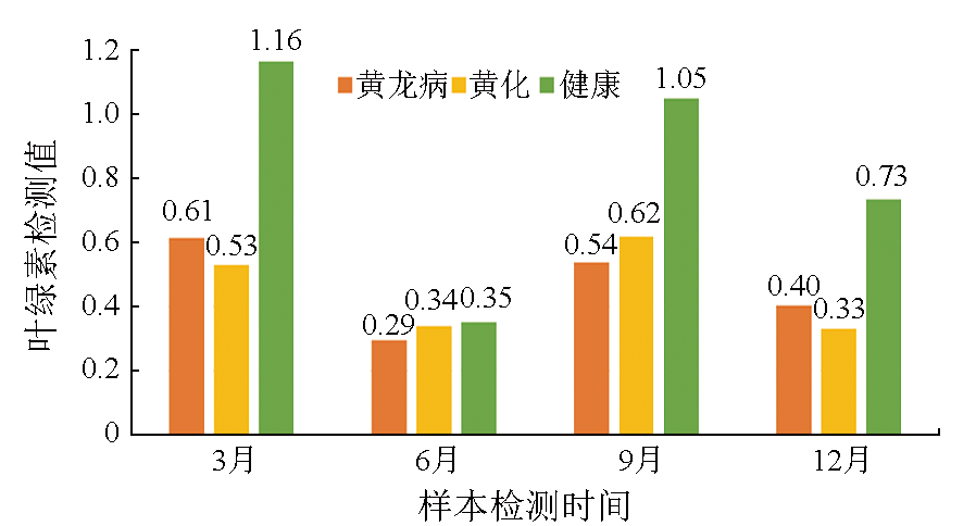
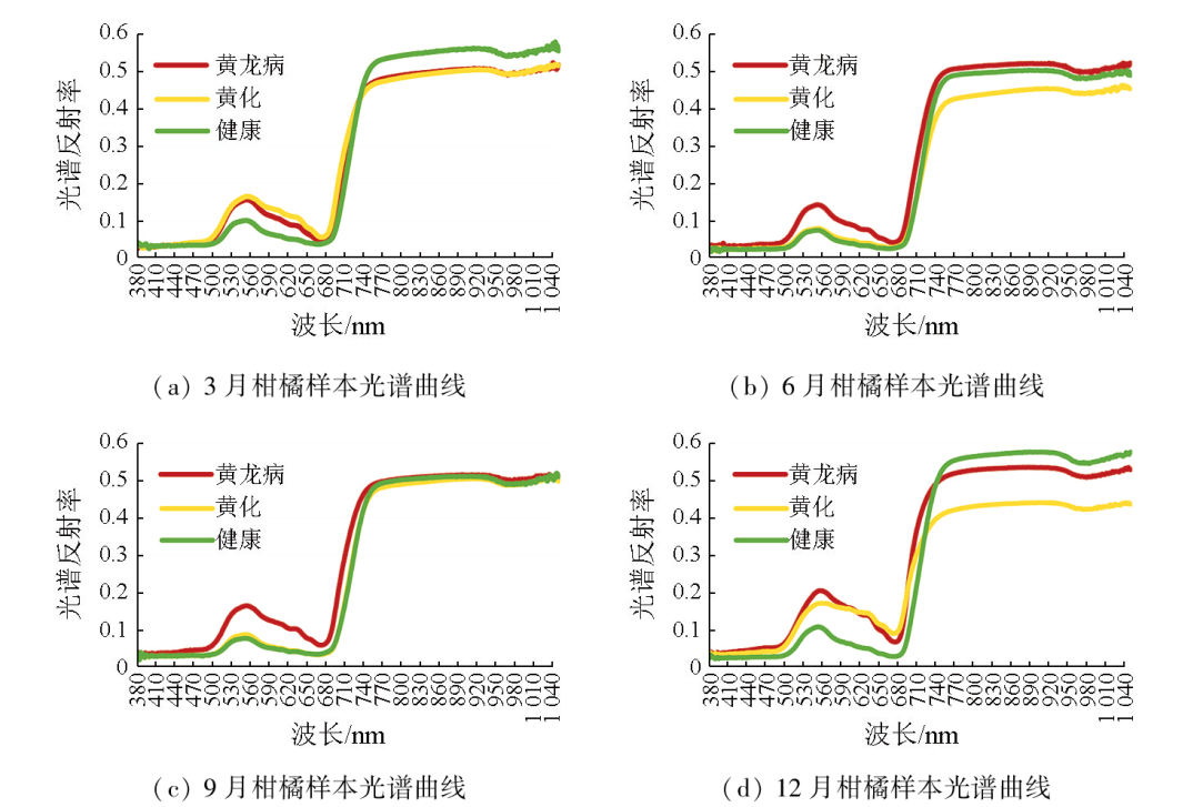
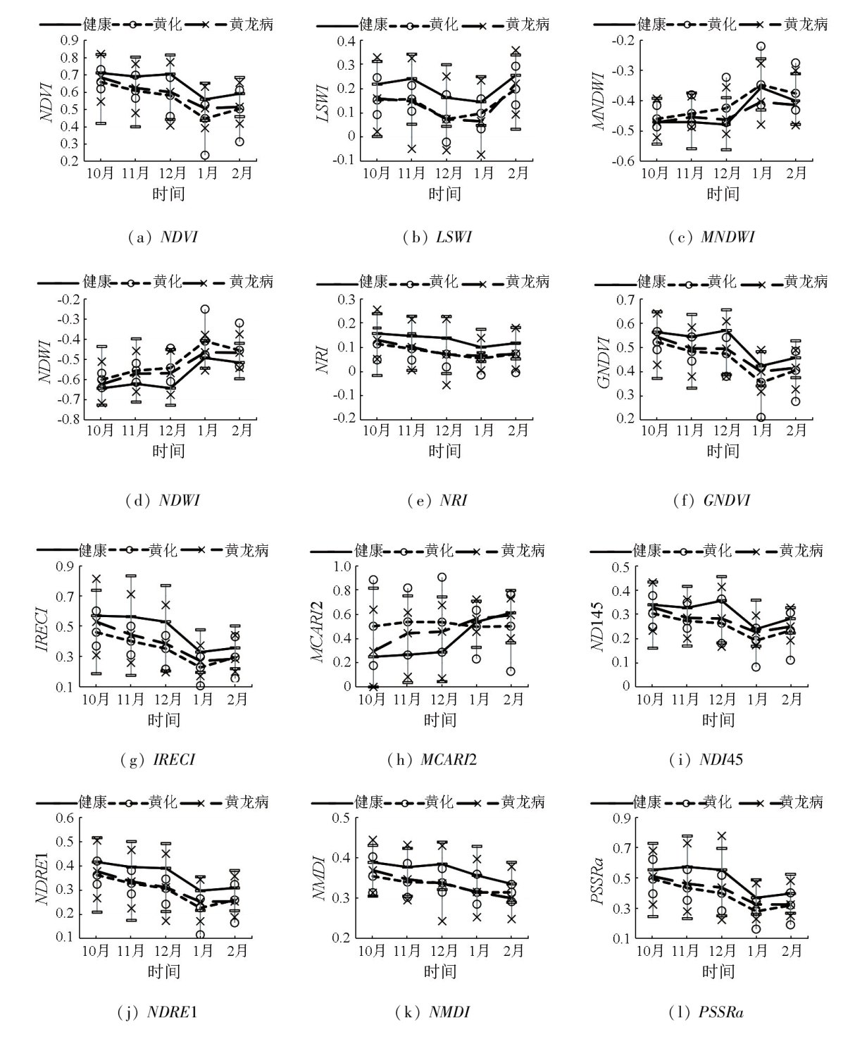
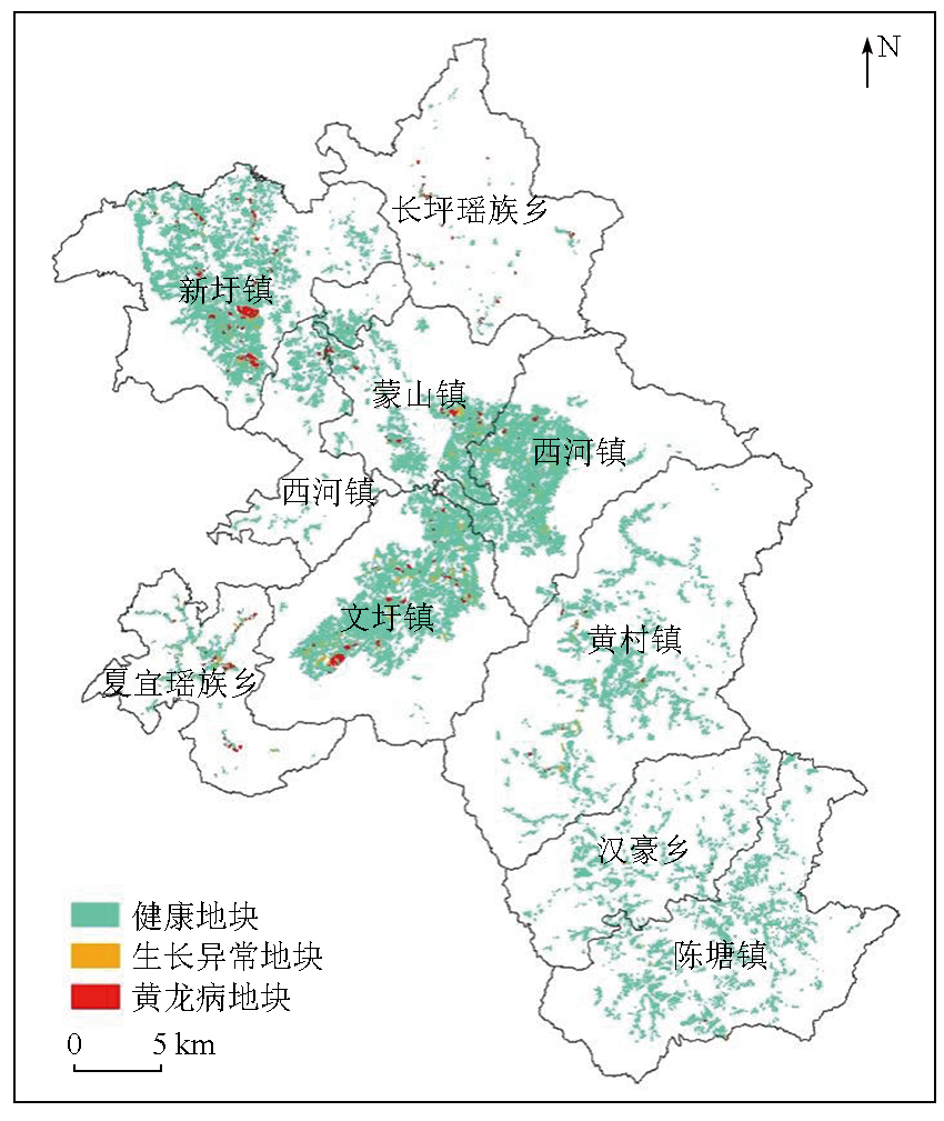
Abstract To efficiently monitor citrus greening (also called Huanglongbing in Chinese) at the large plot scale, this study investigated the healthy, yellowing, and Huanglongbing-affected citrus leaves sampled quarterly from the ground in Mengshan County in Guangxi Province. By performing polymerase chain reaction (PCR), chlorophyll content, and hyperspectral detections on these leaf samples, this study analyzed the variation patterns of citrus characteristics under different states, extracting the effective bands and image features for Huanglongbing monitoring. Furthermore, this study constructed a monitoring model for healthy citrus to reduce the objects to be discriminated and identify abnormal citrus growth plots. Finally, this study extracted the Huanglongbing-affected plots using a multi-classifier algorithm based on the effective features from multitemporal Sentinel-2 images. The results of this study indicate that the Huanglongbing-affected and yellowing leaf samples yielded highly similar chlorophyll contents. In March and December, the Huanglongbing-affected citrus exhibited higher chlorophyll content compared to the yellowing citrus. However, the case was the opposite in June and September. The hyperspectral curves suggest that December is a significant period for identifying Huanglongbing and yellowing. The wavelengths ranging from 530 nm to 650 nm and 740 nm to 1050 nm proved effective for diagnosing Huanglongbing and yellowing. The feature indices based on the Sentinel-2 image for December, including the normalized difference vegetation index (NDVI), land surface water index (LSWI), nitrogen reflectance index (NRI), green normalized difference vegetation index (GNDVI), and inverted red edge chlorophyll index (IRECI), could effectively distinguish between healthy and abnormal growth plots of citrus. The feature indices based on the Sentinel-2 images covering periods from October to December and January to February of the following year, including the NDVI, modified normalized difference water index (MNDWI), normalized difference water index (NDWI), GNDVI, inverted red-edge chlorophyll index (IRECI), modified chlorophyll absorption ratio index 2 (MCARI2), normalized difference index based on Landsat bands 4 and 5 (NDI45), and pigment specific simple ratio chlorophyll index (PSSRa), showed advantages in monitoring Huanglongbing. The identification accuracy of Huanglongbing-affected plots in Mengshan County was 86.6 %, with a missed detection rate of 7.8 % and an error rate of 10.4 %. In 2021, Mengshan County held 964 Huanglongbing-affected plots covering an area of 220.13 hm2, with an incidence rate of 2.02 % for large-scale Huanglongbing, mainly concentrated in Xinxu, Wenxu, and Mengshan towns, and Xiayi Yao Township. The combination of satellite remote sensing and ground measurement enables large-scale monitoring of Huanglongbing-affected plots. The monitoring technology in this study provides novel insights for the large-scale monitoring, prevention, and control of Huanglongbing.
|
| Keywords
satellite remote sensing
ground measurement
plot scale
Huanglongbing
monitoring technology
|
|
|
|
Issue Date: 09 May 2025
|
|
|
| [1] |
谢国雪, 黄启厅, 杨绍锷, 等. 基于中高分影像的丘陵区柑橘种植地块提取[J]. 南方农业学报, 2021, 52(12):3454-3462.
|
| [1] |
Xie G X, Huang Q T, Yang S E, et al. Extraction of citrus planting plots based on medium-high different images[J]. Journal of Southern Agriculture, 2021, 52(12):3454-3462.
|
| [2] |
白先进, 赵小龙, 娄兵海, 等. 回顾广西柑橘黄龙病防控(1982-2020)[J]. 南方园艺, 2020, 31(6):5-16.
|
| [2] |
Bai X J, Zhao X L, Lou B H, et al. A review of citrus Huanglongbing control in Guangxi from 1982 to 2020[J]. Southern Horticulture, 2020, 31(6):5-16.
|
| [3] |
鹿连明, 范国成, 胡秀荣, 等. 田间柑橘植株不同部位黄龙病菌的PCR检测及发病原因分析[J]. 植物保护, 2011, 37(2):45-49.
|
| [3] |
Lu L M, Fan G C, Hu X R, et al. PCR detection of huanglongbing pathogen in different parts of citrus plants in the field and analysis of the cause of the disease[J]. Plant Protection, 2011, 37(2):45-49.
|
| [4] |
翁海勇, 何城城, 许金钗, 等. 叶绿素荧光成像技术下的柑橘黄龙病快速诊断[J]. 农业工程学报, 2020, 36(12):196-203.
|
| [4] |
Weng H Y, He C C, Xu J C, et al. Rapid detection of citrus Huanglongbing based on chlorophyll fluorescence imaging technology[J]. Transactions of the Chinese Society of Agricultural Engineering, 2020, 36(12):196-203.
|
| [5] |
柏自琴, 周常勇. 柑橘黄龙病病原分化及发生规律研究进展[J]. 中国农学通报, 2012, 28(1):133-137.
|
| [5] |
Bai Z Q, Zhou C Y. The research progress of Citrus huanglongbing on pathogen diversity and epidemiology[J]. Chinese Agricultural Science Bulletin, 2012, 28(1):133-137.
|
| [6] |
余继华, 汪恩国, 杨晓, 等. 柑橘黄龙病老龄果园发病力与时序发生规律研究[J]. 农学学报, 2017, 7(4):10-14.
doi: 10.11923/j.issn.2095-4050.cjas16120026
|
| [6] |
Yu J H, Wang E G, Yang X, et al. Citrus liberobacter asiaticum morbidity and timing patterns in old orchards[J]. Journal of Agriculture, 2017, 7(4):10-14.
doi: 10.11923/j.issn.2095-4050.cjas16120026
|
| [7] |
Li X, Lee W S, Li M, et al. Spectral difference analysis and airborne imaging classification for citrus greening infected trees[J]. Computers and Electronics in Agriculture, 2012, 83:32-46.
|
| [8] |
梅慧兰, 邓小玲, 洪添胜, 等. 柑橘黄龙病高光谱早期鉴别及病情分级[J]. 农业工程学报, 2014, 30(9):140-147.
|
| [8] |
Mei H L, Deng X L, Hong T S, et al. Early detection and grading of citrus huanglongbing using hyperspectral imaging technique[J]. Transactions of the Chinese Society of Agricultural Engineering, 2014, 30(9):140-147.
|
| [9] |
Weng H, Lyu J, Cen H, et al. Hyperspectral reflectance imaging combined with carbohydrate metabolism analysis for diagnosis of citrus Huanglongbing in different seasons and cultivars[J]. Sensors and Actuators B:Chemical, 2018, 275:50-60.
|
| [10] |
兰玉彬, 朱梓豪, 邓小玲, 等. 基于无人机高光谱遥感的柑橘黄龙病植株的监测与分类[J]. 农业工程学报, 2019, 35(3):92-100.
|
| [10] |
Lan Y B, Zhu Z H, Deng X L, et al. Monitoring and classification of citrus Huanglongbing based on UAV hyperspectral remote sensing[J]. Transactions of the Chinese Society of Agricultural Engineering, 2019, 35(3):92-100.
|
| [11] |
黄梓效. 基于地-空多源遥感的柑橘黄龙病智能识别技术的研究[D]. 广州: 华南农业大学, 2020.
|
| [11] |
Huang Z X. Research on intelligent recognition technology of citrus Huanglongbing based on ground-air multi-source remote sensing[D]. Guangzhou: South China Agricultural University, 2020.
|
| [12] |
Xu F, Hao Z, Huang L, et al. Comparative identification of citrus huanglongbing by analyzing leaves using laser-induced breakdown spectroscopy and near-infrared spectroscopy[J]. Applied Physics B, 2020, 126(3):43.
|
| [13] |
何城城. 波谱成像技术下的柑橘黄龙病快速检测方法及设备研发[D]. 福州: 福建农林大学, 2022.
|
| [13] |
He C C. Rapid detection citrus HLB by developing a handheld device based on spectral imaging technology[D]. Fuzhou: Fujian Agriculture and Forestry University, 2022.
|
| [14] |
范世达, 马伟荣, 姜文博, 等. 基于深度学习的柑橘黄龙病远程诊断技术初探[J]. 中国果树, 2022(4):76-79,86,133.
|
| [14] |
Fan S D, Ma W R, Jiang W B, et al. Preliminary study on remote diagnosis technology of Citrus Huanglongbing based on deep learning[J]. China Fruits, 2022(4):76-79,86,133.
|
| [15] |
谢国雪, 黄启厅, 杨绍锷, 等. 基于遥感影像的丘陵区柑橘种植地块监测方法及系统:中国,CN111709379B[P]. 2023-04-18.
|
| [15] |
Xie G, Huang Q, Shao E Y. Hilly area citrus planting plot monitoring method and system based on remote sensing images:China,CN111709379B[P]. 2023-04-18.
|
| [16] |
梁锦涛, 陈超, 张自力, 等. 一种融合指数与主成分分量的随机森林遥感图像分类方法[J]. 自然资源遥感, 2023, 35 (3):35-42.doi:10.6046/zrzyyg.2022493.
|
| [16] |
Liang J T, Chen C, Zhang Z L, et al. A random forest-based method integrating indices and principal components for classifying remote sensing images[J]. Remote Sensing for Natural Resources, 2023, 35 (3):35-42.doi:10.6046/zrzyyg.2022493.
|
| [17] |
Jordan C F. Derivation of leaf-area index from quality of light on the forest floor[J]. Ecology, 1969, 50(4):663-666.
|
| [18] |
徐涵秋. 利用改进的归一化差异水体指数(MNDWI)提取水体信息的研究[J]. 遥感学报, 2005, 9(5):589-595.
|
| [18] |
Xu H Q. A study on information extraction of water body with the modified normalized difference water index (MNDWI)[J]. Journal of Remote Sensing, 2005, 9(5):589-595.
|
| [19] |
Tucker C J. Red and photographic infrared linear combinations for monitoring vegetation[J]. Remote Sensing of Environment, 1979, 8(2):127-150.
|
| [20] |
刘伟, 杨共强, 徐飞, 等. 近地高光谱和低空航拍数字图像遥感监测小麦条锈病的比较研究[J]. 植物病理学报, 2018, 48(2):223-227.
doi: 10.13926/j.cnki.apps.000170
|
| [20] |
Liu W, Yang G Q, Xu F, et al. Comparisons of detection of wheat stripe rust using hyper-spectrometer and UAV aerial photography[J]. Acta Phytopathologica Sinica, 2018, 48(2):223-227.
doi: 10.13926/j.cnki.apps.000170
|
| [21] |
Guyot G, Baret F. Utilisation de la haute resolution spectrale pour suivre L'etat des couverts vegetaux[C]// French National Institute for Agriculture,Food,and Environment (INRAE).Proceedings of the 4th International Colloquium on Spectral Signatures of Objects in Remote Sensing, 1988,279-286.
|
| [22] |
Wu C, Niu Z, Tang Q, et al. Estimating chlorophyll content from hyperspectral vegetation indices:Modeling and validation[J]. Agricultural and Forest Meteorology, 2008, 148(8/9):1230-1241.
|
| [23] |
Delegido J, Verrelst J, Alonso L, et al. Evaluation of Sentinel-2 red-edge bands for empirical estimation of green LAI and chlorophyll content[J]. Sensors, 2011, 11(7):7063-7081.
doi: 10.3390/s110707063
pmid: 22164004
|
| [24] |
Gitelson A, Merzlyak M N. Spectral reflectance changes associated with autumn senescence of Aesculus hippocastanum L.and Acer platanoides L.leaves.spectral features and relation to chlorophyll estimation[J]. Journal of Plant Physiology, 1994, 143(3):286-292.
|
| [25] |
张红卫, 陈怀亮, 周官辉, 等. 归一化多波段干旱指数在农田干旱监测中的应用[J]. 科技导报, 2009, 27(11):23-26.
|
| [25] |
Zhang H W, Chen H L, Zhou G H, et al. Application of normalized multiband drought index method in cropland drought monitoring[J]. Science & Technology Review, 2009, 27(11):23-26.
|
| [26] |
Blackburn G A. Quantifying chlorophylls and caroteniods at leaf and canopy scales[J]. Remote Sensing of Environment, 1998, 66(3):273-285.
|
|
Viewed |
|
|
|
Full text
|
|
|
|
|
Abstract
|
|
|
|
|
Cited |
|
|
|
|
| |
Shared |
|
|
|
|
| |
Discussed |
|
|
|
|
 2025,
Vol. 37
2025,
Vol. 37