|
|
 |
|

|
|
|
Predicting surface subsidence in large-scale mining areas based on time-series InSAR and the IRIME-LSTM model |
CEHN Lanlan1( ), FAN Yongchao2, XIAO Haiping3(), WAN Junhui3, CHEN Lei3 ), FAN Yongchao2, XIAO Haiping3(), WAN Junhui3, CHEN Lei3 |
1. School of Resources and Civil Engineering, Gannan University of Science and Technology, Ganzhou 341000, China
2. Jiangxi Piaotang Tungsten Industry Co., Ltd., Ganzhou 341500, China
3. School of Civil Engineering and Surveying and Mapping Engineering, Jiangxi University of Science and Technology, Ganzhou 341000, China |
|
|
|
|
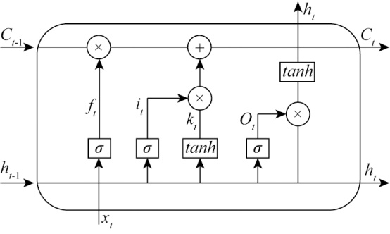
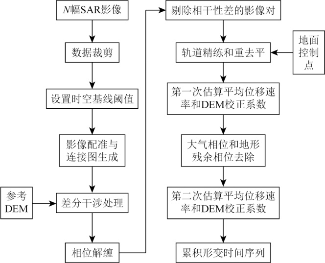
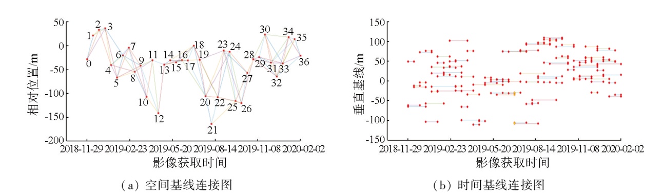
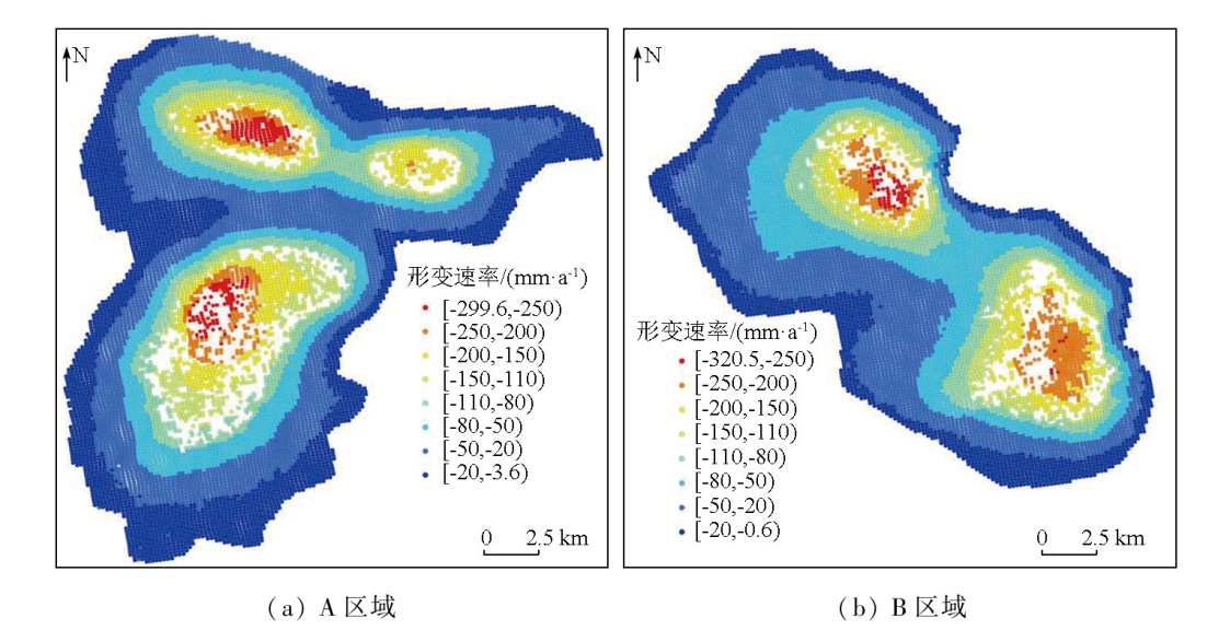
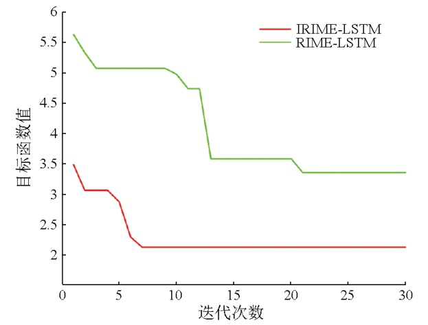
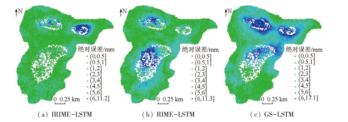
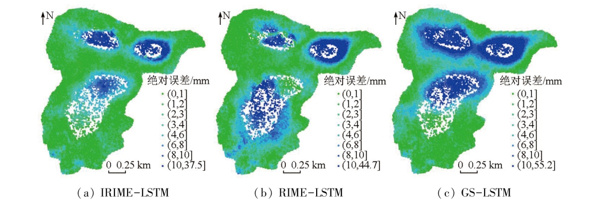
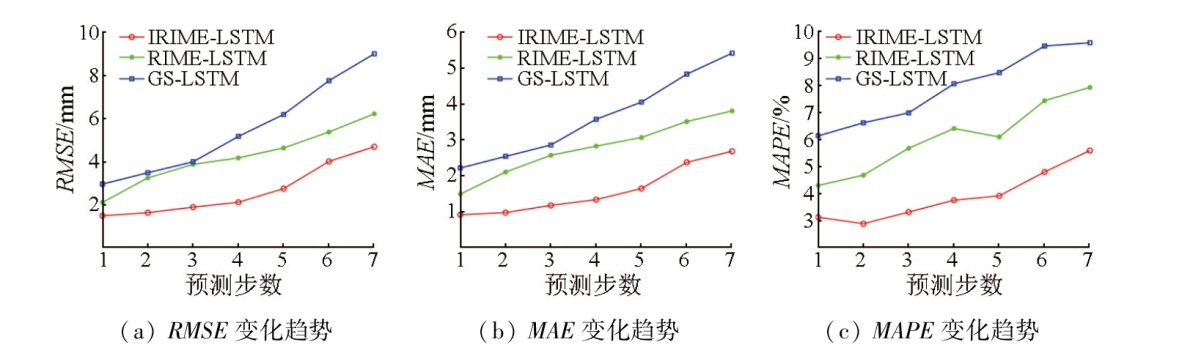
Abstract Interferometric synthetic aperture Radar (InSAR) technology serves as a significant approach for analyzing surface subsidence in large-scale mining areas. Accurately predicting surface subsidence plays a significant role in preventing geological disasters. The long short-term memory (LSTM) network model faces challenges in parameter selection, while the rime optimization algorithm (RIME) is susceptible to local optimum and dependence on the initial solution. Considering these challenges, this study proposed a surface subsidence prediction model with LSTM optimized by the improved rime optimization algorithm (IRIME). The IRIME incorporated chaotic mapping, the improved Lévy flight mechanism, and the global exploration strategy of the hunter-prey optimizer (HPO). The proposed model is also referred to as the IRIME-LSTM model. With the Honghui coal mine as the study area, this study obtained the subsidence time series of highly coherent points in the mining area using small baseline subset (SBAS)-InSAR technology. Subsequently, this study conducted multi-step predictions of these highly coherent points using the IRIME-LSTM model, with the prediction results compared with the InSAR monitoring data. The results of this study indicate that the IRIME-LSTM model yielded a root mean square error (RMSE) of 2.65 mm, a mean absolute error (MAE) of 1.59 mm, and a mean absolute percentage error (MAPE) of 3.92 % in the overall test set. Compared to the RIME-LSTM and GS-LSTM models, the IRIME-LSTM model reduced the RMSE by 37.20 % and 51.73 %, the MAE by 42.60 % and 56.32 %, and the MAPE by 35.63 % and 50.51 %, respectively, demonstrating its high reliability and feasibility.
|
| Keywords
surface subsidence
deep learning
time-series InSAR
subsidence prediction
IRIME-LSTM
|
|
|
|
Issue Date: 01 July 2025
|
|
|
| [1] |
李想, 焦玉勇, 邹俊鹏, 等. 深部采煤覆岩移动和地表沉降研究[J]. 安全与环境工程, 2022, 29(2):32-38,56.
|
| [1] |
Li X, Jiao Y Y, Zou J P, et al. Study on overlying strata movement and ground subsidence in deep coal mining[J]. Safety and Environmental Engineering, 2022, 29(2):32-38,56.
|
| [2] |
顿志林, 王文唱, 邹友峰, 等. 基于时间函数组合模型的采空区地表沉降动态预测及剩余变形计算[J]. 煤炭学报, 2022, 47(s1):13-28.
|
| [2] |
Dun Z L, Wang W C, Zou Y F, et al. Dynamic prediction of surface subsidence and calculation of residual deformation in goaf based on time function combination model[J]. Journal of China Coal Society, 2022, 47(s1):13-28.
|
| [3] |
徐子兴, 季民, 张过, 等. 基于SBAS-InSAR技术和Logistic模型的矿区沉降动态预测方法[J]. 自然资源遥感, 2022, 34(2):20-29.doi:10.6046/zrzyyg.2021354.
|
| [3] |
Xu Z X, Ji M, Zhang G, et al. Method for dynamic prediction of mining subsidence based on the SBAS-InSAR technology and the logistic model[J]. Remote Sensing for Natural Resources, 2022, 34(2):20-29.doi:10.6046/zrzyyg.2021354.
|
| [4] |
谭志祥, 杨嘉威, 邓喀中. 基于SBAS-InSAR的矿区全盆地开采沉陷求参方法研究[J]. 煤炭科学技术, 2021, 49(1):312-318.
|
| [4] |
Tan Z X, Yang J W, Deng K Z. Study on method of mining subsi-dence parameters calculating for whole basin of mining area based on SBAS-InSAR[J]. Coal Science and Technology, 2021, 49(1):312-318.
|
| [5] |
杨旺, 何毅, 张立峰, 等. 甘肃金川矿区地表三维形变InSAR监测[J]. 自然资源遥感, 2022, 34(1):177-188.doi:10.6046/zrzyyg.2021107.
|
| [5] |
Yang W, He Y, Zhang L F, et al. InSAR monitoring of 3D surface deformation in Jinchuan mining area,Gansu Province[J]. Remote Sensing for Natural Resources, 2022, 34(1):177-188.doi:10.6046/zrzyyg.2021107.
|
| [6] |
Riyas M J, Syed T H, Kumar H, et al. Detecting and analyzing the evolution of subsidence due to coal fires in Jharia coalfield,India using sentinel-1 SAR data[J]. Remote Sensing, 2021, 13(8):1521.
|
| [7] |
麻源源, 陈云波, 左小清, 等. Sentinel-1A数据及短基线集的昆明地面沉降分析[J]. 测绘科学, 2019, 44(11):59-66,95.
|
| [7] |
Ma Y Y, Chen Y B, Zuo X Q, et al. Analysis of land subsidence in Kunming based on Sentinel-1A data and SBAS technology[J]. Science of Surveying and Mapping, 2019, 44(11):59-66,95.
|
| [8] |
Ding Y K, Liu R, Fan Y F, et al. Monitoring glaciers in the Chenab Basin with SBAS InSAR technology[J]. Journal of Mountain Science, 2022, 19(9):2622-2633.
|
| [9] |
杨帆, 胡晋, 孙彩霞. InSAR技术结合深度学习的范围性地表沉降预测[J]. 测绘科学, 2022, 47(7):60-68,134.
|
| [9] |
Yang F, Hu J, Sun C X. Prediction of range surface subsidence based on InSAR technology and deep learning[J]. Science of Surveying and Mapping, 2022, 47(7):60-68,134.
|
| [10] |
刘青豪, 张永红, 邓敏, 等. 大范围地表沉降时序深度学习预测法[J]. 测绘学报, 2021, 50(3):396-404.
doi: 10.11947/j.AGCS.2021.20200038
|
| [10] |
Liu Q H, Zhang Y H, Deng M, et al. Time series prediction method of large-scale surface subsidence based on deep learning[J]. Acta Geodaetica et Cartographica Sinica, 2021, 50(3):396-404.
doi: 10.11947/j.AGCS.2021.20200038
|
| [11] |
周文韬, 张文君, 杨元继, 等. 矿区地表沉降监测的一种组合模型预测方法[J]. 大地测量与地球动力学, 2021, 41(3):308-312.
|
| [11] |
Zhou W T, Zhang W J, Yang Y J, et al. A combined model prediction method for surface subsidence monitoring in mining areas[J]. Journal of Geodesy and Geodynamics, 2021, 41(3):308-312.
|
| [12] |
岳振华, 沈涛, 毛曦, 等. 循环神经网络的地面沉降预测方法[J]. 测绘科学, 2020, 45(12):145-152.
|
| [12] |
Yue Z H, Shen T, Mao X, et al. Study on prediction method of land subsidence based on recurrent neural network[J]. Science of Surveying and Mapping, 2020, 45(12):145-152.
|
| [13] |
师芸, 李杰, 吕杰, 等. 结合SBAS-InSAR与支持向量回归的开采沉陷监测与预测[J]. 遥感信息, 2021, 36(2):6-12.
|
| [13] |
Shi Y, Li J, Lyv J, et al. Monitoring and prediction of mining subsidence based on SBAS-InSAR and improved support vector regression[J]. Remote Sensing Information, 2021, 36(2):6-12.
|
| [14] |
鄢涛, 陈波, 曹恩华, 等. 基于EEMD-ELM的大坝变形预测模型[J]. 长江科学院院报, 2020, 37(11):70-73,80.
|
| [14] |
Yan T, Chen B, Cao E H, et al. Prediction of dam deformation using EEMD-ELM model[J]. Journal of Yangtze River Scientific Research Institute, 2020, 37(11):70-73,80.
doi: 10.11988/ckyyb.20190892
|
| [15] |
Su H, Zhao D, Heidari A A, et al. RIME:A physics-based optimization[J]. Neurocomputing, 2023,532:183-214.
|
| [16] |
Wang X, Li J, Shao L, et al. Short-term wind power prediction by an extreme learning machine based on an improved hunter-prey optimization algorithm[J]. Sustainability, 2023, 15(2):991.
|
| [17] |
葛唱, 钱素琴. 改进麻雀搜索算法的无人车路径规划[J]. 导航定位学报, 2022, 10(6):107-111.
|
| [17] |
Ge C, Qian S Q. Path planning of unmanned vehicle based on improved sparrow search algorithm[J]. Journal of Navigation and Positioning, 2022, 10(6):107-111.
|
| [18] |
刘辉, 徐心月, 陈蜜, 等. 秦皇岛段明长城时序InSAR遥感动态监测[J]. 自然资源遥感, 2023, 35(2):202-211.doi:10.6046/zrzyyg.2021163.
|
| [18] |
Liu H, Xu X Y, Chen M, et al. Time-series InSAR-based dynamic remote sensing monitoring of the Great Wall of the Ming Dynasty in Qinhuangdao[J]. Remote Sensing for Natural Resources, 2023, 35(2):202-211.doi:10.6046/zrzyyg.2021163.
|
| [19] |
肖海平, 夏益强, 刘小生, 等. 融合SBAS-InSAR技术与TSO-LSTM模型的矿区地表沉降预测方法[J]. 金属矿山, 2023(1):126-133.
|
| [19] |
Xiao H P, Xia Y Q, Liu X S, et al. Prediction method of surface subsidence in mining area by the integration of SBAS-InSAR technique and TSO-LSTM model[J]. Metal Mine, 2023(1):126-133.
|
| [20] |
刘青豪, 刘慧敏, 张永红, 等. 顾及空间异质性的大范围地面沉降时空预测[J]. 遥感学报, 2022, 26(7):1315-1325.
|
| [20] |
Liu Q H, Liu H M, Zhang Y H, et al. A spatio-temporal prediction method of large-scale ground subsidence considering spatial hete-rogeneity[J]. National Remote Sensing Bulletin, 2022, 26(7):1315-1325.
|
| [21] |
刘宝宝, 杨菁菁, 陶露, 等. 基于DE-LSTM模型的教育统计数据预测研究[J]. 计算机科学, 2022, 49(s1):261-266.
|
| [21] |
Liu B B, Yang J J, Tao L, et al. Study on prediction of educational statistical data based on DE-LSTM model[J]. Computer Science, 2022, 49(s1):261-266.
|
|
Viewed |
|
|
|
Full text
|
|
|
|
|
Abstract
|
|
|
|
|
Cited |
|
|
|
|
| |
Shared |
|
|
|
|
| |
Discussed |
|
|
|
|
 2025,
Vol. 37
2025,
Vol. 37