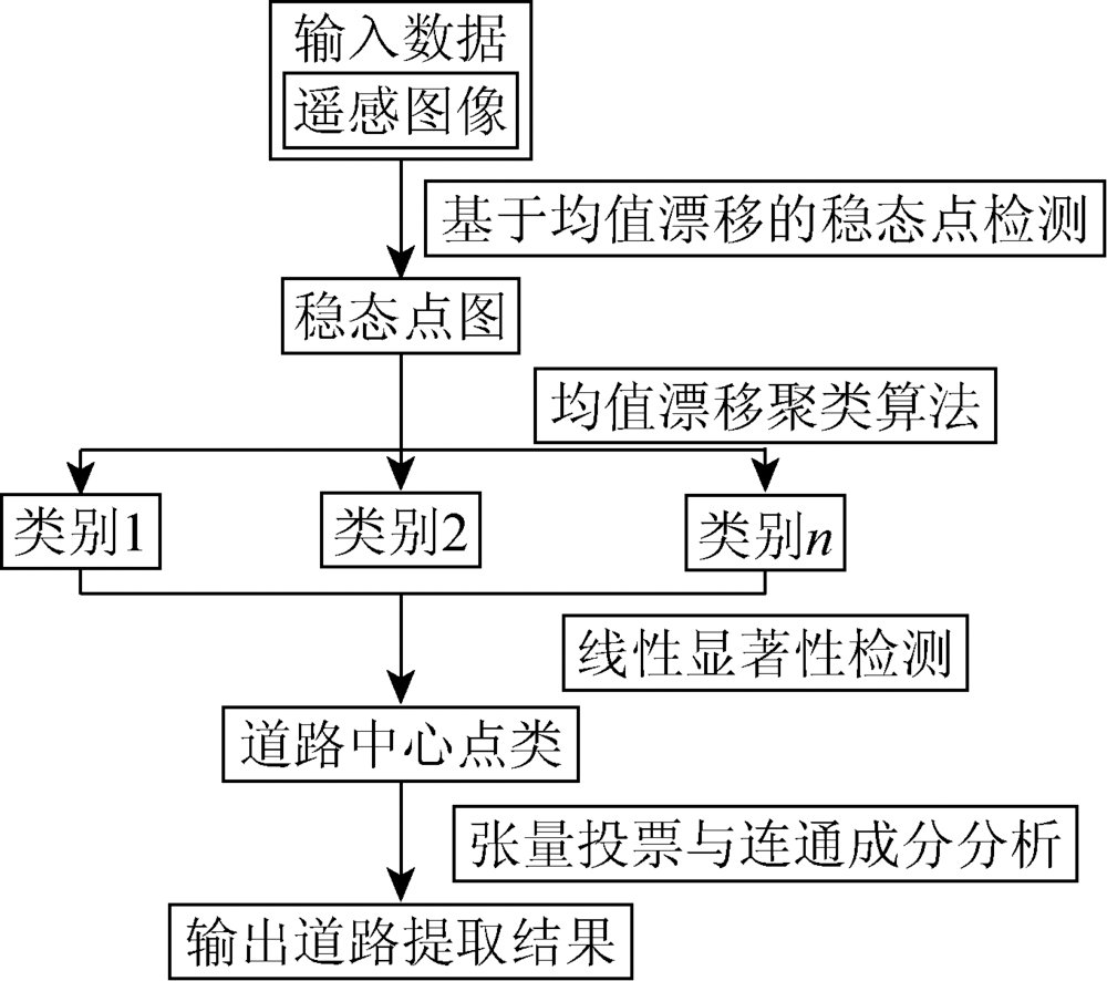
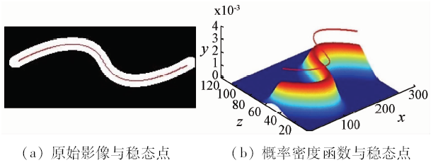
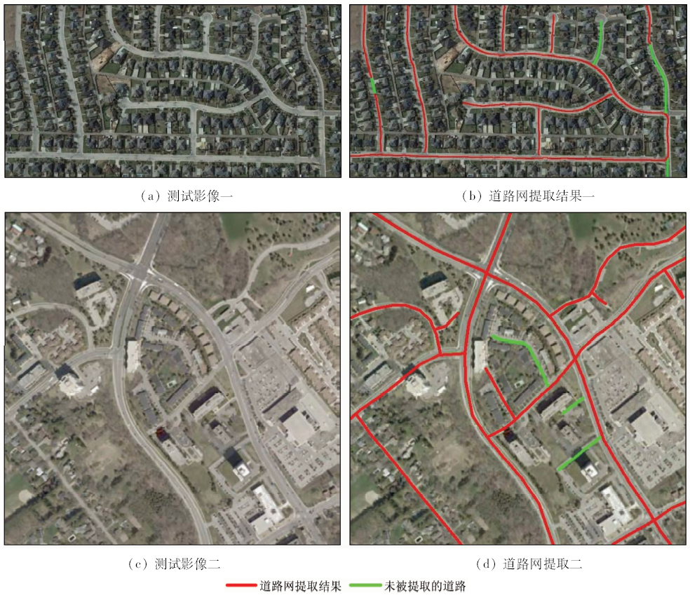
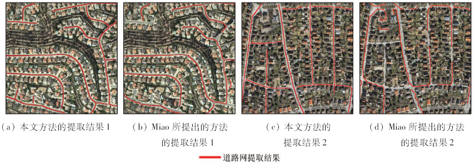
Roads on the high-resolution remote sensing images perform the stripe homogeneous region with ribbon-like shape and approximate width. According to these features, this paper presents a simple yet effective method of delineating road networks from high-resolution remote sensing images, which combines multi features and methods. The proposed method consists of three main steps. First, the mean shift algorithm is utilized to detect the modes of density of image points in spectral-spatial space which contain potential road center points and then detected mode points are classified into different classes by mean shift-based clustering on the basis of spectral information. Next, the combination of Gabor filtering and tensor encoding is used to identify the road class and to extract road center points. Lastly, road network is generated from detected road center points by means of tensor voting and connected component analysis. The experimental results demonstrate good performances of the proposed method in road network extraction, much better than the method proposed by Miao et al.
Liu Y, Fu Z Y, Zheng F B . Review on high resolution remote sensing image classification and recognition[J]. Journal of Geo-Information Science, 2015,17(9):1080-1091.
Shi W Z, Zhu C Q, Wang Y . Road feature extraction from remotely sensed image:review and prospects[J]. Acta Geodaetica et Cartographica Sinica, 2001,30(3):257-262.
Zhou S G, Chen C, Yue J P . Extracting roads from high-resolution RS images based on shape priors and graph Cuts[J]. Acta Geodaetica et Cartographica Sinica, 2014,43(1):60-65.
Zhou S G, Xiang J, Qiu W , et al. A study of road centerline extraction from high resolution image[J]. Remote Sensing for Land and Resources, 2015,27(4):21-26.doi: 10.6046/gtzyyg.2015.04.04.
Lei X Q, Wang W X, Lai J . A method of road extraction from high-resolution remote sensing images based on shape features[J]. Acta Geodaetica et Cartographica Sinica, 2009,38(5):457-465.
Zhu C Q, Wang Y G, Ma Q H , et al. Road extraction from high-resolution remotely sensed image based on morphological segmentation[J]. Acta Geodaetica et Cartographica Sinica, 2004,33(4):347-351.
[7]
Poullis C, You S Y . Delineation and geometric modeling of road networks[J]. ISPRS Journal of Photogrammetry and Remote Sensing, 2010,65(2):165-181.
doi: 10.1016/j.isprsjprs.2009.10.004
[8]
Mena J B . State of the art on automatic road extraction for GIS update:A novel classification[J]. Pattern Recognition Letters, 2003,24(16):3037-3058.
doi: 10.1016/S0167-8655(03)00164-8
[9]
Song M J, Civco D . Road extraction using SVM and image segmentation[J]. Photogrammetric Engineering and Remote Sensing, 2004,70(12):1365-1371.
doi: 10.14358/PERS.70.12.1365
[10]
Shi W Z, Miao Z L, Wang Q M , et al. Spectral-spatial classification and shape features for urban road centerline extraction[J]. IEEE Geoscience and Remote Sensing Letters, 2014,11(4):788-792.
doi: 10.1109/LGRS.2013.2279034
[11]
Miao Z L, Shi W Z, Zhang H , et al. Road centerline extraction from high-resolution imagery based on shape features and multivariate adaptive regression splines[J]. IEEE Geoscience and Remote Sensing Letters, 2013,10(3):583-587.
doi: 10.1109/LGRS.2012.2214761
[12]
Miao Z L, Shi W Z . Road centreline extraction from classified images by using the geodesic method[J]. Remote Sensing Letters, 2014,5(4):367-376.
doi: 10.1080/2150704X.2014.907935
[13]
Das S, Mirnalinee T T, Varghese K . Use of salient features for the design of a multistage framework to extract roads from high-resolution multispectral satellite images[J]. IEEE Transactions on Geoscience and Remote Sensing, 2011,49(10):3906-3931.
doi: 10.1109/TGRS.2011.2136381
Cao F Z, Zhu S L, Zhu B S , et al. Tracking Road centerlines from remotely sensed imagery using mean shift and Kalman filtering[J]. Acta Geodaetica et Cartographica Sinica, 2016,45(2):205-212,223.
[15]
Fukunaga K, Hostetler L D . The estimation of the gradient of a density function,with applications in pattern recognition[J]. IEEE Transactions on Information Theory, 1975,21(1):32-40.
doi: 10.1109/TIT.1975.1055330
[16]
Cheng Y Z . Mean shift,mode seeking, and clustering[J]. IEEE Transactions on Pattern Analysis and Machine Intelligence, 1995,17(8):790-799.
doi: 10.1109/34.400568
[17]
Cover T M, Thomas J A . Elements of Information Theory[M]. Chichester:John Wiley & Sons, 2012.
[18]
Daugman J G . Uncertainty relation for resolution in space,spatial frequency,and orientation optimized by two-dimensional visual cortical filters[J]. Journal of the Optical Society of America A, 1985,2(7):1160-1169.
doi: 10.1364/JOSAA.2.001160
[19]
Medioni G, Tang C K, Lee M S . Tensor voting: theory and applications[J]. Proceedings of Rfia, 2000,34(8):1482-1495.
doi: 10.1109/TPAMI.2011.250
[20]
Mordohai P, Medioni G . Tensor Voting:A Perceptual Organization Approach to Computer Vision and Machine Learning[M]. California: Morgan & Claypool, 2006: 1-136.
 2018, Vol. 30
  ), 曹闻, 王淑香