1. Xi’an Northwest Geological Institude of Nonferrous Metals Ltd, Xi’an 710054, China 2. Chengdu Center of China Geological Survey, Chengdu 610081, China
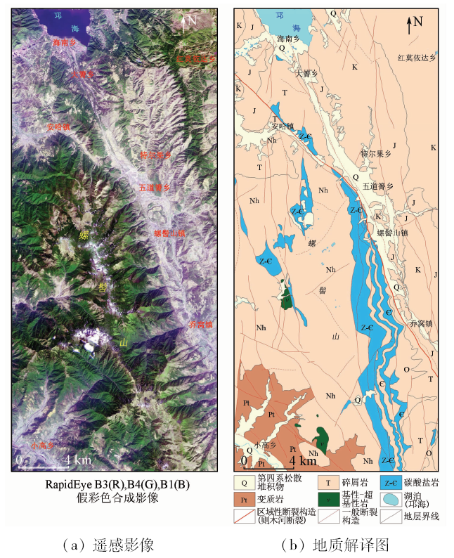
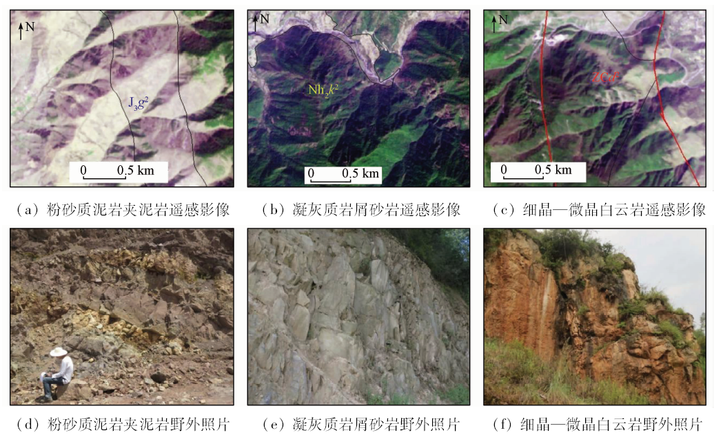
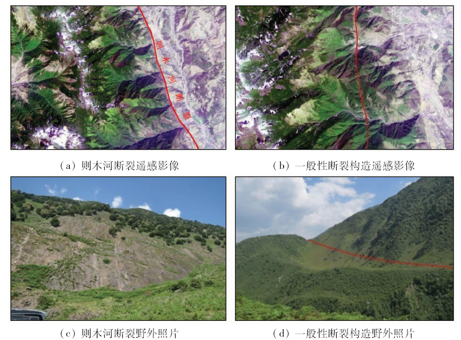
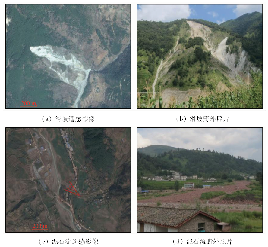
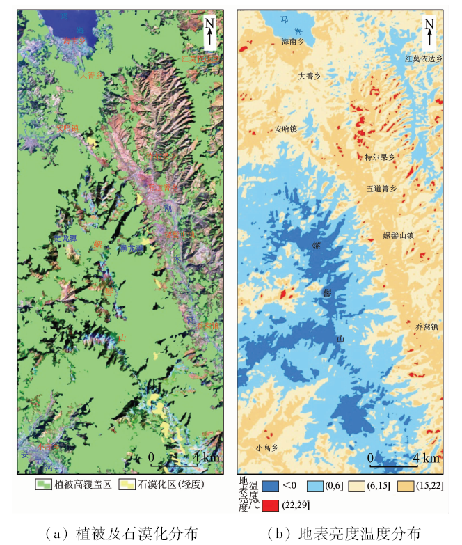
Based on an analysis of geological structure and environmental geological conditions in the Luojishan area, western Sichuan, the authors comprehensively interpreted and analyzed the basic geological elements such as formation and structure, hydrogeological elements such as surface water and groundwater, geological hazards, vegetation, cultivated land, residential land, surface temperature and other environmental geological factors by using RapidEye data, Landsat8 OLI data and network high-definition data images. Combined with the field survey data, the authors evaluated the hydrogeological environment of the study area and, based on remote sensing information, graded the water richness of water-bearing rocks, and divided them into abundant water resource area, medium water resource area and poor water resource area, which provides basic remote sensing data for carrying out further hydrogeological survey work in this area.
Xiong S Q . The progress and development trend of the application of remote sensing to land and resources[J]. Remote Sensing for Land and Resources, 2007,19(4):1-6.doi: 10.6046/gtzyyg.2007.04.01.
Xu G H, Liu Q H, Chen L F , et al. Remote sensing for China’s sustainable development:Opportunities and challenges[J]. Journal of Remote Sensing, 2016,20(5):679-688.
Wang R S, Xiong S Q, Nie H F , et al. Remote sensing technology and its application in geological exploration[J]. Acta Geologica Sinica. 2011,85(11):1699-1743.
Gu X F, Yu T, Tian G L , et al. Up to the higher altitude—the new “three campaigns” for the development of China spaceborne remote sensing application[J]. Journal of Remote Sensing, 2016,20(5):781-793.
Liu D C, Li Z Z, Wang J H . The technology progress and developing future of remote sensing geological prospecting in China[J]. Journal of Geo-information Science, 2011,13(04):431-438.
Chen F Q, Xue S, Feng Y , et al. Application of remote sensing on metallogenic prognosis in west Mangling Pluton[J]. Remote Sensing Information, 2016,31(1):102-105.
Wang B, Zhang D M, Wei B Z , et al. The application of high resolution remote sensing image to ore prediction in Skarn copper polymetallic deposit,Kaerqueka area,Qinhai[J]. Contributions to Geology and Mineral Resources Research, 2017,32(1):107-113.
Chen F Q, Jiao C W, Zhang Y F , et al. Remote sensing geological characteristics and prospecting prediction in Nan mountain of Da Tong ditch,Mangai Area,Qinghai[J]. Contributions to Geology and Mineral Resources Research, 2017,32(4):612-618.
Li X M, Yan Y P, Liu G , et al. Application of ZY-102C satellite data to hydrogeological investigation in Zanda area,Tibet[J]. Remote Sensing for Land and Resources, 2016,28(4):141-148.doi: 10.6046/gtzyyg.2016.04.22.
Deng Z D, Ye X, Long F , et al. Construction and investigation of groundwater remote sensing fuzzy assessment index[J]. Chinese Journal of Geophysics, 2013,56(11):3908-3916.
Yang Q H, Chen H, Lu Y G , et al. Basic geological remote sensing survey in national terrestrial and marine border region[J]. Geological Survey of China, 2017,4(3):1-9.
An G Y . Application of satellite remote sensing in regional hydrogeological investigation:Taking Cenozoic Strata in Wenquan sheet (1:250,000) of Karakoram range as an example[J]. Geoscience, 2013,27(6):1445-1453.
Qi R, Wang X S, Wan L , et al. Joint influences of groundwater and aridity index on the spatial distribution of vegetation index:A case study in the Ordos Plateau,China[J]. Earth Science Frontiers, 2017,24(2):265-273.
Cheng Y, Lv Y, Tu J N , et al. Application of remote sensing technology in the 1:50000 regional geological survey in karst area:A case study of northwest Guizhou[J]. Journal of Geomechanics, 2016,22(4):921-932.
Yuan M X, Zou L, Lin A W , et al. Analyzing dynamic vegetation change and response to climatic factors in Hubei Province,China[J]. Acta Ecologica Sinica, 2016,36(17):5315-5323.
[18]
覃志豪 , Zhang M H, Arnon Karnieli, 等. 用陆地卫星TM6数据演算地表温度的单窗算法[J].地理学报,2001(4):456-466.
Qin Z H, Zhang M H, Arnon Karnieli , et al. Mono-window algorithm for retrieving land surface temperature from Landsat TM6 data[J].Acta Geographica Sinica,2001(4):456-466.
[19]
覃志豪, Li W J, Zhang M H, 等. 单窗算法的大气参数估计方法[J]. 国土资源遥感, 2003,15(2):37-43.doi: 10.6046/gtzyyg.2003.02.10.
doi: 10.6046/gtzyyg.2003.02.10
Qin Z H, Li W J, Zhang M H , et al. Estimating of the essential atmospheric parameters of mono-window algorithm for land surface temperature retrieval from Landsat TM6[J]. Remote Sensing for Land and Resources, 2003,15(2):37-43.doi: 10.6046/gtzyyg.2003.02.10.
Hu D Y, Qiao K, Wang X L , et al. Land surface temperature retrieval from Landsat 8 thermal infrared data using mono-window algorithm[J]. Journal of Remote Sensing, 2015,19(6):964-976.
 2019, Vol. 31