A registration algorithm of images with special textures coupling a watershed with mathematical morphology
ZANG Liri1(), YANG Shuwen1,2,3(), SHEN Shunfa1, XUE Qing1, QIN Xiaowei1
1. Faculty of Geomatics, Lanzhou Jiaotong University, Lanzhou 730070, China 2. National-Local Joint Engineering Research Center of Technologies and Applications for National Geographic State Monitoring, Lanzhou 730070, China 3. Gansu Provincial Engineering Laboratory for National Geographic State Monitoring, Lanzhou 730070, China
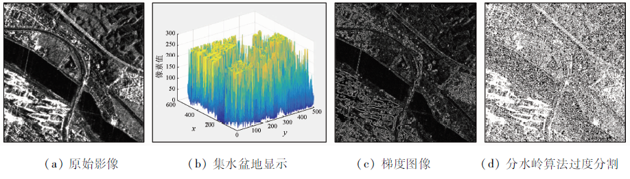
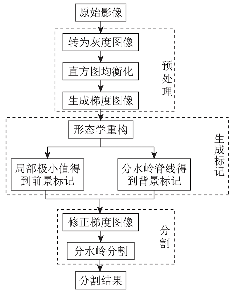
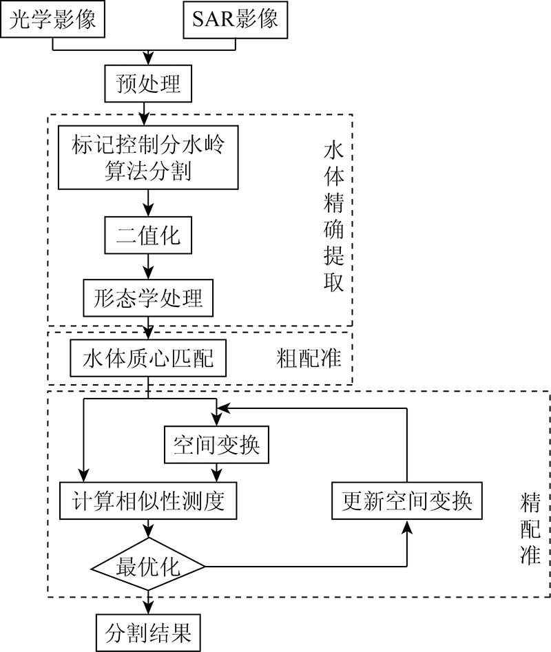
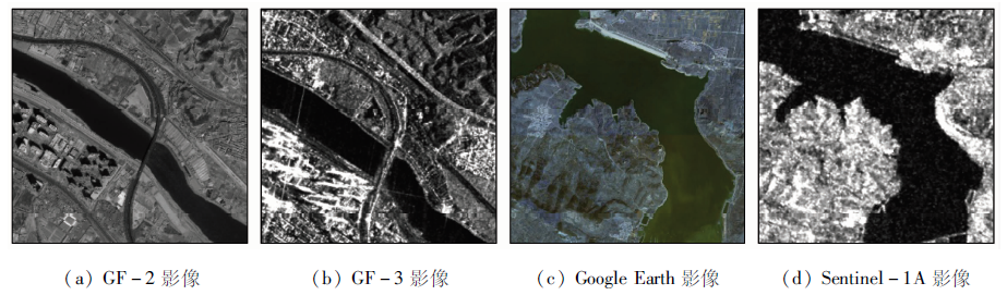
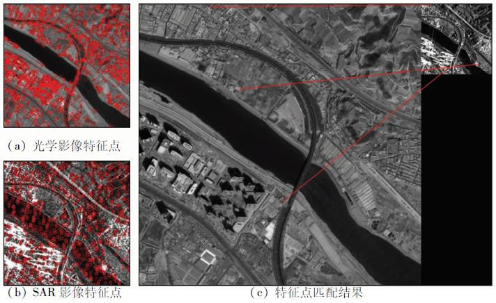
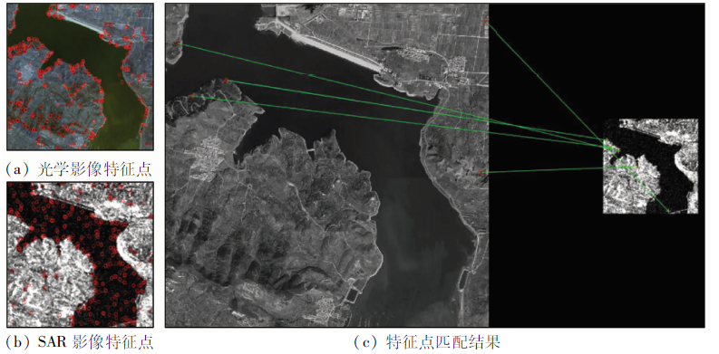
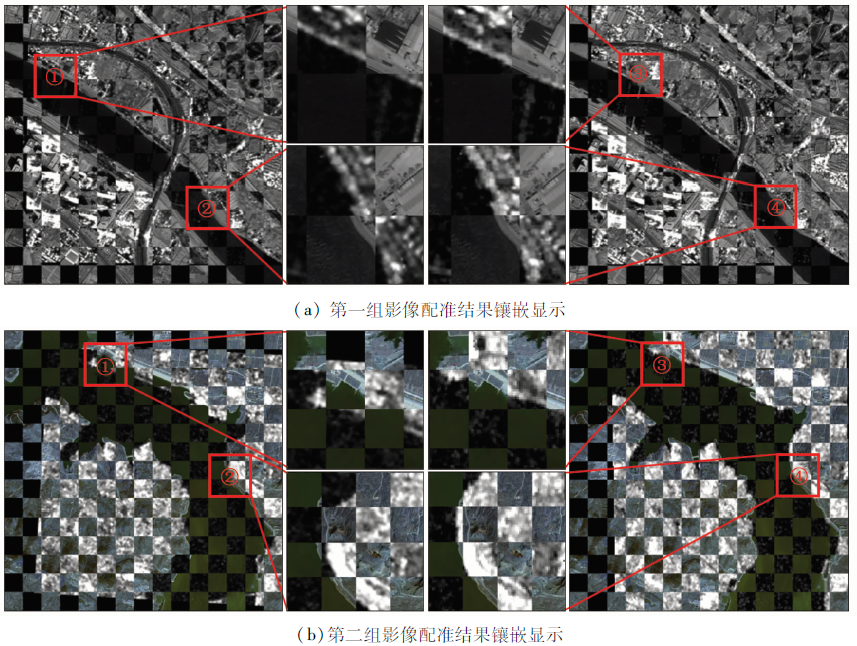
Existing registration algorithms suffer low efficiency and accuracy in the registration of synthetic aperture Radar (SAR) and optical images. This study proposed a stepwise refinement-based automatic registration algorithm of images with special textures by coupling marker-controlled watershed segmentation and mathematical morphology. Firstly, the improved marker-controlled watershed algorithm was used to extract the features of water bodies from images, and then binarization and mathematical morphology were applied to accurately extract the water regions. Secondly, the centroids of water bodies were extracted for rough registration between images to improve the search efficiency of the subsequent algorithm. Finally, using the optimization algorithm, the optimal transformation parameters when the similarity measure was maximized were obtained and were used to carry out the spatial transformation of SAR images for image registration. In this manner, the precise registration of SAR and optical images was completed. The experimental results show that the algorithm proposed in this study that couples image segmentation with registration reduced calculation amount while ensuring the registration accuracy. Meanwhile, this algorithm effectively solved the difficulty in the automatic registration of SAR and optical high-resolution images that have large differences in gray levels and spatial resolution.
Li D C, Xiang W H, Dang Q N, et al. SAR and optical images registration using uniform distribution and structure description-based ASIFT[J]. Acta Geodaetica et Cartographica Sinica, 2020, 49(12):1583-1590.
Ye Y X, Hao S Y, Cao Y G. Automatic registration of optical and SAR image using geometric structural properties[J]. Journal of Infrared and Millimeter Waves, 2017, 36(6):720-726.
[3]
Ye Y X, Bruzzone L, Shan J, et al. Fast and robust matching for multimodal remote sensing image registration[J]. IEEE Transactions on Geoscience and Remote Sensing, 2019, 57(11):9059-9070.
doi: 10.1109/TGRS.36
Zhang M X, Wang Z G, Bai R Y, et al. A coarse-to-fine optical and SAR remote sensing image registration algorithm[J]. Journal of Geo-Information Science, 2020, 22(11):2238-2246.
[5]
Lowe D G. Distinctive image features from scale-invariant keypoints[J]. International Journal of Computer Vision, 2004, 60(2):91-110.
doi: 10.1023/B:VISI.0000029664.99615.94
[6]
Bay H, Tuytelaars T, Gool L V. SURF:Speeded up robust features[C]// European Conference on Computer Vision.Springer, 2006:404-417.
[7]
Schwind P, Suri S, Reinartz P, et al. Applicability of the SIFT operator to geometric SAR image registration[J]. International Journal of Remote Sensing, 2010, 31(7-8):1959-1980.
doi: 10.1080/01431160902927622
[8]
Xiang Y, Wang F, You H. OS-SIFT:A robust SIFT-like algorithm for high-resolution optical-to-SAR image registration in suburban areas[J]. IEEE Transactions on Geoscience and Remote Sensing, 2018, 56(6):3078.
doi: 10.1109/TGRS.2018.2790483
Wang Z S, Yang F B, Ji L E, et al. Optical and SAR image registration based on cluster segmentation and mathematical morphology[J]. Acta Optica Sinica, 2014, 34(2):184-190.
Yang Y, Hu S R. Registration of optical and SAR images based on template matching constraints[J]. Systems Engineering and Electronics, 2019, 41(10):2235-2242.
[11]
Vincent L, Soille P. Watersheds in digital spaces:An efficient algorithm based on immersion simulations[J]. IEEE Transactions on Pattern Analysis and Machine Intelligence, 1991, 13(6):583-598.
doi: 10.1109/34.87344
Han J H, He C T, Zhang Q H, et al. Morphological analysis of laser induced glass bulk damage by marker controlling watershed algorithm[J]. Optics and Precision Engineering, 2010, 18(6):1387-1395.
[13]
Parvati K, Prakasa Rao B S, et al. Image segmentation using gray-scale morphology and marker-controlled watershed transformation[J]. Discrete Dynamics in Nature and Society, 2008:307-318.
[14]
Genitha C H, Sowmya M, Sri T. Comparative analysis for the detection of marine vessels from satellite images using FCM and marker-controlled watershed segmentation algorithm[J]. Journal of the Indian Society of Remote Sensing, 2020, 48(8):1207-1214.
doi: 10.1007/s12524-020-01148-x
[15]
Li P, Xiao X. Multispectral image segmentation by a multichannel watershed-based approach[J]. International Journal of Remote Sensing, 2007, 28(19):4429-4452.
doi: 10.1080/01431160601034910
[16]
冈萨雷斯. 数字图像处理(第三版)[M]. 北京: 电子工业出版社, 2017:414-415.
Gonzalez. Digital image processing (3rd Edition)[M]. Beijing:Publishing House of Electronics Industry, 2017:414-415.
Yi W W, Yang B B, Hu Y L, et al. Contour-based registration algorithm and its implementation[J]. Computer Technology and Development, 2008(4):1-4,8.
[18]
Otsu N. Threshold selection method from gray-level histograms[J]. IEEE Transactions on Systems Man and Cybernetics, 1979, 9.
[19]
Adams R, Bishof L. Seeded region growing[J]. IEEE Transactions on Pattern Analysis and Machine Intelligence, 1994.
[20]
Dellinger F, Delon J, Gousseau Y, et al. SAR-SIFT:A SIFT-like algorithm for SAR images[J]. IEEE Transactions on Geoscience and Remote Sensing, 2013, 53(1):453-466.
doi: 10.1109/TGRS.2014.2323552
[21]
Wang X, Duan L, Fan Y, et al. A multi-sensor image matching method based on KAZE-HOG features[C]// 2019 IEEE 4th International Conference on Image,Vision and Computing (ICIVC).IEEE, 2019.
[22]
孙铭. 基于梯度互信息的SAR与可见光图像配准[D]. 西安:西安电子科技大学, 2015.
Sun M. SAR and optical image registration based on gradient mutual information[D]. Xi’an:Xidian University, 2015.
Ye F M, Luo W, Su Y F, et al. Application of convolutional neural network feature to remote sensing image registration[J]. Remote Sensing for Land and Resources, 2019, 31(2):32-37.doi: 10.6046/gtzyyg.2019.02.05.
doi: 10.6046/gtzyyg.2019.02.05
 2022, Vol. 34
  ), 杨树文1,2,3(