Please wait a minute...
 
自然资源遥感  2023, Vol. 35 Issue (4): 25-33    DOI: 10.6046/zrzyyg.2022265
  技术方法 本期目录 | 过刊浏览 | 高级检索 |
质量引导下的最小二乘相位解缠算法
肖晖1,2(), 李惠堂1(), 顾约翰1, 盛庆红1
1.南京航空航天大学航天学院,南京 210016
2.南京晓庄学院环境科学学院,南京 211171
A quality-guided least squares phase unwrapping algorithm
XIAO Hui1,2(), LI Huitang1(), GU Yuehan1, SHENG Qinghong1
1. College of Astronautics, Nanjing University of Aeronautics and Astronautics, Nanjing 210016, China
2. School of Environmental Sciences, Nanjing Xiaozhuang University, Nanjing 211171, China
全文: PDF(8125 KB)   HTML  
输出: BibTeX | EndNote (RIS)      
摘要 

干涉合成孔径雷达(interferometric synthetic aperture Radar,InSAR)利用干涉图的相位信息提取地面目标的三维信息,相位解缠是InSAR处理流程中的重要步骤,解缠结果的精确性直接决定获取数字高程模型(digital elevation model,DEM)或者地表形变信息的精度。针对复杂山区中严重的相位失相关和相位噪声问题,划分研究区域干涉相位质量高低,提出了质量引导下的最小二乘相位解缠算法,对模拟的低噪声干涉相位数据和中国秦岭地区Sentinel-1A InSAR干涉影像对数据进行相位解缠,结果表明所提算法能有效改善高低质量区域间的相位一致性,提高相位解缠整体精度。

服务
把本文推荐给朋友
加入引用管理器
E-mail Alert
RSS
作者相关文章
肖晖
李惠堂
顾约翰
盛庆红
关键词 InSAR相位解缠质量引导法最小二乘法    
Abstract

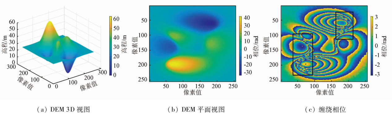
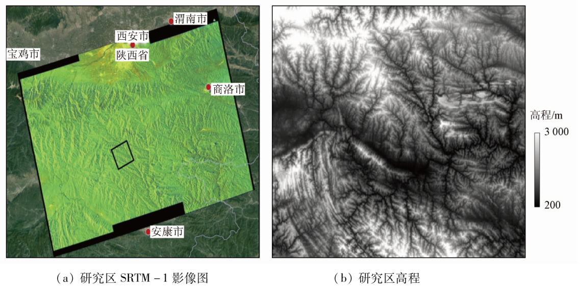
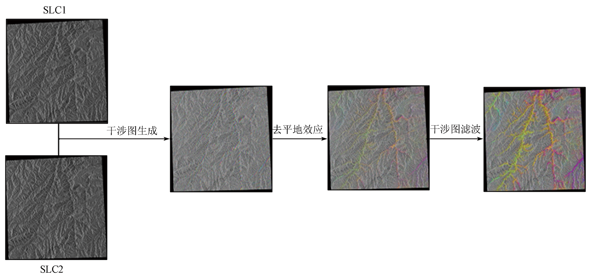
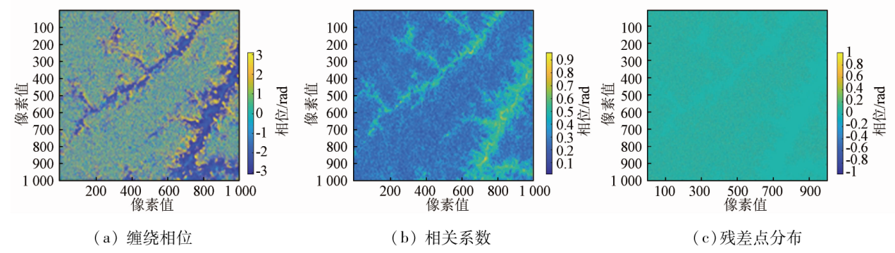
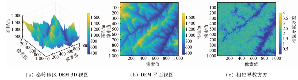
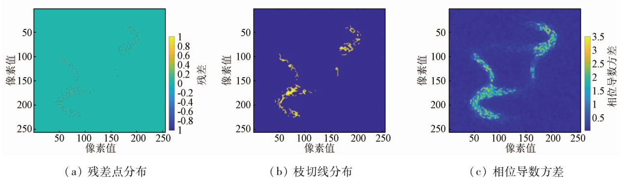
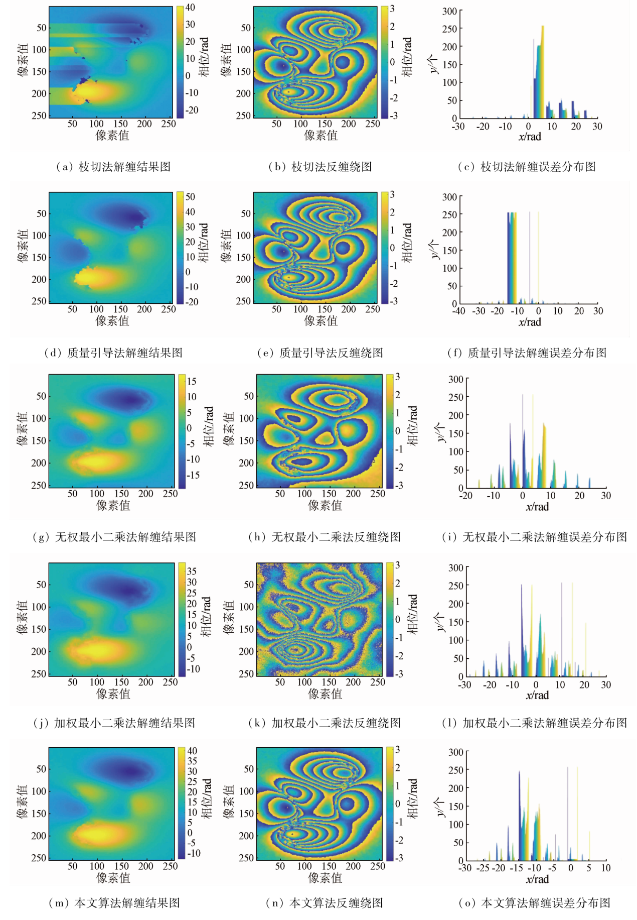
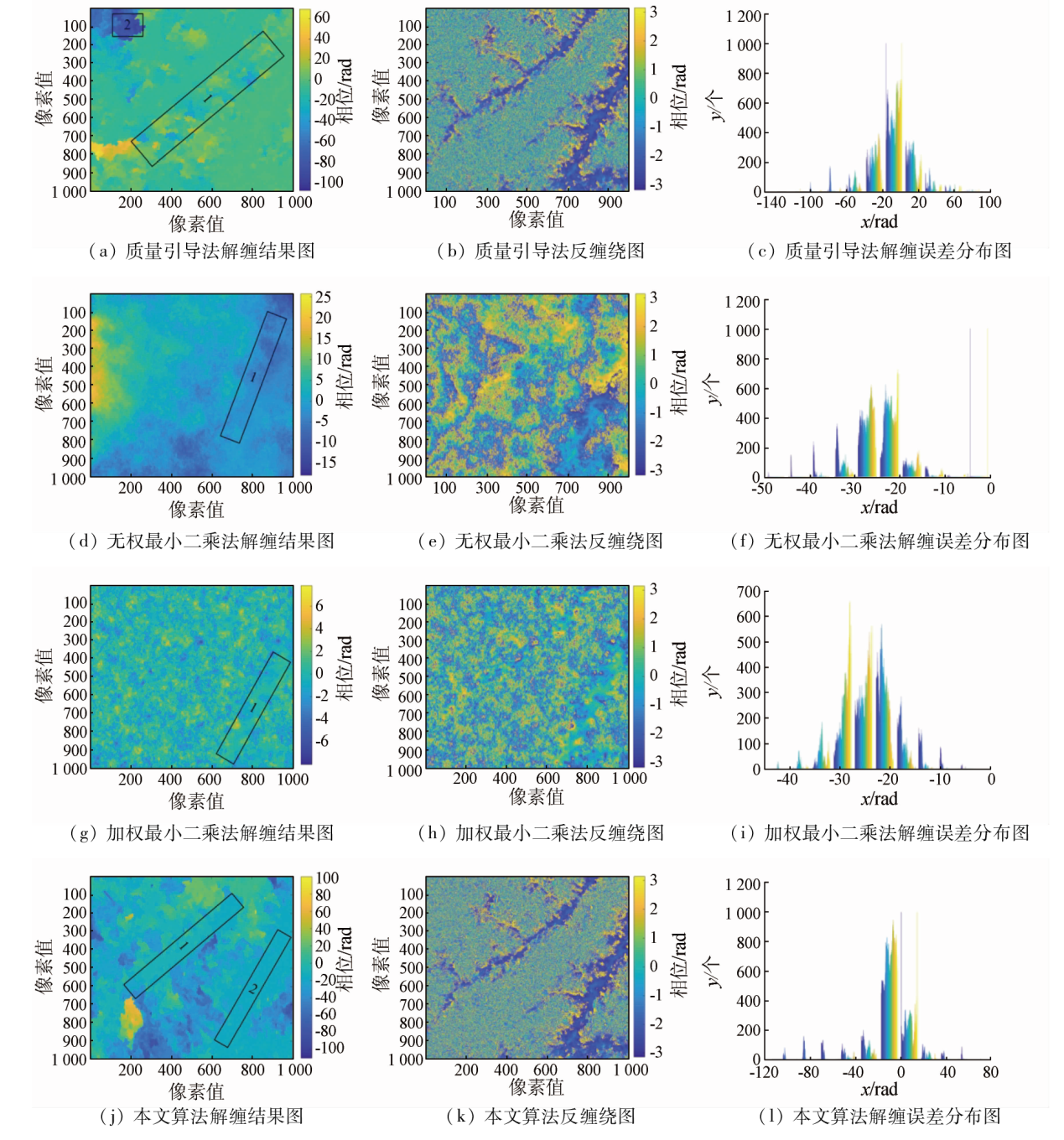
Interferometric synthetic aperture Radar (InSAR) can extract three-dimensional information about a ground target from the phase information in an interferogram. Phase unwrapping is an important step in the InSAR process, and its accuracy dictates the accuracy of the digital elevation model (DEM) or the ground deformation information. To overcome the serious phase decorrelation and phase noise in complex mountainous areas, this study divided the study area according to the quality of interference phases and proposed a quality-guided least squares phase unwrapping algorithm. Then, the algorithm was employed for the phase unwrapping of simulated low-noise interferometric phase data and Sentinel-1A InSAR interferometric images of the Qinling area of China. The results show that the proposed algorithm can effectively improve the phase consistency among high- and low-quality zones and the overall accuracy of phase unwrapping.

Key wordsInSAR    phase unwrapping    quality-guided method    least squares method
收稿日期: 2022-07-04      出版日期: 2023-12-21
ZTFLH:  TP79  
基金资助:国家自然科学基金项目“基于商空间粒度合并的控制数据选优定权方法研究”(41701531)
通讯作者: 李惠堂(1996-),男,博士研究生,研究方向为遥感数据处理。Email: lht1369776691@163.com
作者简介: 肖晖(1978-),男,副教授,研究方向为遥感数据处理。Email: xiaohui@njxzc.edu.cn
引用本文:   
肖晖, 李惠堂, 顾约翰, 盛庆红. 质量引导下的最小二乘相位解缠算法[J]. 自然资源遥感, 2023, 35(4): 25-33.
XIAO Hui, LI Huitang, GU Yuehan, SHENG Qinghong. A quality-guided least squares phase unwrapping algorithm. Remote Sensing for Natural Resources, 2023, 35(4): 25-33.
链接本文:  
https://www.gtzyyg.com/CN/10.6046/zrzyyg.2022265      或      https://www.gtzyyg.com/CN/Y2023/V35/I4/25
Fig.1  模拟数据
Fig.2  研究区域相关影像
Fig.3  干涉影像对流程化处理
Fig.4  干涉相位相关数据
Fig.5  重采样后DEM相关数据
Fig.6  干涉相位相关图像
Fig.7  解缠结果
相位解缠算法 RMSE/rad
枝切法 7.37
质量引导法 2.37
无权最小二乘法 7.11
加权最小二乘法 4.07
本文算法 2.00
Tab.1  不同算法的解缠结果RMSE
Fig.8  真实数据解缠结果
相位解缠算法 RMSE/rad
枝切法 解缠失败
质量引导法 20.08
无权最小二乘法 24.38
加权最小二乘法 24.04
本文算法 16.47
Tab.2  真实数据各算法解缠结果RMSE统计
[1] 周伟文. 利用星载InSAR 技术获取DEM及误差来源分析[J]. 测绘与地理信息, 2019, 42(2):135-137.
Zhou W W. Analysis of DEM and error sources using spaceborne InSAR technique[J]. Geomatics and Spatial Information Technology, 2019, 42(2):135-137.
[2] Rosen P A, Hensley S, Joughin I R, et al. Synthetic aperture Radar interferometry[J]. Proceedings of the IEEE, 2000, 88(3):333-382.
doi: 10.1109/5.838084
[3] Gao Y, Zhang S, Li T, et al. Adaptive unscented Kalman filter phase unwrapping method and its application on Gaofen-3 interferometric SAR data[J]. Sensors, 2018, 18(6):1793.
doi: 10.3390/s18061793
[4] 余博, 李如仁, 陈振炜, 等. “高分三号”卫星图像干涉测量试验[J]. 航天返回与遥感, 2019, 40(1):66-73.
Yu B, Li R R, Chen Z W, et al. Image interferometry experiment of GF-3 satellite[J]. Spacecraft Recovery and Remote Sensing, 2019, 40(1): 66-73.
[5] Sheng Q H, Li H T, Guo Y H, et al. Minimum cost flow phase unwrapping method considering range direction slope[J]. Journal of Applied Remote Sensing, 2022, 16(1): 014517.
[6] 刘国祥, 陈强, 罗小军. InSAR原理与应用[M]. 北京: 科学出版社, 2019.
Liu G X, Chen Q, Luo X J. Principle and application of InSAR[M]. Beijing: Science Press, 2019.
[7] Gabriel A K, Goldstein R M, Zebker H A. Mapping small elevation changes over large areas:Differential Radar interferometry[J]. Journal of Geophysical Research Solid Earth:Solid Earth, 1989, 94(b7): 9183-9191.
[8] Bone D J. Fourier fringe analysis:The two-dimensional phase unwrapping problem[J]. Applied Optics, 1991, 30(25):3627-3632.
doi: 10.1364/AO.30.003627 pmid: 20706437
[9] 岑小林, 毛建旭. 质量图和残差点相结合的InSAR相位解缠方法[J]. 遥感技术与应用, 2008, 23(5):556-560.
Cen X L, Mao J X. InSAR phase unwrapping method using quality map with residues[J]. Remote Sensing Technology and Application, 2008, 23(5):556-560.
[10] 赵振强. 基于深度学习的InSAR相位解缠算法研究[D]. 北京: 中国地质大学(北京), 2019.
Zhao Z Q. Research on InSAR phase unwrapping algorithm based on deep learning[D]. Beijing: China University of Geoscience(Beijing), 2019.
[11] Ghiglia D C, Romero L A. Minimum Lp-norm two-dimensional phase unwrapping[J]. Journal of the Optical Society of America A, 1996, 13(10):1999-2013.
doi: 10.1364/JOSAA.13.001999
[12] Lei Y, Qian F, Gang W Z. Optimized minimum spanning tree phase unwrapping algorithm for phase image of interferometric SAR[C]// 2006 6th International Conference on ITS Telecommunications.IEEE, 2006:1240-1243.
[13] 钱晓凡, 王占亮, 胡特, 等. 用单幅数字全息和剪切干涉原理重构光场相位[J]. 中国激光, 2010, 37(7):1821-1826.
Qian X F, Wang Z L, Hu T, et al. Reconstructing the phase of wavefront using digital hologram and the principle of shearing interferometry[J]. Chinese Journal of Lasers, 2010, 37(7):1821-1826.
doi: 10.3788/CJL
[14] Costantini M. A novel phase unwrapping method based on network programming[J]. IEEE Transactions on Geoscience and Remote Sensing, 1998, 36(3):813-821.
doi: 10.1109/36.673674
[15] Carballo G F, Fieguth P W. Probabilistic cost functions for network flow phase unwrapping[J]. IEEE Transactions on Geoscience and Remote Sensing, 2000, 38(5):2192-2201.
doi: 10.1109/36.868877
[16] 于勇, 王超, 张红, 等. 基于不规则网络下网络流算法的相位解缠方法[J]. 遥感学报, 2003, 7(6):472-477.
Yu Y, Wang C, Zhang H, et al. A phase unwrapping method based on network flow algorithm in irregular network[J]. Journal of Remote Sensing, 2003, 7(6):472-477.
[17] 李伟华, 张华春, 张衡. 基于StereoSAR辅助的InSAR DEM重建方法研究[J]. 现代雷达, 2020, 42(1):55-63.
Li W H, Zhang H C, Zhang H. InSAR DEM reconstruction method based on StereoSAR[J]. Modern Radar, 2020, 42(1):55-63.
[18] 高延东. 面向高精度DEM的InSAR关键处理技术研究[D]. 徐州: 中国矿业大学, 2019.
Gao Y D. Research on key processing technology of InSAR for high precision DEM[D]. Xuzhou: China University of Mining and Technology, 2019.
[1] 易邦进, 黄成, 傅涛, 孙技星, 朱宝权, 钟成. 基于SBAS-InSAR 技术的中缅边境山区地质灾害隐患探测[J]. 自然资源遥感, 2023, 35(4): 186-191.
[2] 赵华伟, 周林, 谭明伦, 汤明高, 童庆刚, 秦佳俊, 彭宇辉. 基于光学遥感和SBAS-InSAR的川渝输电网滑坡隐患早期识别[J]. 自然资源遥感, 2023, 35(4): 264-272.
[3] 王宁, 姜德才, 郑向向, 钟昶. 基于多源异构数据斜坡地质灾害隐患易发性评价——以深圳市龙岗区为例[J]. 自然资源遥感, 2023, 35(4): 122-129.
[4] 林佳惠, 刘广, 范景辉, 赵红丽, 白世彪, 潘宏宇. 联合改进U-Net模型和D-InSAR技术采矿沉陷提取方法[J]. 自然资源遥感, 2023, 35(3): 145-152.
[5] 高晨, 马栋, 屈曼, 钱建国, 尹海权, 侯晓真. 基于PS-InSAR的怀来地震台钻孔体应变异常机理研究[J]. 自然资源遥感, 2023, 35(3): 153-159.
[6] 张士博, 胡文敏, 韩祯颖, 李果, 王忠诚, 高志海. GF-6与Landsat8混合像元分解的石漠化信息提取差异研究——以普定县为例[J]. 自然资源遥感, 2023, 35(3): 274-283.
[7] 姜德才, 郑向向, 王宁, 肖春蕾, 朱振洲. 时序InSAR技术在珠三角地区地质灾害隐患识别中的应用[J]. 自然资源遥感, 2023, 35(3): 292-301.
[8] 刘辉, 徐心月, 陈蜜, 陈富龙, 丁瑞力, 刘菲. 秦皇岛段明长城时序InSAR遥感动态监测[J]. 自然资源遥感, 2023, 35(2): 202-211.
[9] 潘建平, 付占宝, 邓福江, 蔡卓言, 赵瑞淇, 崔伟. 时序InSAR解析消落带区域岸坡地表形变及其水要素影响[J]. 自然资源遥感, 2023, 35(2): 212-219.
[10] 虎小强, 杨树文, 闫恒, 薛庆, 张乃心. 基于时序InSAR的新疆阿希矿区地表形变监测与分析[J]. 自然资源遥感, 2023, 35(1): 171-179.
[11] 张志华, 胡长涛, 张镇, 杨树文. 基于PS-InSAR上海地区地表沉降监测与分析[J]. 自然资源遥感, 2022, 34(3): 106-111.
[12] 李柱, 范洪冬, 高彦涛, 许耀宗. 基于DS-InSAR的乌达煤田火区长时序地表形变监测与分析[J]. 自然资源遥感, 2022, 34(3): 138-145.
[13] 董继红, 马志刚, 梁京涛, 刘彬, 赵聪, 曾帅, 鄢圣武, 马晓波. 基于时序InSAR技术的滑坡隐患识别对比研究[J]. 自然资源遥感, 2022, 34(3): 73-81.
[14] 罗雪玮, 向喜琼, 吕亚东. 龙里某塌陷时序InSAR变形监测的PS修正[J]. 自然资源遥感, 2022, 34(3): 82-87.
[15] 杨显华, 魏鹏, 吕军, 韩磊, 石浩林, 刘智. 基于多源遥感的采空塌陷识别技术应用研究[J]. 自然资源遥感, 2022, 34(2): 162-167.
Viewed
Full text


Abstract

Cited

  Shared   
  Discussed   
京ICP备05055290号-2
版权所有 © 2015 《自然资源遥感》编辑部
地址:北京学院路31号中国国土资源航空物探遥感中心 邮编:100083
电话:010-62060291/62060292 E-mail:zrzyyg@163.com
本系统由北京玛格泰克科技发展有限公司设计开发