1. State Key Laboratory of Geohazard Prevention and Geoenvironment Protection, Chengdu University of Technology, Chengdu 610059, China 2. Southwest Branch of State Grid Corporation of China(SGCC), Chengdu 641000, China
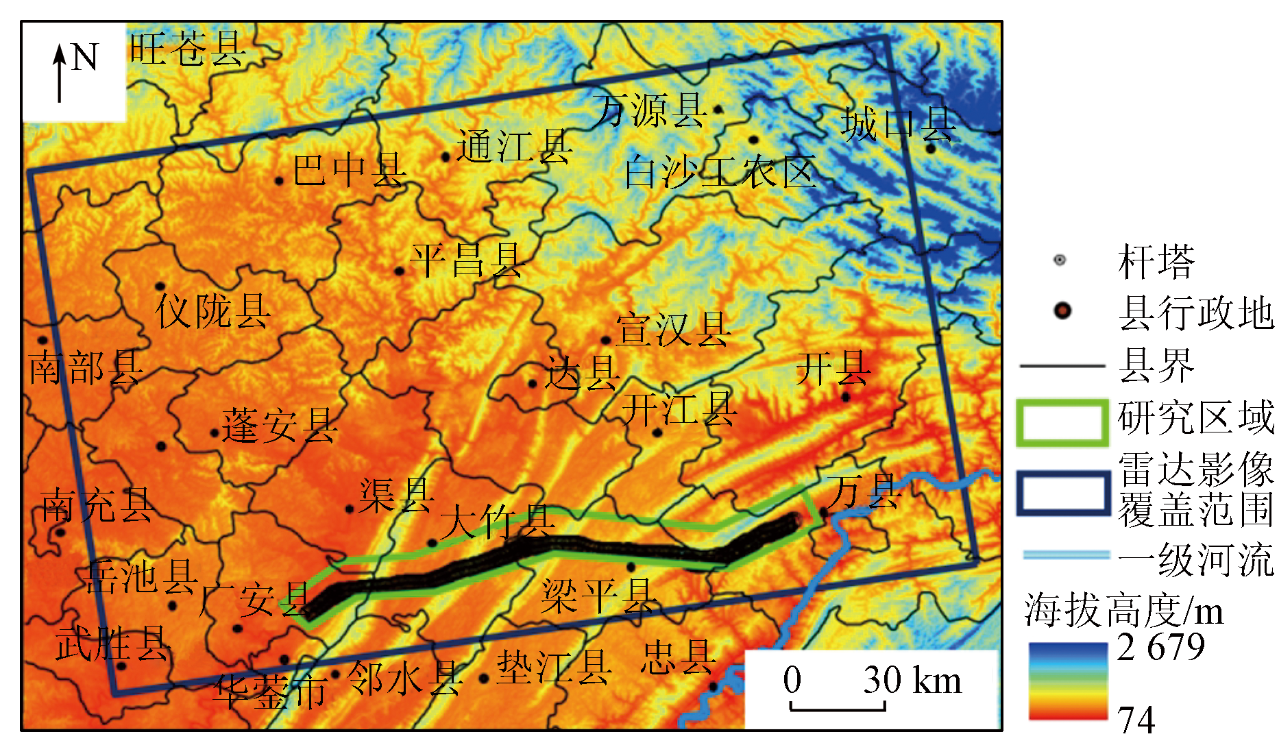
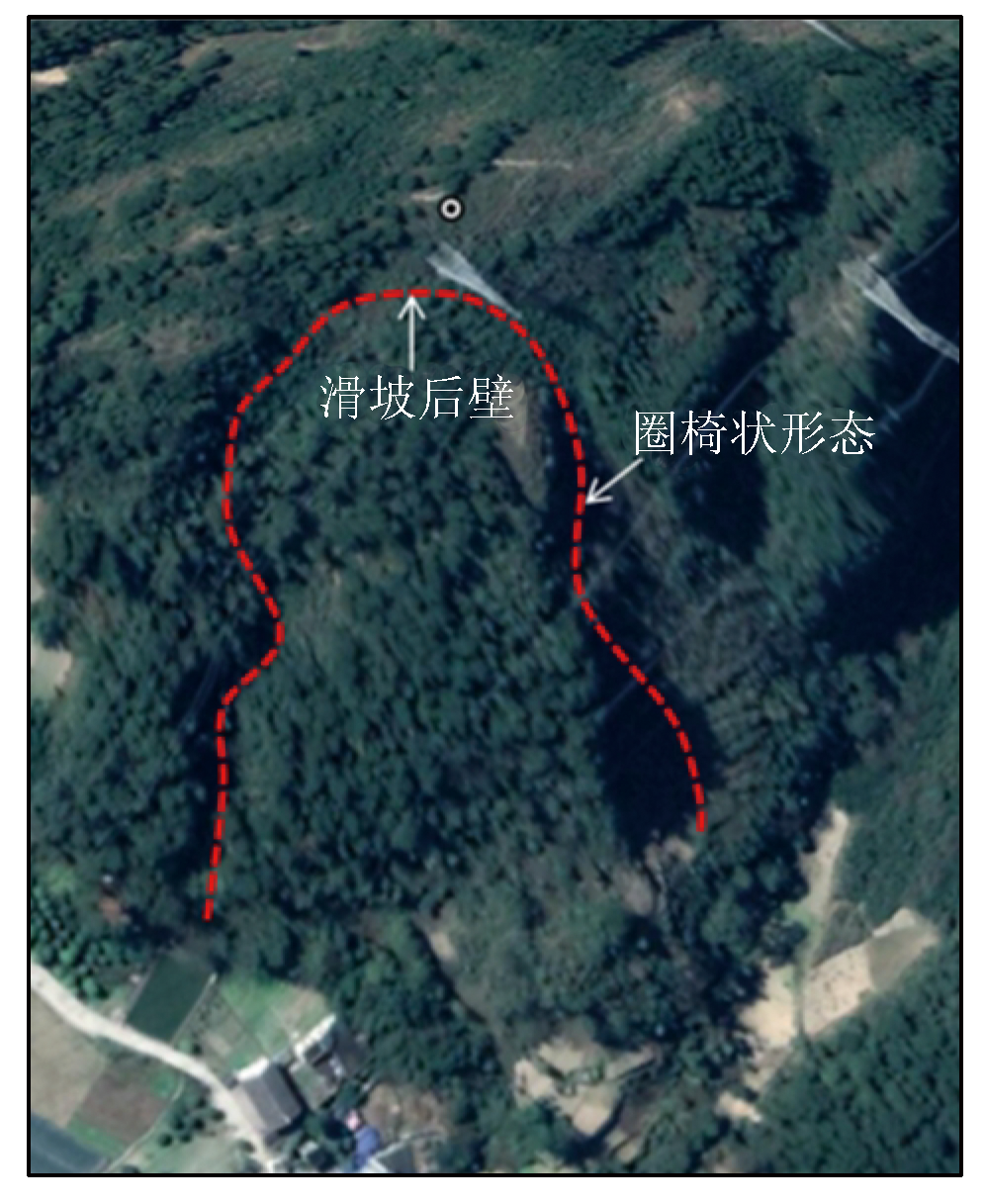
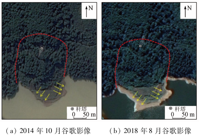
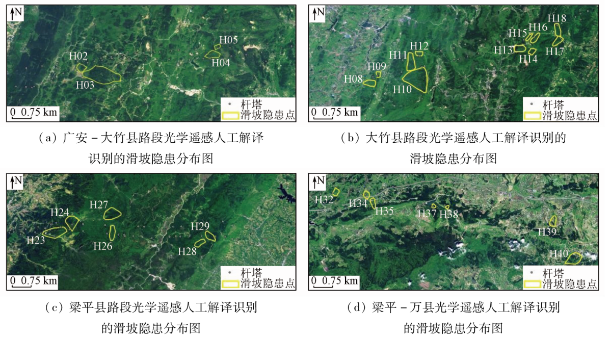
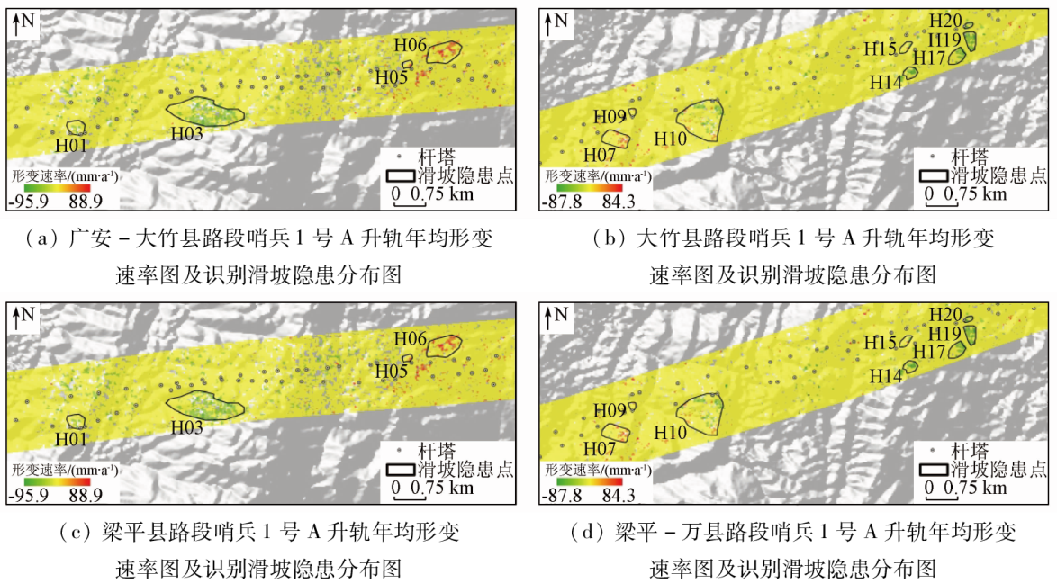
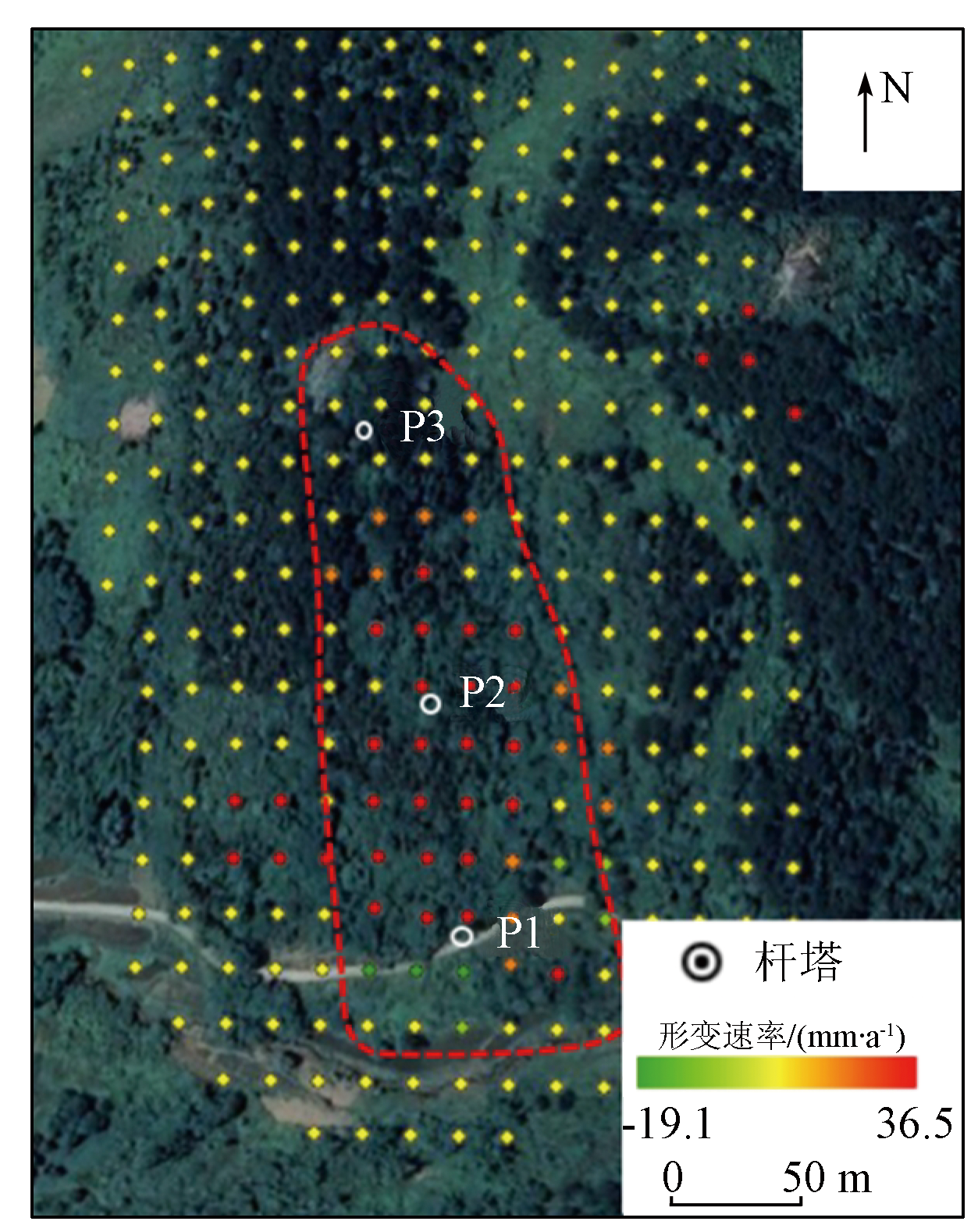
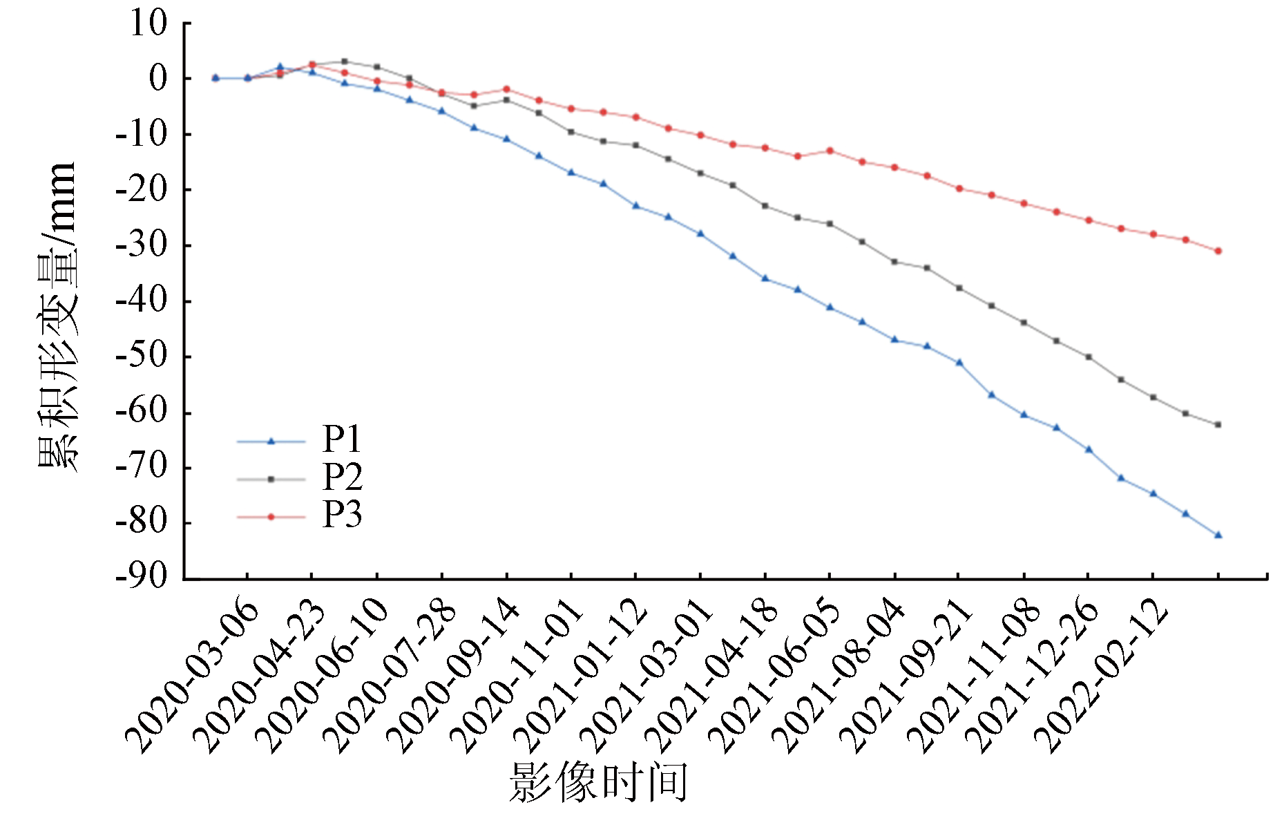
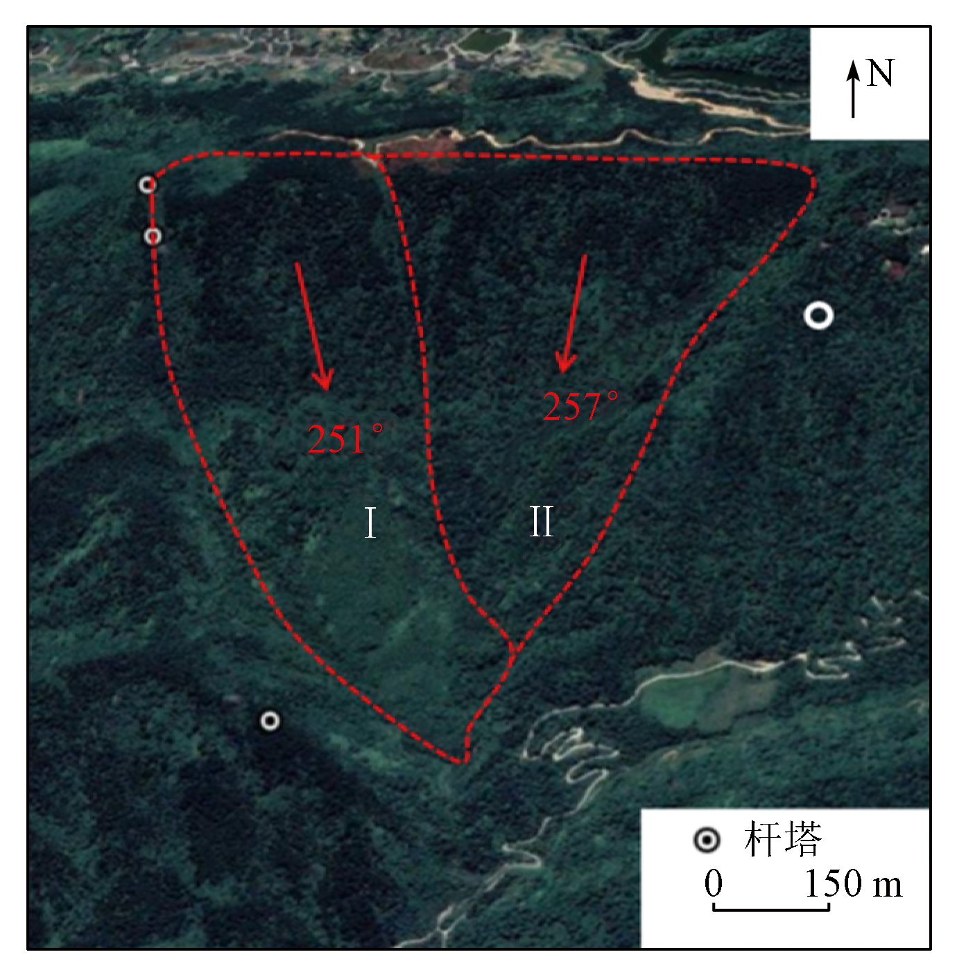
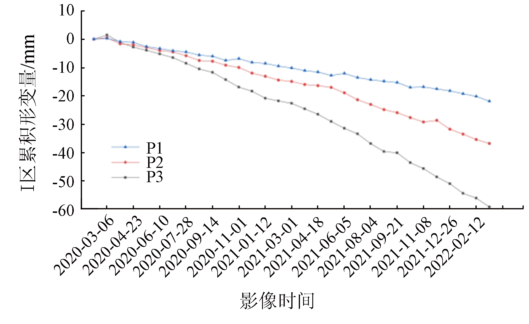
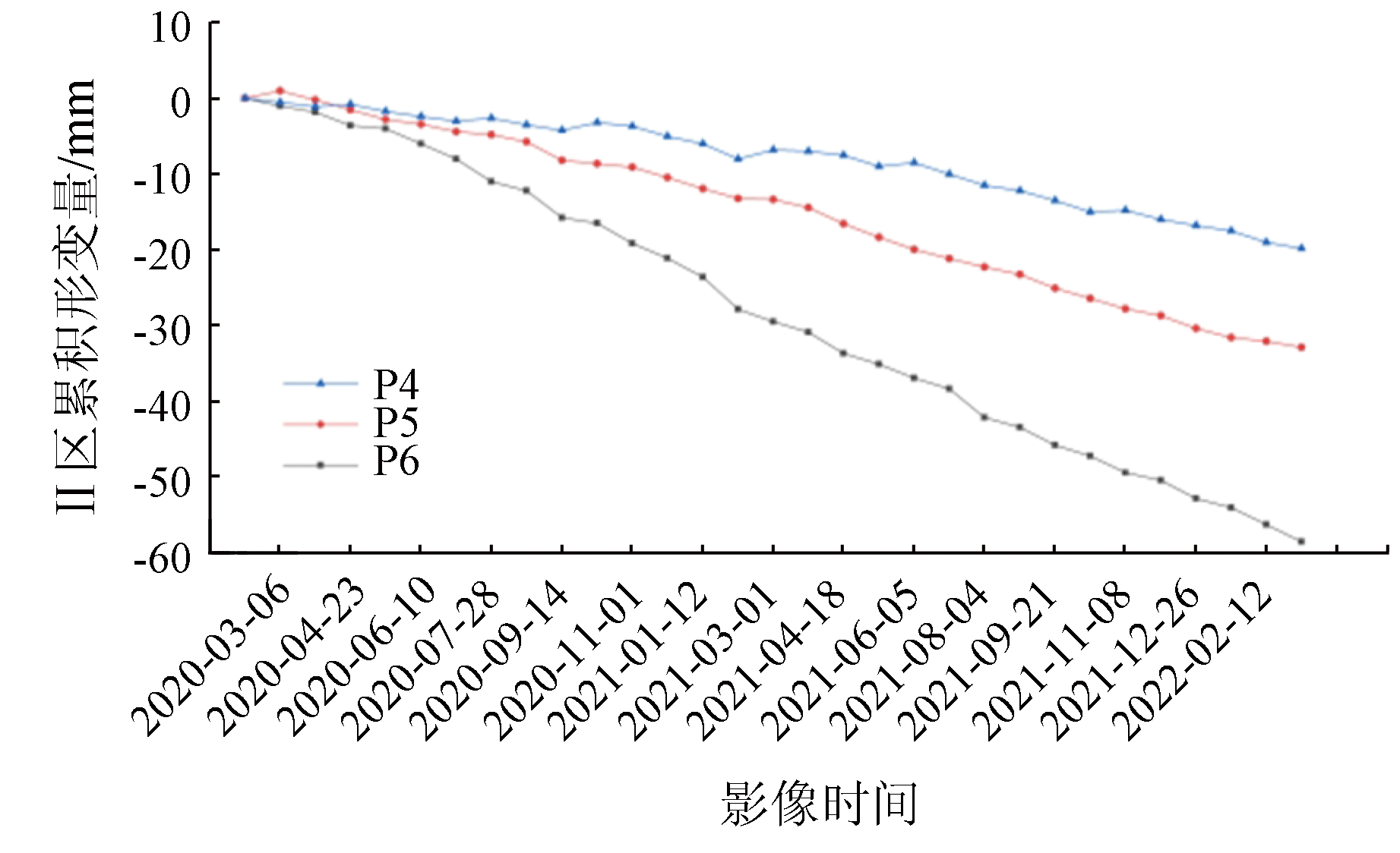
Power grid projects in mountainous regions have encountered numerous landslides in recent years, leading to collapsed transmission towers and power outages. Hence, early identification of potential landslides is crucial for ensuring the safety of power engineering. For this purpose, this study conducted early identification of potential landslides along the Sichuan-Chongqing power grid based on optical remote sensing and the small baseline subset (SBAS) - interferometric synthetic aperture radar (InSAR) technology. The interpretation of high-resolution optical remote sensing images revealed 28 potential landslide sites near the transmission towers along the power grid. Based on this, this study detected the study area’s surface deformation using the SBAS-InSAR technology, identifying 27 potential landslide sites. Except for 15 repeated results, the above two methods identified a total of 40 potential landslide sites. Finally, through field check and the qualitative analysis of deformation signs and stability, this study determined that seven potential landslide sites threaten the safety of transmission towers, with two of them presenting higher risks. These findings provide valuable guidance and references for the prevention and control of landslides along the Sichuan-Chongqing power grid.
Gao X X, Li S M, Chen P D, et al. Research on the instability mechanism of transmission towers under time-series InSAR slope slip monitoring[J]. Journal of Guizhou University(Natural Sciences), 2022, 39(1):43-50.
Dong J H, Ma Z G, Liang J T, et al. A comparative study of the identification of hidden landslide hazards based on time series InSAR techniques[J]. Remote Sensing for Natural Resources, 2022, 34(3):73-81.doi:10.6046/zrzyyg.2021333.
Ding H, Ding H. Application of remote sensing technology to interpretation of landslide disaster:A case study of Zichang County,Shanxi Province[J]. Journal of Natural Disasters, 2013, 22(2):229-233.
Dong X J, Wang D, Feng T. Research on the application of unmanned aerial vehicle digital photogrammetry in landslide disaster investigation[J]. Journal of Geological Hazards and Environment Preservation, 2019, 30(3):77-84.
Xu Q, Li W L, Dong X J, et al. The Xinmocun landslide on June 24,2017 in Maoxian,Sichuan:characteristics and failure mechanism[J]. Chinese Journal of Rock Mechanics and Engineering, 2017, 36(11):2612-2628.
[6]
张文君. 滑坡灾害遥感动态特征监测及其预测分析研究[D]. 成都: 西南交通大学, 2007.
Zhang W J. Research on the remote sensing dynamic character monitoring and prediction analysis of landslide disaster[D]. Chengdu: Southwest Jiaotong University, 2007.
Zhu Y F, Yao X, Yao L H, et al. Identification and risk assessment of coal mining-induced landslides in Guizhou Province by InSAR and optical remote sensing[J]. Journal of Geomechanics, 2022, 28(2):268-280.
[8]
Guo J M, Hu J Y, Li B, et al. Land Subsidence in Tianjin for 2015 to 2016 Revealed by the Analysis of Sentinel-1A with SBAS-InSAR[J]. Journal of Applied Remote Sensing, 2022, 11(2):026024.
doi: 10.1117/1.JRS.11.026024
Lu H Y, Li W L, Xu Q, et al. Early detection of landslides in the upstream and downstream areas of the baige landslide,the Jinsha River based on optical remote sensing and InSAR technologies[J]. Geomatics and Information Science of Wuhan University, 2019, 44(9):1342-1354.
Zhang L, Liao M S, Dong J, et al. Early detection of landslide hazards in mountainous areas of West China using time series SAR interferometry:A case study of Danba, Sichuan[J]. Geomatics and Information Science of Wuhan University, 2018, 43(12):2039-2049.
Nie C S. Recognition for potential landslides in Huidong County based on InSAR and optical remote sensing[D]. Beijing: China University of Geosciences(Beijing), 2021.
Xu Q, Dong X J, Li W L. Integrated space-air-ground early detection, monitoring and warning system for potential catastrophic geohazards[J]. Geomatics and Information Science of Wuhan University, 2019, 44(7):957-966.
Xu Q. Understanding and consideration of related issues in early identification of potential geohazards[J]. Geomatics and Information Science of Wuhan University, 2020, 45(11):1651-1659.
Ge D Q. Comprehensive application of remote sensing application in early identification,monitoring and early warning of geological disasters[J]. City and Disaster Reduction, 2018(6):53-60.
Ge D Q, Dai K R, Guo Z C, et al. Early identification of serious geological hazards with integrated remote sensing technologies: Thoughts and recommendations[J]. Geomatics and Information Science of Wuhan University, 2019, 44(7):949-956.
Ge D Q, Guo Z C. Thoughts on the application of comprehensive remote sensing in the early identification of hidden dangers of major geological disasters[J]. China Emergency Rescue, 2019(1):10-14.
Sha Y L, Wang X W, Liu G X, et al. SBAS-InSAR based monitoring and inversion of surface subsidence of the Shadunzi Coal Mine in Hami City,Xinjiang[J]. Remote Sensing for Natural Resources, 2021, 33(3):194-201.doi:10.6046/zrzyyg.2020026.
Liu P Y, Chang M, Wu B B, et al. Route selection of landslide prone area in Wenchuan section of Chengdu Wenchuan expressway based on SBAS-InSAR[J]. Earth Science, 2022, 47(6):2048-2057.
Zhang J Y, Zou Y X, Liu Q Y, et al. Potential landslides deformation monitoring in Bijie City with InSAR time series[J]. Bulletin of Surveying and Mapping, 2022(6):121-124.
doi: 10.13474/j.cnki.11-2246.2022.0183.
[21]
卓宝熙. 工程地质遥感判释与应用[M]. 北京: 中国铁道出版社, 2011.
Zhuo B X. Remote sensing interpretation & application of geology engineering[M]. Beijing: China Railway Publishing House, 2011.
Xu Z X, Ji M, Zhang G, et al. Method for dynamic prediction of mining subsidence based on the SBAS-InSAR technology and the logistic model[J]. Remote Sensing for Natural Resources, 2022, 34(2):20-29.doi:10.6046/zrzyyg.2021354.
[23]
Berardino P, Fornaro G, Lanari R, et al. A new algorithm for surface deformation monitoring based on small baseline differential SAR interferograms[J]. IEEE Transactions on Geoscience and Remote Sensing, 2002, 40(11):2375-2383.
doi: 10.1109/TGRS.2002.803792
 2023, Vol. 35
  ), 周林2, 谭明伦2, 汤明高1(