County-scale land use/land cover simulation based on multiple models
HE Suling1,2,3(), HE Zenghong1,2,3, PAN Jiya1,2,3, WANG Jinliang1,2,3()
1. Faculty of Geography, Yunnan Normal University, Kunming 650500, China 2. Key Laboratory of Resources and Environmental Remote Sensing for Universities in Yunnan, Kunming 650500, China 3. Center for Geospatial Information Engineering and Technology of Yunnan Province, Kunming 650500, China
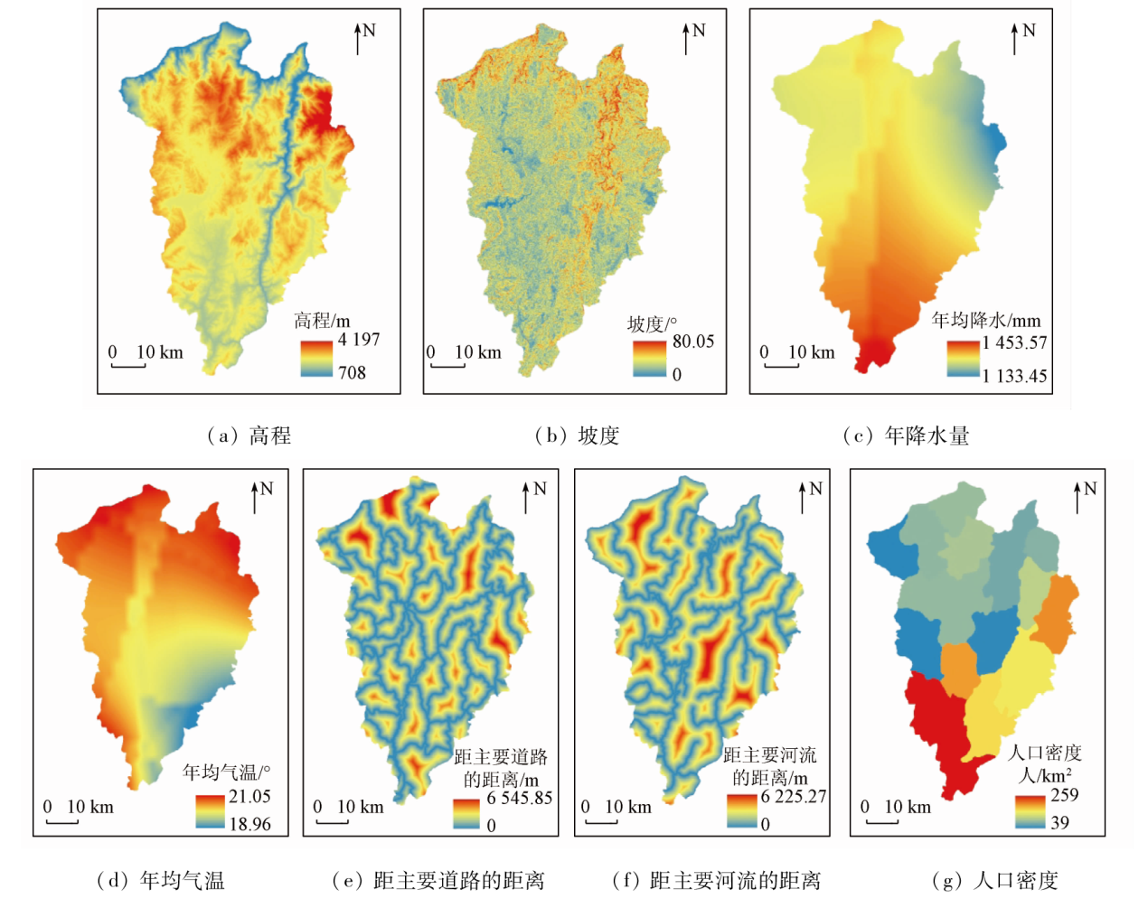
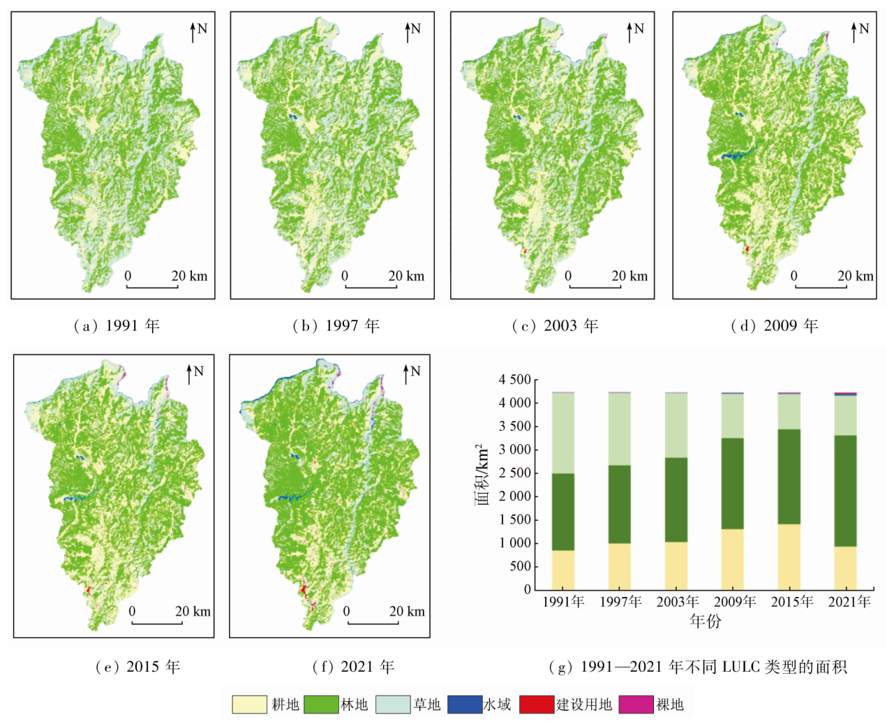
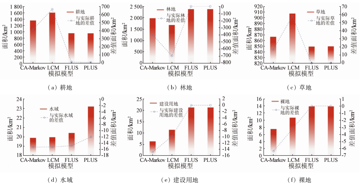
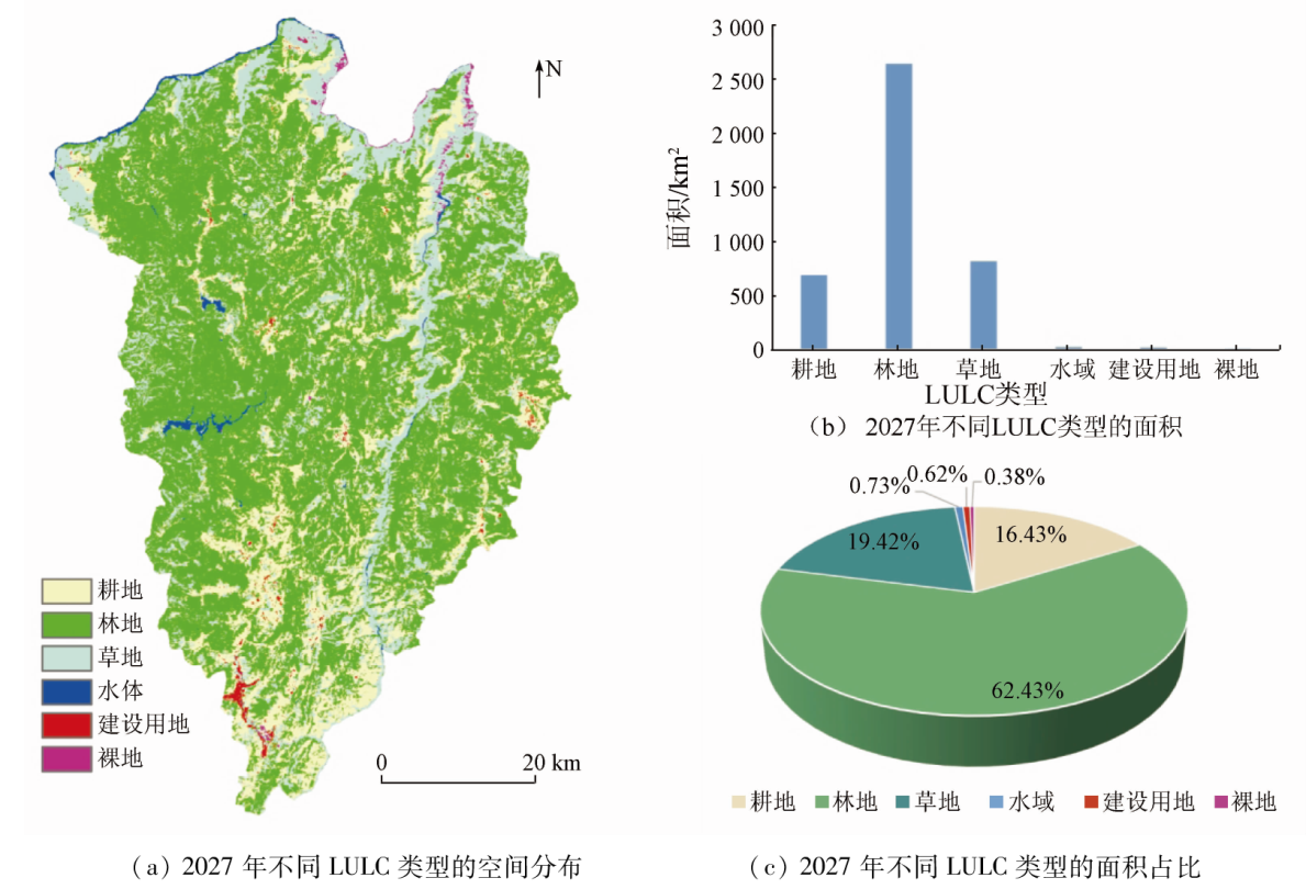
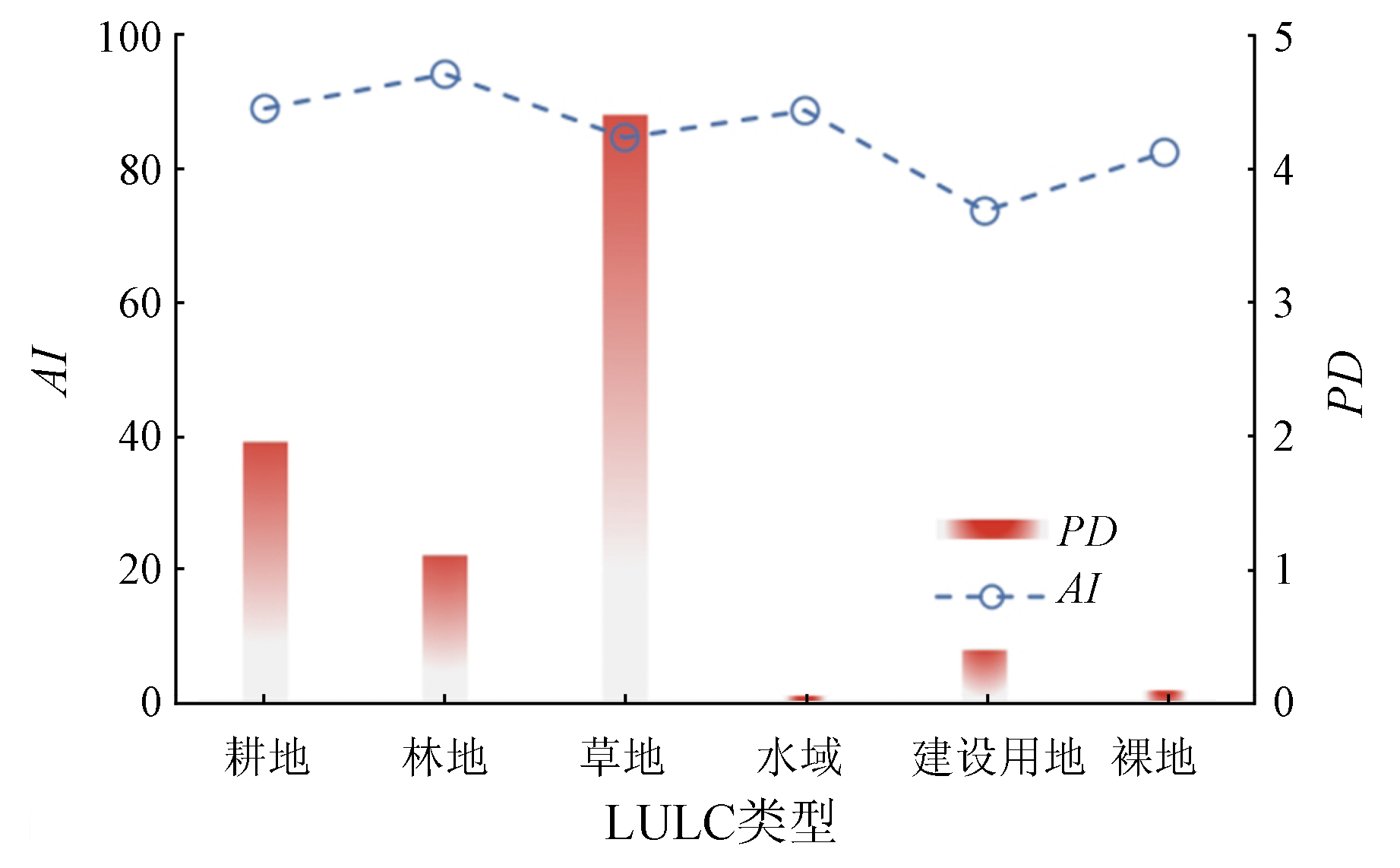
Land use/land cover (LULC) simulation is essential for research on changes in land use. Based on the Google Earth Engine (GEE) platform, this study extracted the high-precision LULC information of Luquan County from 1991 to 2021 and analyzed the spatio-temporal evolution pattern. Then, this study analyzed the factors driving LULC changes using a random forest model and compared the simulation results of Luquan County obtained using the cellular automata-Markov (CA-Markov), land change modeler (LCM), future land use simulation (FLUS), and patch-generating land use simulation (PLUS). Finally, this study forecast the LULC change scenario in Luquan County in 2027 using the optimal model. The results show that: ① From 1991 to 2021, the spatial LULC pattern of Luquan County was dominated by forestland, grassland, and farmland. The areas of farmland and waterbodies increased by 89.26 km2 and 27.72 km2, respectively, the areas of forestland, construction land, and bare land increased continuously by 724.25 km2, 21.08 km2, and 13.67 km2, respectively, and the grassland decreased at an annual average rate of 29.20 km2; ② The LULC in Luquan County was primarily influenced by topographic conditions (elevation and slope); ③ The simulation effects of the four LULC models were in the order of PLUS > FLUS > CA-Markov > LCM, with Kappa coefficient of 0.63, 0.58, 0.46 and 0.35, respectively and the overall accuracy of 0.78, 0.75, 0.66 and 0.58, respectively; ④ The spatial LULC pattern in Luquan County in 2027 will share similarities with that in 2021. From 2021 to 2027, the areas of farmland land, grassland, and water bodies will decrease at a rate of 40.21 km2/a, 4.51 km2/a, and 0.70 km2/a, respectively, while the forestland, construction land, and bare land will expand by 265.52 km2, 4.85 km2, and 2.08 km2, respectively.
何苏玲, 贺增红, 潘继亚, 王金亮. 基于多模型的县域土地利用/土地覆盖模拟[J]. 自然资源遥感, 2023, 35(4): 201-213.
HE Suling, HE Zenghong, PAN Jiya, WANG Jinliang. County-scale land use/land cover simulation based on multiple models. Remote Sensing for Natural Resources, 2023, 35(4): 201-213.
Li S Y, Liu X P, Li X, et al. Simulation model of land use dynamics and application:Progress and prospects[J]. Journal of Remote Sensing, 2017, 21(3):329-340.
[2]
Eastman J R. IDRISI Andes guide to GlS and image processing[M]. America: Clark University, Worcester, 2006,87-131.
[3]
Yang J, Su J, Chen F, et al. A local land use competition cellular automata model and its application[J]. ISPRS International Journal of Geo-Information, 2016, 5(7):106.
doi: 10.3390/ijgi5070106
[4]
Veldkamp A, Fresco L O. CLUE:A conceptual model to study the conversion of land use and its effects[J]. Ecological Modelling, 1996, 85(2/3):253-270.
doi: 10.1016/0304-3800(94)00151-0
[5]
Verburg P H, Soepboer W, Veldkamp A, et al. Modeling the spatial dynamics of regional land use:The CLUE- S model[J]. Environmental Management, 2002, 30(3):391-405.
pmid: 12148073
[6]
Liu X P, Liang X, Li X, et al. A future land use simulation model (FLUS) for simulating multiple land use scenarios by coupling human and natural effects[J]. Landscape and Urban Planning, 2017, 168:94-116.
doi: 10.1016/j.landurbplan.2017.09.019
[7]
Liang X, Guan Q F, Clarke K C, et al. Understanding the drivers of sustainable land expansion using a patch-generating land use simulation (PLUS) model:A case study in Wuhan,China[J]. Computers,Environment and Urban Systems, 2021, 85:101569.
doi: 10.1016/j.compenvurbsys.2020.101569
Lu W T, Dai C, Guo H C. Land use scenario design and simulation based on Dyna-CLUE model in Dianchi Lake Watershed[J]. Geographical Research, 2015, 34(9):1619-1629.
doi: 10.11821/dlyj201509002
[9]
Sakayarote K, Shrestha R P. Simulating land use for protecting food crop areas in northeast Thailand using GIS and Dyna-CLUE[J]. Journal of Geographical Sciences, 2019, 29(5):803-817.
doi: 10.1007/s11442-019-1629-7
[10]
Chen Z Z, Huang M, Zhu D Y, et al. Integrating remote sensing and a Markov-FLUS model to simulate future land use changes in Hokkaido,Japan[J]. Remote Sensing, 2021, 13(13):2621.
doi: 10.3390/rs13132621
[11]
Darvishi A, Yousefi M, Marull J. Modelling landscape ecological assessments of land use and cover change scenarios.Application to the Bojnourd Metropolitan Area (NE Iran)[J]. Land Use Policy, 2020, 99:105098.
doi: 10.1016/j.landusepol.2020.105098
Lin Y L, Zhao J S, Chen G P, et al. Optimization of regional territory space pattern based on MCR-FLUS-Markov model[J]. Transactions of the Chinese Society for Agricultural Machinery, 2021, 52(4):159-170,207.
Cui W L, Cai L, Xi H H, et al. Ecological security assessment and multi-scenario simulation analysis of Zhejiang Greater Bay Area based on LUCC[J]. Acta Ecologica Sinica, 2022, 42(6): 2136-2148.
Lin L, Fan H, Jin Y. Multi-scale and multi-model simulation of land use/ land cover change in the mountainous county:A case study of Mengla County in Yunnan Province,China[J]. Mountain Research, 2020, 38(4):630-642.
Yang J D, Ou X K, Guo J W, et al. Comparison of CA-Markov and geomod models for rubber plantation prediction[J]. Mountain Research, 2014, 32(3):267-276.
Chen K X, Cong P F, Lu W Z, et al. Comparison of the CA-Markov and LCM models in simulating wetland change in the Yellow River Delta[J]. Journal of Geo-information Science, 2019, 21(12):1903-1910.
[17]
Wang J, Zhang J P, Xiong N N, et al. Spatial and temporal variation,simulation and prediction of land use in ecological conservation area of western Beijing[J]. Remote Sensing, 2022, 14(6):1452.
doi: 10.3390/rs14061452
Zhao X B. Consolidate and enhance the achievements of industrial poverty alleviation and the revitalization of rural industries effective connection:A case of study of Luquan County,Kunming[D]. Kunming: Yunnan Normal University, 2022.
Rao K. A study on the land ecological security evaluation of typical mountain and canyon ecologically fragile counties:A case study of Luquan Yi and Miao Autonomous County in Yunnan Province[D]. Kunming: Yunnan university of finance and economics, 2020.
[20]
Li J, Wang J L, Zhang J, et al. Growing-season vegetation coverage patterns and driving factors in the China-Myanmar Economic Corridor based on Google Earth Engine and geographic detector[J]. Ecological Indicators, 2022, 136:108620.
doi: 10.1016/j.ecolind.2022.108620
Zuo Q, Zhou Y, Li Q, et al. Analysis of spatial and temporal changes and trajectory characteristics of land use pattern in the southwest Hubei[J]. Journal of Soil and Water Conservation, 2022, 36(1):161-169.
Xu X L, Liu J Y, Zhang S W, et al. Multi period remote sensing monitoring data set of land use and land cover in China (CNLUCC)[EB/OL]. Data Registration and Publishing System of Institute of Geographic Sciences and Resources,Chinese Academy of Sciences (http://www.resdc.cn/DOI ), 2018.
[23]
Yang J, Huang X. The 30 m annual land cover dataset and its dynamics in China from 1990 to 2019[J]. Earth System Science Data, 2021, 13(8): 3907-3925.
doi: 10.5194/essd-13-3907-2021
[24]
Jun C, Ban Y F, Li S N. China:Open access to Earth land-cover map[J]. Nature, 2014, 514(7523): 434.
[25]
Liu C L, Li W L, Zhu G F, et al. Land use/land cover changes and their driving factors in the northeastern Tibetan Plateau based on geographical detectors and Google earth engine: A case study in Gannan prefecture[J]. Remote Sensing, 2020, 12:3139.
doi: 10.3390/rs12193139
[26]
Zhai R T, Zhang C R, Li W D, et al. Evaluation of driving forces of land use and land cover change in new England area by a mixed method[J]. ISPRS International Journal of Geo-Information, 2020, 9(6):350.
doi: 10.3390/ijgi9060350
Li L H, Liu X P, Ou J P, et al. Spatio-temporal changes and mechanism analysis of urban 3D expansion based on random forest model[J]. Geography and Geo-Information Science, 2019, 35(2):53-60.
Guo P, Zhou W, Yuan T, et al. Analysis on the temporal and spatial change of land use and its driving factors of declining resources-based city[J]. Research of Soil and Water Conservation, 2016, 23(4):191-198.
Wang X D, Yao Y, Ren S L, et al. A coupled FLUS and Markov approach to simulate the spatial pattern of land use in rapidly developing cities[J]. Journal of Geo-information Science, 2022, 24(1):100-113.
Tian J, Guo S L, Liu D D, et al. Impacts of climate and land use/cover changes on runoff in the Hanjiang River Basin[J]. Acta Geographica Sinica, 2020, 75(11):2307-2318.
doi: 10.11821/dlxb202011003
Li J L, Liu H, Ha S N, et al. Simulation of land use and evaluation of ecosystem service value in Daihai Basin[J]. Chinese Journal of Ecology, 2022, 41(2):343-350.
Zheng Q H, Luo G P, Zhu L, et al. Prediction of landscape patterns in Ili River Delta based on CA-Markov model[J]. Chinese Journal of Applied Ecology, 2010, 21(4):873-882.
Lin M Z, Liu H Y, Zhou R B, et al. Evaluation and trade-offs of ecosystem services in Guangdong-Hong Kong-Macao Greater Bay Area under multi-scenario simulation[J]. Geographical Research, 2021, 40(9):2657-2669.
doi: 10.11821/dlyj020200943
Wang J N, Zhang Z. Land use change and simulation analysis in the northern margin of the Qaidam Basin based on Markov-PLUS model[J]. Journal of Northwest Forestry University, 2022, 37(3):139-148,179.
[35]
Zheng W, Shen Q P, Wang H, et al. Simulating land use change in urban renewal areas:A case study in Hong Kong[J]. Habitat International, 2015, 46: 23-34.
doi: 10.1016/j.habitatint.2014.10.008
Fu Y J, Shi X Y, He J. The spatio-temporal evolution characteristics of landscape fragmentation in Fenhe River Basin[J]. Journal of Natural Resources, 2019, 34(8):1606-1619.
doi: 10.31497/zrzyxb.20190804
Liu S L, An N N, Hou X Y, et al. Spatio-temporal dynamics of landscape fragmentation and its influencing analysis in the downstream of Lancang River Basin[J]. Ecology and Environmental Sciences, 2018, 27(7):1351-1358.
Shao D W, Wu D M. Analysis on the effect of landscape fragmentation on ecosystem service value:A case study of Suzhou[J]. Resources and Environment in the Yangtze Basin, 2020, 29(11):2436-2449.
Liang J L, Chen W X, Li J F, et al. Spatiotemporal patterns of landscape fragmentation and causes in the Yellow River Basin[J]. Acta Ecologica Sinica, 2022, 42(5):1993-2009.
 2023, Vol. 35
  ), 贺增红1,2,3, 潘继亚1,2,3, 王金亮1,2,3(