Collaborative monitoring of abandoned arable land in cloudy and rainy areas based on multisource remote sensing data
XIAO Wenju1(), YANG Yingpin1, WU Zhifeng1,2,3()
1. School of Geography and Remote Sensing, Guangzhou University, Guangzhou 510006, China 2. Southern Marine Science and Engineering Guangdong Laboratory (Guangzhou), Guangzhou 511458, China 3. MNR Key Laboratory for Geo-Environmental Monitoring of Great Bay Area, Shenzhen 518060, China
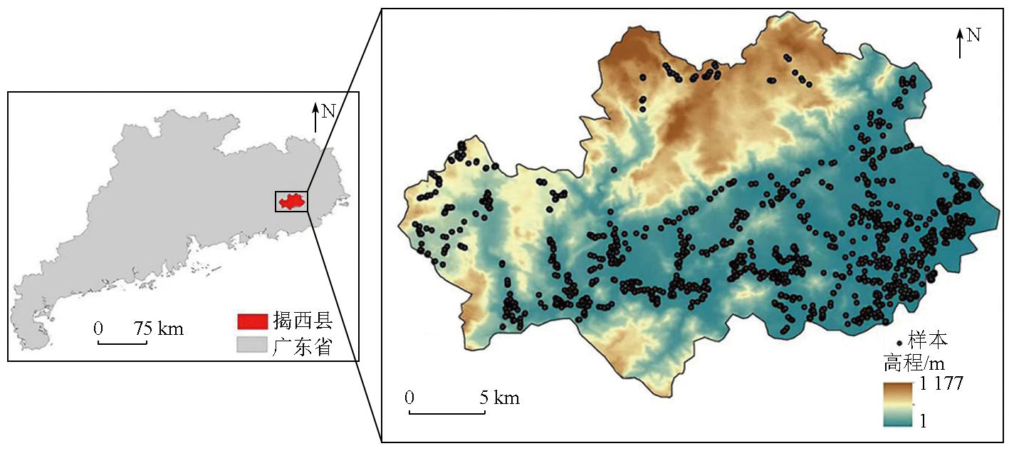
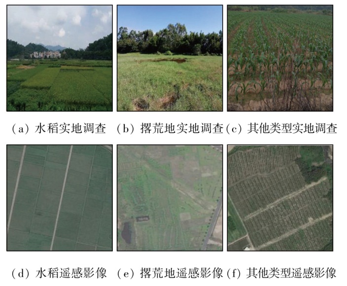
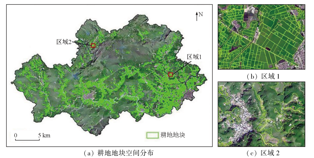
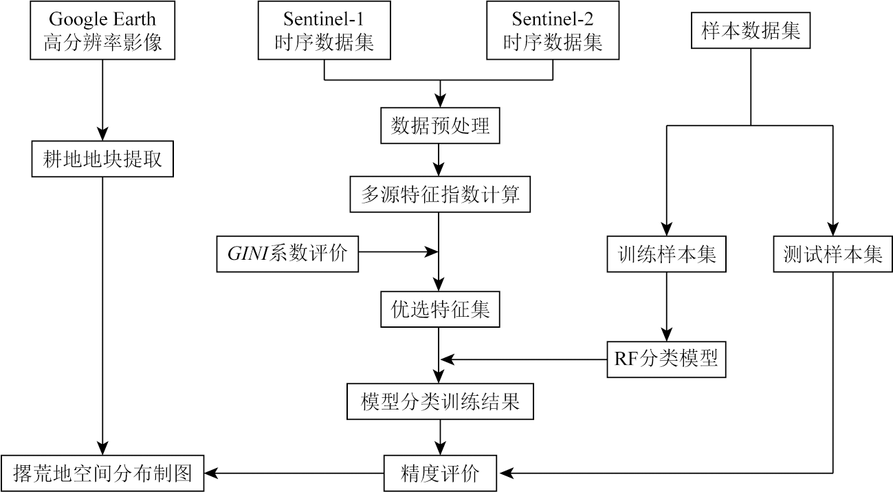
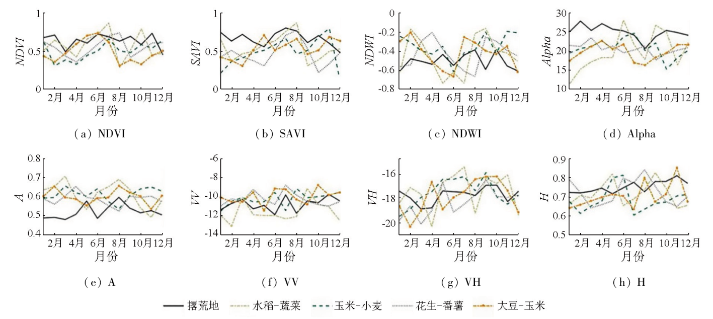
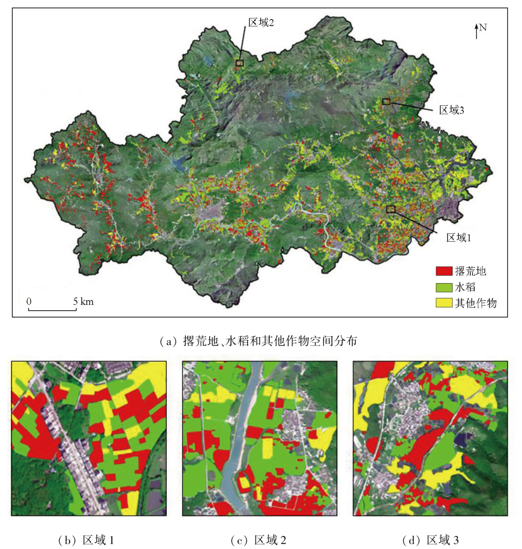
In cloudy and rainy areas, the humid and hot climate and cloud contamination during the rainy season often cause the loss of optical data. Hence, optical data alone fail to enable the accurate monitoring of abandoned land. This study proposed a method for monitoring abandoned land in cloudy and rainy areas based on multisource remote sensing data. By integrating optical and synthetic aperture Radar (SAR) remote sensing data, this study extracted the multitemporal optical and SAR-derived features of vegetation and assessed their importance using the GINI index. Employing the random forest classifier, this study mapped the spatial distribution of abandoned land in Jiexi County in 2021. The results show that the proposed method achieved a relatively high accuracy in identifying abandoned land in cloudy and rainy areas, yielding an overall accuracy of 87.0%. This value represents an improvement of 6.7 and 13.8 percentage points, respectively, compared to the results derived solely from optical and SAR remote sensing features. The analysis reveals that the normalized difference vegetation index (NDVI), soil-adjusted vegetation index (SAVI), polarization entropy, normalized difference water index (NDWI), and anti-entropy are crucial for identifying abandoned land. Additionally, key months for distinguishing abandoned from non-abandoned land include February, April, June, August, and December. This study establishes a monitoring model for abandoned land based on multisource features and multitemporal phases, providing technical support for monitoring abandoned land in cloudy and rainy areas.
肖文菊, 杨颖频, 吴志峰. 多云多雨区耕地撂荒多源遥感协同监测[J]. 自然资源遥感, 2025, 37(2): 39-48.
XIAO Wenju, YANG Yingpin, WU Zhifeng. Collaborative monitoring of abandoned arable land in cloudy and rainy areas based on multisource remote sensing data. Remote Sensing for Natural Resources, 2025, 37(2): 39-48.
Chen X Y, Zheng G Q. Research progress of cultivated land abandonment at home and abroad[J]. China Population,Resources and Environment, 2018, 28(s2):37-41.
Yang T, Guo X D, Yu X, et al. Review on monitoring methods and ecological impact of abandoned agricultural land[J]. Ecology and Environmental Sciences, 2020, 29(8):1683-1692.
Zhou X J. Application of remote sensing monitoring in abandoned arable land in a hilly region[J]. Remote Sensing for Natural Resources, 2024, 36(1):235-241.doi:10.6046/zrzyyg.2022435.
Luo Y H, Gong J Z, Li T X, et al. Extraction of abandoned farmland based on MaxEnt model:A case study of Wusheng County,Sichuan Province[J]. Journal of Agricultural Resources and Environment, 2021, 38(6):1084-1093.
Yang Y P, Wu Z F, Luo J C, et al. Parcel-based crop distribution extraction using the spatiotemporal collaboration of remote sensing data[J]. Transactions of the Chinese Society of Agricultural Engineering, 2021, 37(7):166-174.
Qian L S, Jiang H, Chen S S, et al. Extracting field-scale crop distribution in Lingnan using spatiotemporal filtering of Sentinel-1 time-series data[J]. Transactions of the Chinese Society of Agricultural Engineering, 2022, 38(5):158-166.
Ma L, Xu X G, Liu L Y, et al. Study on crops classification based on multi-temporal NDVI and characteristic bands[J]. Remote Sensing Technology and Application, 2008, 23(5):520-524.
Liu J, Liu J K, An J J, et al. Precise crop classification based on multi-features from time-series Landsat8 OLI images and random forest algorithm[J]. Agricultural Research in the Arid Areas, 2020, 38(3):281-288,298.
Lin Z H, Mo X G. Phenologies from harmonics analysis of AVHRR NDVI time series[J]. Transactions of the Chinese Society of Agricultural Engineering, 2006, 22(12):138-144.
Du B J, Zhang J, Wang Z M, et al. Crop mapping based on Sentinel-2A NDVI time series using object-oriented classification and decision tree model[J]. Journal of Geo-Information Science, 2019, 21(5):740-751.
Wang L Y, Zhou Z F, Zhao X, et al. Spatiotemporal evolution of Karst rocky desertification abandoned cropland based on farmland-parcels time-series remote sensing[J]. Journal of Soil and Water Conservation, 2020, 34(1):92-99,107.
Song X Q, Liang Z X, Zhou H Y, et al. An updated method to monitor the changes in spatial distribution of abandoned land based on decision tree and time series NDVI change detection:A case study of Puge County,Liangshan Prefecture,Sichuan Province,China[J]. Mountain Research, 2021, 39(6):912-921.
Yang T, Guo X D, Yu X, et al. Driving force and model simulation of farmland abandonment in village scale based on multisource data[J]. Journal of Arid Land Resources and Environment, 2019, 33(11):62-69.
[15]
Meijninger W, Elbersen B, van Eupen M, et al. Identification of early abandonment in cropland through radar-based coherence data and application of a Random-Forest model[J]. GCB Bioenergy, 2022, 14(7):735-755.
Wang C C, Wang Y Q, Wang L H. Crop identification based on SAR texture information:A case study of Nong’an County[J]. Remote Sensing Technology and Application, 2021, 36(2):372-380.
[17]
Luo C, Qi B, Liu H, et al. Using time series sentinel-1 images for object-oriented crop classification in Google Earth Engine[J]. Remote Sensing, 2021, 13(4):561.
[18]
Xu L, Zhang H, Wang C, et al. Crop classification based on temporal information using sentinel-1 SAR time-series data[J]. Remote Sensing, 2018, 11(1):53.
[19]
Yang Y, Wu Z, Xiao W, et al. Abandoned land mapping based on spatiotemporal features from PolSAR data via deep learning methods[J]. Remote Sensing, 2023, 15(16):3942.
Zhang H, Gao X H, Shi F F, et al. Sentinel-2 MSI and Sentinel-1 SAR based information extraction of abandoned land in the western Loess Plateau:A case study of Minhe County in Qinghai[J]. Remote Sensing for Natural Resources, 2022, 34(4):144-154.
[21]
Bucha T, Papčo J, Sačkov I, et al. Woody above-ground biomass estimation on abandoned agriculture land using Sentinel-1 and Sentinel-2 data[J]. Remote Sensing, 2021, 13(13):2488.
Xiao G F, Zhu X F, Hou C Y, et al. Extraction and analysis of abandoned farmland:A case study of Qingyun and Wudi Counties in Shandong Province[J]. Acta Geographica Sinica, 2018, 73(9):1658-1673.
[23]
Song W. Mapping cropland abandonment in mountainous areas using an annual land-use trajectory approach[J]. Sustainability, 2019, 11(21):5951.
Liu R Q, Li J L, Sun C, et al. Classification of Yancheng coastal wetland vegetation based on vegetation phenological characteristics derived from Sentinel-2 time-series[J]. Acta Geographica Sinica, 2021, 76(7):1680-1692.
doi: 10.11821/dlxb202107008
[25]
Portalés-Julià E, Campos-Taberner M, García-Haro F J, et al. Assessing the Sentinel-2 capabilities to identify abandoned crops using deep learning[J]. Agronomy, 2021, 11(4):654.
[26]
Luo C, Liu H J, Lu L P, et al. Monthly composites from Sentinel-1 and Sentinel-2 images for regional major crop mapping with Google Earth Engine[J]. Journal of Integrative Agriculture, 2021, 20(7):1944-1957.
Shi X, Ming Y F, Liu C X, et al. Analysis on the application of time series image in extraction of winter wheat planting area[J]. Radio Engineering, 2021, 51(12):1567-1576.
 2025, Vol. 37
  ), 杨颖频1, 吴志峰1,2,3(