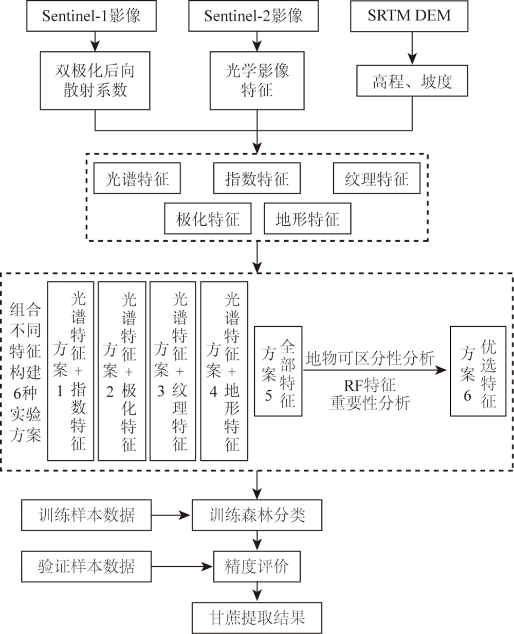
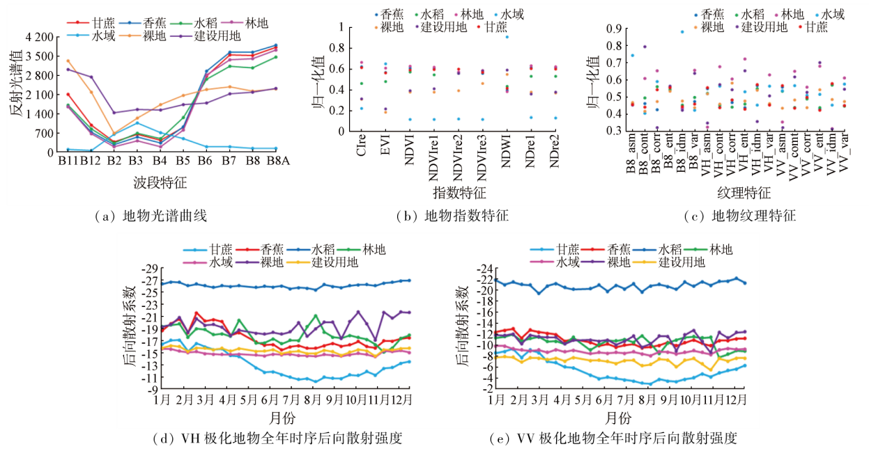
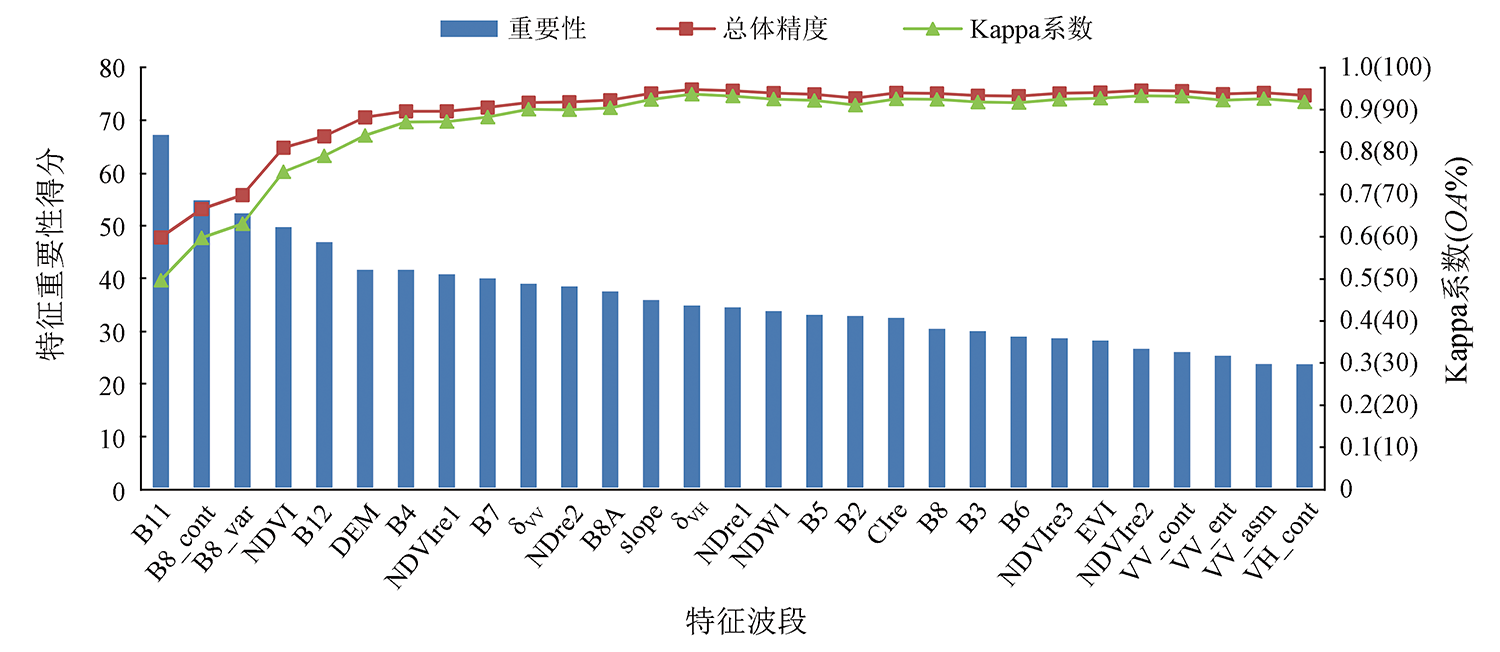
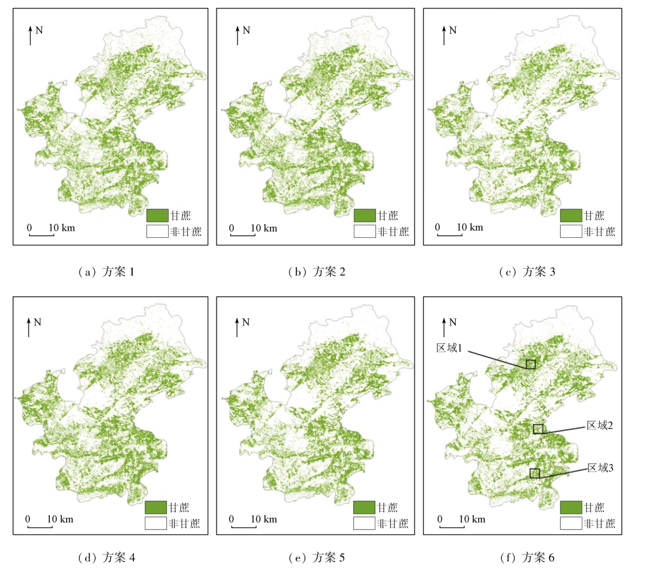
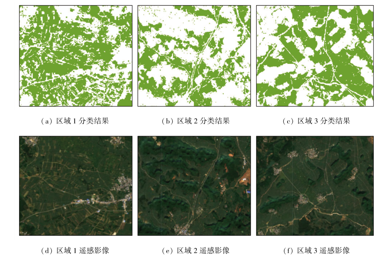
The integration of multi-source remote sensing images and multi-feature parameters is effective in the accurate identification of target ground objects. However, excess feature parameters can cause data redundancy, reducing classification accuracy. Focusing on a sugarcane planting area with Karst landforms, this study extracted the spectral, index, texture, topographic, and polarization features of the ground objects in the study area from Sentinel-1/2 images and SRTM digital elevation data. The index features involved the red edge index calculated based on the red-edge band, which was scarce in data derived from remote sensing sensors, and the texture features included the Radar image textures. In the experiment, six schemes were designed to explore the effects of different image features and the random forest-based optimal feature association on sugarcane information extraction. The results show that for the classification of ground objects in the study area using spectral features combined with other feature types, the importance of the feature types ranked in descending order of spectral features, index features, texture features, topographic features, and polarization features. Among the six schemes, the scheme based on the random forest algorithm, integrating different feature variables, yielded the optimal information extraction effect for sugarcane, with both user and producer accuracy higher than 97%, overall accuracy of 95.49%, and a Kappa coefficient of 0.94.
卢献健, 张焕铃, 晏红波, 黎振宝, 郭子扬. 协同Sentinel-1/2多特征优选的甘蔗提取方法[J]. 自然资源遥感, 2024, 36(1): 86-94.
LU Xianjian, ZHANG Huanling, YAN Hongbo, LI Zhenbao, GUO Ziyang. A method for sugarcane information extraction based on multi-feature optimal selection of Sentinel-1/2 image data. Remote Sensing for Natural Resources, 2024, 36(1): 86-94.
Xie X C, Yang Y C, Tian Y, et al. Sugarcane planting area and growth monitoring based on remote sensing in Guangxi[J]. Chinese Journal of Eco-Agriculture, 2021, 29(2):410-422.
Qin Z L, Xie G X, Li Y X, et al. Application of multi-temporal GF-1 image in extraction of staple crops in hilly region[J]. Journal of Southern Agriculture, 2017, 48(1):181-188.
Yang Y G, Liu P, Zhang H B, et al. Research on GF-2 image classification based on feature optimization random forest algorithm[J]. Spacecraft Recovery and Remote Sensing, 2022, 43(2):115-126.
Yu F, Lyu Z, Sui Z W, et al. Extraction of rice information using multi-temporal SAR data based on feature optimization[J]. Transactions of the Chinese Society for Agricultural Machinery, 2023, 54(3):259-265,327.
Yuan X. Monitoring of sugarcane based on time series of Sentinel data:A case study of Chongzuo,Guangxi[D]. Xi’an: Xi’an University of Science and Technology, 2019.
Wang J L, Huang J L, Wang L H, et al. Identification of sugarcane based on object-oriented analysis using time-series HJ CCD data[J]. Transactions of the Chinese Society of Agricultural Engineering, 2014, 30(11):145-151.
[8]
Virnodkar S, Pachghare V K, Patil V C, et al. Performance evaluation of RF and SVM for sugarcane classification using Sentinel-2 NDVI time-series[C]//Ponigrahi CR,Pati B,Mohapatra P,et al.Progress in Advanced Computing and Intelligent Engineering.Singapore:Springer,2021:163-174
Wang R, Zhao H L, Jiang Y Z, et al. Application and analyses of texture features based on GF-1 WFV images in monthly information extraction of crops[J]. Remote Sensing for Natural Resources, 2021, 33(3):72-79.doi:10.6046/zrzyyg.2020334.
Xiang H Y, Luo H X, Liu G P, et al. Land cover classification in mountain areas based on Sentinel-1A polarimetric SAR data and object oriented method[J]. Journal of Natural Resources, 2017, 32(12):2136-2148.
Zhang M R, Feng Z L. Research on GF-6 image land use classification method under feature optimization[J]. Henan Science and Technology, 2022, 41(11):106-110.
Zha D P, Cai H S, Zhang X L, et al. Extraction of paddy fields using multi-temporal Sentinel-1 images[J]. Remote Sensing for Natural Resources, 2022, 34(3): 184-195.doi:10.6046/zrzyyg.2021320.
Wang D J, Jiang Q G, Li Y H, et al. Land use classification of farming areas based on time series Sentinel-2A/B data and random forest algorithm[J]. Remote Sensing for Land and Resources, 2020, 32(4):236-243.doi:10.6046/gtzyyg.2020.04.29.
Qin Z L, Li G X, Xie Y X, et al. Application of multi-temporal GF-1 image in extraction of staple crops in hilly region[J]. Journal of Southern Agriculture, 2017, 48(1):181-188.
Wang X Y, Lyu Z, Yuan Z, et al. Review on the application of red edge band optical remote sensing satellite red edge band[J]. Satellite Application, 2023(2):48-53.
Zhao Y, Jiang M. Integration of SAR polarimetric parameters and multi-spectral data for object based land cover classification[J]. Acta Geodaetica et Cartographica Sinica, 2019, 48(5):609-617.
Guo J, Zhu L, Jin B. Crop classification based on data fusion of Sentinel-1 and Sentinel-2[J]. Transactions of the Chinese Society for Agricultural Machinery, 2018, 49(4):192-198.
Zhang H, Gao X H, Shi F F, et al. Sentinel-2 MSI and Sentinel-1 SAR based information extraction of abandoned land in the western Loess Plateau:A case study of Minhe County in Qinghai[J]. Remote Sensing for Natural Resources, 2022, 34(4):144-154.doi:10.6046/zrzyyg.2021385.
Liu C T, Feng Q L, Jin D J, et al. Application of random forest and Sentinel-1/2 in the information extraction of impervious layers in Dongying City[J]. Remote Sensing for Natural Resources, 2021, 33(3):253-261.doi:10.6046/zrzyyg.2020310
[20]
Wang Y Y, Fang S H, Zhao L L, et al. Parcel-based summer maize mapping and phenology estimation combined using Sentinel-2 and time series Sentinel-1 data[J]. International Journal of Applied Earth Observation and Geoinformation, 2022, 108:102720.
doi: 10.1016/j.jag.2022.102720
Wang L H, Jin H H, Wang C C, et al. Backscattering characteristics and texture information analysis of typical crops based on synthetic aperture Radar:A case study of Nong’an County,Jilin Province[J]. Chinese Journal of Eco-Agriculture, 2019, 27(9):1385-1393.
Zhai P F, Li S H, Hu Y M. Object-oriented land cover change detection combining optical and Radar remote sensing data[J]. Transactions of the Chinese Society of Agricultural Engineering, 2021, 37(23):216-224.
[23]
Breiman L. Random forests[J]Machine Learning. 2001, 45(1):5-32.
doi: 10.1023/A:1010933404324
Li H K, Wang L J, Xiao S S. Random forest classification of land use in hilly and mountaineous areas of Southern China using multi-source remote sensing data[J]. Transactions of the Chinese Society of Agricultural Engineering, 2021, 37(7):244-251.
Zhang L, Gong Z N, Wang Q W, et al. Wetland mapping of Yellow River Delta wetlands based on multi-feature optimization of Sentinel-2 images[J]. Journal of Remote Sensing, 2019, 23(2):313-326.
[26]
Stehman S V. Selecting and interpreting measures of thematic classification accuracy[J]. Remote Sensing of Environment, 1997, 62(1):77-89.
doi: 10.1016/S0034-4257(97)00083-7
 2024, Vol. 36
  ), 张焕铃, 晏红波(