1. Geological Exploration Technology Institute of Jiangsu Province, Nanjing 210049, China 2. Jiangsu Province Engineering Research Center of Airborne Detecting and Intelligent Perceptive Technology, Nanjing 210049, China 3. Nanjing University of Science & Technology, Nanjing 210094, China
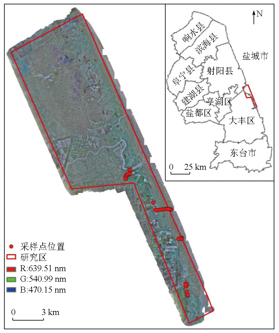
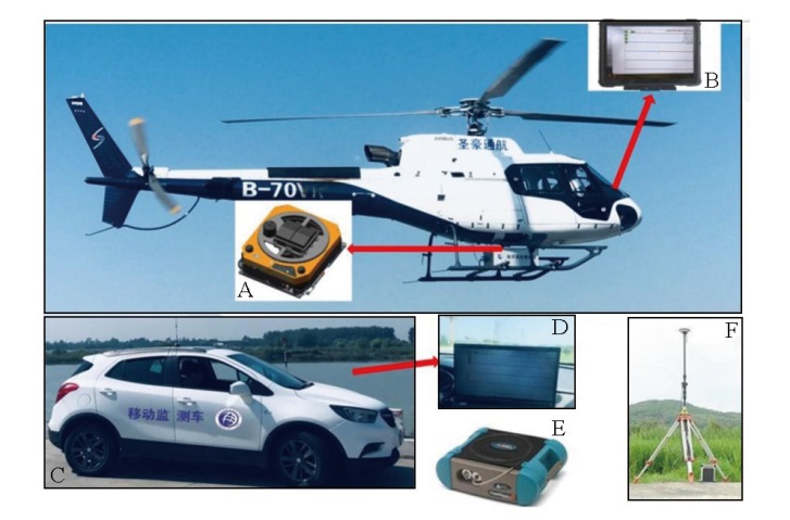
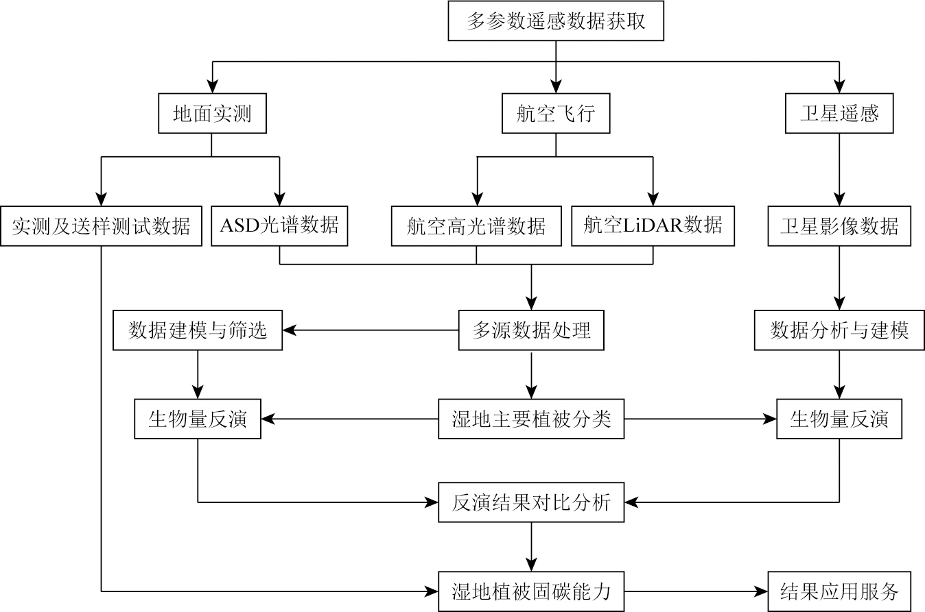
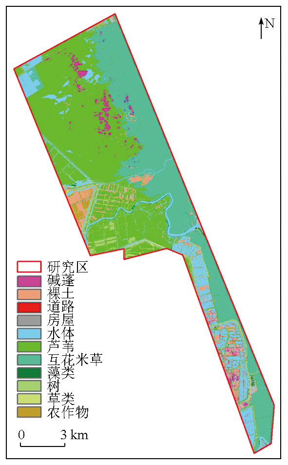
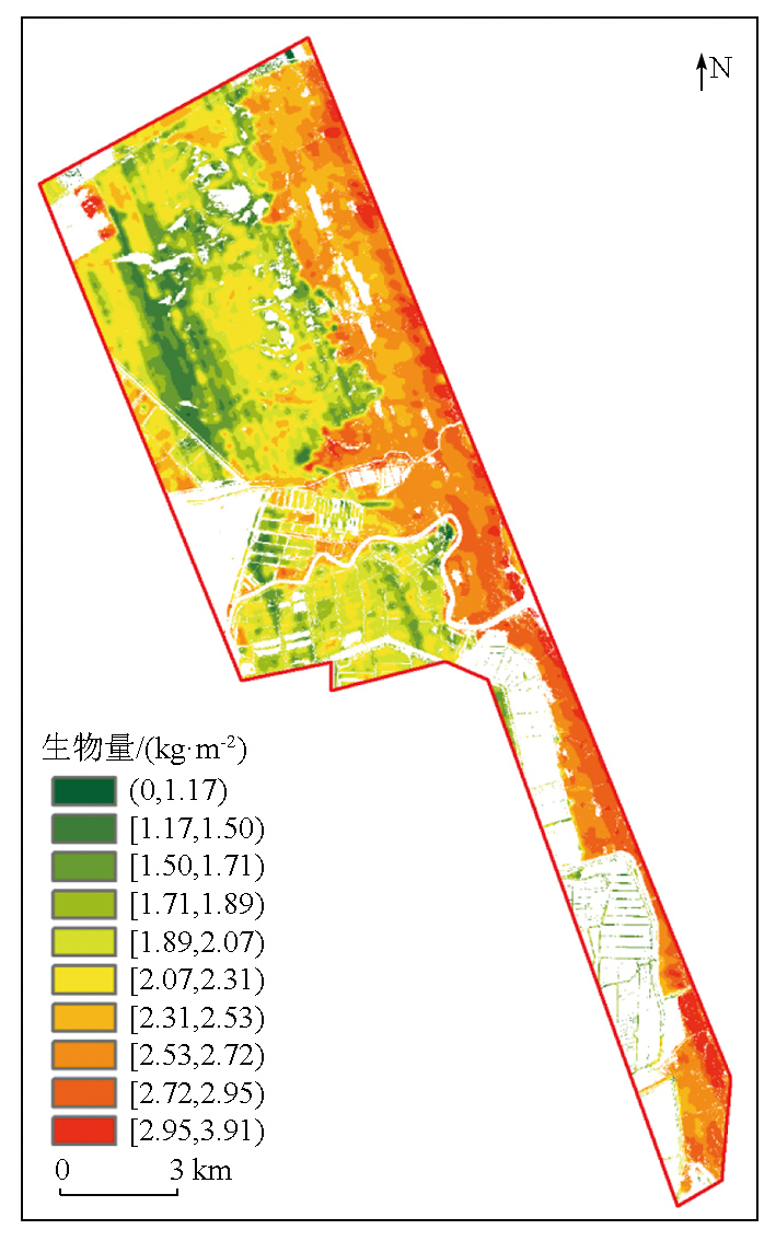
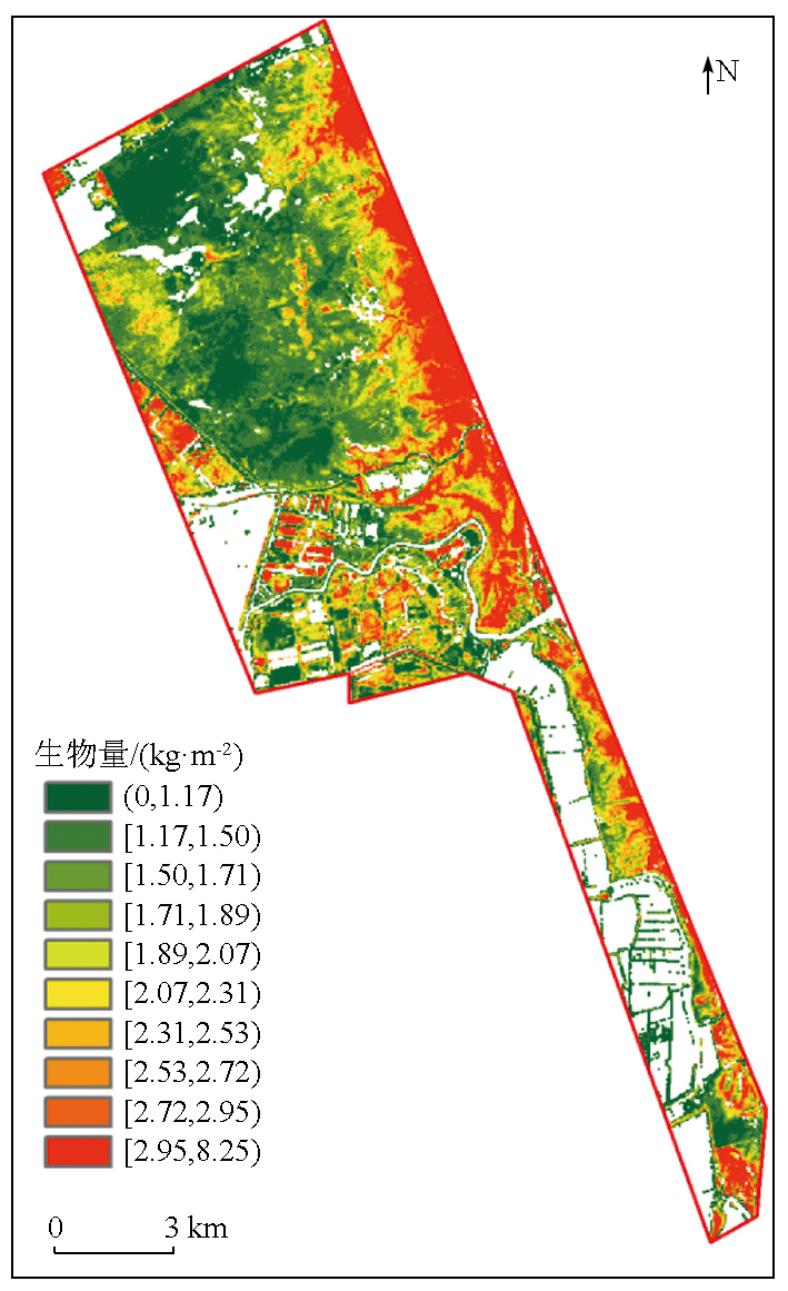
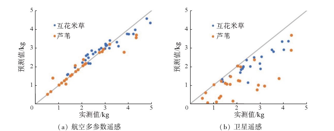
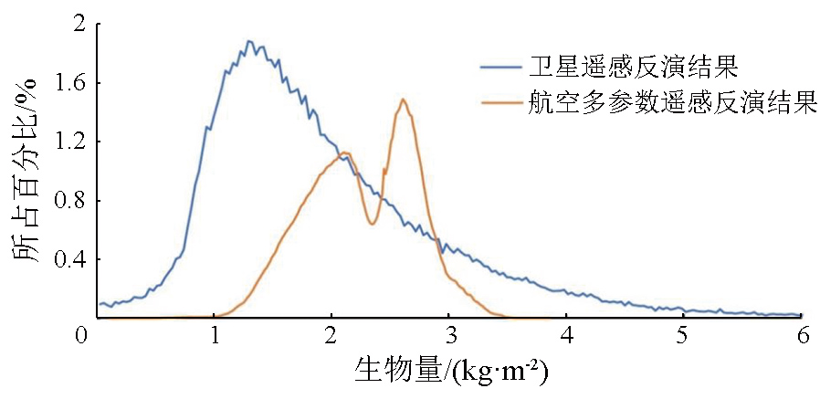
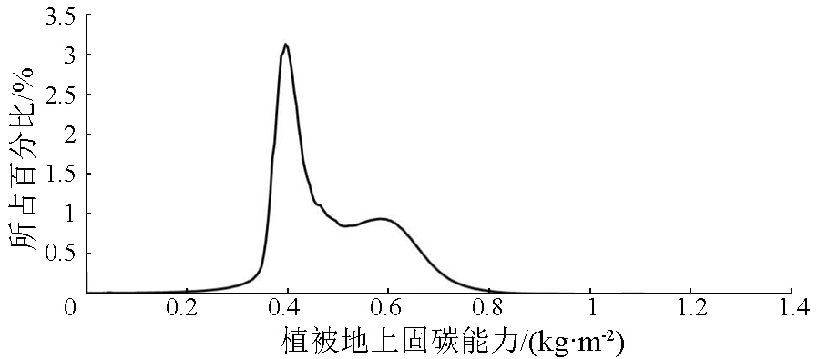
This study investigated the coastal wetland of Jiangsu Province. Using methods such as satellite remote sensing and airborne multi-parameter remote sensing, this study estimated the biomass of dominant plants and estimated their carbon sequestration capacities. Based on fine-scale classification of surface features achieved using airborne hyperspectral data, this study extracted 11 land cover types. The vegetation cover was approximately 76%, and zones with human activities accounted for about 1.5% of the study area. The model for vegetation biomass inversion using the multi-parameter airborne remote sensing demonstrated higher accuracy than that based on satellite remote sensing, with a coefficient of determination (R2) greater than 0.8 and a root mean square error (RMSE) of 0.25. As calculated using the multi-parameter airborne remote sensing, Spartina alterniflora and reed within the study area exhibited aboveground carbon sequestration capacities of 0.41 kg/m2 and 0.58 kg/m2, respectively. This study demonstrates that the multi-parameter airborne remote sensing method can accurately determine vegetation types in wetlands and carbon sequestration capacity, thus providing crucial assessment parameters for research on the carbon cycle of the ecosystem and the current status of habitats within wetlands and precisely serving wetland resource surveys.
Cao L, Song J M, Li X G, et al. Research progresses in carbon budget and carbon cycle of the coastal salt marshes in China[J]. Acta Ecologica Sinica, 2013, 33(17):5141-5152.
Yang Q M, Yuan D P, Deng C B, et al. Research progress on net carbon sequestration capacity of plants under the background of carbon neutralization[J]. Chinese Journal of Ecology, 2023, 42(6):1484-1496.
Ye S Y, Zhao G M, Pei S F, et al. Evaluation technology and method of carbon sequestration capacity of coastal wetlands[M]. Wuhan: China University of Geosciences Press, 2016:42-48.
Cui L J, Ma Q F, Song H T, et al. Estimation methods of wetland ecosystem carbon storage:A review[J]. Chinese Journal of Ecology, 2012, 31(10):2673-2680.
Zhao T G, Yu R H, Zhang Z L, et al. Estimation of wetland vegetation aboveground biomass based on remote sensing data:A review[J]. Chinese Journal of Ecology, 2016, 35(7):1936-1946.
[6]
Aslan A, Rahman A F, Warren M W, et al. Mapping spatial distribution and biomass of coastal wetland vegetation in Indonesian Papua by combining active and passive remotely sensed data[J]. Remote Sensing of Environment, 2016, 183:65-81.
Chai Y, Ruan R Z, Chai G W, et al. Species identification of wetland vegetation based on spectral characteristics[J]. Remote Sens-ing for Land and Resources, 2016, 28(3):86-90.doi: 10.6046/gtzyyg.2016.03.14.
[8]
Pride M, Priscilla M T, Gara T. Dominant wetland vegetation species discrimination and quantification using in situ hyperspectral data[J]. Transactions of the Royal Society of South Africa, 2020, 75(3):229-238.
[9]
Ecarnot M, Compan F, Roumet P. Assessing leaf nitrogen content and leaf mass per unit area of wheat in the field throughout plant cycle with a portable spectrometer[J]. Field Crops Research, 2013, 140:44-50.
[10]
Estornell J, Ruiz L A, Velázquez-Martí B, et al. Estimation of shrub biomass by airborne LiDAR data in small forest stands[J]. Forest Ecology and Management, 2011, 262(9):1697-1703.
[11]
Swatantran A, Dubayah R, Roberts D, et al. Mapping biomass and stress in the Sierra Nevada using LiDAR and hyperspectral data fusion[J]. Remote Sensing of Environment, 2011, 115(11):2917-2930.
Yu H Y. Research on estimation of coastal wetland vegetation above-ground biomass with airborne hyperspectral and LiDAR data[D]. Beijing: Chinese Academy of Surveying and Mapping, 2015.
[13]
Luo S Z, Wang C, Xi X H, et al. Retrieving aboveground biomass of wetland Phragmites australis (common reed) using a combination of airborne discrete-return LiDAR and hyperspectral data[J]. International Journal of Applied Earth Observation and Geoinformation, 2017, 58:107-117.
Yang S R, Xue Z H, Zhang L, et al. Fusion of hyperspectral and LiDAR data:A case study for refined crop classification in agricul-tural region of Zhangye Oasis in the middle reaches of Heihe River[J]. Remote Sensing for Land and Resources, 2018, 30(4):33-40.doi:10.6046/gtzyyg.2018.04.06.
[15]
Pang Y, Li Z Y. Subtropical forest biomass estimation using airborne LiDAR and hyperspectral data[J]. The International Archives of the Photogrammety,Remote Sensing and Spatial Information Sciences, 2016, XLI-B8:747-749.
[16]
Latifi H, Fassnacht F, Koch B. Forest structure modeling with combined airborne hyperspectral and LiDAR data[J]. Remote Sensing of Environment, 2012, 121:10-25.
[17]
Wang J, Liu Z, Yu H, et al. Mapping Spartina alterniflora biomass using LiDAR and hyperspectral data[J]. Remote Sensing, 2017, 9(6):589.
[18]
Jensen D, Cavanaugh K C, Simard M, et al. Integrating imaging spectrometer and synthetic aperture radar data for estimating wetland vegetation aboveground biomass in coastal Louisiana[J]. Remote Sensing, 2019, 11(21):2533.
Zhao Y H, Hou P, Jiang J B, et al. Progress in quantitative inversion of vegetation ecological remote sensing parameters[J]. National Remote Sensing Bulletin, 2021, 25(11):2173-2197.
[20]
He L, Li A, Yin G, et al. Retrieval of grassland aboveground biomass through inversion of the PROSAIL model with MODIS imagery[J]. Remote Sensing, 2019, 11(13):1597.
Sun F J, Ju W M, Fang M H, et al. Retrieval of forest above ground biomass using 4-scale geometrical optical model and remote sens-ing data[J]. Remote Sensing Technology and Application, 2018, 33(6):1046-1055.
[22]
Wan R R, Wang P, Wang X L, et al. Mapping aboveground biomass of four typical vegetation types in the Poyang Lake wetlands based on random forest modelling and landsat images[J]. Frontiers in Plant Science, 2019, 10:1281.
Gou F Z, Zhao C Z, Yang J C, et al. Spatial heterogeneity of above-ground biomass in Sugan Lake wetland vegetation[J]. Acta Ecolo-gica Sinica, 2021, 41(19):7774-7784.
[24]
Yang S X, Feng Q S, Liang T G, et al. Modeling grassland above-ground biomass based on artificial neural network and remote sens-ing in the Three-River Headwaters Region[J]. Remote Sensing of Environment, 2018, 204:448-455.
Zou Y, Li H, Zhang J B, et al. Inversion of aboveground biomass of saltmarshes in coastal wetland using remote sensing[J]. Acta Ecologica Sinica, 2023, 43(20):8532-8543.
Sun S Z, Wang C J, Yin X J, et al. Estimating aboveground biomass of natural grassland based on multispectral images of unmanned aerial vehicles[J]. Journal of Remote Sensing, 2018, 22(5):848-856.
Kang X Y, Zhang A W, Pang H Y. Estimation of grassland aboveground biomass from UAV-mounted hyperspectral image by optimized spectral reconstruction[J]. Spectroscopy and Spectral Analysis, 2021, 41(1):250-256.
Zhang H B, Liu H Y, Hao J F, et al. Spatiotemporal characteristics of landscape change in the coastal wetlands of Yancheng caused by natural processes and human activities[J]. Acta Ecologica Sinica, 2012, 32(1):101-110.
Xiu L C, Zheng Z Z, Yang B, et al. Application of airborne hyperspectral imaging technology to the ecological environment protection of Jiangsu,Anhui and Zhejiang Provinces at Yangtze River Economic Belt[J]. Geology in China, 2021, 48(5):1334-1356.
Xu M Z, Liang S, Shi J L, et al. Airborne hyperspectral inversion of heavy metal distribution in cultivated soil:A case study of the Guanhe Area,North Jiangsu Province[J]. East China Geology, 2021, 42(1):100-107.
 2025, Vol. 37
  ), 方彦奇1,2, 陈浩峰1,2, 严维兵1, 黄岩1,2,3(