Stacking-assisted DS-InSAR method for monitoring surface deformations in complex mining areas
LI Zhi1(), ZHANG Shubi1(), LI Minggeng2, CHEN Qiang3, BIAN Hefang1, LI Shijin1, GAO Yandong1, ZHANG Yansuo1, ZHANG Di1
1. School of Environment and Spatial Informatics, China University of Mining and Technology, Xuzhou 221116, China 2. China Railway Shanghai Design Institute Group Corporation Limited, Shanghai 200040, China 3. Yankuang energy Group Company Limited Jining No.3 coal mine, Jining 272000, China
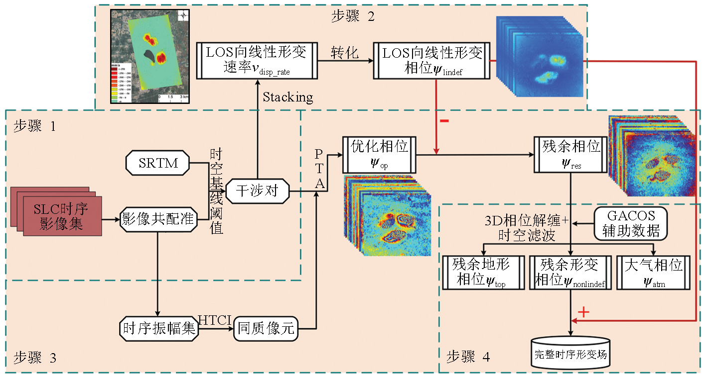
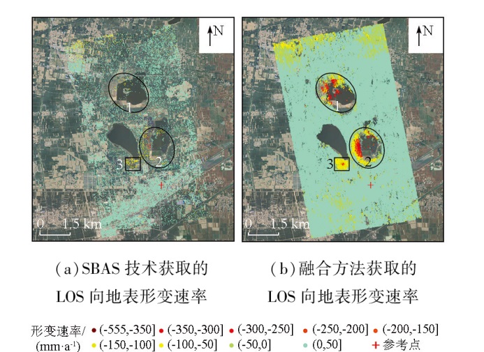
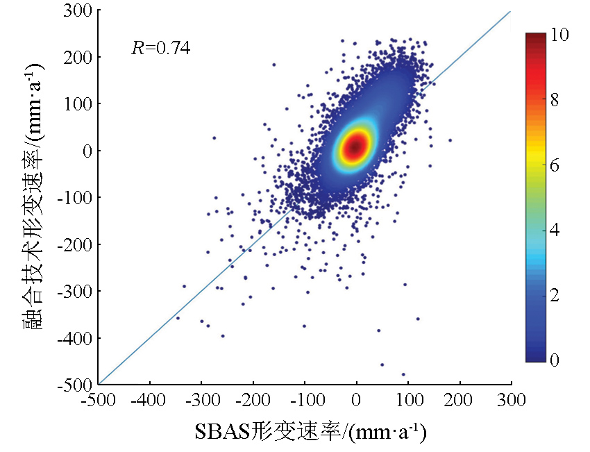
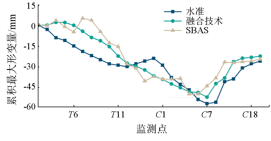
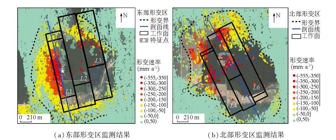
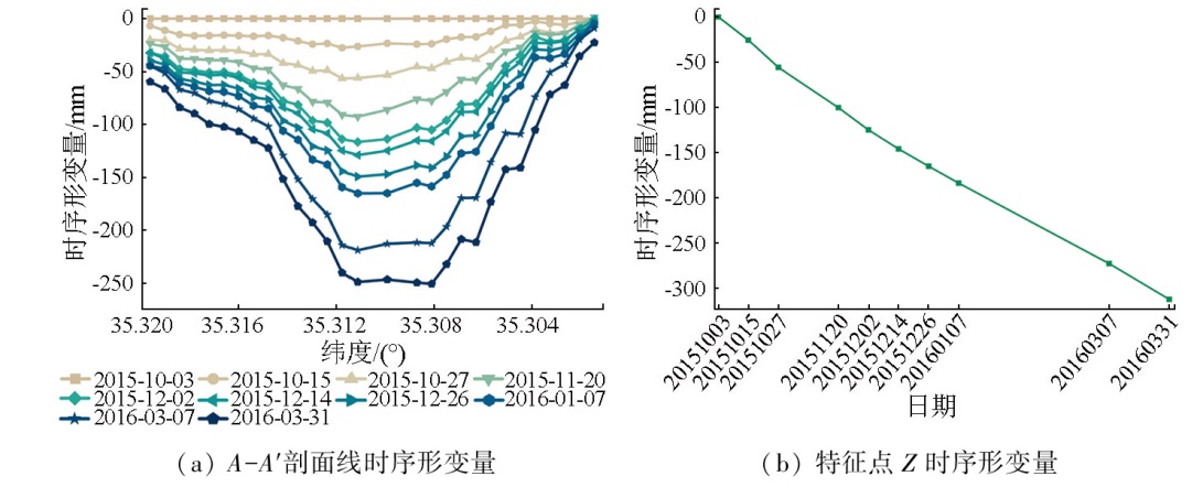
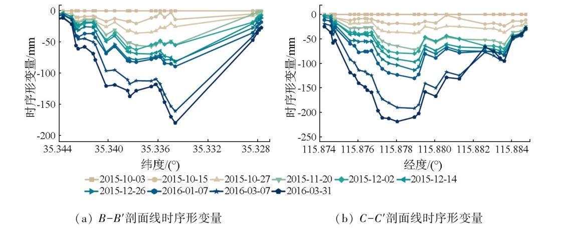
Interferometric Synthetic Aperture Radar (InSAR) faces the challenges of the insufficient number of monitoring points and low monitoring accuracy when applied to complex environments with dense vegetation and large-gradient surface deformation in a mining area. To address these challenges, this study proposed an improved distributed scatterer InSAR (DS-InSAR) method assisted by stacking technology. This method identified statistically homogenous pixels using a confidence interval hypothesis test and achieved phase optimization utilizing a phase triangulation algorithm. Subsequently, the residual phases were derived by removing the linear deformation phases determined via stacking-based simulation. This step contributed to sparse deformation phase fringes, thereby enhancing the accuracy of spatiotemporal filtering and three-dimensional phase unwrapping within the subsequent DS-InSAR processing framework. Finally, the simulated phases were compensated, and thus complete deformation fields were determined. By processing Sentinel-1A SAR images covering the Xinjulong Coal Mine from October 2015 to March 2016, this study interpreted the time-series surface deformation characteristics in the mining area during this period. The findings revealed three significant deformation sites in the mining area, with a maximum cumulative radar line-of-sight (LOS) deformation of up to -313 mm. Compared to conventional small Baseline Subset (SBAS) InSAR, the proposed method yielded more uniformly distributed monitoring points via inversion, with a density approximately 12.9 times higher. The root mean squared error (RMSE) of the inversion was approximately 6.82 mm relative to leveling data, representing an accuracy improvement of about 3.0 mm compared to the SBAS results.
Wang G F, Ren S H, Pang Y H, et al. Development achievements of China’s coal industry during the 13th Five-Year Plan period and implementation path of “dual carbon” target[J]. Coal Science and Technology, 2021, 49(9):1-8.
Xie H P, Wu L X, Zheng D Z. Prediction on the energy consumption and coal demand of China in 2025[J]. Journal of China Coal Society, 2019, 44(7):1949-1960.
[3]
Zhang G, Xu Z X, Chen Z W, et al. Predictable condition analysis and prediction method of SBAS-InSAR coal mining subsidence[J]. IEEE Transactions on Geoscience and Remote Sensing, 2022, 60:1-14.
Zhu J J, Yang Z F, Li Z W. Recent progress in retrieving and predicting mining-induced 3D displace-ments using InSAR[J]. Acta Geodaetica et Cartographica Sinica, 2019, 48(2):135-144.
doi: 10.11947/j.AGCS.2019.20180188
Yu B, Wang B, Liu G X, et al. Deformation monitoring and analysis of mining areas based on the DT-SDFPT combined time-series InSAR[J]. Remote Sensing for Natural Resources, 2024, 36(1):14-25.doi: 10.6046/zrzyyg.2022378.
Li T, Tang X M, Li S J, et al. Classification of basic deformation products of L-band differential interfero-metric SAR satellite[J]. Acta Geodaetica et Cartographica Sinica, 2023, 52(5):769-779.
doi: 10.11947/j.AGCS.2023.20220050
[7]
Gabriel A K, Goldstein R M, Zebker H A. Mapping small elevation changes over large areas:Differential radar interferometry[J]. Journal of Geophysical Research:Solid Earth, 1989, 94(B7):9183-9191.
[8]
Sandwell D T, Price E J. Phase gradient approach to stacking interferograms[J]. Journal of Geophysical Research:Solid Earth, 1998, 103(B12):30183-30204.
[9]
Xu Y Z, Li T, Tang X M, et al. Research on the applicability of DInSAR,stacking-InSAR and SBAS-InSAR for mining region subsidence detection in the Datong coalfield[J]. Remote Sensing, 2022, 14(14):3314.
Wu Q, Ge D Q, Yu J C, et al. Deep learning identification technology of InSAR significant deformation zone of potential landslide hazard at large scale[J]. Acta Geodaetica et Cartographica Sinica, 2022, 51(10):2046-2055.
doi: 10.11947/j.AGCS.2022.20220303
[11]
Ferretti A, Prati C, Rocca F. Permanent scatterers in SAR interferometry[J]. IEEE Transactions on Geoscience and Remote Sensing, 2001, 39(1):8-20.
[12]
Berardino P, Fornaro G, Lanari R, et al. A new algorithm for surface deformation monitoring based on small baseline differential SAR interferograms[J]. IEEE Transactions on Geoscience and Remote Sensing, 2002, 40(11):2375-2383.
[13]
Ferretti A, Fumagalli A, Novali F, et al. A new algorithm for processing interferometric data-stacks:SqueeSAR[J]. IEEE Transactions on Geoscience and Remote Sensing, 2011, 49(9):3460-3470.
[14]
Zhao C J, Li Z, Tian B S, et al. A ground surface deformation monitoring InSAR method using improved distributed scatterers phase estimation[J]. IEEE Journal of Selected Topics in Applied Earth Observations and Remote Sensing, 2019, 12(11):4543-4553.
Jiang M, Ding X L, He X F, et al. FaSHPS-InSAR technique for distributed scatterers:A case study over the lost hills oil field,California[J]. Chinese Journal of Geophysics, 2016, 59(10):3592-3603.
Jiang M, Ding X L, Li Z W. Homogeneous pixel selection algorithm for multitemporal InSAR[J]. Chinese Journal of Geophysics, 2018, 61(12):4767-4776.
[17]
Wang H N, Li K L, Zhang J, et al. Monitoring and analysis of ground surface settlement in mining clusters by SBAS-InSAR technology[J]. Sensors, 2022, 22(10):3711.
[18]
Ma J Q, Yang J C, Zhu Z R, et al. Decision-making fusion of InSAR technology and offset tracking to study the deformation of large gradients in mining areas-Xuemiaotan mine as an example[J]. Frontiers in Earth Science, 2022, 10:962362.
Gao Y D, Jia Y K, Li S J, et al. The improved max-flow/Min-cut weight algorithm for InSAR phase unwrapping[J]. Acta Geodaetica et Cartographica Sinica, 2024, 53(4):644-652.
doi: 10.11947/j.AGCS.2024.20220633
[20]
Feng X M, Chen Z Q, Li G, et al. Improving the capability of D-InSAR combined with offset-tracking for monitoring glacier velocity[J]. Remote Sensing of Environment, 2023, 285:113394.
 2025, Vol. 37
  ), 张书毕1(