Exploring the spatial distribution of surface deformations along the China-Laos railway based on SBAS-InSAR technology: Taking the Jinghong section as an example
JIN Tingting1(), XI Wenfei1,2(), QIAN Tanghui1, GUO Junqi1, HONG Wenyu1, DING Zitian1, GUI Fuyu1
1. Department of Geography, Yunnan Normal University,Kunming 650500,China 2. The Key Laboratory of Plateau Geographic Process and Environmental Change in Yunnan Province,Kunming 650500,China
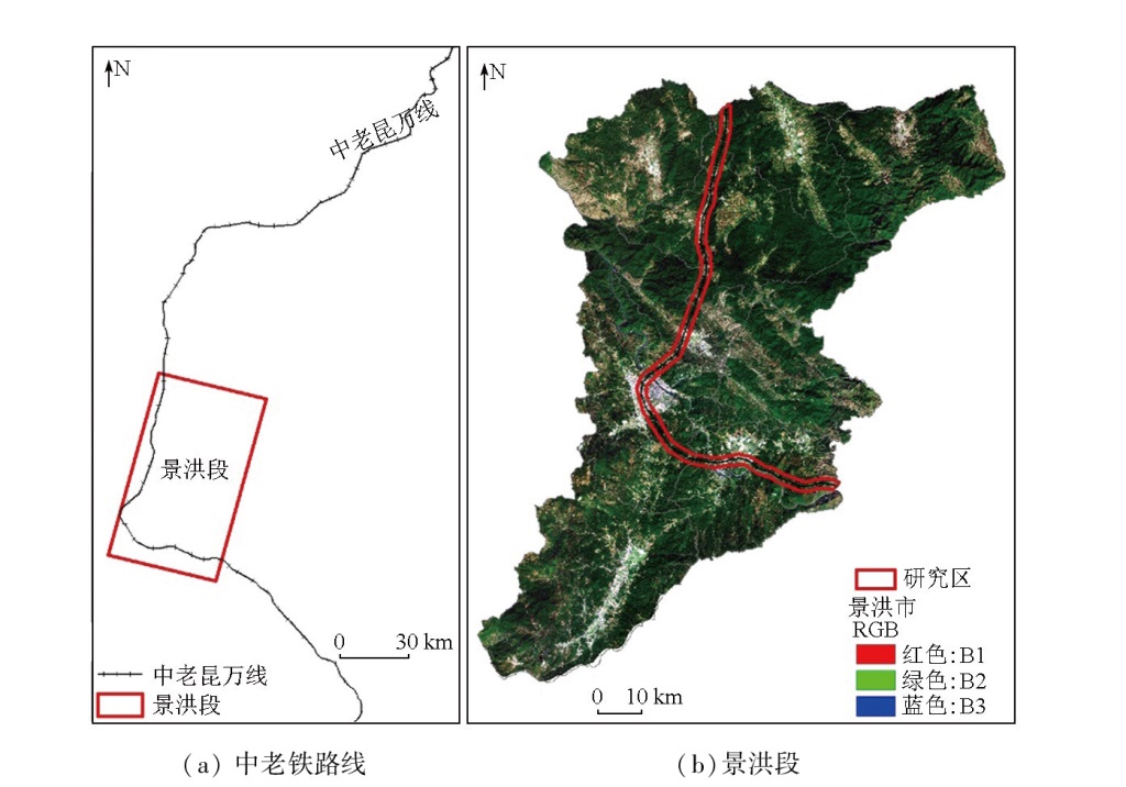
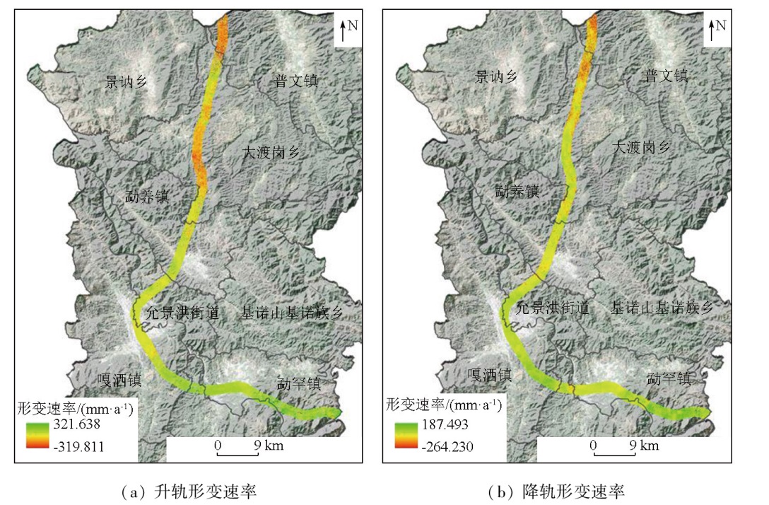
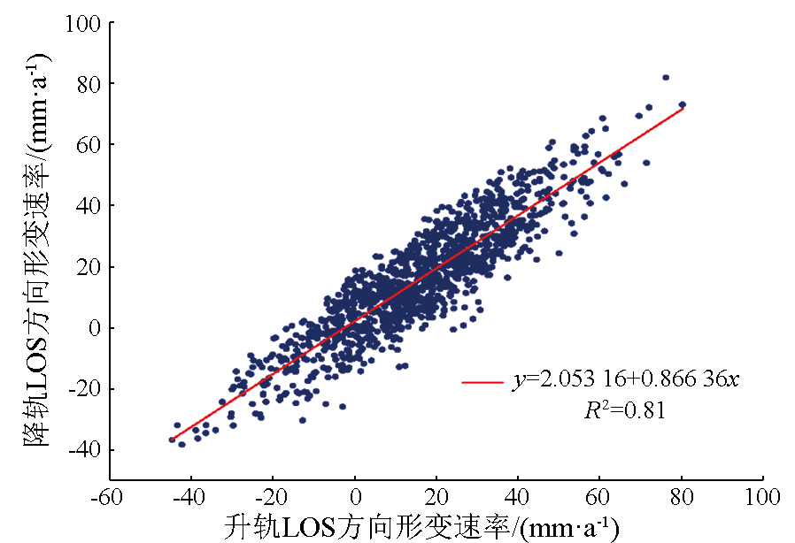
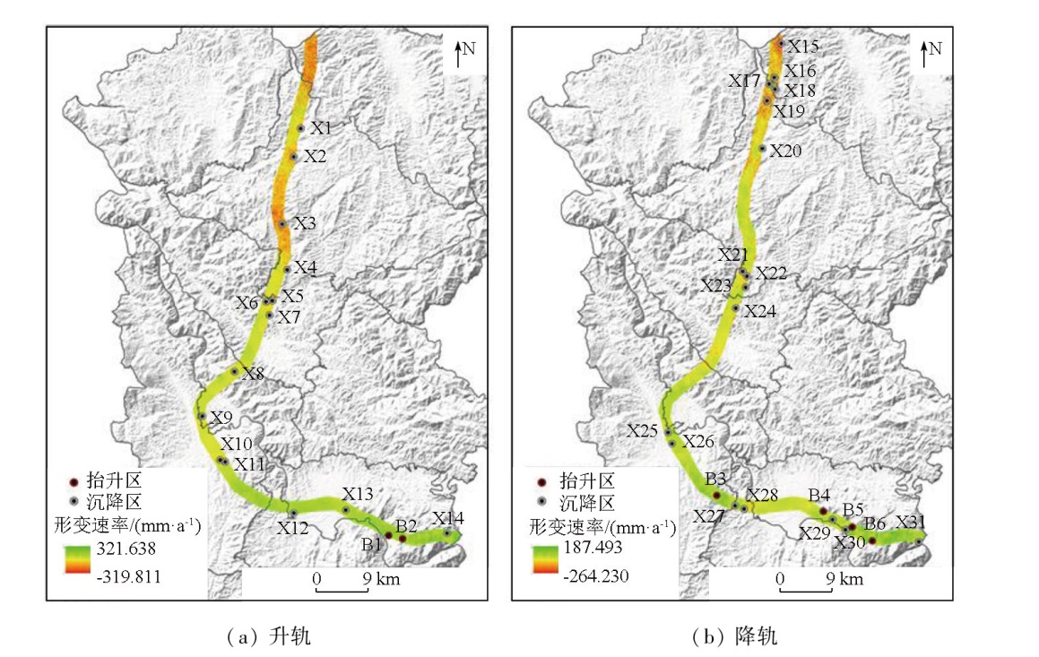
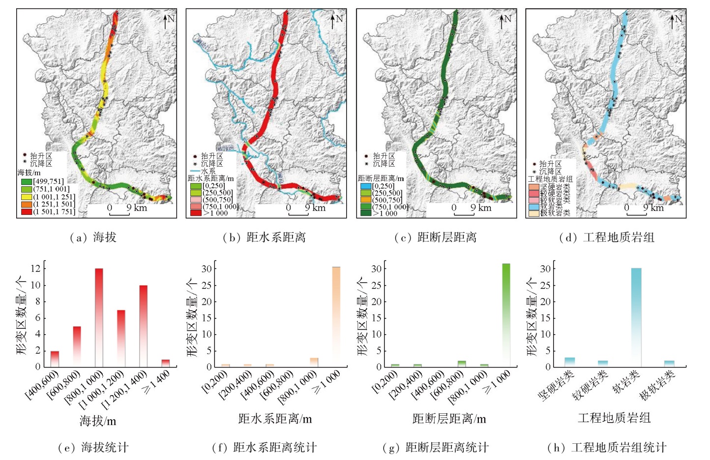
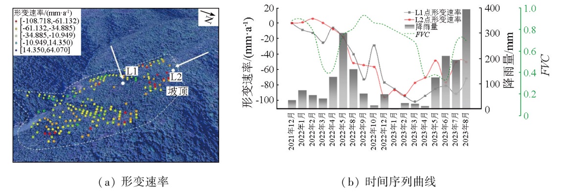
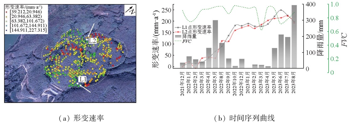
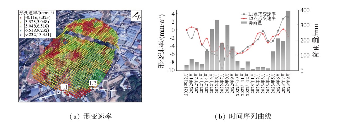
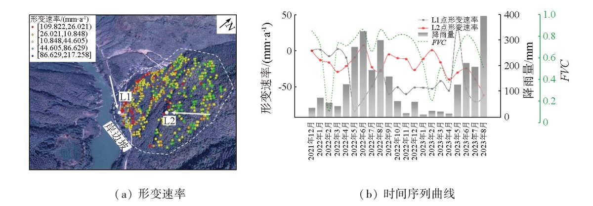
Surface deformations pose significant threats to the normal operation of railways. Investigating the spatial distribution of surface deformations along the China-Laos railway holds great significance for disaster prevention and mitigation. Based on 36 scenes of ascending orbit and 50 scenes of descending orbit images from Sentinel-1A satellite from December 2021 to August 2023, this study conducted deformation inversion using the small baseline subset interferometric synthetic aperture Radar (SBAS-InSAR) technique. Besides, this study conducted spatial distribution statistics and analysis of surface deformations along the Jinghong section of the China-Laos railway. The results indicate that the overall deformation along the railway exhibits a heterogeneous distribution, with multiple potential hazards in the northern mountainous area. Among the selected typical deformation zones, the maximum subsidence rate in the northern mountainous area reaches -108.718 mm/a, whereas the southern plain area shows significant uplift with a rate of 227.315 mm/a. Along the railway, the surface deformation rates in the line of sight (LOS) direction ranged from -319.811 mm/a to 321.638 mm/a. Obvious subsidence occurred in Puwen Town and Dadugang Township. Conversely, minor subsidence was observed in urban areas like Mengyang town, Yunjinghong subdistrict, and Gasa town, with pronounced uplifts in the southeastern part of Menghan town. Along the railway, deformations in mountainous areas were primarily concentrated at elevations ranging from 800 m to 1400 m, with soft rocks prevailing in these deformed areas. InSAR-based analysis of the spatial distribution of the surface deformations along the railway is of significant value for the safe operation of the railway.
靳婷婷, 喜文飞, 钱堂慧, 郭峻杞, 洪文玉, 丁子天, 桂富羽. 基于SBAS-InSAR技术的中老铁路沿线地表形变空间分布研究——以景洪段为例[J]. 自然资源遥感, 2025, 37(4): 232-240.
JIN Tingting, XI Wenfei, QIAN Tanghui, GUO Junqi, HONG Wenyu, DING Zitian, GUI Fuyu. Exploring the spatial distribution of surface deformations along the China-Laos railway based on SBAS-InSAR technology: Taking the Jinghong section as an example. Remote Sensing for Natural Resources, 2025, 37(4): 232-240.
Liu K S, Gong H L, Chen B B. Monitoring and analysis of land subsidence of Beijing Metro Line 6 based on InSAR data[J]. Journal of Geo-Information Science, 2018, 20(1):128-137.
Luo S M, Du K F, Wan W N, et al. Ground subsidence rate inversion of large temporal and spatial scales based on extended PSInSAR method[J]. Geomatics and Information Science of Wuhan University, 2014, 39(9):1128-1134.
Zhao G T, Zhao R F, Liu J F. Deformation source,deformation transmission of post-construction settlement and control methods of track irregularity for high-speed railway subgrade[J]. Journal of the China Railway Society, 2020, 42(12):127-134.
Liu C L, Zhang Y J, Lu C M, et al. Spatial-temporal variation characteristics and causes analysis of ground deformation in Jiulong River Estuary area by time series InSAR[J]. Journal of Applied Oceanography, 2024, 43(1):116-125.
Fan J, Zuo X Q, Li T, et al. Analysis and comparison of PS-InSAR and SBAS-InSAR for ground subsidence monitoring in the main city of Kunming[J]. Engineering of Surveying and Mapping, 2018, 27(6):50-58.
Zhu J T, Lan R T, Li H L, et al. Monitoring and analysis of land subsidence in Xiamen City based on time-series InSAR[J]. Hydrographic Surveying and Charting, 2023, 43(5):56-60,66.
Cao J F, Liu H C. Study on interpretation of the reservoir landslide based on QuickBird remote sensing images[J]. Jilin Water Resources, 2017(12):4-6,10.
Zhu Y F, Yao X, Yao L H, et al. Identification and risk assessment of coal mining-induced landslides in Guizhou Province by InSAR and optical remote sensing[J]. Journal of Geomechanics, 2022, 28(2):268-280.
Wei D N, Wang S J. Settlement monitoring and analysis along Xi’an metro line based on time series InSAR technology[J]. Progress in Geophysics, 2024, 39(2):498-509.
Wang Y, Liao M S, Li D R, et al. Subsidence velocity retrieval from long-term coherent targets in Radar interferometric stacks[J]. Chinese Journal of Geophysics, 2007, 50(2):598-604.
Ge P F, Liu H, Chen M, et al. Monitoring land subsidence of Hebei section of Beijing-Xiongan intercity railway by time-series InSAR[J]. Bulletin of Surveying and Mapping, 2022(7):64-70.
Chen B S, Zhang L F, He Y, et al. Surface deformation monitoring and cause analysis of the section from the army horse ranch to Minle station of the Lanxin high-speed railway[J]. Journal of Lanzhou University (Natural Sciences), 2022, 58(2):222-228,238.
[13]
Heleno S I N, Oliveira L G S, Henriques M J, et al. Persistent Scatterers Interferometry detects and measures ground subsidence in Lisbon[J]. Remote Sensing of Environment, 2011, 115(8):2152-2167.
Zhang X D, Ge D Q, Xiao B, et al. Study on multi-track integration PS-InSAR monitoring the land subsidence along the highway—Taking Jinghu highway(Beijing-Hebei) as an example[J]. Bulletin of Surveying and Mapping, 2014(10):67-69,104.
[15]
He Y, Chen Y, Wang W, et al. TS-InSAR analysis for monitoring ground deformation in Lanzhou New District,the loess Plateau of China,from 2017 to 2019[J]. Advances in Space Research, 2021, 67(4):1267-1283.
[16]
Wang W, He Y, Zhang L, et al. Analysis of surface deformation and driving forces in Lanzhou[J]. Open Geosciences, 2020, 12(1):1127-1145.
Chen Y D, He Y, Zhang L F, et al. Research on ground deformation monitoring technique of jointing ascending and descending Sentinel-1A[J]. Hydrographic Surveying and Charting, 2020, 40(4):59-64.
Wang W H, He Y, Zhang L F, et al. Ground deformation monitoring and driving force analysis of the main city area in Lanzhou based on PS-InSAR and GeoDetector[J]. Journal of Lanzhou University (Natural Sciences), 2021, 57(3):382-388,394.
Zhang S J, Jiang J J, Miao Y M, et al. Application of the SBAS technique in potential landslide identification in the Minjiang watershed[J]. Mountain Research, 2018, 36(1):91-97.
Li L J, Yao X, Zhang Y S, et al. SBAS-InSAR technology based identification of slow deformation of geologic mass along section of China-Pakistan highway[J]. Journal of Engineering Geology, 2014, 22(5):921-927.
[21]
Berardino P, Fornaro G, Lanari R, et al. A new algorithm for surface deformation monitoring based on small baseline differential SAR interferograms[J]. IEEE Transactions on Geoscience and Remote Sensing, 2002, 40(11):2375-2383.
He Q, Wei L, Xiao Y H. Analysis of spatial-temporal distribution characteristics and influencing factors of land subsidence in Bozhou City,Anhui Province based on SBAS-InSAR technology[J]. The Chinese Journal of Geological Hazard and Control, 2023, 34(5):81-90.
[23]
Su X J, Zhang Y, Meng X M, et al. Landslide mapping and analysis along the China-Pakistan Karakoram Highway based on SBAS-InSAR detection in 2017[J]. Journal of Mountain Science, 2021, 18(10):2540-2564.
 2025, Vol. 37
  ), 喜文飞1,2(