Relationship between modified water stress-based NPP inversion and soil moisture in typical plateau basins
YANG Zhen1,2(), YANG Minglong1,2(), LI Guozhu1,3, XIA Yonghua1,2, YU Ting4, YAN Zhengfei1,2, LI Wantao1,2
1. Faculty of Land Resources Engineering,Kunming University of Science and Technology,Kunming 650093,China 2. Surveying and Mapping Geo-informatics Technology Research Center on Plateau Mountains of Yunnan Higher Education,Kunming 650093,China 3. Yunnan Haiju Geographic Information Technology Co.,Ltd.,Kunming 650000,China 4. Yunnan Institute of Water Resources and Hydropower Research,Kunming 650228,China
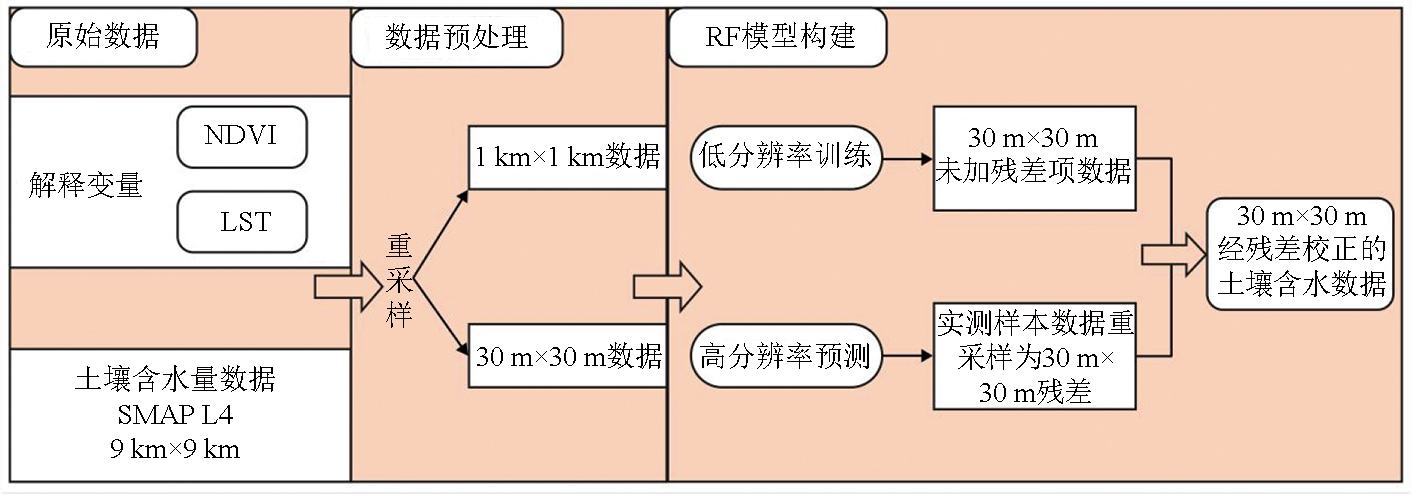
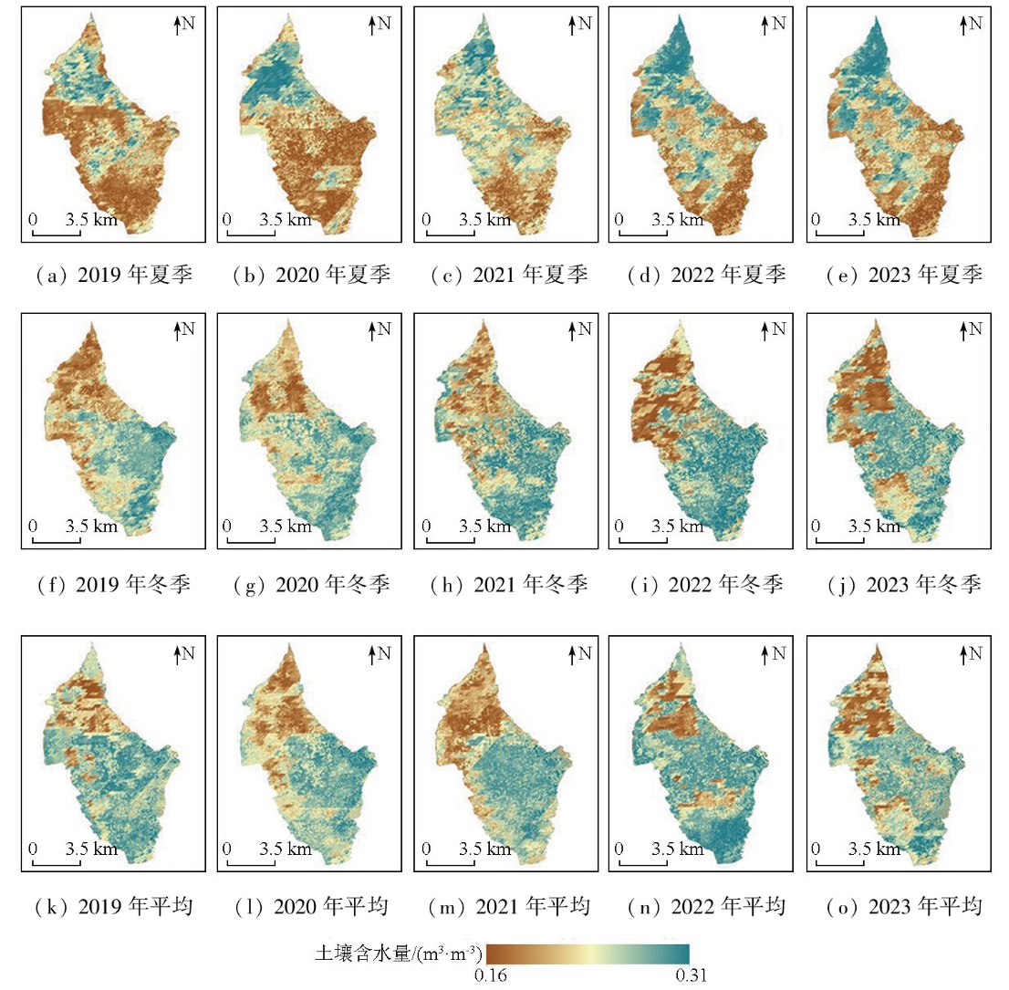
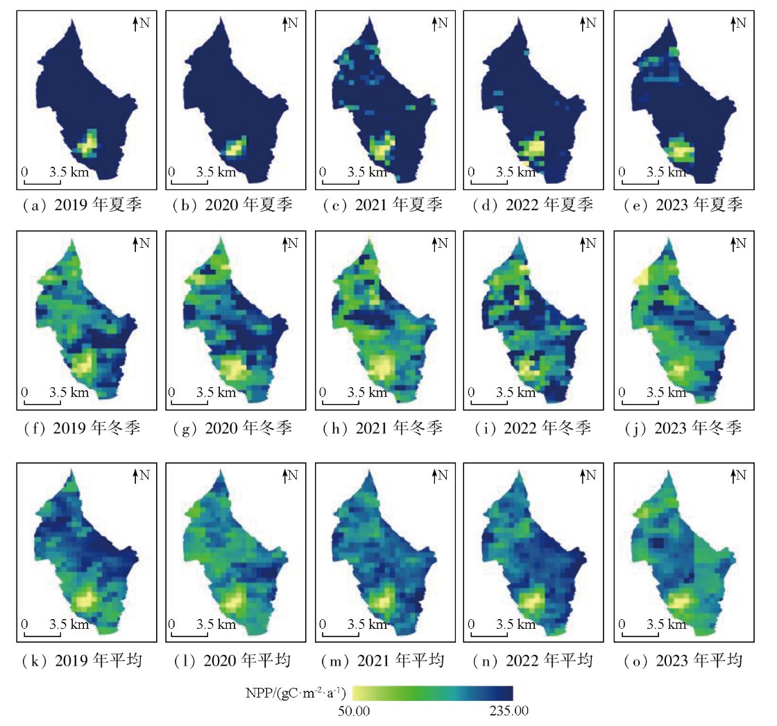
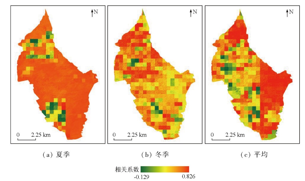
This study aims at investigating variations in soil moisture and vegetation net primary productivity (NPP) in the Qingling River Irrigation Area,Yunnan (elevation 1 515~1 876 m),a typical subtropical alpine climate region. To this end,initially,this study recognized land surface temperature (LST) and normalized difference vegetation index (NDVI) as explanatory variables,leveraging remote sensing technology for rapid and long-term sequential monitoring. Subsequently,the SMAP L4 soil moisture product was downscaled to a 30 m spatial resolution using the random forest adaptive window regression algorithm. Then,the water stress parameter of the CASA model was modified using the land surface water index (LSWI),which integrated multi-source remote sensing data,such as surface reflectance,to estimate NPP. Following spatial resampling,a 30 m resolution NPP spatial distribution was achieved. Finally,multiple land cover scenarios,including forest land,paddy fields,and irrigated farmland,were established. The Pearson correlation coefficient was introduced for the quantitative evaluation of the spatial relationship between soil moisture and NPP in the study area. In terms of the spatial distribution of soil moisture,the study area exhibited higher values in the north and lower values in the south during summer,while lower values in the northwest and higher values in the southeast and south during winter. Compared to field measurements,the inverted NPP results showed a R2>0.7 and a RMSE<0.3. Both summer,winter,and annual average NPP values at the pixel level showed an increasing trend over time. Spatially,scenarios such as paddy fields and forested land presented correlation coefficients exceeding 0.5. Among these,forest land was least sensitive to water stress,while paddy fields and irrigated farmland were most affected. This study establishes a monitoring and feedback mechanism for the soil moisture-NPP balance from seasonal and spatial perspectives in the study area.
杨赈, 杨明龙, 李国柱, 夏永华, 俞婷, 严正飞, 李万涛. 修正水分胁迫的NPP反演结果与典型高原盆地土壤水分关系探究[J]. 自然资源遥感, 2025, 37(5): 267-277.
YANG Zhen, YANG Minglong, LI Guozhu, XIA Yonghua, YU Ting, YAN Zhengfei, LI Wantao. Relationship between modified water stress-based NPP inversion and soil moisture in typical plateau basins. Remote Sensing for Natural Resources, 2025, 37(5): 267-277.
Zhang Y B, Zhang L N, Wang J D. Effects of full-film wide and narrow row planting of corn on soil moisture and yield in central Gansu dry farming area[J]. Water Saving Irrigation, 2023(12):9-17.
[3]
Chen X, Zhang Y P. Impacts of climate,phenology,elevation and their interactions on the net primary productivity of vegetation in Yunnan,China under global warming[J]. Ecological Indicators, 2023, 154:110533.
Yuan J T, Chen W X, Zeng J. Spatio-temporal differentiation of cropland use change and its impact on cropland NPP in China[J]. Journal of Natural Resources, 2023, 38(12):3135-3149.
Tian D Z, Wu S, Xu M S, et al. Observational research on carbon flux of forest ecosystem based on eddy covariance[J]. Modern Information Technology, 2022, 6(11):149-152.
Wu Q T, Li Y J, Shi X P, et al. Primary productivity assessment of typical reservoirs in Guangdong Province based on chlorophyll measurement[J]. Journal of Aquaculture, 2022, 43(10):4-8.
Fang H L, Cheng X F, Qin L. Estimation of net primary productivity of vegetation in Anhui Province based on improved CASA model[J]. Acta Ecologica Sinica, 2024, 44(4):1601-1612.
Xu Y, Zhou Q H, Dou S Q, et al. Spatiotemporal characteristics of vegetation net primary productivity in Yangtze River Basin based on ZGS and Thornthwaite Memorial models[J]. Bulletin of Soil and Water Conservation, 2022, 42(1):225-232.
Jia C, Wang L N, Tang Y K. Sensitivity analysis of ecophysiological parameters for the simulated carbon flux using the Biome-BGC model in a Hippophae rhamnoides plantation in the loess region[J]. Scientia Silvae Sinicae, 2022, 58(11):49-60.
[10]
Yu D Y, Shi P J, Shao H B, et al. Modelling net primary productivi-ty of terrestrial ecosystems in East Asia based on an improved CASA ecosystem model[J]. International Journal of Remote Sensing, 2009, 30(18):4851-4866.
Shang T H, Jia P P, Sun Y, et al. Spectral characteristics of soil moisture in salinized soil and model fitting accuracy in northern Yinchua City,Ningxia Hui Autonomous Region[J]. Bulletin of Soil and Water Conservation, 2020, 40(4):183-189.
Zhang Z X, Cui J, Gou W T, et al. Drought monitoring and spatiotemporal changes analysis in North China Plain based on temperature vegetation dryness index[J]. Journal of Agricultural Big Data, 2023, 5(1):95-107.
doi: 10.19788/j.issn.2096-6369.230118
[13]
王锡刚. 基于水云模型标定的土壤水分反演研究[D]. 长春: 吉林大学, 2023.
Wang X G. Research on soil moisture retrieval based on the calibration of water cloud model[D]. Changchun: Jilin University, 2023.
Zhao W, Wen F P, Cai J F. Methods,progresses,and challenges of passive microwave soil moisture spatial downscaling[J]. National Remote Sensing Bulletin, 2022, 26(9):1699-1722.
Zhang G P, Wang H L, Zhang X C, et al. Effects of different governance modes on soil moisture and vegetation net primary productivity during the ecological restoration of desertified grassland in Maqu County[J]. Gansu Agricultural Science and Technology, 2022, 53(4):58-63.
Fu S L, Lei J Q, Zhou Y Q, et al. Analysis of land degradation trends and driving factors in Ethiopia based on NPP-WUE[J]. Journal of Desert Research, 2023, 43(1):128-141.
Yue D X, Mu X L, Zhou Y Y, et al. Coupling relationship between net primary productivity and soil moisture content in the Shule River Basin[J]. Journal of Lanzhou University (Natural Sciences), 2021, 57(4):518-527,536.
Wen F P. Spatial downscaling of SMAP passive microwave soil moisture products based on range consistency[D]. Chengdu: Institute of Mountain Hazards and Environment,Chinese Academy of Sciences, 2020.
[19]
Jiang Y Z, Yang K, Shao C K, et al. A downscaling approach for constructing high-resolution precipitation dataset over the Tibetan Plateau from ERA5 reanalysis[J]. Atmospheric Research, 2021, 256:105574.
Liang W H, Liu J K, Chen Q, et al. A comparison of object-oriented methods of extracting Eucalyptus information based on GF-2 images[J]. Forest Resources Management, 2017(6):54-59.
[21]
Guan D J, Nie J L, Zhou L L, et al. How to simulate carbon sequestration potential of forest vegetation? A forest carbon sequestration model across a typical mountain city in China[J]. Remote Sensing, 2023, 15(21):5096.
[22]
Bao G, Bao Y H, Qin Z H, et al. Modeling net primary productivity of terrestrial ecosystems in the semi-arid climate of the Mongolian Plateau using LSWI-based CASA ecosystem model[J]. International Journal of Applied Earth Observation and Geoinformation, 2016, 46:84-93.
[23]
Zhang X L, Xiao W H, Wang Y C, et al. Spatial-temporal changes in NPP and its relationship with climate factors based on sensitivity analysis in the Shiyang River Basin[J]. Journal of Earth System Science, 2019, 129(1):24.
[24]
Wu C Y, Chen K L, et al. Improved CASA model based on satellite remote sensing data:Simulating net primary productivity of Qinghai Lake Basin alpine grassland[J]. Geoscientific Model Development, 2022, 15(17):6919-6933.
[25]
Abdi A M, Vrieling A, Yengoh G T, et al. The El Niño-La Niña cycle and recent trends in supply and demand of net primary productivity in African drylands[J]. Climatic Change, 2016, 138(1):111-125.
[26]
Hou G Y, Wu S X, Long W Y, et al. Quantitative analysis of the impact of climate change and oasification on changes in net primary productivity variation in mid-Tianshan Mountains from 2001 to 2020[J]. Ecological Indicators, 2023, 154:110820.
[27]
Ding H, Yuan Z, Shi X L, et al. Soil moisture content-based analysis of terrestrial ecosystems in China:Water use efficiency of vegetation systems[J]. Ecological Indicators, 2023, 150:110271.
[28]
Yin C H, Luo M, Meng F H, et al. Contributions of climatic and anthropogenic drivers to net primary productivity of vegetation in the Mongolian Plateau[J]. Remote Sensing, 2022, 14(14):3383.
 2025, Vol. 37
  ), 杨明龙1,2(