Altered mineral mapping and characteristic analysis in Qianhongquan Area,Beishan,Gansu Province,based on hyperspectral data from the ZY-1 02D satellite
HE Haiyang1,2(), LI Shijie1(), QIN Haoyang1, LIU Xiaoyu1, WANG Siqi1, SUN Xu1
1. Xi’an Mineral Resources Research Center of China Geological Survey,Xi’an 710100,China 2. Technology Innovation Center for Gold Ore Exploration,China Geological Survey,Xi’an 710100,China
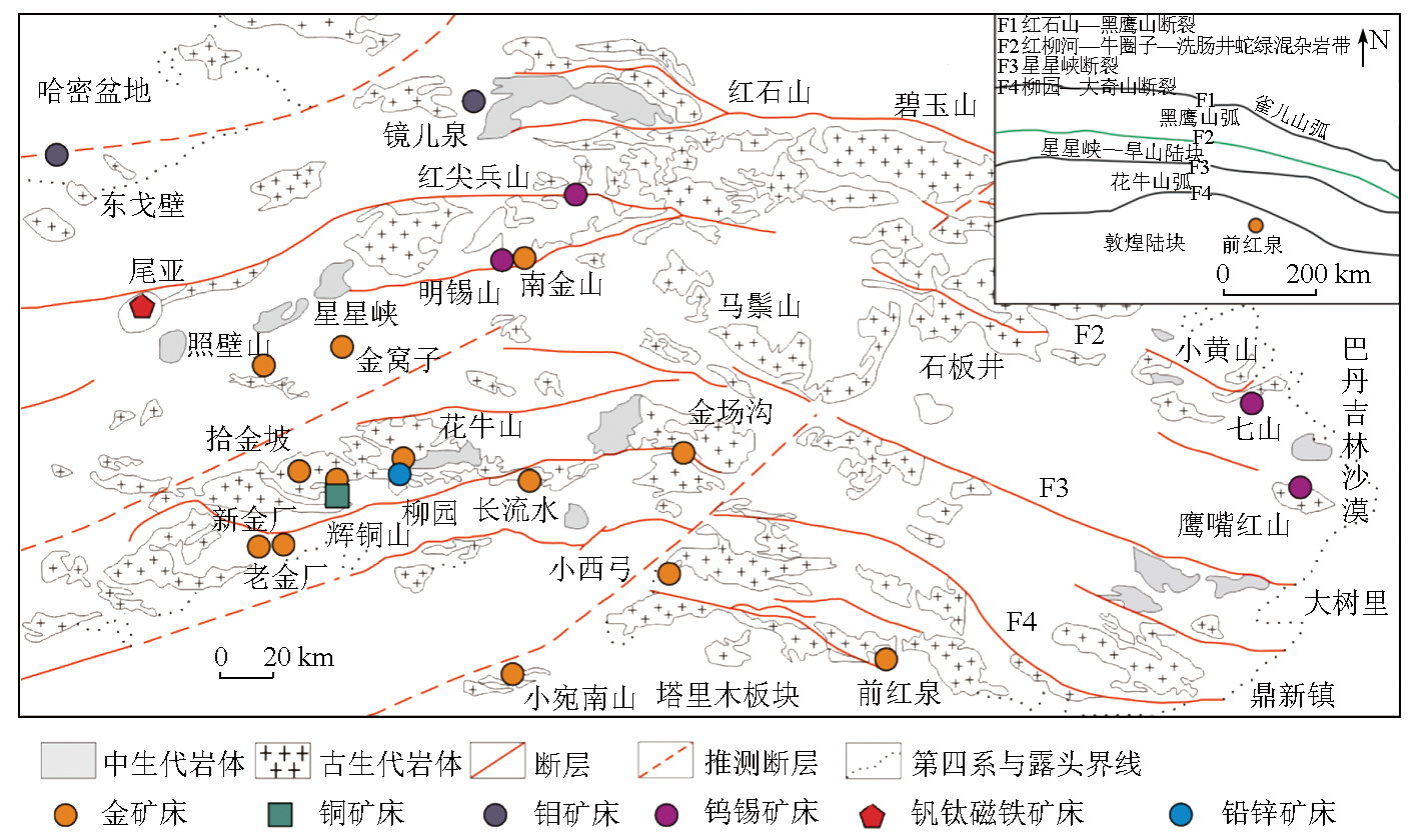
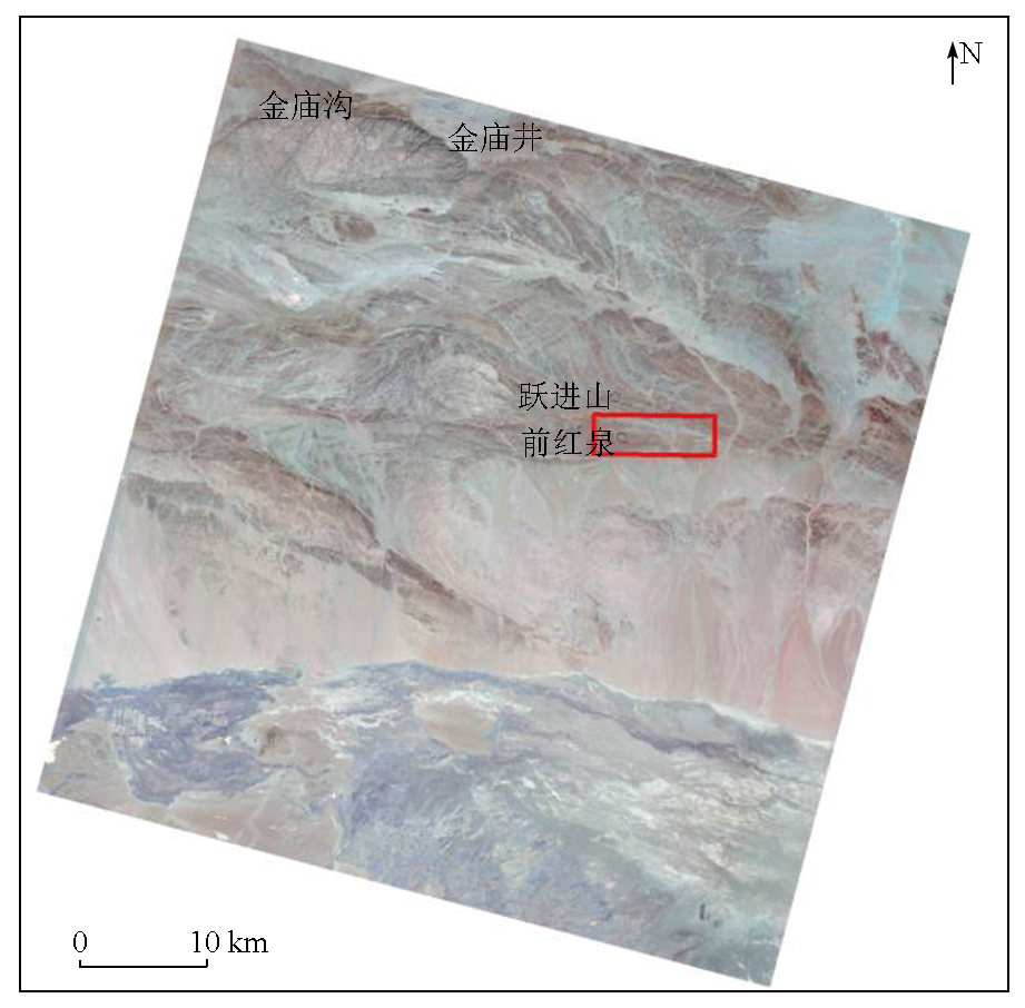
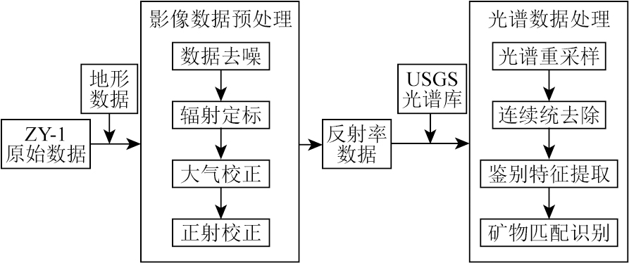
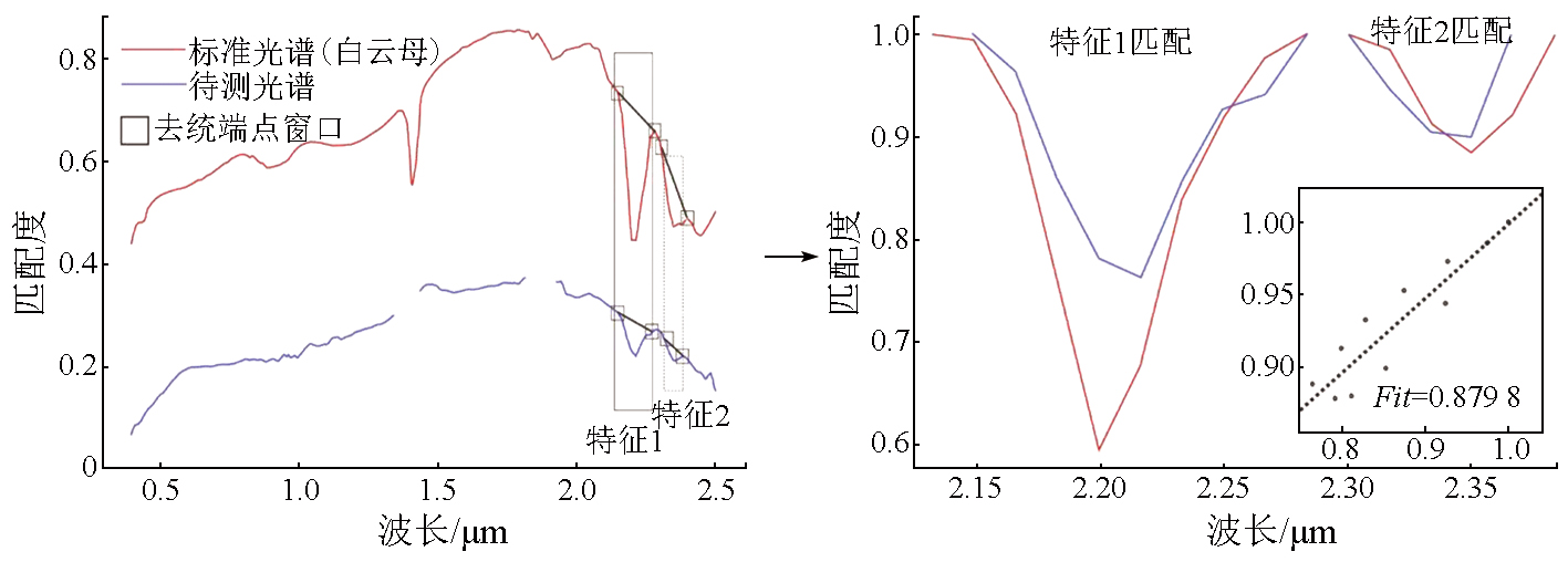
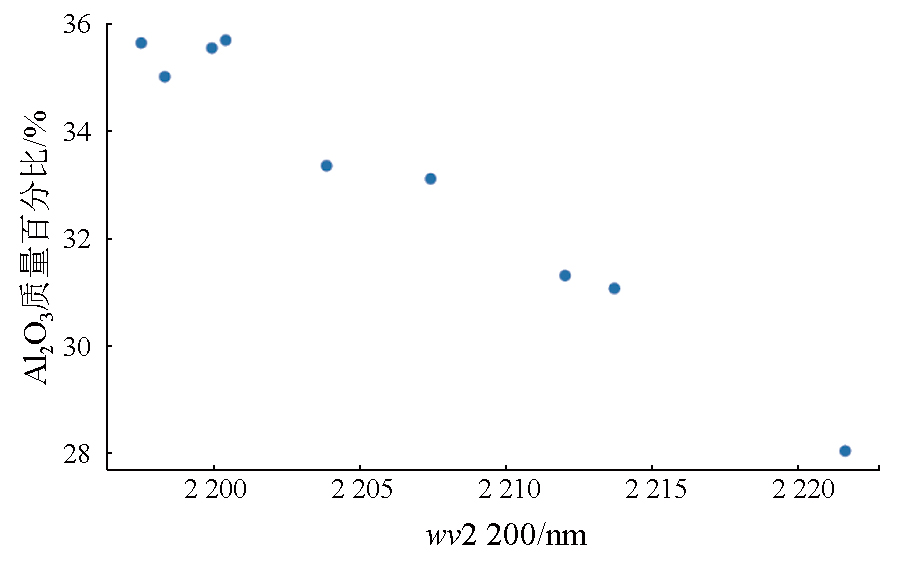
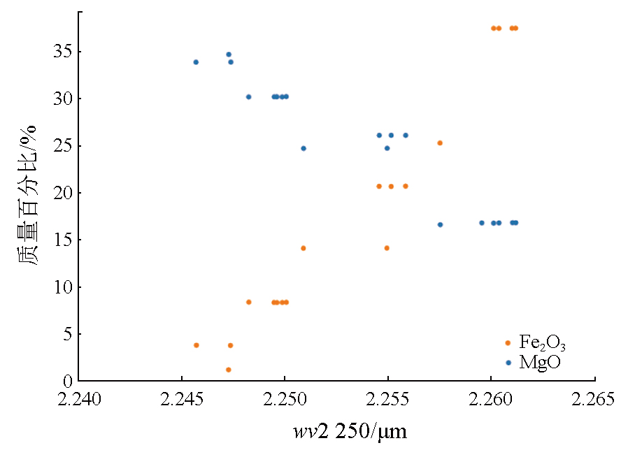
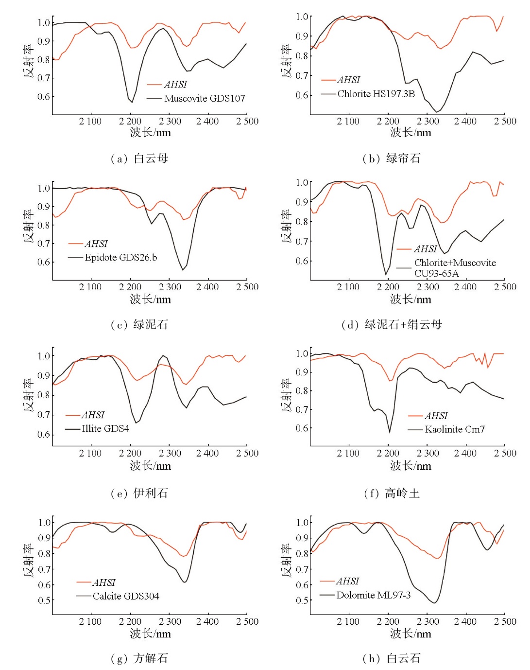
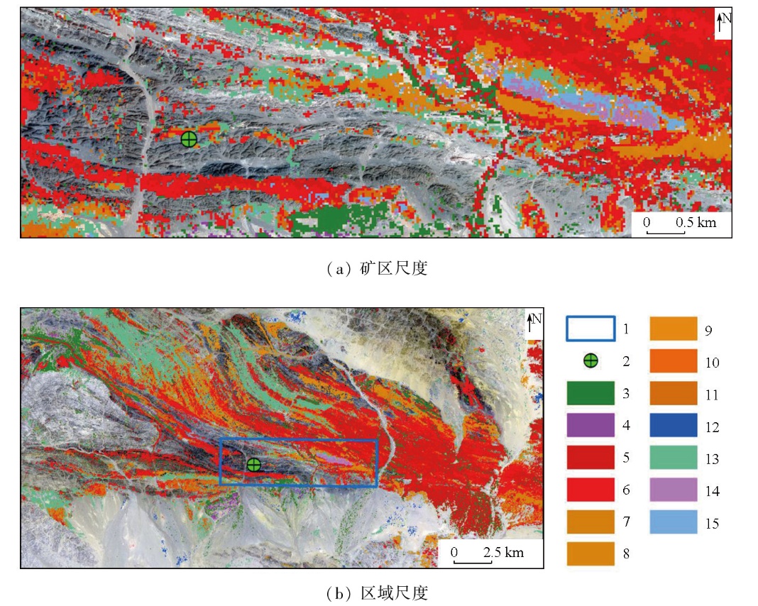
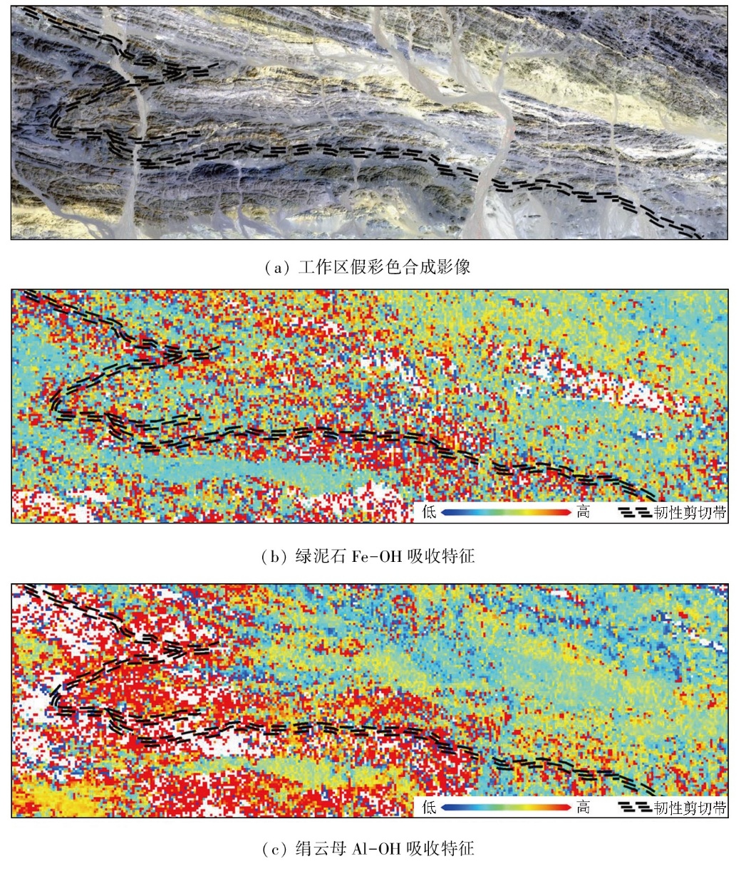
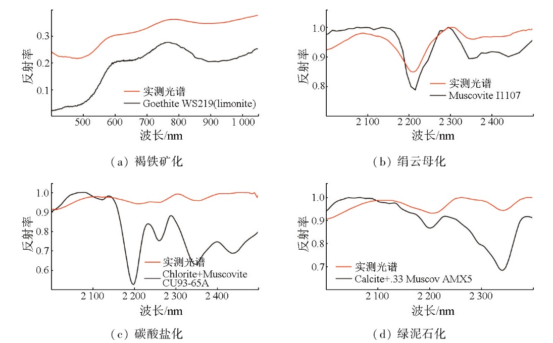
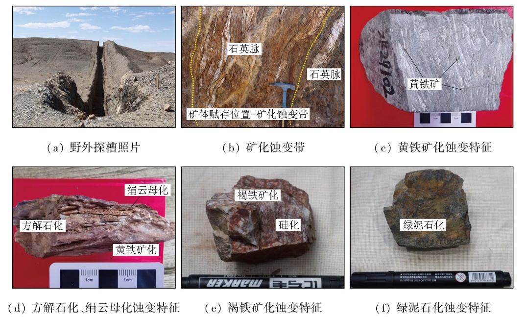
Hyperspectral remote sensing (HRS) technology,with its high spectral resolution and extensive spectral coverage,demonstrates significant potential in geological prospecting. Focusing on the Qianhongquan gold deposit in the Beishan orogenic belt,Gansu Province,this study conducted altered mineral mapping and component analysis,using HRS data from the AHSI sensor on the ZY-1 02D satellite and the self-developed hyperspectral mineral mapping technique,GeoAHSI,revealing their spatial distribution characteristics. Besides,ground-based spectral measurements were conducted on typical profiles to validate the spectral data,thereby assessing the reliability of the hyperspectral mineral mapping results. The results indicate that the primary altered minerals in the Qianhongquan gold deposit and its surrounding rocks include sericites (low-aluminum,medium-aluminum,high-aluminum,and iron-rich muscovites),calcites,dolomites,epidotes,and chlorites. Their distribution is closely related to ductile shear zones,with the distribution of sericites,chlorites,and epidotes being particularly significant within these zones. This spatial correlation provides critical indicators for regional prospecting. Additionally,it was observed that the 2 200 nm absorption feature of sericites and the 2 250 nm absorption feature of chlorites exhibit marked enrichment in silicon (Si) and iron (Fe) around ore bodies,which is closely correlated to the chemical compositions of the minerals. By enhancing the identification of weak spectral features,this study successfully applied HRS technology to mineral identification and spatial distribution analysis. These findings provide a scientific basis for further exploration of the Qianhongquan gold deposit and offer valuable references and guidance for the application of HRS in similar deposits.
何海洋, 李士杰, 秦昊洋, 刘小玉, 王思琪, 孙旭. 基于资源一号02D高光谱数据的甘肃北山前红泉地区蚀变矿物填图及特征分析[J]. 自然资源遥感, 2025, 37(5): 195-205.
HE Haiyang, LI Shijie, QIN Haoyang, LIU Xiaoyu, WANG Siqi, SUN Xu. Altered mineral mapping and characteristic analysis in Qianhongquan Area,Beishan,Gansu Province,based on hyperspectral data from the ZY-1 02D satellite. Remote Sensing for Natural Resources, 2025, 37(5): 195-205.
Gan F P, Dong X F, Yan B K, et al. Research progress of spectro-metry geological remote sensing[J]. Journal of Nanjing University of Information Science & Technology (Natural Science Edition), 2018, 10(1):44-62.
Dai J J, Zhao L X, Jiang Q, et al. Review of thermal-infrared spectroscopy applied in geological ore exploration[J]. Acta Geologica Sinica, 2020, 94(8):2520-2533.
Sun Y, Zhao Y J, Qin K, et al. Ore-forming factors and prospecting of jade ore using airborne hyperspectral data:Taken the nachitai area in Qinghai Province as an example[J]. Geological Review, 2017, 63(s1):203-204.
Zhao J Q, Dong X F, Li N, et al. Alteration characteristics and prospecting prediction of the Huaxishan gold deposit in Gansu Province based on hyperspectral data[J]. Geology and Exploration, 2023, 59(1):122-133.
Sun Y, Liu J J, Zhao Y J, et al. Alteration mineral mapping based on the GF-5 hyperspectral data and its geological application:An example of the Huaniushan area in Guazhou County of Gansu Province[J]. Geology in China, 2022, 49(2):558-574.
Wang C C, Chen C, Li Y P, et al. Hyperspectral remote sensing alteration characteristics of the Paergangtagexi porphyry copper deposit in eastern Tianshan Mountains and their indicative significance for prospecting[J]. Geology and Exploration, 2023, 59(6):1171-1181.
Sun Y, Liu J J, Zhai D G, et al. Alteration minerals mapping and identification of gold mineralization belt based on ZY1-02D hyperspectral data in the Toudiaoquan-nandatan area,Gansu Province[J]. Geology and Exploration, 2022, 58(2):399-409.
Zhao Z F, Zhang X L, Chen Q, et al. Mapping of alteration minerals and prospecting potential analysis of Pulang porphyry copper deposit:Evidence from remote sensing data of Ziyuan-1 02D satellite[J]. Sedimentary Geology and Tethyan Geology, 2022, 42(1):17-29.
Li G J, Yang X S, Zhang X, et al. Application and analysis of ZY1-02D hyperspectral data in geological and mineral survey[J]. Remote Sensing for Land and Resources, 2021, 33(2):134-140.doi:10.6046/gtzyyg.2020190.
Jiang S H, Nie F J, Hu P, et al. Discussion on the relationship of magmatism and gold metallogeny in Beishan mountain area[J]. Mineral Deposits, 2006, 25(s1):269-272.
[12]
Pan X, Liu W, Hou Z. Ore-forming fluids as sampled by sulfide- and quartz-hosted fluid inclusions in the Jinwozi lode gold deposit,eastern Tianshan Mountains of China[J]. Resource Geology, 2014, 64(3):183-208.
Yu S, Zhao B B, Jia X, et al. Geochemistry,geochronology characteristics and tectonic significance of yitiaoshan diorite in the southern margin of Beishan Orogenic Belt[J]. Northwestern Geology, 2022, 55(4):267-279.
Jiang B, Wang D H, Ma Y B, et al. Main deposit types,new deve-lopments and new directions of prospecting in Beishan region and its adjacent areas[J]. Acta Geologica Sinica, 2022, 96(6):2206-2216.
Yuan W H, Gu X X, Zhang Y M, et al. Properties of ore-forming fluids and genesis of the xiaoxigong gold deposit in the Beishan Region,Gansu Province[J]. Geoscience, 2020, 34(3):554-568.
Ding S H. 40Ar-39Ar age of sericite and its geological significance in Qianhongquan gold deposit,Beishan area,Gansu Province[J]. Gold Science and Technology, 2021, 29(2):173-183.
Wang Y X, Ma T, Zhang Y N, et al. New progress and prospecting direction of geological prospecting in the southern belt of Beishan,Gansu Province[J]. Xinjiang Geology, 2023, 41(s1):35.
Yang Z X, Ding S H, Zhang J, et al. The discovery and prospecting significance of the Qianhongquan gold deposit in the south Beishan Orogenic Belt,Gansu Province,China[J]. Northwestern Geology, 2023, 56(6):274-284.
Zhang J, Yang Z X, Chen S M, et al. Qianhongquan large gold deposit (30.6 tons) was discovered in the southern belt of Beishan,Gansu Province[J]. China Industrial Economics, 2024, 51(4):1443-1444.
Han Y, Ke Y H, Wang Z P, et al. Classification of the Yellow River Delta wetland landscape based on ZY-1 02D hyperspectral imagery[J]. National Remote Sensing Bulletin, 2023, 27(6):1387-1399.
[21]
Clark R N, Swayze G A, Livo K E, et al. Imaging spectroscopy:Earth and planetary remote sensing with the USGS Tetracorder and expert systems[J]. Journal of Geophysical Research:Planets, 2003, 108(E12):5131.
[22]
Kokaly R F, King T V V, Hoefen T M. Surface mineral maps of Afghanistan derived from HyMap imaging spectrometer data,version 2[R]. New York: U. S.Geological Survey Data, 2013.
Wang R S, Gan F P, Yan B K, et al. Hyperspectral mineral mapping and its application[J]. Remote Sensing for Land and Resources, 2010, 22(1):1-13.doi:10.6046/gtzyyg.2010.01.01.
[24]
Swayze G A, Clark R N, Goetz A F H, et al. Mapping advanced argillic alteration at cuprite,Nevada,using imaging spectroscopy[J]. Economic Geology, 2014, 109(5):1179-1221.
[25]
de Caritat P, Hutcheon I, Walshe J L. Chlorite geothermometry:A review[J]. Clays and Clay Minerals, 1993, 41(2):219-239.
[26]
Chinchilla D, Ortega L, Piña R, et al. The Patricia Zn-Pb-Ag epithermal ore deposit:An uncommon type of mineralization in northeastern Chile[J]. Ore Geology Reviews, 2016, 73:104-126.
 2025, Vol. 37
  ), 李士杰1(