Spatiotemporal evolution and trade-off/synergy analysis of ecosystem services in the Xi’an section of the Qinling Mountains
ZHANG Yiwen1(), LI Fengxia2(), ZHANG Rui1, FENG Xiaogang2, LI Meng2, HU Moqing2
1. School of Resources Engineering, Xi’an University of Architecture and Technology, Xi’an 710055, China 2. School of Architecture, Xi’an University of Architecture and Technology, Xi’an 710055, China
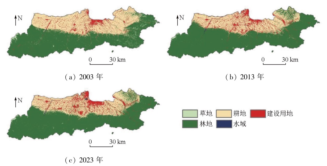
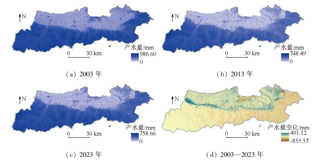
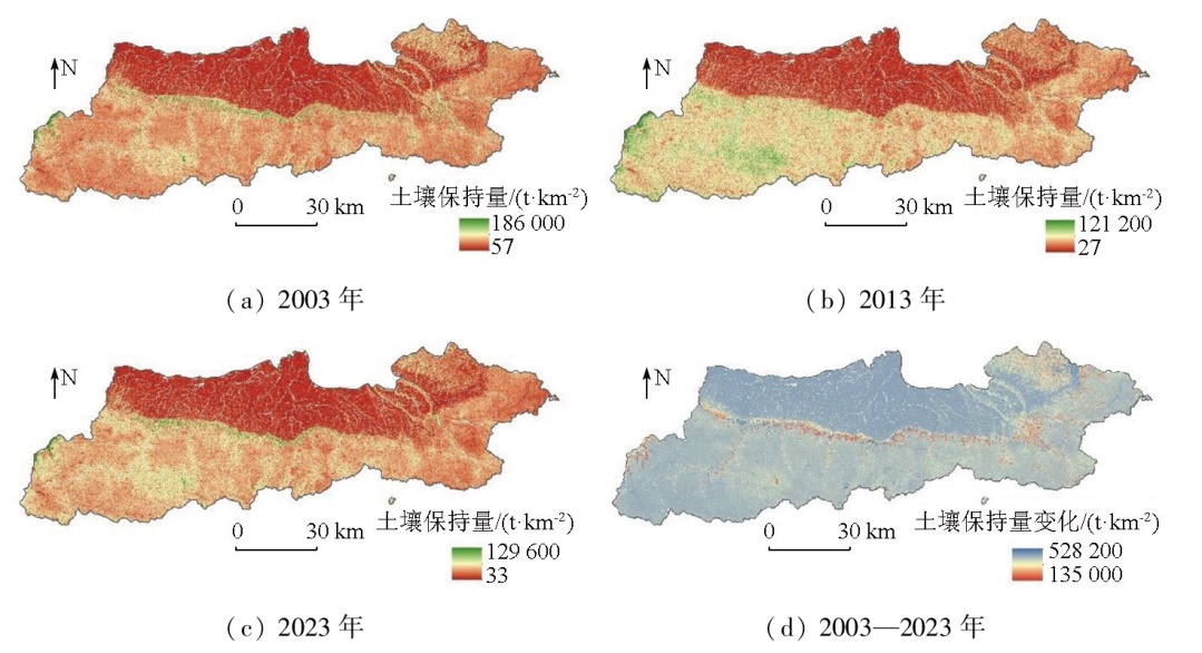
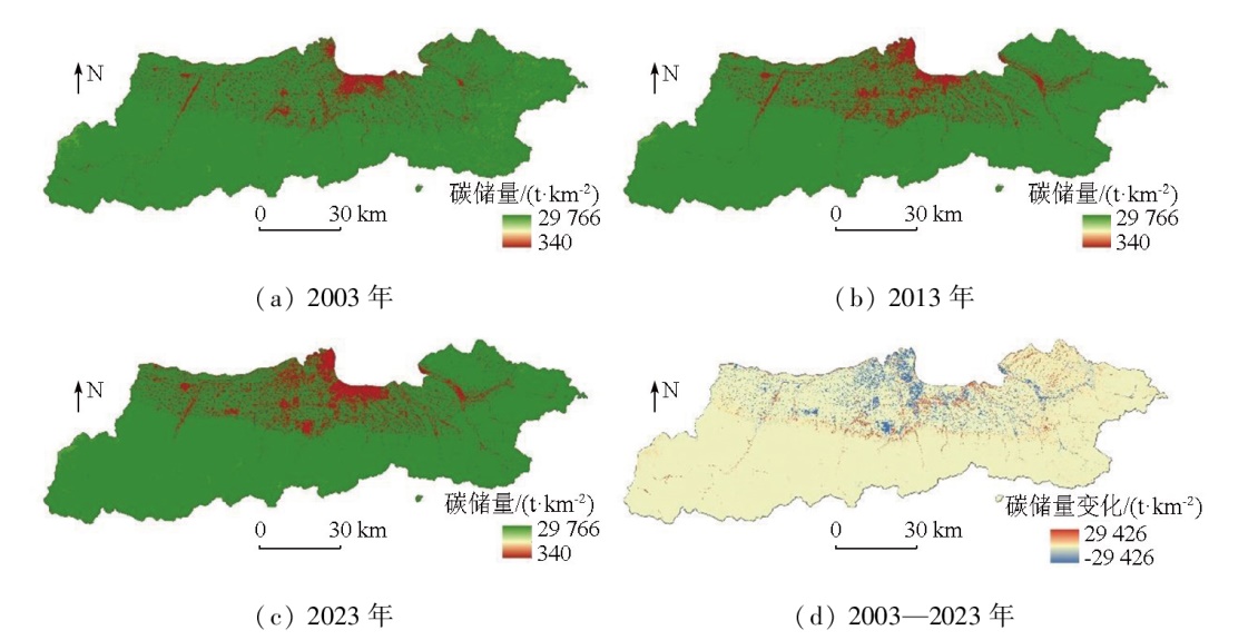
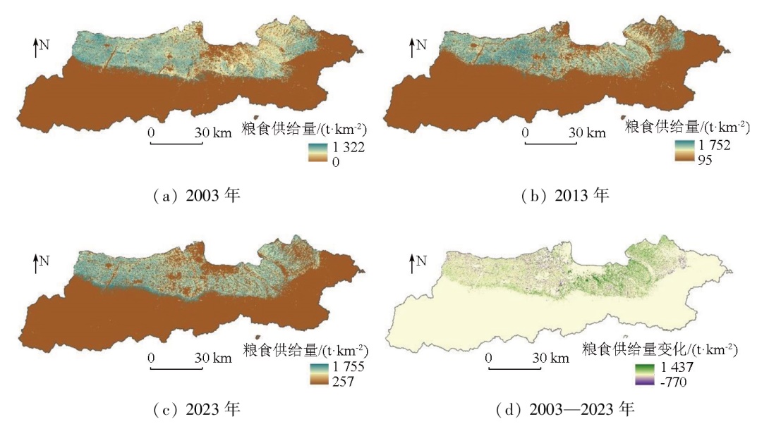
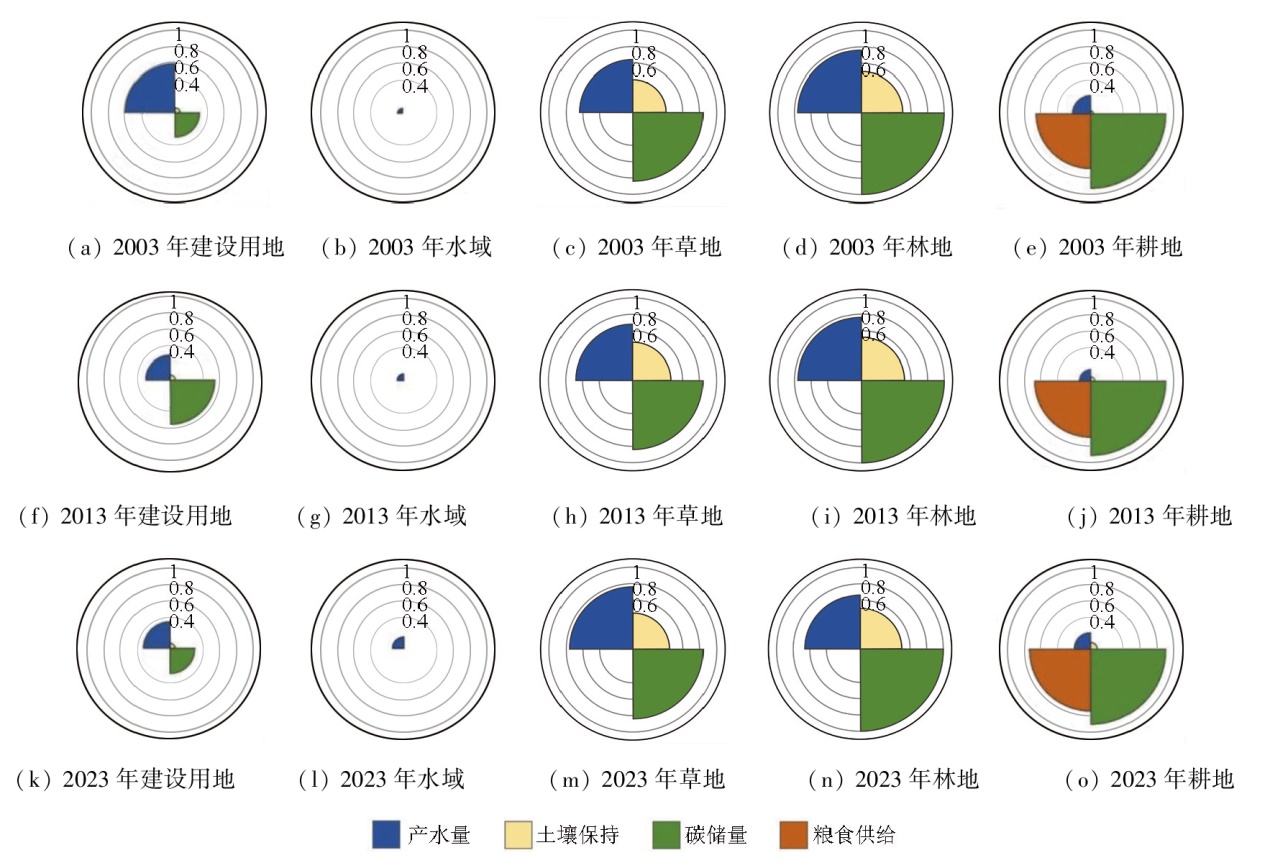
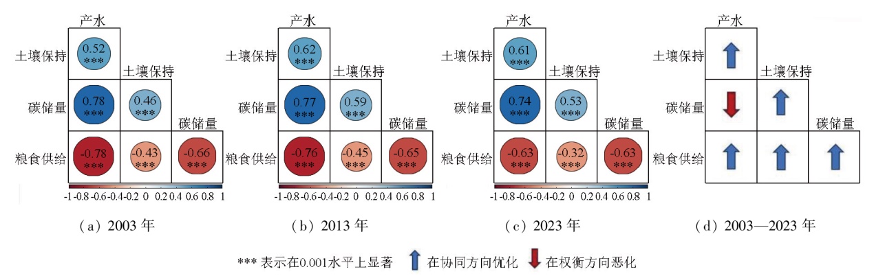
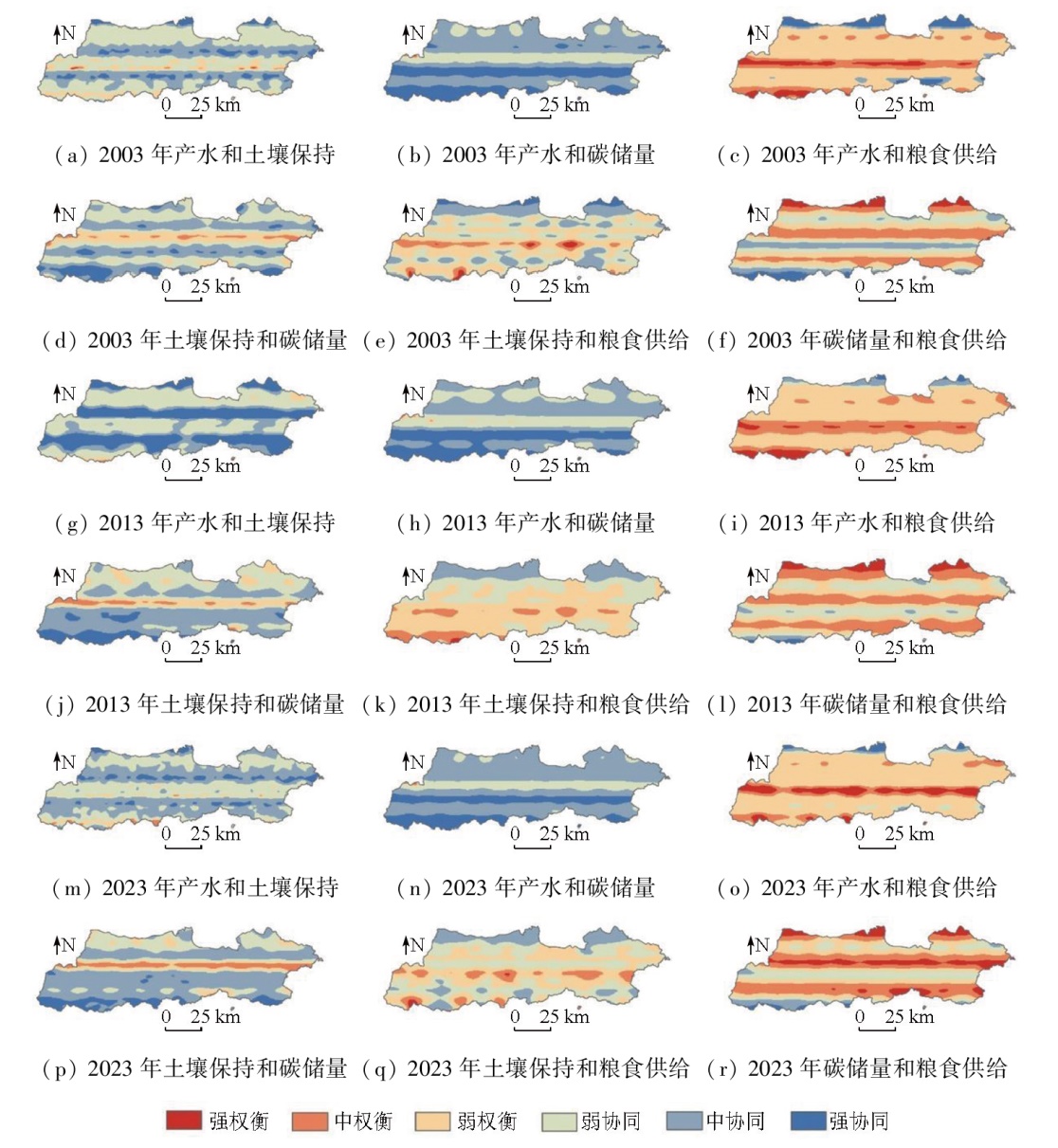
This study aims to investigate the spatiotemporal evolution and trade-off/synergy relationships of ecosystem services in the Xi'an section of the Qinling Mountains. To this end, it quantitatively assessed the spatiotemporal evolution patterns of four ecosystem services-water yield, soil conservation, carbon reserves, and food supply-from 2003 to 2023 based on the integrated valuation of ecosystem services and trade-offs (InVEST) model. By integrating Spearman's rank correlation coefficient and geographically weighted regression (GWR), this study identified and quantified trade-off/synergy relationships among ecosystem services. Finally, the impacts of changes in land use on ecosystem services were analyzed. The results showed that water yield and soil conservation generally showed a rapidly decreasing trend followed by a slow increase, while carbon reserves and food supply exhibited a slow decline. In addition, synergistic relationships were observed between water yield and soil conservation, between water yield and carbon reserves, and between carbon reserves and soil conservation. In contrast, trade-off relationships were identified between food supply and water production, soil conservation, and carbon reserves. In the study area, increases in forestland and grassland led to a diminution in water yield. The expansion of construction land and the loss of arable land resources directly triggered a reduction in carbon reserves, while an increase in forestland contributed to soil conservation. These findings can provide a scientific basis for the eco-environmental protection and sustainable development of the Qinling area.
张怡雯, 李凤霞, 张睿, 冯晓刚, 李萌, 胡墨清. 秦岭西安段生态系统服务时空演变与权衡/协同分析[J]. 自然资源遥感, 2025, 37(6): 191-200.
ZHANG Yiwen, LI Fengxia, ZHANG Rui, FENG Xiaogang, LI Meng, HU Moqing. Spatiotemporal evolution and trade-off/synergy analysis of ecosystem services in the Xi’an section of the Qinling Mountains. Remote Sensing for Natural Resources, 2025, 37(6): 191-200.
Fu B J, Zhou G Y, Bai Y F, et al. The main terrestrial ecosystem services and ecological security in China[J]. Advances in Earth Science, 24(6):571-576.
Dai E F, Wang X L, Zhu J J, et al. Progress and perspective on ecosystem services trade-offs[J]. Advances in Earth Science, 2015, 30(11):1250-1259.
doi: 10.11867/j.issn.1001-8166.2015.11.1250
Wang J Q. Study on the evaluation of land use efficiency in the town of southeast coastal areas:In case of the top 100 counties in Zhejiang[D]. Ningbo: Ningbo University, 2014.
[4]
Song W, Deng X Z. Land-use/land-cover change and ecosystem service provision in China[J]. Science of The Total Environment, 2017,576:705-719.
[5]
Shifaw E, Sha J M, Li X M, et al. Ecosystem services dynamics and their influencing factors:Synergies/tradeoffs interactions and implications,the case of upper Blue Nile Basin,Ethiopia[J]. Science of The Total Environment, 2024,938:173524.
[6]
Xia H, Yuan S F, Prishchepov A V. Spatial-temporal heterogeneity of ecosystem service interactions and their social-ecological drivers:Implications for spatial planning and management[J]. Resources,Conservation and Recycling, 2023,189:106767.
[7]
Zhang J W, Wang M, Liu K, et al. Social-ecological system sustainability in China from the perspective of supply-demand balance for ecosystem services[J]. Journal of Cleaner Production, 2025,497:145039.
Yu Y, Han L, Li M Y, et al. Study on the spatial-temporal characteristics of ecosystem services and tradeoffs/synergies in the Ha-Chang urban agglomeration[J]. Research of Soil and Water Conservation, 2021, 28(2):293-300.
Long W Q, Zhi L, Guo Y D, et al. Spatiotemporal evolution and origin of carbon stock in the West Dongting Lake National Nature Reserve over the last two decades[J]. Remote Sensing for Natural Resources, 2024, 36(4):185-192.doi:10.6046/zrzyyg.2023265.
[10]
崔璐. 秦岭陕西段生态系统服务评估及多情景预测研究[D]. 西安: 长安大学, 2023.
Cui L. Ecosystem service assessment and multi-scenario prediction in the Shaanxi section of the Qinling Mountains[D]. Xi’an: Chang’an University, 2023.
Qiu H H, Hu B Q, Zhang Z. Study on ecosystem service value of Guangxi in the past 20 years based on land use change[J]. Journal of Environmental Engineering Technology, 2022, 12(5):1455-1465.
Li D, Zhou J, Zhan D Q. Spatial and temporal changes and driving factors of cultivated land in Heilongjiang Province[J]. Scientia Geographica Sinica, 2021, 41(7):1266-1275.
doi: 10.13249/j.cnki.sgs.2021.07.017
Niu L L, Zhang B C, Jia T Z, et al. Analysis on intensity and stabi-lity of land use change in Haixi Mongolian and Tibetan Autonomous Prefecture of Qinghai Province[J]. Journal of Soil and Water Conservation, 2021, 35(2):152-159.
Zhu L W, Chen C, Peng Y F, et al. A study on spatiotemporal evolution patterns of cultivated land based on LUCC intensity chroma-togram[J]. Natural Resource Economics of China, 2024, 37(12):52-63.
Li S C, Gong J, Yang J X, et al. Characteristics of LUCC patterns of the Lanzhou-Xining urban agglomeration:Based on an intensity analysis framework[J]. Resources Science, 2023, 45(3):480-493.
doi: 10.18402/resci.2023.03.02
Fan Y N, Liu K, Chen S S, et al. Spatial pattern analysis on water conservative functionality of land ecosystem in northern slope of Qinling Mountains[J]. Bulletin of Soil and Water Conservation, 2017, 37(2):50-56.
Zhou P P, Luo Y, Song X Y, et al. Estimation and prediction of water conservation capacity in Shaanxi Province based on the InVEST-PLUS model[J]. Journal of Soil and Water Conservation, 2024, 38(3):187-194.
Zhai R J, Zhao W W, Jia L Z. A comparative study of soil erosion estimation based on RUSLE,InVEST and USPED models:A case study of Yanhe River Basin in Northern Shaanxi[J]. Research of Agricultural Modernization, 2020, 41(6):1059-1068.
Li Q, Wang C J, Feng T, et al. Multi-scenario prediction of land use change and carbon storage in Shaanxi Province based on the SD-PLUS coupled model[J]. Journal of Soil and Water Conservation, 2024, 38(3):195-206,215.
Zhao W L, He Z, He J P, et al. Remote sensing estimation for winter wheat yield in Henan based on the MODIS-NDVI data[J]. Geographical Research, 2012, 31(12):2310-2320.
Zhou F, Zhou D M, Jin Y L, et al. Spatial matching characteristics of supply and demand of ecosystem services in the Shule River Basin[J]. Arid Land Geography, 2023, 46(3):471-480.
doi: 10.12118/j.issn.1000-6060.2022.337
Wu W H, Peng J, Liu Y X, et al. Tradeoffs and synergies between ecosystem services in Ordos City[J]. Progress in Geography, 2017, 36(12):1571-1581.
doi: 10.18306/dlkxjz.2017.12.012
Liu J Y, Ning J, Kuang W H, et al. Spatio-temporal patterns and characteristics of land-use change in China during 2010—2015[J]. Acta Geographica Sinica, 2018, 73(5):789-802.
Wei P J, Wu M H, Jia Y L, et al. Spatiotemporal variation of water yield in the upstream regions of the Shule River Basin using the InVEST Model[J]. Acta Ecologica Sinica, 2022, 42(15):6418-6429.
Hu W M, Yang R H, Jia G Y, et al. Response of water yield function to land use change and its driving factors in the Yangtze River Basin[J]. Acta Ecologica Sinica, 2022, 42( 17) :7011-7027.
Jia J A, Guo W L, Xu L Y, et al. Spatio-temporal evolution and driving force analysis of carbon storage in Anhui Province coupled with PLUS-InVEST-GeoDetector model[J]. Environmental Science, 2025, 46(3):1703-1715.
[27]
Martens B, Miralles D G, Lievens H, et al. GLEAM v4.2a:Global land evaporation amsterdam model dataset[EB/OL].[2025-04-01].https://www.gleam.eu.
 2025, Vol. 37
  ), 李凤霞2(