Using Sentinel-1 multi-temporal InSAR data to monitor the damage degree of shoot beetle in Yunnan pine forest
Juan XUE1, Linfeng YU1, Qinan LIN1, Guang LIU2, Huaguo HUANG1()
1. Key Laboratory for Silviculture and Conservation of Ministry of Education, Beijing Forestry University, Beijing 100083, China 2. Institute of Remote Sensing and Digital Earth, Chinese Academy of Sciences, Beijing 100094, China
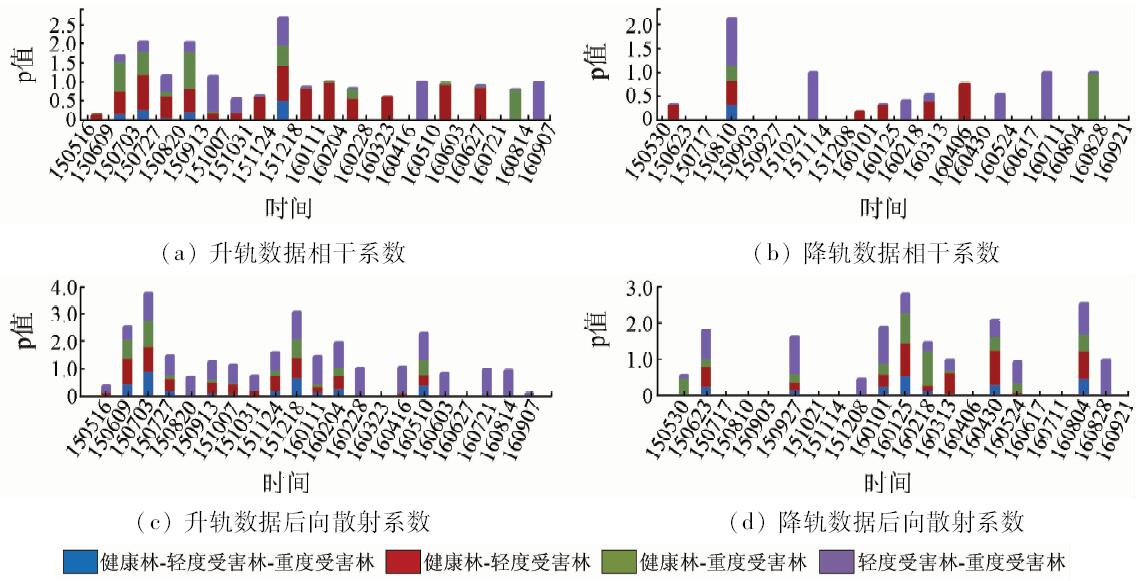
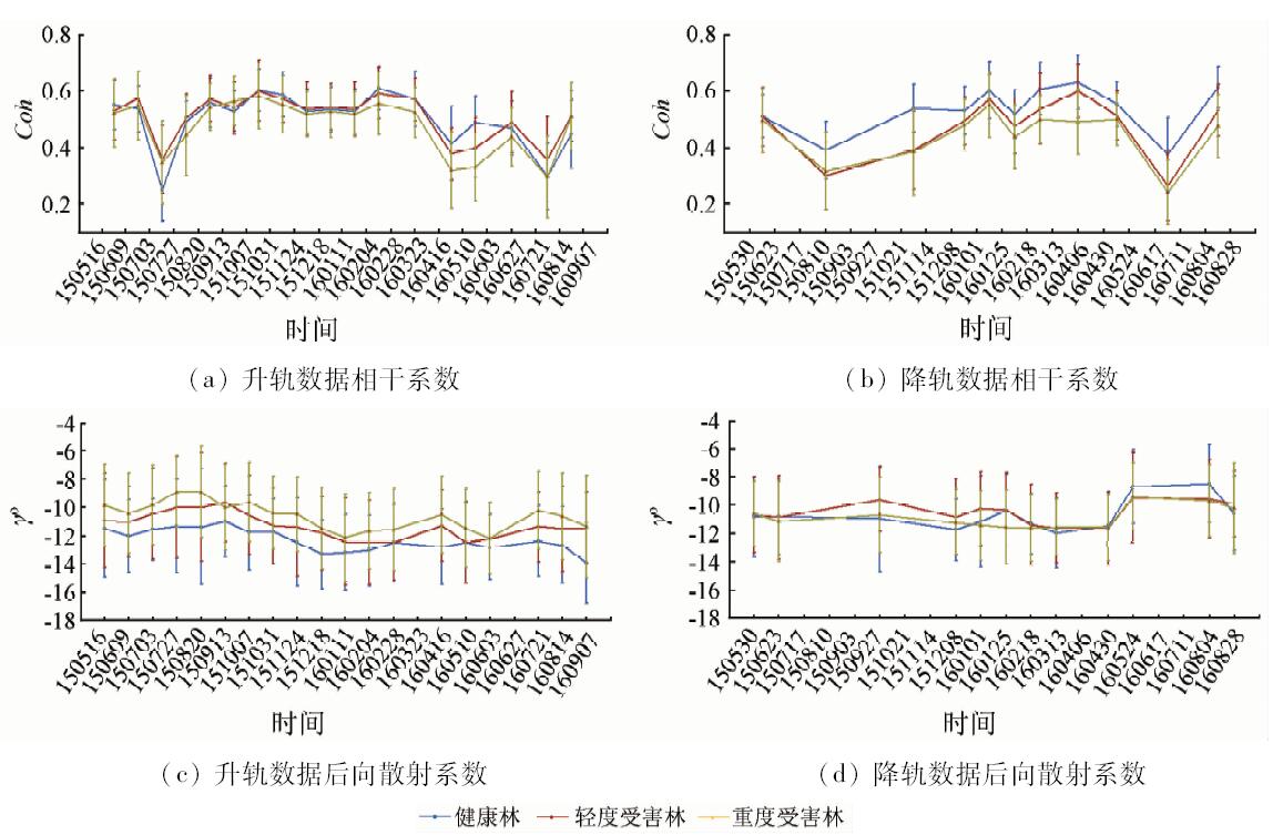
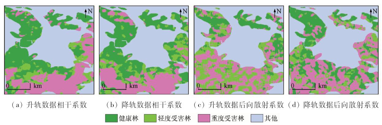
Forest pests constitute one of the important threats to the healthy growth of forests, and the monitoring of its damage is of great significance to forest protection. In this paper, a method of monitoring the degree of forest pests by using interferometric synthetic aperture Radar (InSAR) is proposed. Xiangyun County of Yunnan Province was selected as the study area and the multi-temporal C-band Sentinel-1 images were applied. Based on the information of Radar backscattering intensity, interference phase and coherence coefficient, the time-varying characteristics of coherence coefficient and backscattering coefficient were analyzed by combining the phenological phase of Yunnan pine and relative humidity in the height of 2 meters. Fusion of multi-temporal data was applied to the classification of health forest and different degrees of damaged forest. Some conclusions have been reached: ① The temporal variation of the backscattering coefficient and the coherence coefficient are related to the phenological phenology of Yunnan pine. ② The correlation between the relative humidity and backscattering coefficient is higher than coherence coefficient, which reaches 0.78 in the mildly damaged forest. ③ Field data validation shows that classification accuracy of the multi-temporal coherence coefficient is higher than the backscattering coefficient, and the descending image has the highest precision which reaches 83.15%. The result shows that the coherence coefficient of C-band SAR time series can effectively identify the problem as to whether the forest is healthy or suffers different degrees of damage. ④ The method has certain advantages in monitoring and classification of forest pests in cloudy areas as well as in further enhancing the capability of remote sensing on monitoring pests.
薛娟, 俞琳锋, 林起楠, 刘广, 黄华国. 基于Sentinel-1多时相InSAR影像的云南松切梢小蠹危害程度监测[J]. 国土资源遥感, 2018, 30(4): 108-114.
Juan XUE, Linfeng YU, Qinan LIN, Guang LIU, Huaguo HUANG. Using Sentinel-1 multi-temporal InSAR data to monitor the damage degree of shoot beetle in Yunnan pine forest. Remote Sensing for Land & Resources, 2018, 30(4): 108-114.
Wu L P, Ji Z R, Lian S L , et al. Probability analysis of forest pests occurring risk in Fujian Province[J]. Journal of Forest and Environment, 2017,37(1):95-101.
Wang Z, Cao J, Cao Q C , et al. Feasibility of monitoring chestnut diseases and pests with hyper spectral remote sensing[J]. Chinese Agricultural Science Bulletin, 2010,26(13):380-384.
[4]
王晓堂 . 基于高光谱的松萎蔫病动态变化的研究[D]. 南京:南京林业大学, 2011.
Wang X T . Research on Dynamie Changes of Pine Wilt Disease Based on Hyperspectral[D]. Nanjing:Nanjing Forestry University, 2011.
Wang X S, Chen E X, Li Z Y , et al. Multi-temporal and dual-polarization SAR for forest land type classification[J].Scientia Sil-vae Sinicae. 2014,50(3):83-91
Peng L, Yang W N, Huang J . Study of land cover classification using multi-temporal InSAR data in west plateau of Sichuan[J]. Journal of Southwest University(Natural Science Edition), 2016,38(5):125-132.
Lu R C . Study on the Ecology of Tomicus Yunnanensis and Tominus Minor(Coleoptera: Scolytidae)and Their Kairomones[D]. Beijing:Beijing Forestry University, 2008.
Li Y . Causes of Tomicus piniperda L.disaster in Yuxi of Yunnan Province and countermeasures of prevention and control[J]. Forest Resources Management, 2013,35(3):40-42.
Zeng L F, Li L, Wang L H . SAR-based fast flood mapping using Sentinel-1 imagery[J]. Geomatics World, 2015,22(5):100-103,107.
[12]
Ardhuin F, Collard F, Chapron B , et al. Estimates of ocean wave heights and attenuation in sea ice using the SAR wave mode on Sentinel-1A[J]. Geophysical Research Letters, 2015,42(7):2317-2325.
doi: 10.1002/2014GL062940
[13]
Wang X, Ge L L, Li X J . Pasture monitoring using SAR with COSMO-SkyMed,ENVISAT ASAR,and ALOS PALSAR in Otway,Australia[J]. Remote Sensing, 2013,5(7), 3611-3636.
doi: 10.3390/rs5073611
Xu Z H, Liu J, Chen C C , et al. Canopy spectral characteristics distinguishability analysis of Pinus massoniana forests with Dendrolimus punctatus Walker damage[J]. Remote Sensing for Land and Resources, 2016,28(2):41-47.doi: 10.6046/gtzyyg.2016.02.07.
 2018, Vol. 30
  )
)