Medium resolution remote sensing based winter wheat mapping corrected by low-resolution time series remote sensing images
Shuang ZHU1,2, Jinshui ZHANG2,3,4()
1. Beijing Polytechnic College, Beijing 100042, China 2. State Key Laboratory of Earth Surface Processes and Resource Ecology, Beijing Normal University, Beijing 100875, China 3. Beijing Engineering Research Center for Global Land Remote Sensing Products, Faculty of Geographical Science, Beijing Normal University, Beijing 100875, China 4. Institute of Remote Sensing Science and Engineering, Faculty of Geographical Science, Beijing Normal University, Beijing 100875, China
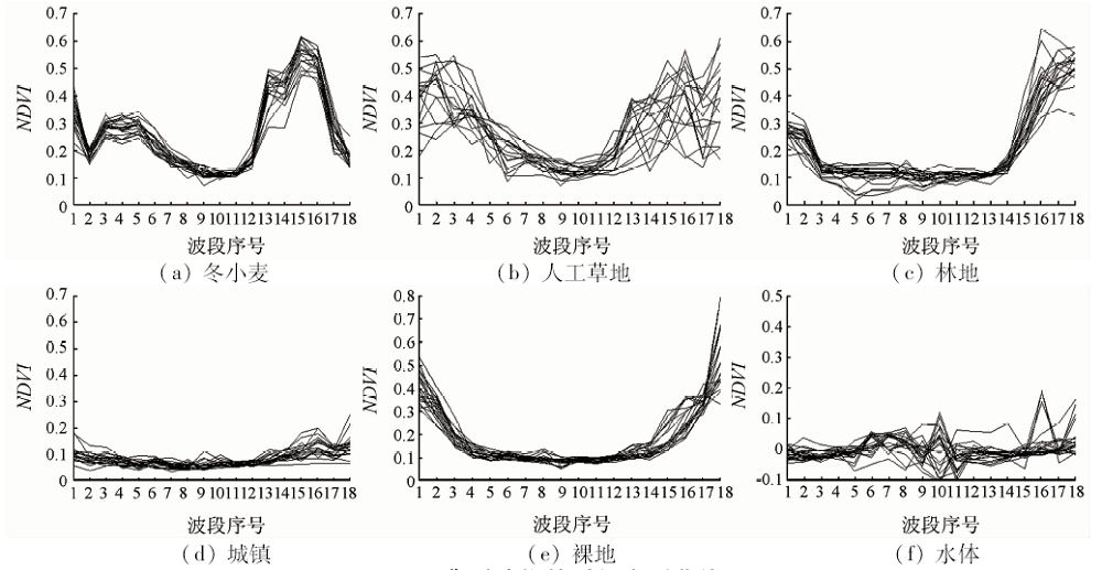
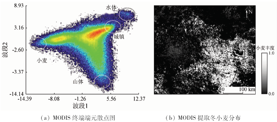
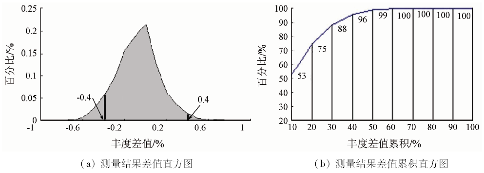
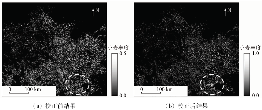
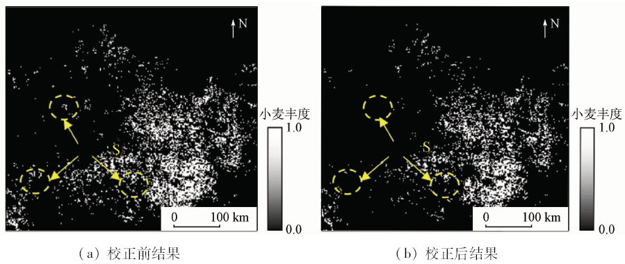
Owing to influences of the same spectrum with the different thing and the same thing with the different spectrum, the medium resolution remotely sensed image, Landsat8 OLI, extracts the wheat extraction with the wrong information, which leads to low accuracy. The coarse resolution image with multi-temporal trait can discriminate the wheat information from other similar land cover. In this paper, the multi-temporal trait is adopted to solve the “wrong coming or wrong going” error of the OLI classification so as to increase the wheat extraction accuracy. The experiment shows that the OLI and MODIS can extract the wheat with high consistence, so the result of MODIS can correct the error of the OLI, where the phenomenon of the same spectrum with the different thing and the same thing with the different spectrum occurs. In the region of the same thing with different spectrum, the RMSE of OLI result is 0.758, while that of the MODIS correction result is 0.142. In the region of the different thing with the same spectrum, the RMSE of OLI result is 0.901, while that of the MODIS correction result is 0.122. All the results show that the MODIS result can correct OLI result for higher wheat extraction accuracy, which can solve the phenomenon of the same spectrum with the different thing and the same thing with the different spectrum.
Wang L M, Liu J, Yang L B , et al. Impact of short infrared wave band on identification accuracy of corn and soybean area[J]. Transactions of the Chinese Society of Agricultural Engineering, 2016,32(19):169-178.
Zhu S, Zhang J S, Cui Y Z . Soft and hard change region identification of crop by profile based gradient change magnitude method[J]. Chinese Journal of Agricultural Resources and Regional Planning. 2018,39(7):38-42
[4]
Pan Y Z, Hu T G, Zhu X F , et al. Mapping cropland distributions using a hard and soft classification model[J]. IEEE Transactions on Geoscience and Remote Sensing, 2012,50(11):4301-4312.
[5]
Prakash A, Gupta R P . Land-use mapping and change detection in a coal mining area:A case study in the Jharia coalfield,India[J]. International Journal of Remote Sensing, 1998,19(3):391-410.
[6]
Weismiller R A, Kristof S J, Scholz D K , et al. Change detection in coastal zone environments[J]. Photogrammetric Engineering and Remote Sensing, 1977,43(12):1533-1539.
[7]
Bruzzone L, Prieto D F . A minimum-cost thresholding technique for unsupervised change detection[J]. International Journal of Remote Sensing, 2000,21(18):3539-3544.
Li L L, Pan Y Z, Zhang J S , et al. Method of winter wheat planting area estimation based on support vector machine and post-classification changed vector analysis[J]. Transactions of the Chinese Society of Agricultural Engineering, 2010,26(9):210-217.
Zhu S, Zhang J S . Impact of land fragmentation on identification of winter wheat distribution accuracy by soft and hard change detection method[J]. Transactions of the Chinese Society of Agricultural Engineering, 2016,32(10):164-171.
[10]
Stefanov W L, Ramsey M S, Christensen P R . Monitoring urban land cover change:An expert system approach to land cover classification of semiarid to arid urban centers[J]. Remote Sensing of Environment, 2001,77(2):173-185.
Zhao M, Zhao Y D . Object-oriented and multi-feature hierarchical change detection based on CVA for high-resolution remote sensing imagery[J]. Journal of Remote Sensing, 2018,22(1):119-131.
Xie D F, Zhang J S, Pan Y Z , et al. Fusion of MODIS and Landsat8 images to generate high spatial-temporal resolution data for mapping autumn crop distribution[J]. Journal of Remote Sensing, 2015,19(5):791-805.
[13]
Yu W Y, Qi Y B, Wei F , et al. The impact of FDD rotation mode and irrigation methods on rice irrigation water efficiency in southwestern China[J]. Resources Science, 2017,39(6):1127-1136.
Ren J Q, Chen Z X, Zhou Q B , et al. MODIS vegetation index data used for estimating corn yield in USA[J]. Journal of Remote Sensing, 2015,19(4):568-577.
Gu X H, Pan Y Z, Zhu X F , et al. Consistency study between MODIS and OLI on winter wheat plant area monitoring:A case in small area[J]. Journal of Remote Sensing, 2007,11(3):350-358.
Zhu S, Zhang J S, Shuai G Y , et al. Winter wheat mapping by soft and hard land use/cover change detection[J]. Journal of Remote Sensing, 2014,18(2):476-496
[17]
Mountrakis G, Im J, Ogole C . Support vector machines in remote sensing:A review[J]. ISPRS Journal of Photogrammetry and Remote Sensing, 2011,66(3):247-259.
[18]
Zhang L F, Jiao W Z, Zhang H M , et al. Studying drought phenomena in the continental United States in 2011 and 2012 using various drought indices[J]. Remote Sensing of Environment, 2017,190:96-106.
[19]
Amani M, Salehi B, Mahdavi S , et al. Temperature-vegetation-soil moisture dryness index (TVMDI)[J]. Remote Sensing of Environment, 2017,197:1-14.
[20]
Wang L J, Guo N, Wang X P , et al. Effects of spatial resolution for evapotranspiration estimation by using the triangular method over heterogeneous underling surface[J]. IEEE Journal of Selected Topics in Applied Earth Observations and Remote Sensing, 2017,10(6):2518-2527.
[21]
Ghaffari O, Zoej M J V, Mokhtarzade M . Reducing the effect of the endmembers’ spectral variability by selecting the optimal spectral bands[J]. Remote Sensing, 2017,9(9):99-112.
[22]
Bangira T, Alfieri S M, Menenti M , et al. A spectral unmixing method with ensemble estimation of endmembers:Application to flood mapping in the Caprivi floodplain[J]. Remote Sensing, 2017,9(10):472-484.
[23]
Ma T, Li R, Svenning J , et al. Linear spectral unmixing using endmember coexistence rules and spatial correlation[J]. International Journal of Remote Sensing, 2018,39(11):3512-3536.
Lan J H, Zou J L, Hao Y S , et al. Research progress on unmixing of hyperspectral remote sensing imagery[J]. Journal of Remote Sensing, 2018,22(1):13-27.
Zhang C L, Zheng Y W, Huang X B , et al. Hyperspectral image classification based on weighted probabilistic fusion of multiple spectral-spatial features[J]. Acta Geodaetica et Cartographica Sinica, 2015,44(8):909-918.
 2020, Vol. 32
  )
)