1. School of Earth Sciences and Resources, China University of Geosciences, Beijing 100083, China 2. Beijing Municipal Commission of Transport, Beijing 100073, China 3. Hebei Hydrological Engineering Geological Exploration Institute, Shijiazhuang 050021, China 4. China Aero Geophysical Survey and Remote Sensing Centre for Natural Resources, Beijing 100083, China
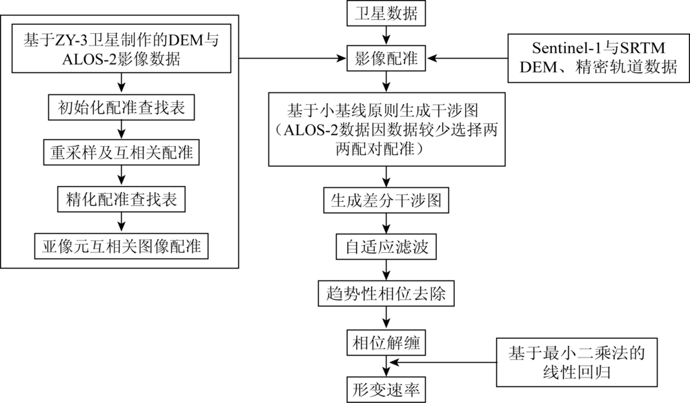
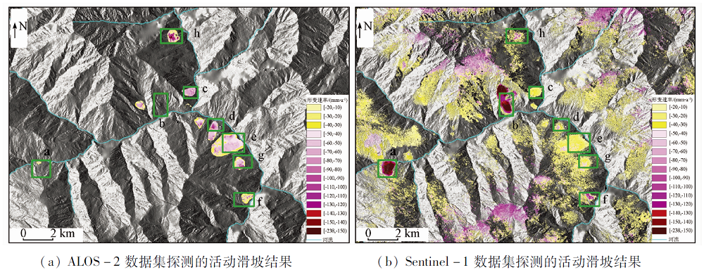
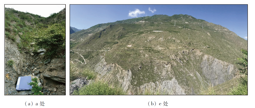
Based on satellite images of two different wavelengths acquired by ALOS-2 and Sentinel-1, the authors used DInSAR two-track method and stacking technology to analyze and delineate the active landslide that is undergoing surface deformation in the central part of Maoxian County, Sichuan Province. First, in view of the long time baseline of the ALOS-2 satellite and the small amount of image data, the two-track DInSAR method was used to detect landslide deformation. Secondly, on the basis of the short-time baseline multi-scene Sentinel-1 data, the stacking technology was used to detect landslide deformation. Finally, comprehensive analysis of the deformation rate results of the two data sets was conducted, and the potential landslide area in the middle of Maoxian County of Sichuan was delineated. The results show that the suspected active landslides in Baibu Village of Maoxian County and other places have obvious surface deformation, and the maximum absolute amount of radar line-of-sight deformation rate reaches 200 mm/a; combined with optical image characteristics and existing historical survey data, 8 active landslides were delineated, and the exploration result of two kinds of data shows that the detection results of the data can correspond to each other in the spatial distribution of 7 active landslides. Field surveys were conducted on 6 active landslides, and signs of ground deformation were found. The work in this paper shows that using a small number of long-band ALOS-2 images and the DInSAR two-track method can detect more obvious landslide surface deformation in mountainous areas with certain vegetation coverage; when C-band Sentinel-1 images are applied, accumulation of continuous multi-scene data is required; in addition, by applying time series analysis method, the detection effect is better than the two-track method using ALOS-2 images.
基金资助:国家自然科学基金项目“青藏高原露天煤矿排土场地形-土壤-植被响应机理及地貌重塑研究”(41977415);中国地质调查局项目“全球冰川及荒漠化遥感地质调查”(DD20190515);中欧科技合作“龙计划”五期项目“Integration of multi-source Remote Sensing Data to detect and monitoring large and rapid landslides and use of Artificial Intelligence for Cultural Heritage preservation”(56796);JAXA EO-RA2项目“Application of Radar Remote Sensing Technology in Resource Environment Monitoring”(P3073002)
张腾, 谢帅, 黄波, 范景辉, 陈建平, 童立强. 利用Sentinel-1和ALOS-2数据探测茂县中部活动滑坡[J]. 国土资源遥感, 2021, 33(2): 213-219.
ZHANG Teng, XIE Shuai, HUANG Bo, FAN Jinghui, CHEN Jianping, TONG Liqiang. Detection of active landslides in central Maoxian County using Sentinel-1 and ALOS-2 data. Remote Sensing for Land & Resources, 2021, 33(2): 213-219.
Shao C J, Li F Y, Li Y, et al. Sliding mechanism of Maoxian landslide and geological condition analysis of formation of post-earthquake landslide[J]. Journal of Chengdu University of Technology(Science & Technology Edition), 2017, 44(4):385-402.
Fan J H. InSAR monitoring and synthetic analysis of the surface deformation of Fanjiaping landslide in the Three Gorges Reservoir area[J]. Geological Bulletin of China, 2017, 36(9):1665-1673.
[3]
Liu G, Guo H, Perski Z, et al. Landslide movement monitoring with ALOS-2 SAR data[J]. IOP Conference Series Earth and Environmental Science, 2019, 227:062015.
doi: 10.1088/1755-1315/227/6/062015
Wang Z L, Liao M S, Zhang L, et al. Detecting and characterizing deformations of the left bank slope near the Jinping hydropower station with time series Sentinel-1 data[J]. Remote Sensing for Land and Resources, 2019, 31(2):204-209.doi: 10.6046/gtzyyg.2019.02.28.
doi: 10.6046/gtzyyg.2019.02.28
[5]
Intrieri E, Raspini F, Fumagalli A, et al. The Maoxian landslide as seen from space:Detecting precursors of failure with Sentinel-1 data[J]. Landslides, 2017, 15(3):1-10.
Gao S Y, Huang S F, Sun Y Y, et al. Research on the application of Sentinel-1 SAR data in monitoring of landslide disaster in Maoxian County Sichuan[J]. Journal of China Institute of Water Resources and Hydropower Research, 2019, 17(2):132-138.
Xu Q, Li W L, Dong X J, et al. The Xinmocun landslide on June 24,2017 in Maoxian,Sichuan:Characteristics and failure mechanism[J]. Chinese Journal of Rock Mechanics and Engineering, 2017, 36(11):2612-2628.
Wen M S, Chen H Q, Zhang M Z, et al. Characteristics and formation mechanism analysis of the “6·24” catastrophic landslide of the June 24 of 2017,at Maoxian,Sichuan[J]. The Chinese Journal of Geological Hazard and Control, 2017, 28(3):1-7.
[9]
Liang C, Liu Z, Fielding E J, et al. InSAR time series analysis of L-band wide-swath SAR data acquired by ALOS-2[J]. IEEE Transactions on Geoscience and Remote Sensing, 2018, 56(8):4492-4506.
doi: 10.1109/TGRS.2018.2821150
[10]
Dong Y, Chen W, Chang H, et al. Assessment of orthoimage and DEM derived from ZY-3 stereo image in Northeastern China[J]. Survey Review, 2016, 48(349):247-257.
doi: 10.1179/1752270615Y.0000000027
Li J Q, Han H H, Gao T, et al. The application of ZY-3 satellite to geological hazards survey and evaluation:A case study of Baoji loess area[J]. Remote Sensing For Land and Resources, 2017, 29(s1):73-80.doi: 10.6046/gtzyyg.2017.s1.12.
doi: 10.6046/gtzyyg.2017.s1.12
Zhang X B, Zhao X S, Ge D Q, et al. Subsidence monitoring of Huainan coal mine from Sentinel TOPS images based on Stacking technique[J]Remote Sensing for Land and Resources, 2018, 30(4):200-205.doi: 10.6046/gtzyyg.2018.04.30.
doi: 10.6046/gtzyyg.2018.04.30
Zheng W J, Sun Q, Liu X G. Monitoring landslide movements in Xingpeidang-Caokedu section of middle Jinsha River with TCP-InSAR and Sentinel-1 data1[J]. Engineering of Surveying and Mapping, 2018, 27(9):51-58,63.
 2021, Vol. 33
  ), 谢帅2, 黄波3, 范景辉4(