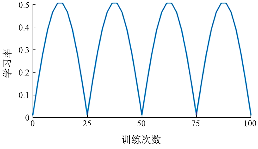
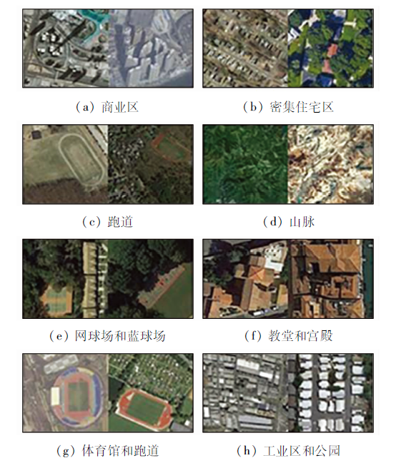
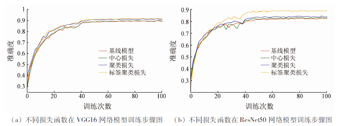
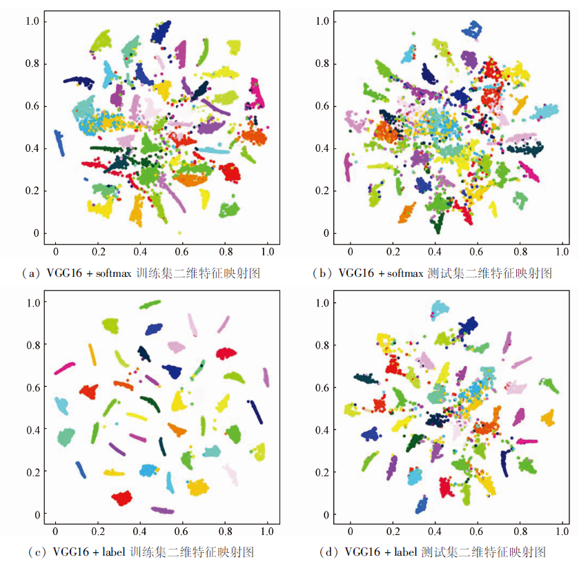
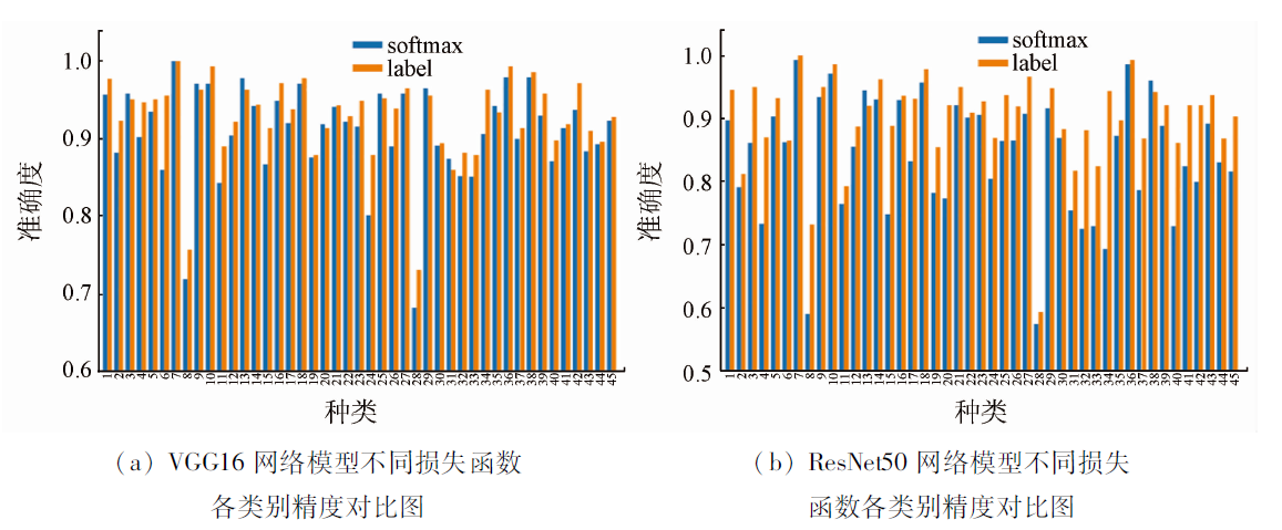
Scene information of remote sensing images has important application value in image interpretation and actual production and life in various fields. In view of the characteristics of remote sensing images with large intra-class differences and small inter-class differences, this paper further studies the center loss function and proposes a new label clustering loss function. Firstly, the class center is initialized by using the class label center initialization method. Secondly, the sinusoidal attenuation learning rate is used to keep the stability of the class center in the preheating stage. Then, Euclidean distance and cosine distance are used to gather the intra-class features and keep them away from the class center. Furthermore, two network models, VGG16 and ResNet50, are used to verify on NWPU-RESISC45 data set, and the accuracy is improved by 2.3% and 5.7% respectively. Experiments show that the method proposed in this paper can effectively cluster the features and separate class centers, and improve the accuracy of the network model, which has a certain development prospect in the classification of remote sensing images.
苏赋, 于海鹏, 朱威西. 标签聚类损失在遥感影像分类中的应用[J]. 自然资源遥感, 2022, 34(2): 144-151.
SU Fu, YU Haipeng, ZHU Weixi. Application of label clustering loss in the classification of remote sensing images. Remote Sensing for Natural Resources, 2022, 34(2): 144-151.
1:输入:网络模型最后一层全连接层特征值{},训练批次大小m,迭代次数T,学习率和∂s 2:初始化: softmax损失参数,类标签中心参数 3: for t=1 to T do 4:计算联合损失: 5:更新softmax损失参数: 6:更新类别中心: 7:更新模型反向传播误差: 8: end for
Li G D, Zhang C J, Wang M K, et al. High resolution remote sensing image classification learning based on convolutional neural network migration[J]. Surveying and Mapping Science, 2019, 44(4):116-123,174.
He X F, Zou Z R, Tao C, et al. High resolution image scene classification based on saliency and multilayer convolutional neural network[J]. Acta Surveying and Mapping, 2016, 45(9):1073-1080.
[3]
Liu Y, Zhong Y, Qin Q. Scene classificationbased on multiscale convolutional neural network[J]. IEEE Transactions on Geoscience and Remote Sensing, 2018, 56(12):7109-7121.
doi: 10.1109/TGRS.2018.2848473
[4]
Zan C, Wang S, X Hou, et al. Recurrent transformer network for remote sensing scene categorisation[C]. // Proceedings of the 2018 British Machine Vision Conference.Durham:BMVA, 2018:266.
[5]
Wang Q, Liu S, Chanussot J, et al. Scene classification with recurrent attention of VHR remote sensing images[J]. IEEE Transactions on Geoscience and Remote Sensing, 2019, 57(2):1155-1167.
doi: 10.1109/TGRS.2018.2864987
[6]
Sun H, Li S, Zheng X, et al. Remote sensing scene classification by gated bidirectional network[J]. IEEE Transactions on Geoscience and Remote Sensing, 2019(99):1-15.
[7]
Li Y, Liu M, Zhang S. Classification of optical remote sensing images based on convolutional neural network[C]// 2019 6th International Conference on Control,Decision and Information Technologies (CoDIT).IEEE, 2019:801-806.
Yang B, Li C H, Jiang X P, et al. A regularized loss function for improving the accuracy of deep learning classification model[J]. Journal of Central South University for Nationalities,Natural Science Edition, 2020, 39(1):74-78.
[9]
Liu Y, Huang C. Scene classification via triplet networks[J]. IEEE Journal of Selected Topics in Applied Earth Observations & Remote Sensing, 2018, 11(1):220-237.
[10]
Khatun A, Denman S, Sridharan S, et al. Joint identification-verification for person re-identification:A four stream deep learning approach with improved quartet loss function[J]. Computer Vision and Image Understanding, 2020,197-198:102989.
[11]
Shi W, Gong Y, Tao X, et al. Fine-grained image classification using modified DCNNs trained by cascaded softmax and generalized large-margin losses[J]. IEEE Transactions on Neural Networks and Learning Systems, 2018, 30(3):683-694.
doi: 10.1109/TNNLS.2018.2852721
[12]
Reddy A C, Saraschandrika A, Reddy A V. Study of the Clustering algorithms for hyper spectral remote sensing images[J]. Journal of Hyperspectral Remote Sensing, 2020, 10(2):117-121.
doi: 10.29150/jhrs.v10.2.p117-121
[13]
Gong C, Han J, Lu X. Remote sensing image scene classification:Benchmark and state of the art[J]. Proceedings of the IEEE, 2017, 105(10):1865-1883.
doi: 10.1109/JPROC.2017.2675998
[14]
He N, Fang L, Li S, et al. Remote sensing scene classification using multilayer stacked covariance pooling[J]. IEEE Transactions on Geoscience and Remote Sensing, 2018,(99):1-12.
Yang H B, Chi Y X, Wang J G. Remote sensing satellite image classification method based on knowledge distillation of pruning net work[J/OL]. Computer Application Research, 2021, 38(8):2469-2473.
Ma X Y, Wang L M, Qi K L, et al. Remotesensing image scene classification method based on multi-scale cyclic attention network[J]. Earth Science, 2021, 46(10):3740-3752.
[17]
Zhou Z, Zheng Y, Ye H, et al. Satellite image scene classification via ConvNet with context aggregation[J]. PCM, 2018(2):329-339.
Ye Q L, Xu X P, Zhang D. Remote sensing image classification based on deep learning feature and support vector machine[J]. Journal of Forestry Engineering, 2019, 4(2):125-131.
[19]
Wang J, Liu W, Ma L, et al. IORN:An effective remote sensing image scene classification framework[J]. IEEE Geoscience and Remote Sensing Letters, 2018, 15(11):1695-1699.
doi: 10.1109/LGRS.2018.2859024
 2022, Vol. 34
  ), 于海鹏(