Exploring the spatio-temporal variations and forest restoration of burned zones in the Great Xing’an Range based on MODIS time series data
WANG Jian1(), DU Yuling1, GAO Zhao2, LYU Haiyan1, SHI Lei1()
1. College of Information and Management Science, Henan Agricultural University, Zhengzhou 450046, China 2. The First Geodetic Survey Team of the Ministry of Natural Resources, Shaanxi Bureau of Surveying, Mapping and Geoinformation, Xi’an 710054, China
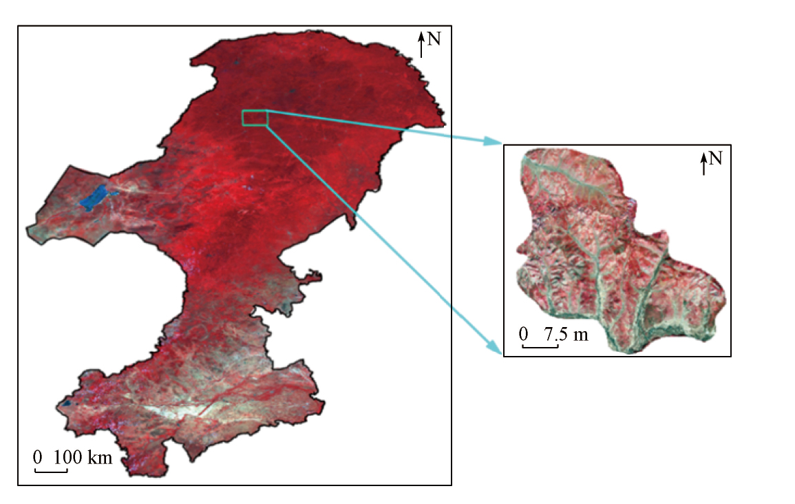
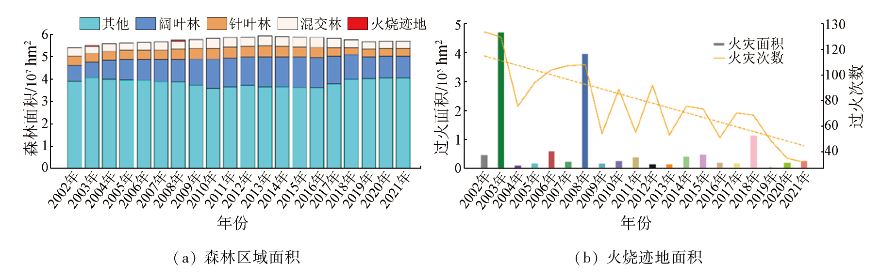
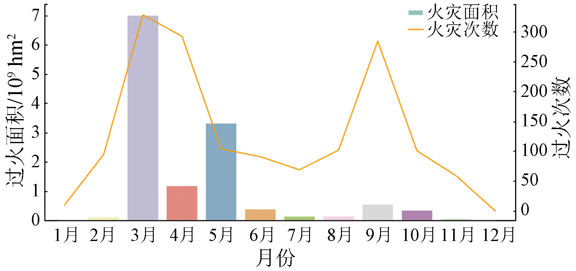
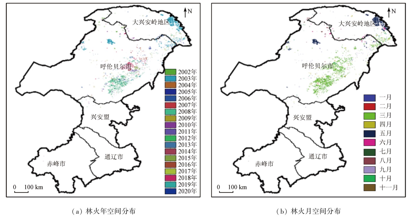
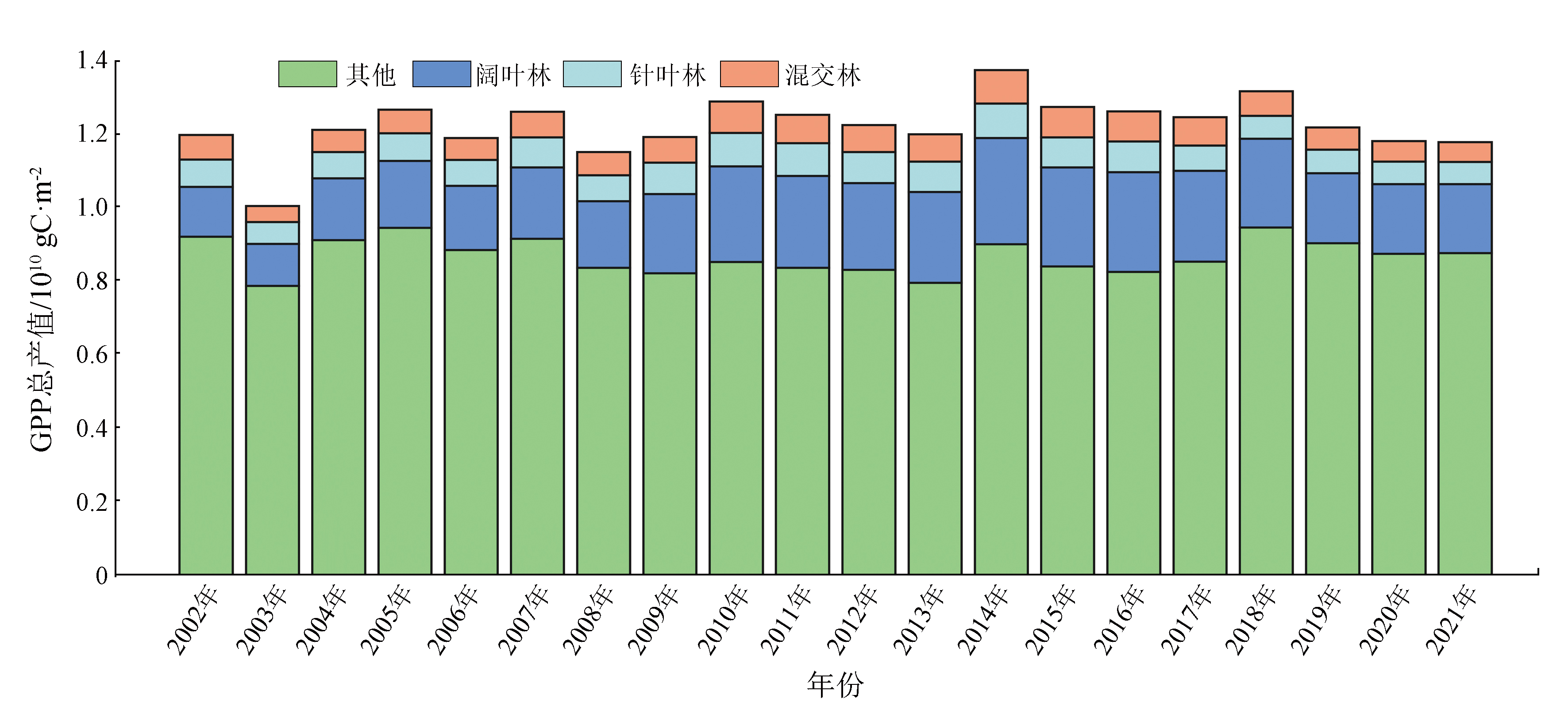
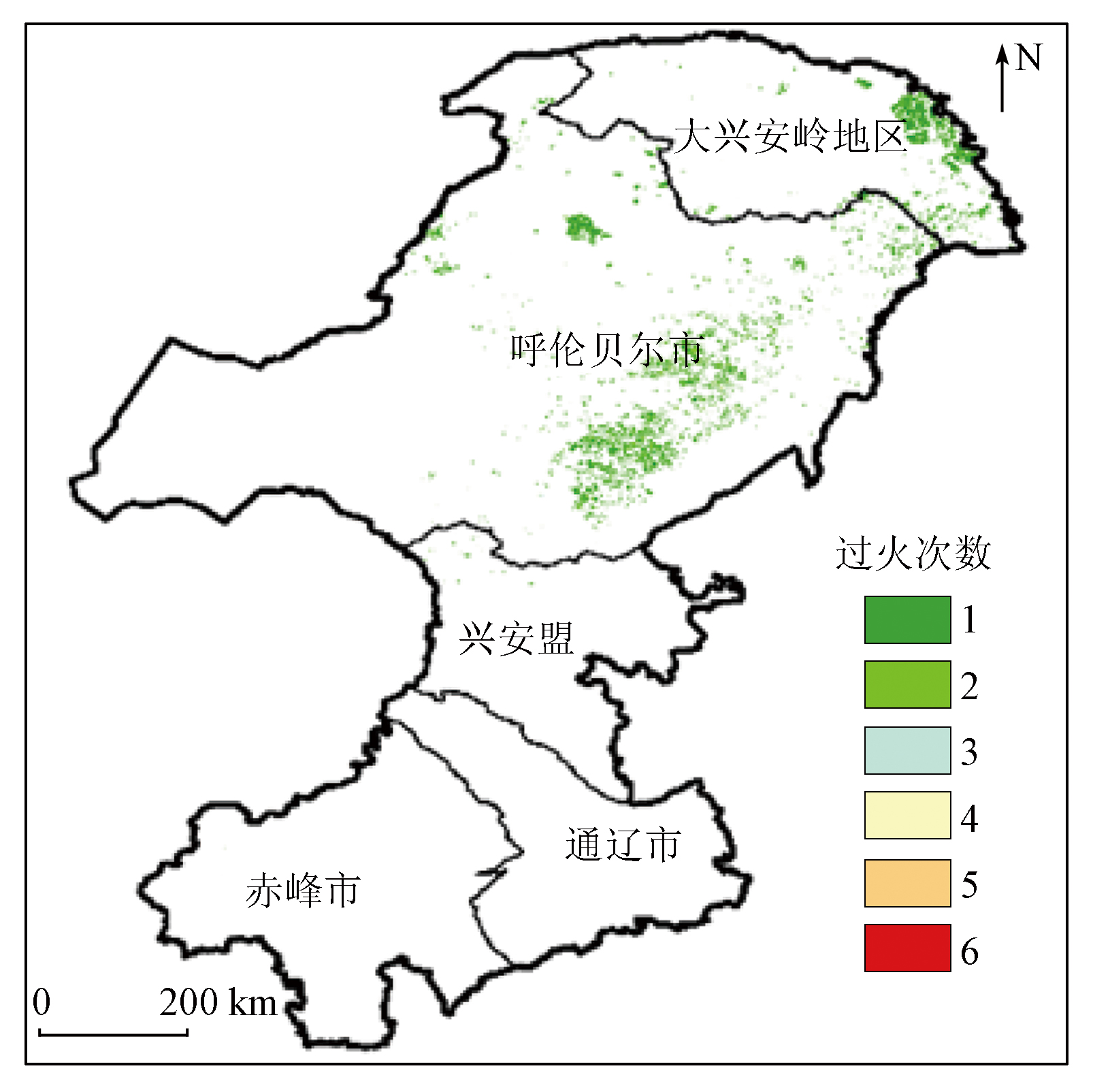
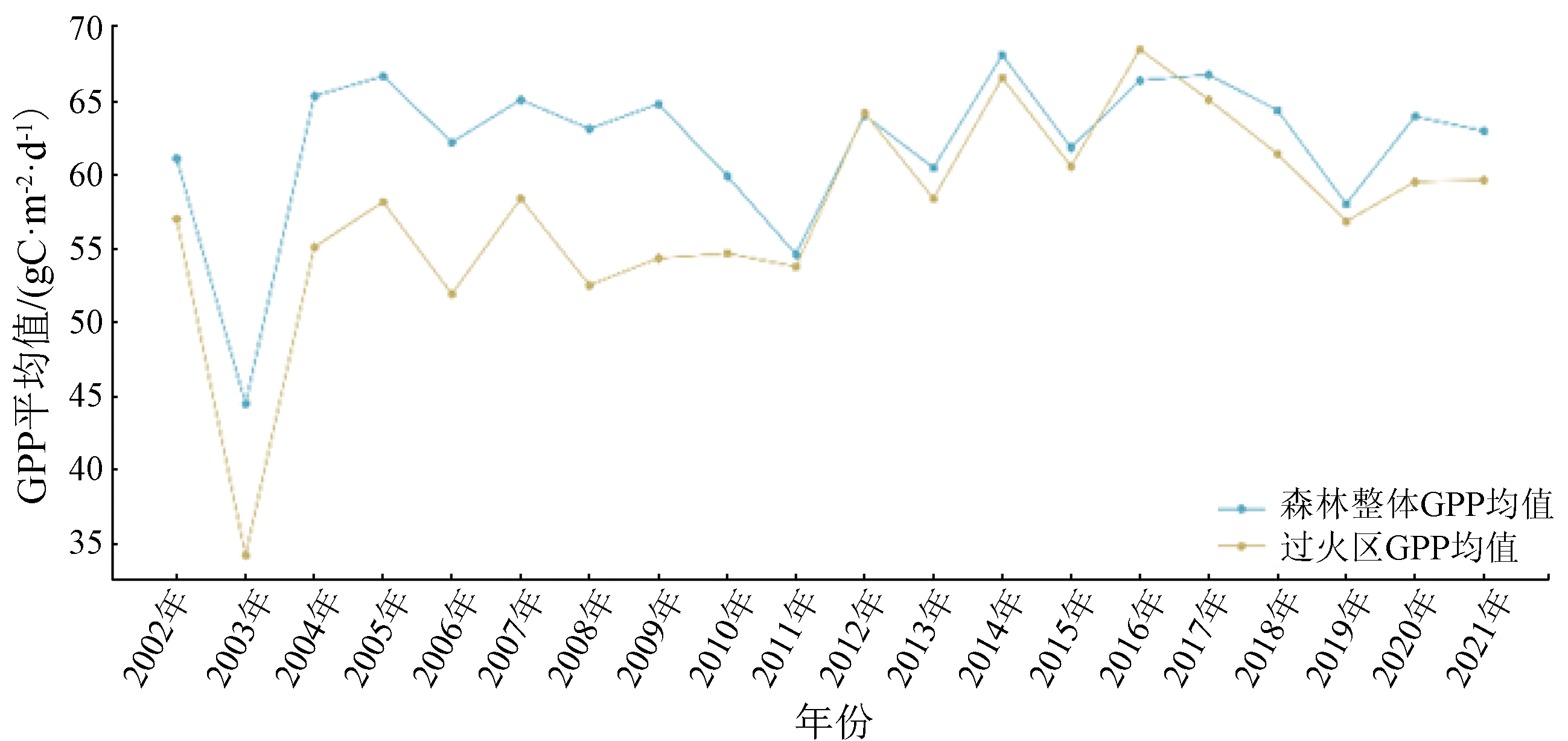
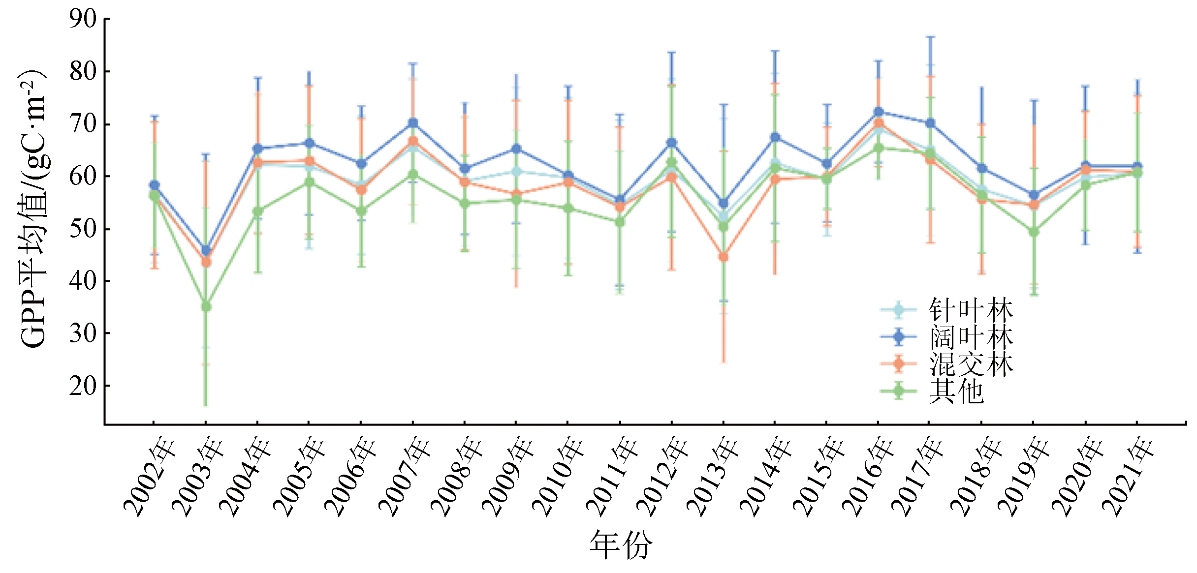
Forest fires are one of the most significant disturbance factors affecting forest ecosystems. Exploring their spatio-temporal variations and forest restoration holds certain sociological and ecological significance. The Great Xing’an Range, possessing the largest primitive area in China, is a key area suffering frequent forest fires. Hence, this study extracted the distribution information of burned zones in the Great Xing’an Range from 2002 to 2021 from the MODIS time series products involving burned zones, land cover, and gross primary productivity (GPP). Moreover, it statistically analyzed the post-fire forest restoration. The results show that: ① Fires in the forest area of the Great Xing’an Range showed an overall downward trend from 2002 to 2021, but the burned areas showed fluctuating changes. Both the burned area and fire frequency were the highest in 2003, followed by 2008, with the lowest burned area seen in 2019; ② Forest fires occurred primarily in spring and autumn, with the highest burned area and fire frequency in March and the second highest fire frequency in September; ③ Forest fires manifested an uneven spatial distribution from northeast to southwest, predominantly in the Great Xing’an Range within Heilongjiang and Hulunbuir City of Inner Mongolia. Moreover, the forest fire area in Inner Mongolia far exceeded that in Heilongjiang. The analysis of forest types in burned zones reveals that the burned areas decreased in the order of broad-leaved, mixed, and needle-leaved forests. According to the time series analysis of GPP in burned zones, GPP values recovered the fastest in the first year post-fire, but it took nearly seven years to recover to the pre-fire growth level. Different forest types manifested significantly distinct post-fire restoration rates, which decreased in the order of broad-leaved, needle-leaved, and mixed forests. Overall, ascertaining the spatio-temporal distribution of forest fires can provide data support for the arrangement and adjustment of fire prevention and control efforts, while investigating the post-fire forest restoration can provide a scientific basis for the rehabilitation and sustainable development of forests.
王健, 杜玉玲, 高钊, 吕海燕, 时雷. 基于MODIS时序数据的大兴安岭火烧迹地时空变化及其森林恢复研究[J]. 自然资源遥感, 2024, 36(2): 142-150.
WANG Jian, DU Yuling, GAO Zhao, LYU Haiyan, SHI Lei. Exploring the spatio-temporal variations and forest restoration of burned zones in the Great Xing’an Range based on MODIS time series data. Remote Sensing for Natural Resources, 2024, 36(2): 142-150.
Ma Z Y, Chen B W, Pang Y, et al. Forest fire potential forecast based on FCCS model[J]. Remote Sensing for Land and Resources, 2020, 32(1) :43-50.doi:10.6046/gtzyyg.20200107.
[3]
Sannigrahi S, Pilla F, Basu B, et al. Examining the effects of forest fire on terrestrial carbon emission and ecosystem production in India using remote sensing approaches[J]. The Science of the Total Environment, 2020, 725:138331.
Chen Y Y, Ma X C, Xu Y P, et al. Methods for the application of topography and NDVI in re- identification of remote sensing - based monitoring of forest fires[J]. Remote Sensing for Natural Resources, 2022, 34(3):88-96.doi:10.6046/zrzyyg.2021142.
[5]
Li Q, Cui J, Jiang W, et al. Monitoring of the fire in Muli County on March 28,2020,based on high temporal-spatial resolution remote sensing techniques[J]. Natural Hazards Research, 2021, 1(1):20-31.
[6]
Pérez-Cabello F, Montorio R, Alves D B. Remote sensing techniques to assess post-fire vegetation recovery[J]. Current Opinion in Environmental Science and Health, 2021, 21:100251.
[7]
Marcos B, Gonçalves J, Alcaraz-Segura D, et al. Improving the detection of wildfire disturbances in space and time based on indicators extracted from MODIS data:A case study in northern Portugal[J]. International Journal of Applied Earth Observation and Geoinformation, 2019, 78:77-85.
[8]
Morton D C, DeFries R S, Nagol J, et al. Mapping canopy damage from understory fires in Amazon forests using annual time series of Landsat and MODIS data[J]. Remote Sensing of Environment, 2011, 115(7):1706-1720.
[9]
Giglio L, Roy D P. Assessment of satellite orbit-drift artifacts in the long-term AVHRR FireCCILT11 global burned area data set[J]. Science of Remote Sensing, 2022, 5:100044.
[10]
Roy D P, Li Z, Giglio L, et al. Spectral and diurnal temporal suitability of GOES Advanced Baseline Imager (ABI) reflectance for burned area mapping[J]. International Journal of Applied Earth Observation and Geoinformation, 2021, 96:102271.
[11]
Giglio L, Boschetti L, Roy D P, et al. The Collection 6 MODIS burned area mapping algorithm and product[J]. Remote Sensing of Environment, 2018, 217:72-85.
doi: 10.1016/j.rse.2018.08.005
pmid: 30220740
[12]
Zhao J, Wang J, Meng Y, et al. Spatiotemporal patterns of fire-driven forest mortality in China[J]. Forest Ecology and Management, 2023, 529:120678.
Yu H T, Geng J, Adana H, et al. Remote sensing monitoring of forest fires in Australia from 2019 to 2020[J]. Bulletin of Surveying and Mapping, 2021(s1):165-169.
Zeng A C, Guo X B, Zheng W X, et al. Temporal and spatial dynamic characteristics of forest fire in Zhejiang Province of eastern China based on MODIS satellite hot spot data[J]. Journal of Beijing Forestry University, 2020, 42(11):39-46.
Cui Y, Di H T, Xing Y Q, et al. Spatial and temporal distributions of forest fires in Heilongjiang Province from 2001 to 2018 based on MODIS data[J]. Journal of Nanjing Forestry University (Natural Sciences Edition), 2021, 45(1):205-211.
[16]
Nolè A, Rita A, Spatola M F, et al. Biogeographic variability in wildfire severity and post-fire vegetation recovery across the European forests via remote sensing-derived spectral metrics[J]. Science of the Total Environment, 2022, 823:153807.
[17]
Hislop S, Haywood A, Jones S, et al. A satellite data driven approach to monitoring and reporting fire disturbance and recovery across boreal and temperate forests[J]. International Journal of Applied Earth Observation and Geoinformation, 2020, 87:102034
[18]
Qin Y, Xiao X, Wigneron J P, et al. Large loss and rapid recovery of vegetation cover and aboveground biomass over forest areas in Australia during 2019-2020[J]. Remote Sensing of Environment, 2022, 278:113087.
Tian X R, Dai X, Wang M Y, et al. Forest fire risk assessment for China under different climate scenarios[J]. Chinese Journal of Applied Ecology, 2016, 27(3) :769-776.
Liu X G, Yan Z S. Analysis of meteorological conditions in the early stage of spring forest fire in Daxing’anling in 2003[J]. Heilongjiang Meteorology, 2003, 20(4):29-30.
Wu Z W, Chang Y, He H S, et al. Analyzing the spatial and temporal distribution characteristics of forest fires in Huzhong area in the Great Xing’an Mountains[J]. Guangdong Agricultural Sciences, 2011, 38(5):189-193.
Zhu H, Zhang Z, Yang S, et al. Temporal and spatial distribution of forest fire and the dynamics of fire danger period in southern and northern China:A case study in Heilongjiang and Jiangxi Provinces[J]. Chinese Journal of Ecology, 2023, 42(1):198-207.
Sa R L, Zhou Q, Liu X Y, et al. Studies on the spatial and temporal dynamics of forest fires in Inner Mongolia from 1980 to 2015[J]. Journal of Nanjing Forestry University (Natural Sciences Edition), 2019, 43(2):137-143.
Zhang H, Ao Z Q, Wu R H, et al. Study on physicochemical properties and fire-resistance of main tree and shrub species in Daxing’an Mountains,Inner Mongolia[J]. Journal of Southwest Forestry University(Natural Sciences), 2020, 40(4):61-67.
 2024, Vol. 36
  ), 杜玉玲1, 高钊2, 吕海燕1, 时雷1(